![]()
Clayton Co. Iowa Cemetery Records The burial records are updated very frequently, often daily! *Offsite cemetery records are marked as such - please report broken links so they can be fixed! |
Have you walked a
Clayton co. cemetery?
Please consider sharing your information with other researchers.
(please click here for the email
address)
~*~*~
|
|
|
|
||
Cemetery Directory
| CEMETERY | LOCATION |
|---|---|
| Amish - on Amish farm) | Volga Twp. |
| Apostolic
- aka Dunkard/German Bottoms cemetery * A-J * K-Z |
Sec 29 NW/NW, Marion Twp. 42.935ºN / 91.582ºW |
| Asbury | Sec 9 NE/SW, Elk Twp. 42.711ºN / 91.320ºW |
| Baumgartner - Art Baumgartner's baby | Sec 28, Sperry Twp |
| Baylis | SE corner of SE NE, Sec. 8
(south) Mendon twp. Kimberly Ave. -91.211000 42.972213 |
| Bethel * A-G * H * J-M * N-R * S-Z * |
Sec 11 SW/SW, Mallory Twp. 42.704ºN / 91.169ºW |
| Berns -The cemetery was located near Ceres, on a farm homesteaded in 1847 by Theodore & Mary Berns. It was witched in the 1990's by Herb Kann and 80 graves were found. Gilbert J. & Mary A. (Berns) Muller owners of the farm, made plans to level, plant prairie grass & fence the area. It is unknown when all the gravestones, trees and iron fence around the cemetery were removed. | Sec 2 NE/NE, Jefferson Twp. |
| Bierer | Sec 4 SW/SW, Millville Twp. 42.725ºN / 91.083ºW |
| Bischoff - one grave, name unkn. | Sec 33 center, Jefferson Twp |
| Bismark - aka Winkowitch cemetery | Farmersburg, Sec 6,
Farmersburg Twp. 42.979ºN / 91.350ºW |
| Blanchaine
- aka Ruegnitz * Burials as recorded by Dwight Hansel, 2005 - updated when additional burials are found * WPA records |
Sec 28, NE¼ / NW¼, Volga
Twp (42.759919 / -91.310660) north of Grandview Rd. out of Elkport |
| Bolsinger | Sec 24 NE/SW, Mallory Twp. 42.678ºN / 91.142ºW |
| Borcherding | Sec 1 NW/NE, Jefferson Twp. 42.818ºN/ 91.141ºW |
| Brookshier - aka Elk Valley cemetery, aka Taylor cemetery | 26 SW/NW, Elk Twp. 42.671ºN / 91.290ºW |
| Brorby - abandoned | Sec 4 SW/SW, Marion Twp |
| Brown * Alphabetical Name index A-K * Alphabetical Name index L-Z * Section A * Section B * Section C * * unknown section & cemetery association * News article: re-interments (1900) |
Sec 33 SW/NE, Mallory Twp. 42.653ºN / 91.201ºW |
| Brown, John L. - one grave/marker; 3 yr old | Sec 8 SWSW, Millville Twp. |
| Buell Park - town of McGregor - compiled history of the burial site of James McGregor, Jr. | Sec 28, Mendon Twp. 43.017ºN / 91.200ºW |
| Buena Vista Twp | Sec 27, Buena Vista Twp. 42.678ºN / 90.954ºW |
| Cass township - see Strawberry Point cemetery | Strawberry Point, Cass Twp. 42.681ºN / 91.523ºW |
| Ceres - aka Independence/Pioneer Rock | Sec 34 NW/SW, Garnavillo Twp. 42.823ºN / 91.186ºW |
| Clark Family cemetery | St. Olaf, Sec 31, Wagner Twp. 42.917ºN / 91.475ºW |
| Clayton * A-H * J-Y |
Clayton, Sec 2, Clayton Twp. 42.904ºN / 91.164ºW |
| Clayton Center & Zion
Lutheran cemeteries - either may be referred to
as "Read cemetery" in some records * A-G * H-L * M-R * S-Z * |
Sec 9 NW/SW, Read Twp. 42.884ºN / 91.323ºW |
| Colony Catholic -Abandoned - remains re-interred) | Sec 7 NW/NW, Read Twp. 42.883ºN / 91.358ºW |
| Communia | Communia, Sec 18, Volga Twp. 42.787ºN / 91.363ºW |
| Cook | Sec 26 SE/SE, Marion Twp. 42.958ºN / 91.542ºW |
| Cords - aka Osborne | Osborne, Sec 9. Cox Creek Twp. (part of SE NW 9-92-5) -91.438049 42.797285 |
| Council
Hill - gravestones recorded
as of 2010, with continuing updates: A-L * M-Z * Council Hill plot map - the file is in .pdf format & opens in a new window. To view, you will need Adobe-Reader * Archived files, incomplete & mostly WPA records - no longer updated: A-L * M-Z |
Sec 3 NE/SW, Giard Twp. 43.072ºN / 91.300ºW |
| County Corners | 10027 A Ave.; Sec. 31,
SW/SW, Cass twp. -91.606004 42.64410 |
| County Home - aka Poor Farm or County Care cemetery | Sec 7 NW/NE, Read Twp. 42.892ºN / 91.350ºW |
| Dittmer - aka St. John's/Niehaus | Section 30 SE/SE, Jefferson Twp. 42.750ºN / 91.113ºW |
| Dohrer | Sec 5 SE/SE, Cox Creek Twp. 42.813ºN / 91.458ºW |
| Duff - one marker against tree | Sec 29 NW/NE, Highland Twp. 42.842ºN / 91.583ºW |
| Dunkard - aka Apostolic/German Bottoms cemetery | Sec 29 NW/NW, Marion Twp. 42.935ºN / 91.582ºW |
| East
Clermont Lutheran * A-G * H-M * N-Z |
Clermont, Sec 3, Grand
Meadow Twp. 42.997ºN / 91.592ºW |
| Eastman * Burials * Cemetery restoration |
McGregor, Sec 29, Mendon Twp. 43.001ºN / 91.219ºW |
| East
Side - Elkader * A-C * D-H * I-K * L-N * O-Q * R-S * T-Z * East Side Cemetery Association *off-site - East Side cemetery records (Elkader Chamber of Commerce website .pdf file opens in a new window) |
Elkader, Boardman Twp. 42.854ºN / 91.400ºW |
| Ebenezer
- aka Wood Community/Woodland - gravestones as
recorded by Phyllis Peterson Ebenezer - WPA records |
Sec 21 SW/NW, Elk Twp. 42.678ºN / 91.325ºW |
| Eberhard | Littleport, Sec 29 NW/SE Volga Twp |
| *Edgewood - Honey Creek twp. Delaware Co. (many people buried in this cemetery lived in Edgewood, Clayton co.) | Edgewood, Honey Creek twp. Delaware County, Iowa |
| Eggart | Sec 12, Volga Twp |
| Ehrhardt / Erhardt - private) | Sec 31, Boardman Twp. 42.825ºN / 91.475ºW |
| Elk Valley / Elk Creek - aka Taylor cemetery, aka Brookshier cemetery | 26 SW/NW, Elk Twp. 42.671ºN / 91.290ºW |
| Eno | Sec 6 NE/NE, Wagner Twp. 42.993ºN / 91.469ºW |
| Evangelical Lutheran - Reformed Congr. | Sec 11 NE/SW, Garnavillo Twp. 42.883ºN / 91.167ºW |
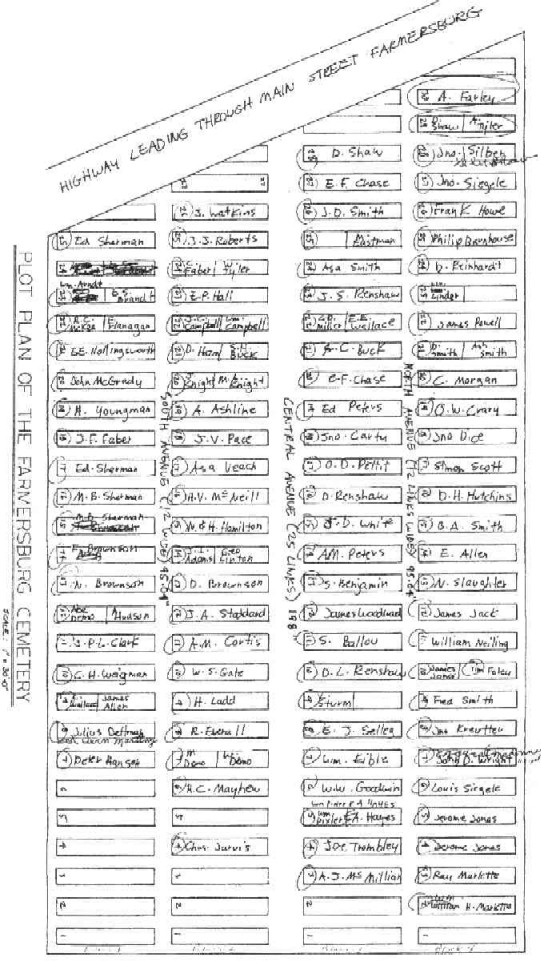
| Farmersburg
- National - aka National cemetery * Burials * Plots * Plotmap |
Sec 15 SE, Farmersburg Twp. 42.954ºN / 91.290ºW |
| Farmersburg
- Wagner - aka Wagner cemetery * A-J * K-M * N-Z * Farmersburg-Wagner Cemetery Assoc. |
Sec 24 NE/NE, Wagner Twp. 42.948ºN / 91.370ºW |
| First Evangelical Lutheran - aka Swedish/Norsk cemetery | McGregor, Sec. 10, Mendon twp. 42.971ºN/ 91.176ºW |
| Friedlein
- aka Millville or Richardson cemetery * Burials * History of Friedlein cemetery |
Sec 8 SW/SW, Millville Twp. 42.708ºN / 91.111ºW |
| Friendship Center - abandoned | Sec 10 (south), Mendon Twp |
| Fry - aka George Fry cemetery | Sec 26 NW/NE, Grand Meadow Twp. 43.015ºN / 91.518ºW |
| Garber - Old Garber cemetery - aka Garber family cemetery | Garber, Sec 25, Volga Twp. 42.756ºN / 91.258ºW |
| Garretson - compiled records | Sec 30 NW/SW, Sperry Twp |
| Garnavillo
- aka Garnavillo Community cemetery * Sexton's Records -transcribed by Jane Thein * Alphabetical index: A-H *I-N *O-S *T-Z * Burials: Block 1 * Block 2 * Block 3 * Block 4 * Block 5 * Block 6 * Block 7 * Block 8 * Block 9 * Block 10 * Block 11 * Block 12 * Block 14 (as of 8/3/2023 there are no burials in Bl 13) |
Sec 18 SW/SW, Garnavillo Twp |
| Garnavillo - Old cemetery | Sec 18 SE/SW, Garnavillo Twp. 42.866ºN / 91.241ºW |
| Giard *A - D * E - K * L - R * S - Z (includes misc. cemetery assoc. records) *Mowing the Cemetery - by Bev Bernhard *Giard (archived file, incomplete & mostly WPA records) |
Giard, Sec 3 Farmersburg Twp. 42.993ºN / 91.308ºW |
| Gillett - markers removed - no other information | 8 W 1/2, Garnavillo Twp |
| Gooding * Burials * Cemetery Association history * Plot map (undated) |
Sec 3 SW/SW, Wagner Twp. 42.987ºN / 91.419ºW |
| Goshen * Record of burials * WPA records, soldier burials & lot owners |
Sec 15 SE/SE, Millville Twp. 42.691ºN / 91.054ºW |
| Graham | Graham, Sec 19, Millville Twp. 42.683ºN / 91.119ºW |
| Grand
Meadow - aka Ridley cemetery * Burials * Cemetery Association records 1862-1900 |
Sec 12, Grand Meadow Twp. 43.063ºN / 91.508ºW |
| Greenhill
/ Green Hill - aka
Platt cemetery * Walked & photographed by P. Peterson, 2004 - updates will be added as needed * WPA records - records will not be updated or edited |
Sec 22 SE/SW, Lodomillo Twp. 42.674ºN / 91.421ºW |
| Greybill - Neoma's baby | Sec 16 NE, Millville Twp. |
| Griffith - aka Livingston cemetery (2 markers, remainder in nearby ditch) - no burial list known to exist | Sec 18 SE/SE, Millville Twp. 42.683ºN / 91.117ºW |
| Guttenberg
City -researchers should
take advantage of both burial databases. |
Sec 20 NE/SW, Jefferson Twp. 42.769ºN / 91.104ºW |
| Hall
- aka Mount Harmony * A-I * J-Q * R-Z * Cemetery Association |
Sec 11 NW/NE, Elk Twp. 42.718ºN / 91.280ºW |
| Hall - Hannah Hall buried, abandoned | Highland Twp |
| Hamlett - walked & photographed by P. Peterson, 2005; also WPA records | 33 NW/NE, Elk Twp. 42.658ºN / 91.310ºW |
| Hansel * Burials recorded by Lyle Morley: A-H * I-Z * Burials, source unknown |
Sec 7 NE/SW, Mallory Twp.
42.707ºN / 91.243ºW |
| *off-site Hardin - the village of Hardin was located in both Allamakee & Clayton counties, but the cemetery is geographically in Allamakee county | Franklin twp., Allamakee co. IA |
| Hartman | Sec 2 NE/NE, Cox Creek Twp. 42.816ºN / 91.388ºW |
| Hartshey - no markers | Sec 26 NW/NE, Volga Twp. 42.756ºN / 91.283ºW |
| Highland Lutheran | Elkader, Sec 3, Highland Twp. 42.899ºN / 91.533ºW |
| Hill - abandoned | Sec 21, Clayton Twp |
| Hillcrest
* A-B * C-D * E-F * G-I * J-L * M-O * P-R * S * T-Z * Cemetery Association & a few facts re: the cemetery |
12818 Cass St., Volga Sperry Twp., Sec 9 NE NE 9-92-6 |
| Houg - aka Mork | Sec 20 SE/NE, Marion Twp. 42.944ºN / 91.568ºW |
| Humphrey Catholic - aka Pioneer Catholic | Monona, Sec 27, Monona Twp. 43.015ºN / 91.428ºW |
| Illyria
- many Clayton co. residents are buried in this cemetery * A-K * L-Y * also check this off-site list of burials - Illyria - Highland cemetery (Fayette co. IAGenWeb) |
Fayette co., Sec 2, Illyria Twp. 42.898N / 91.635W; Highway 56 on the border of Highland Twp, Clayton co. |
| Immaculate
Conception * Survey - by L. Gassman, with on-going updates: Alphabetical: A-H * J-Z * Burials by row: 1-5 * 6-12 * WPA records archived & incomplete (older file) |
Sec 21 Buena Vista Twp. 42.683ºN / 90.956ºW |
| Immanuel Lutheran - Elkport (with St. Michael's Catholic cemetery) | Sec 35 NE/NE, Elkport, Volga Twp. 42.742ºN / 91.283ºW |
| Independence - aka Ceres/Pioneer Rock | Sec 34 NW/SW, Garnavillo Twp. 42.823ºN / 91.186ºW |
| Ingram (road changed, burial(s) in ditch) | Sec 10 NE, Sperry Twp. East of Volga |
| Iowa Veterans Cemetery, Dallas co. IA - Burials of Veterans & spouses with a Clayton co. connection | 34024 Veterans Memorial Dr. Adel, Dallas county, IA Location |
| Jenkins (markers removed) | 6 SW/NE, Garnavillo Twp. 42.900ºN / 91.242ºW |
| Johanningmeier (markers & remains removed) | Sec 29?, Wagner Twp. 42.928ºN / 91.458ºW |
| Kahr (Kahr girl) | Sec 29 NE, Cox Creek Twp |
| Kann - aka St. Michael's Catholic | Sec 3 NW/SE, Jefferson Twp. 42.806ºN / 91.180ºW |
| Kenyon, John (3 yr old boy) | Sec 22 NW/SE, Millville Twp |
| Knapp Includes burial list, 1874 plot map, 1890 Quit Claim & 1892 land sale documents | Sec 8 NW/NE, Mendon Twp. 43.064ºN / 91.221ºW |
| Koenig (markers were removed) | Sec 3 NW/SW, Mallory Twp. 42.725ºN / 91.183ºW |
| Kreimer - aka Krumm/Pine Hollow | Garber, Sec 10, Volga Twp. 42.791ºN / 91.302ºW |
| Kruger | Sec 9 NE/NW, Jefferson Twp |
| Krumm - aka Kreimer/Pine Hollow | Garber, Sec 10, Volga Twp. 42.791ºN / 91.302ºW |
| Lamphier, Earl & Myrtle - ashes buried on farm | Sec 16 NW/NW, Sperry Twp |
| Lenth - mother & child | Farmersburg Twp. |
| Lewis | Jefferson Twp. 42.742ºN / 91.183ºW |
| Lodomillo - aka Noble (original burial list as of 2004, updated 2021) | Sec 28 NW/NW, Lodomillo Twp. 42.674ºN / 91.447ºW |
| Luana City - rural Luana | Luana, Sec 8, Monona Twp. 43.060ºN / 91.468ºW |
| Marion
Lutheran - Gunder * Surnames: A-G and unknown * H-M * N-Z |
Gunder, Sec 11, Marion Twp. 42.971ºN / 91.513ºW |
| McCleland
Family cemetery - historical informaton,
photos & more McCleland cemetery - gravestone photos w/GPS info. |
33 NE/NW, Garnavillo Twp. 42.825ºN /91.208ºW |
| McGregor Family cemetery - compiled history of the now abandoned cemetery | Sec 27, Mendon Twp. |
| Mederville (includes Cemetery Association info.) | 31822 Evergreen Rd. part of SE SW Sec 22-92-5, Cox Creek twp. -91.419379 42.76366 |
| Meenan | Communia, Sec 7, Volga Twp. 42.800ºN / 91.358ºW |
| Meyer Family cemetery | Sec 4 NE/SE, Cox Creek Twp. 42.811ºN / 91.438ºW |
| Millville
- aka Friedlein/Richardson * Burials * History of Friedlein cemetery |
Sec 8 SW/SW, Millville Twp. 42.708ºN / 91.111ºW |
| Millville Pioneer Cemetery - only known burial was Fenttenage or Fettenage, George (died Dec. 1877; aged 67 yrs); over 80 graves in this cemetery at one time, with the last gravestone stolen, as reported by Clayton Co. Genealogy Soc. in a 8/30/2000 news article | Sec line 23SE/24SW, west of Errthum Rd., Millville Twp |
| Monona
City (aka Monona Eastside) * A-B * C-D * E-G * H-I * J-K * L-M * N-Q * R-S * T-Z * Monona City Cemetery Association * Veteran Burials |
Monona, Sec 12, Monona Twp. 43.053ºN / 91.380ºW |
| Moody | Sec 34 NW/SW, Mendon Twp. 43.003ºN / 91.189ºW |
| Mork - aka Houg | Sec 20 SE/NE, Marion Twp. 42.944ºN / 91.568ºW |
| Mount
Harmony / Mt. Harmony - aka
Hall cemetery * A-I * J-Q * R-Z * * Cemetery Association |
Sec 11 NW/NE, Elk Twp. 42.718ºN / 91.280ºW |
| Mount
Olivet Catholic
* A-K * L-Z * Mt. Olivet is the newer of the two cemeteries associated with St. Mary's Catholic church, Guttenberg (the older cemetery is St. Mary's Catholic/Nieland) |
Guttenberg, Sec 18, Jefferson Twp 42.777ºN / 91.109ºW |
| Musfeldt | Sec 32 SW/NE, Volga Twp. 42.740ºN / 91.334ºW |
| National
- aka Farmersburg - National * Burials * Plots * Plotmap |
Sec 15 SE, Farmersburg Twp. 42.954ºN / 91.290ºW |
| Niehaus (aka St. John's/Dittmer) | Section 30 SE/SE, Jefferson Twp. 42.750ºN / 91.113ºW |
| Niehaus - burial names unknown, 3 trees mark the cemetery | Sec 17 NE, Millville Twp |
| Nieland
- aka St. Mary's Catholic cemetery - Guttenberg * A-M * N-Z |
Guttenberg, Sec 19,
Jefferson Twp. 42.769ºN / 91.135ºW |
| Noble - aka Lodomillo cemetery (original burial list as of 2004, updated 2021) | Sec 28 NW/NW, Lodomillo Twp. 42.674ºN / 91.447ºW |
| Noggle - as recorded by Sandy Emerick in 2001 | Sec 26 NE¼ SW¼ Mallory twp. (east of 385th St.) 43.6679ºN/91.1664ºW |
| Norsk - aka First Evangelical Lutheran/Swedish | McGregor, Sec. 10, Mendon twp. 42.971ºN/ 91.176ºW |
| Norway * A-H (also unknown surnames) * I-M * N-Z |
St Olaf, Wagner Twp. 42.935ºN / 91.430ºW |
| Norwegian - aka Stavanger | Sec 10 Mendon Twp. |
| *off-site Oak Hill - Colony twp. Delaware Co. Iowa (new window opens) | Colesburg, Delaware County |
| Oakland & Oak Wood - see Pleasant Grove cemetery | McGregor, Sec 21, Mendon Twp. 43.027ºN / 91.195ºW |
| Old Stone School - aka Stone School cemetery | Sec 9 SW/NW, Sperry Twp |
| O'Donnell - Dr. Francis C. O'Donnell DVM, buried on his farm, 05/22/1918-02/08/1998 | Sec 16 SESW, Cass Twp., along Amissions Rd |
| Oldfather (two baby boys of Ina & Frank Oldfather) | Sec 8 SE, Sperry Twp |
| Oldfather (baby boy of Ina & Frank Old) | Sec 7 SW, Sperry Twp |
| Osborne - aka Cords cemetery | Osborne, Sec 9. Cox Creek Twp. (part of SE NW 9-92-5) -91.438049 42.797285 |
| Oslien (no markers) | Sec 26 SE/SE ??, Marion Twp |
| Osmundson (Danielle Marie-aged 2 days) | Sec 34, Osmundson farm; Highland Twp |
| Patterson | St Olaf, Sec 29, Wagner Twp. 42.928ºN / 91.458ºW |
| Pine Hollow - aka Kreimer/Krumm | Garber, Sec 10, Volga Twp. 42.791ºN / 91.302ºW |
| Pioneer Catholic - aka Humphrey Catholic | Monona, Sec 27, Monona Twp. 43.015ºN / 91.428ºW |
| Pioneer Rock - aka Ceres/Independence | Sec 34 NW/SW, Garnavillo Twp. 42.823ºN / 91.186ºW |
| Pleasant
Grove - originally known as Oakland cemetery
and occasionally in old records as Oak Wood cemetery.
Establishment of this cemetery is closely tied to the McGregor Family cemetery. * A-B * C-D * E-F * G-H * I-K * L * M-N * O-R * S-U * V-Z |
McGregor, Sec 21, Mendon Twp. 43.027ºN / 91.195ºW |
| Point Ann | Sec 27, Mendon Twp. 43.021ºN / 91.183ºW |
| Postville
....... Note: Postville is in Allamakee co. - the
cemetery adjoins the town, but is in Clayton county * Area A * Area B * Area C * Area D * Area E * Area F * Area G * Area - other * Cemetery Association |
Sec 4 NW/NW, Grand Meadow
Twp. 43.081ºN / 91.566ºW |
| Railroad Employee (Chinese workers/markers removed) | Sec 21 SW/SW, Giard Twp. 43.031ºN / 91.314ºW |
| Redman | Sec 9 SE/NW, Millville Twp. 42.708ºN / 91.083ºW (West of Noble Road) |
| Reed | Sec 31 SW, Sperry Twp. 42.736ºN / 91.605ºW |
| Richardson
- aka Friedlein/Millville * Burials * History of Friedlein cemetery |
Sec 8 SW/SW, Millville Twp. 42.708ºN / 91.111ºW |
| Rodenberg (?) (7 graves) | Sec 14 SW/NW, Jefferson Twp. |
| Ross | Cox Creek, Sec 25, Sperry Twp. 42.753ºN / 91.493ºW |
| Rothfusz baby (body removed, no marker) | Sec 17 NW/SE, Cox Creek Twp. 42.783ºN / 91.583ºW |
| Ruegnitz
- aka Blanchaine cemetery * Burials as recorded by Dwight Hansel, 2005 * WPA records |
(see Blanchaine) |
| Sacred Heart Catholic (Littleport) | Sec 36, Cox Creek Twp. just
south of Littleport, just across Littleport Rd. from Union cemetery. |
| Sacred Heart Catholic (Cox Creek Catholic Church) | Sec 25, Sperry Twp. 42.743ºN / 91.375ºW |
| Sacred Heart Catholic - aka Schoolhouse Yard - Volga City | 12819 Cass St., Volga Sperry twp. Section 4 SE SE 4-92-6 1 acre 42.805ºN / 91.551ºW |
| Schmidt Family - burials researched by S. Ferrall, includes additional info. on the family | Sec 10 SE/NW, Cox Creek Twp |
| Schoolhouse Yard - aka Sacred Heart Catholic - Volga City | 12819 Cass St., Volga Sperry twp. Section 4 SE SE 4-92-6 1 acre 42.805ºN / 91.551ºW |
| Schori / Schory / Shory | Sec 19 SW/SW, Marion Twp |
| Seeman | (not located) Jefferson Twp |
| Sergeant (markers removed) | (not located) Sec 12 NW/NE? Jefferson Twp |
| Smith - private family cemetery | Sec 23 NE, Cox Creek Twp. on the corner, north of Feather Rd. |
| St John's - aka Niehaus/Dittmer | Section 30 SE/SE, Jefferson Twp. 42.750ºN / 91.113ºW |
| St
John's Lutheran - aka Luana Lutheran
cemetery * Burials * Cemetery Association |
Sec 8 SW/NW, Monona Twp. 43.063ºN / 91.455ºW |
| St Joseph's Catholic -
Elkader * A-C * D-G * H-L * M-O * P-Z * |
Elkader, Boardman Twp |
| St.
Joseph's Catholic - Garnavillo * A-D * E-L * M-R * S-Z St. Joseph's Catholic - cemetery section map & grave survey June 2013 by Jessica Klein * A-K * L-Z |
Garnavillo, Sec 24 NE/NE, Garnavillo Twp |
| *off-site St. Mark Catholic Honey Creek twp. Delaware Co. Iowa (new window) - many people buried here were residents of Clayton county | Edgewood, Honey Creek Twp., near Lodomillo twp. Clayton co. |
| St. Mary's Catholic - Strawberry Point | Strawberry Point, Cass Twp |
| St.
Mary's - aka Nieland
cemetery - Guttenberg * A-M * N-Z |
Guttenberg, Sec 19, Jefferson Twp. 42.769ºN / 91.135ºW |
| St Mary's
Catholic - aka St. Pius - McGregor * A-J * K-Z |
McGregor, Sec 27, Mendon Twp |
| St Michael's Catholic - aka Kann | Sec 3 NW/SE, Jefferson Twp. 42.806ºN / 91.180ºW |
| St Michael's Catholic - Elkport (with Immanuel Lutheran cemetery) | Sec 35 NE/NE, Elkport, Volga Twp. 42.742ºN / 91.283ºW |
| St.
Patrick's Catholic - Monona
* A-K * L-Z |
Sec 13 NE/NW, Monona Twp. 43.033ºN / 91.400ºW |
| St.
Paul's Lutheran - Monona * A-J * K-Z |
Monona, Sec 13, Monona Twp. 43.049ºN / 91.385ºW |
| St. Paula's | Sec 21 SE/SW, Jefferson Twp |
| St. Sebald Lutheran WPA & researcher contributed records | St. Sebald, Sec 34, Sperry Twp. 42.739ºN / 91.545ºW |
| St. Pius
- aka St. Mary's - McGregor * A-J * K-Z |
McGregor, Sec 27, Mendon Twp. |
| St. Vincent's - see St. Wenceslaus | Sec 9 SW/NE, Giard Twp. 43.059ºN / 91.314ºW |
| St. Wenceslaus - aka St.
Vaclav/St. Vincent's/Bohemian/Watson/Beulah Deanna Krambeer's research of St. Wenceslaus, 2015-2017: * History & other misc. info. * Alphabetical list of burials * Burials by family groups * See also: Compiled burial list & photo - file was compiled from many sources & contains misc. info. |
Sec 9 SW/NE, Giard Twp. 43.059ºN / 91.314ºW |
| Stavanger - aka Norwegian | Sec 10 Mendon Twp |
| Steckleberg (husband and wife) | Sec 5 NE, Cox Creek Twp |
| Storck (Stork) | Sec 22 NW/NW, Jefferson Twp |
| Stone School - aka Old Stone School cemetery | Sec 9 SW/NW, Sperry Twp. 42.804ºN / 91.551ºW |
| Strawberry
Point - aka Cass township cemetery * A * Ba * Be-Bu * C * D-E * F-G * H-I * J-L * M-O * P-R * S * T-W |
Strawberry Point, Cass Twp. 42.681ºN / 91.523ºW |
| Swedish - aka 1st Evangelical Lutheran/Norsk | McGregor, Sec. 10, Mendon twp. 42.971ºN/ 91.176ºW |
| Tangeman (no markers) | 24 SW/SW, Garnavillo Twp. 42.858ºN / 91.142ºW |
| Taylor - aka Elk Valley/Elk Creek cemetery, aka Brookshier cemetery | 26 SW/NW, Elk Twp. 42.671ºN / 91.290ºW |
| Thomas, Fanny - 3 y/o child is only burial | Sec 29 SW, Sperry Twp., Thomasville |
| Union | Sec 6, Volga Twp. 42.808ºN / 91.350ºW |
| Union * A-G * H-O * P-Z |
33476 Littleport Rd.,
Edgewood Lot 1 NE SW, Lot 1 NW SE & SW SW NE Sec. 36, Cox Creek twp. 42.739ºN / 91.378ºW |
| United Brethren (merged with National) | Section 15 SE, Farmersburg Twp. 42.952ºN / 91.451ºW |
| United Brethren - aka Wagner Township cemetery | St. Olaf, Sec 17, Wagner Twp. 42.708ºN / 91.358ºW |
| Unknown (young girl, no marker) | Sec 26 SW/SW, Giard Twp |
| Unknown family (no markers) | Sec 1 SW/SW (not located) Grand Meadow Twp |
| Unknown (young girl's grave) | Sec 26 (not located) Grand Meadow Twp |
| Unknown (single person) | (mentioned/not located) Jefferson Twp |
| Unknown family (no markers, not located) | Sec 7 SW/NE, Mendon Twp |
| Unknown family (non-active) | (not located) Monona Twp |
| Unknown family (Poul - Faust - King) | Elkader (7 miles east), Sec 5 NW/NE, Read Twp |
| Unknown family (family of three) | Sec 18, Read Twp |
| Unknown (abandoned) | Sec 34 SE/NE, Volga Twp |
| Uriell (markers to St Joseph's, Elkader) | Sec 34 NW, Read Twp |
| Wagner Twp - aka United Brethren | St. Olaf, Sec 17, Wagner Twp. 42.708ºN / 91.358ºW |
| Wagner
- aka Farmersburg - Wagner * A-J * K-M * N-Z * |
Sec 24 NE/NE, Wagner Twp. 42.948ºN / 91.370ºW |
| Walton | 1200 Buell Ave., McGregor NW NW SEC 27 95-3, SW corner -91.190882 43.021606 |
| Watkins | Osborne, Sec 17, Cox Creek Twp. 42.783ºN / 91.458ºW |
| Wegener (Wagoner / Wagner) | Littleport, 7 NW/NE, Elk Twp |
| Weymouth | St Olaf, Sec 29, Wagner Twp. 42.928ºN / 91.458ºW |
| Winkowitsch - aka Bismark | Farmersburg, Sec 6,
Farmersburg Twp. 42.979ºN / 91.350ºW |
| Wolf / Wolfe | Farmersburg Twp. 42.742ºN / 91.358ºW |
| Wolf (not located) | Sec 31 SW/NW?, Volga Twp |
| Wood
Community / Woodland - aka Ebenezer -
gravestones as recorded by Phyllis Peterson Wood Community / Woodland - WPA records |
Sec 21 SW/NW, Elk Twp. 42.678ºN / 91.325ºW |
| Zion Lutheran & Clayton
Center cemeteries - either may be referred to as
"Read cemetery" in some records * A-G * H-L * M-R * S-Z * |
Sec 9 NW/SW, Read Twp. 42.884ºN / 91.323ºW |
| *off-site Zion Colony twp. Delaware Co. Iowa (opens in a new window) | Section 6 Colony Township, near Colesburg, Delaware Co., IA |
~*~*~
