 |
|
 |
|
| CEMETERY (A.K.A.) | Status | Location | Transcriptions | ||||
| Twp. | Sec. | Maps | Latitude | Longitude | |||
| BEAL | Pioneer | Iowa | 28 | 41.890°N | -92.254°W | Partial listing (in lot sequence) | |
| Complete listing (in name sequence) |
|||||||
| BEAR CREEK | Harrison | 11 | 42.270°N | -91.979°W | Partial listing | ||
| Partial listing (Off Site) |
|||||||
| BELLAR (Eden # 2 or Lutheran) |
Pioneer | Eden | 17 | USGS 1904 |
42.07991°N | -92.04707°W | Known burials |
| BENDER | Pioneer | Union | 5 | 42.036°N | -92.154°W | Known burials | |
| BENTON CITY | Pioneer | Benton | 19/20 | USGS | 42.158°N | -91.934°W | Destroyed |
| BIG GROVE | Big Grove | 2 | USGS |
42.109°N | -92.087°W | Partial listing | |
| BROWN (Herb) | Pioneer | Bruce | 31 | USGS 1904 |
42.2163°N | -92.2797°W | Known burials |
| CALVARY (Kelly or Catholic) | Union | 27 | 41.964°N | -92.114°W | Partial listing | ||
| CANTONWINE FAMILY | historical | Benton | 32 | 1885 | Destroyed | ||
| CARLISLE GROVE | Pioneer | Jackson | 16 | 42.173°N | -92.139°W | Partial listing | |
| COX (Primmer) | Polk | South 4 | 42.199°N | -91.910°W | Partial listing | ||
| Selected surnames | |||||||
| CRAWFORD | Pioneer | Canton | 13 | USGS 1904 |
Partial listing | ||
| ENGLEDOW | Cedar | 9 | 42.269°N | -92.133°W | Every gravestone | ||
| EVERGREEN | Taylor | 22 | 42.161°N | -92.009°W | Partial listing | ||
| Selected surnames | |||||||
| FAIRVIEW U. B. | Pioneer | Bruce | 36 | 42.214°N | -92.201°W | Complete listing | |
| FIRST EDEN (East Eden) | Eden | 2 | 42.109°N | -91.984°W | Partial listing | ||
| Every gravestone | |||||||
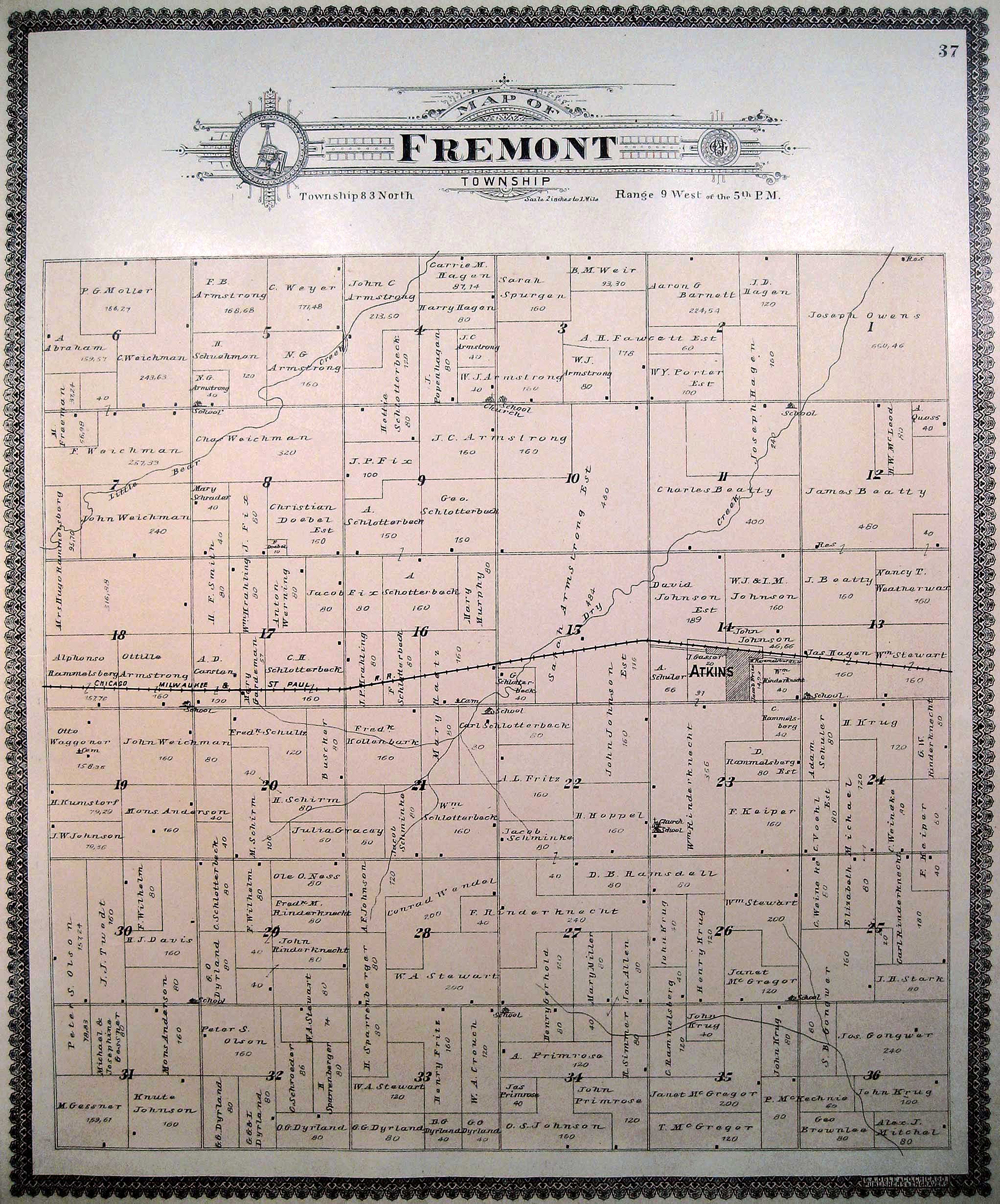
| FIX FAMILY | Pioneer | Fremont | 8 | 42.019°N | -91.925°W | Destroyed | |
| GARRISON | Jackson | 32 | 42.137°N | -92.149°W | Partial listing | ||
| GNAGY (River Brethren) | Monroe | 28 | 42.142°N | -92.242°W | Partial listing | ||
| GREENWALT | Cedar | 27 | 42.226°N | -92.104°W | Partial listing | ||
| GREENWOOD (Johnson) | Pioneer | Canton | 1 | map | |||
| HOLY CROSS | Kane | 13 | 41.996°N | -92.183°W | Partial listing Complete listing | ||
| HOMER BIG GROVE | Pioneer | Big Grove | 18 | USGS 1904 |
42.087°N | -92.182°W | Partial listing |
| HOUGHTON | Pioneer | Homer | 8 | 42.109°N | -92.280°W | Partial listing | |
| Every gravestone | |||||||
| INDIAN MOUNDS | Pioneer | Big Grove | 10 | 42.108°N | -92.107°W | ||
| INMAN FAMILY | historical | Eden | 11 | USGS 1875 1904 |
Burials moved to First Eden |
||
| INTERNATIONAL | Leroy | 19 | 41.898°N | -92.180°W | Partial listing | ||
| IRVING | Kane | 31 | 41.951°N | -92.280°W | Partial listing Complete listing |
||
| KEYSTONE | Kane | 14 | 41.994°N | -92.217°W | Partial listing | ||
| KIRCHNER | Pioneer | Homer | 23 | USGS 1875 1904 |
42.07269°N | -92.20274°W | Complete listing |
| KISLING (Wilmington) | Polk | South 3 | 42.205°N | -91.890°W | Partial listing ~ Plat Map ~ |
||
| Selected surnames | |||||||
| Selected surnames | |||||||
| LARUE (Quaker) | Pioneer | Big Grove | 28 | 42.057°N | -92.144°W | Complete listing | |
| LUTHERAN (Luzerne) | Iowa | 24 | 41.899°N | -92.185°W | Partial listing | ||
| Partial listing | |||||||
| MAPLEWOOD | Taylor | 18 | 42.170°N | -92.049°W | Partial listing | ||
| McBROOM | Pioneer | Benton | 24 | 42.155°N | -91.848°W | Complete listing | |
| MOUND | St. Clair | 23 | 41.897°N | -91.972°W | Partial listing | ||
| Mt. AUBURN | Cedar | 23 | 42.253°N | -92.090°W | Partial listing | ||
| Partial listing | |||||||
| Mt. PLEASANT (Beatty) | Canton | 4 | 1904 |
42.118°N | -91.896°W | Partial Listing | |
| NORWAY | Florence | 17 | 41.910°N | -91.928°W | Partial listing | ||
| OAK HILL | Iowa | 21 | USGS |
41.900°N | -92.255°W | Partial listing ~ Plat Map ~ |
|
| OAKWOOD (East & West) | Canton | 10 | USGS |
42.098°N | -91.888°W | Partial listing | |
| PARKER'S GROVE | Canton | 28 | USGS 1904 |
42.0555°N | -91.9035°W | Partial listing | |
| PETTIT HILL | Pioneer | Taylor | 10 | 42.18473°N | -91.99638°W | Known Burials | |
| PLEASANT HILL (Black's) | Leroy | 26 | 41.886°N | -92.085°W | Partial listing Complete listing |
||
| PLUM GROVE | Pioneer | Taylor | 25 | USGS 1904 |
42.142°N | -91.967°W | Partial listing |
| PRAIRIE LUTHERAN (Eldorado or Thompson) |
Pioneer | Eldorado | 32 | 1875 1904 |
41.963°N | -92.028°W | Known Burials |
| PRAIRIE U. B. (DeWalt) | Pioneer | Taylor | 35 | 42.124°N | -91.975°W | Complete listing ~ Plat Map ~ |
|
| PRATT CREEK | Jackson | 4 | 42.210°N | -92.130°W | Partial listing | ||
| RAETZ MEMORIAL | Fremont | 16 | 41.993°N | -91.898°W | Partial listing | ||
| RAMPTON | Monroe | 8 | 42.1866°N | -92.2612°W | Partial listing | ||
| Partial listing | |||||||
| RANSTEAD (Luzerne) | Pioneer | Leroy | 17 | USGS 1904 |
41.911°N | -92.087°W | Complete listing |
| REDMAN | Kane | 30 | 41.971°N | -92.292°W | Partial listing | ||
| SALEM | Eldorado | 17 | 41.993°N | -92.042°W | Partial listing | ||
| SPENCER'S GROVE | Polk | 2 | 42.284°N | -91.865°W | Partial Listing | ||
| SPRINGER FAMILY | Pioneer | St. Clair | 36 | 1872 | Destroyed | ||
| St. JOHN'S LUTHERAN | Eldorado | 16 | 41.993°N | -92.010°W | Partial listing | ||
| St. JOSEPH'S CATHOLIC | Monroe | 18 | 42.172°N | -92.298°W | Partial listing | ||
| Partial listing (Off Site) | |||||||
| St. MARY'S CATHOLIC | Polk | 14 | 42.262°N | -91.869°W | Partial listing | ||
| St. MARY'S CATHOLIC | Taylor | 18 | 42.168°N | -92.048°W | Partial listing | ||
| St. MICHAEL'S (Catholic) | Florence | 17 | 41.909°N | -91.927°W | Partial listing | ||
| St. PATRICK'S & St. PAUL'S (Catholic) |
St. Clair | 23 | 41.899°N | -91.973°W | Partial listing | ||
| Partial listing | |||||||
| St. STEPHEN'S LUTHERAN | Fremont | 23 | 41.982°N | -91.872°W | Complete listing | ||
| STRINGTOWN | Pioneer - historical |
Leroy | 2 | 1875 |
41.948°N | -92.086°W | Destroyed |
| TWOGOOD | Pioneer | Homer | 31 | 42.050°N | -92.280°W | Known Burials | |
| UNIDENTIFIED | historical | Monroe | 31 | 1872 1875 |
Destroyed | ||
| URBANA | Polk | 35 | 42.221°N | -91.866°W | Partial listing | ||
| Surname index | |||||||
| URMY (Yankee Grove) | Pioneer | Monroe | 15 | 42.172°N | -92.228°W | Legible stones | |
| VAN METRE (Bishop Grove) | Pioneer | Union | 32 | USGS |
41.9615°N | -92.1515°W | Partial listing |
| Partial listing | |||||||
| WAGNER | historical | Fremont | 19 | 1901 |
41.989°N | -91.946°W | Destroyed |
| WRIGHT | Pioneer | Iowa | 17 | 41.914°N | -92.265°W | Complete listing | |
|
|