 |
|
 |
|
| Township | Sec. | Cemetery Name / Also Known As | Status | Maps | Latitude | Longitude |
| Benton | 19/20 | Benton City | historical | USGS | 42.158°N | -91.934°W |
| 32 | Cantonwine Family | historical | 1885 | |||
| 24 | McBroom | 42.155°N | -91.848°W | |||
| Big Grove | 2 | Big Grove | USGS |
42.109°N | -92.087°W | |
| 10 | Indian Mounds | 42.108°N | -92.107°W | |||
| 18 | Homer Big Grove | USGS 1904 |
42.087°N | -92.182°W | ||
| 28 | Larue / Quaker | 42.057°N | -92.144°W | |||
| Bruce | 31 | Brown (Herb) | USGS 1904 |
42.2163°N | -92.2797°W | |
| 36 | Fairview | 42.214°N | -92.201°W | |||
| Canton | 1 | Greenwood | map | |||
| 4 | Mt. Pleasant / Beatty | 1904 |
42.118°N | -91.896°W | ||
| 10 | Oakwood (East & West) | USGS |
42.098°N | -91.888°W | ||
| 13 | Crawford | USGS 1904 |
||||
| 28 | Parker's Grove | USGS 1904 |
42.0555°N | -91.9035°W | ||
| Cedar | 9 | Engledow | 42.269°N | -92.133°W | ||
| 23 | Mt. Auburn | 42.253°N | -92.090°W | |||
| 27 | Greenwalt | 42.226°N | -92.104°W | |||
| Eden | 2 | First Eden / East Eden | 42.109°N | -91.984°W | ||
| 11 | Inman Family | interments moved to First Eden |
USGS 1875 1904 |
|||
| 17 | Beller / Eden #2 / Lutheran | USGS 1904 |
||||
| Eldorado | 16 | St. John's Lutheran | 41.993°N | -92.010°W | ||
| 17 | Salem | 41.993°N | -92.042°W | |||
| 32 | Prairie Lutheran / Eldorado /Thompson | 1875 1904 |
41.963°N | -92.028°W | ||
| Florence | 17 | Norway | 41.910°N | -91.928°W | ||
| 17 | St. Michael's | 41.909°N | -91.927°W | |||
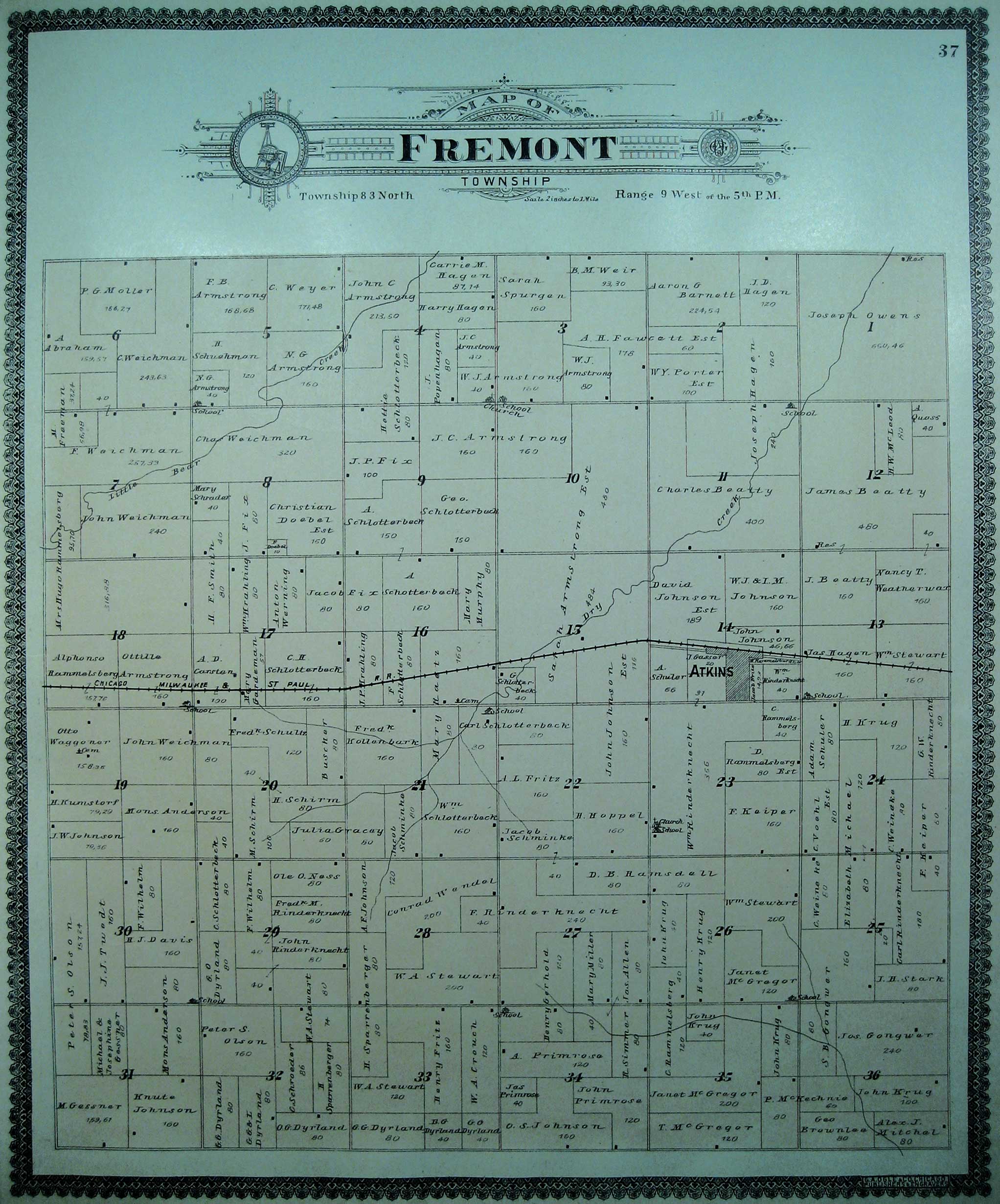
| Fremont | 8 | Fix Family | historical | 42.019°N | -91.925°W | |
| 16 | Raetz Memorial | 41.9925°N | -91.8974°W | |||
| 23 | St. Stephen's Lutheran | 41.982°N | -91.872°W | |||
| 19 | Wagner | historical | 1901 |
41.989°N | -91.946°W | |
| Harrison | 11 | Bear Creek (East & West) | 42.270°N | -91.979°W | ||
| Homer | 8 | Houghton | 42.109°N | -92.280°W | ||
| 23 | Kirchner | USGS 1875 1904 |
||||
| 31 | Twogood | 42.050°N | -92.280°W | |||
| Iowa | 17 | Wright | 41.914°N | -92.265°W | ||
| 21 | Oak Hill | USGS |
41.900°N | -92.255°W | ||
| 24 | Lutheran (Luzerne) | 41.899°N | -92.185°W | |||
| 28 | Beal | 41.890°N | -92.254°W | |||
| Jackson | 4 | Pratt Creek | 42.210°N | -92.130°W | ||
| 16 | Carlisle Grove | 42.173°N | -92.139°W | |||
| 32 | Garrison | 42.137°N | -92.149°W | |||
| Kane | 13 | Holy Cross | 41.996°N | -92.183°W | ||
| 14 | Keystone | 41.994°N | -92.217°W | |||
| 30 | Redman | 41.971°N | -92.292°W | |||
| 31 | Irving | 41.951°N | -92.280°W | |||
| Leroy | 2 | Stringtown | historical | 1875 |
41.948°N | -92.086°W |
| 17 | Luzerne / Ranstead | USGS 1904 |
41.911°N | -92.087°W | ||
| 19 | International | 41.898°N | -92.180°W | |||
| 26 | Pleasant Hill / Black's | 41.886°N | -92.085°W | |||
| Monroe | 8 | Rampton | 42.187°N | -92.261°W | ||
| 15 | Urmy / Yankee Grove | 42.172°N | -92.228°W | |||
| 18 | St. Joseph | 42.172°N | -92.298°W | |||
| 28 | Gnagy / R. B. | 42.142°N | -92.242°W | |||
| 31 | Monroe | historical | 1872 1875 |
|||
| Polk | 2 | Spencer's Grove | 42.284°N | -91.865°W | ||
| 14 | St. Mary's | 42.262°N | -91.869°W | |||
| 35 | Urbana | 42.221°N | -91.866°W | |||
| 35 | Urbana Memorial | 42.220°N | -91.862°W | |||
| So. 3 | Kisling | 42.205°N | -91.890°W | |||
| So. 4 | Cox | 42.199°N | -91.910°W | |||
| St. Clair | 23 | Mound | 41.897°N | -91.972°W | ||
| 23 | St. Patrick's & St. Paul's | 41.899°N | -91.973°W | |||
| 36 | Springer Family | historical | 1872 | |||
| Taylor | 10 | Pettit Hill | 42.18473°N | -91.99638°W | ||
| 18 | Maplewood | 42.170°N | -92.049°W | |||
| 18 | St. Mary's | 42.168°N | -92.048°W | |||
| 22 | Evergreen | 42.161°N | -92.009°W | |||
| 25 | Plum Grove | USGS 1904 |
42.142°N | -91.967°W | ||
| 35 | Prairie United Brethren / DeWalt | 42.124°N | -91.975°W | |||
| Union | 5 | Bender | 42.036°N | -92.154°W | ||
| 27 | Calvary / Kelly / Catholic | 41.964°N | -92.114°W | |||
| 32 | Van Metre / Bishop Grove | USGS |
41.9615°N | -92.1515°W |
|
|