|
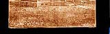
RINGGOLD COUNTY BEFORE IOWA WAS A STATE
HONEY WAR
 A heated dispute broke out along the Missouri and Iowa border when a sheriff from Missouri attempted to collect taxes from residents
who were living in what they believed to be Iowa Territory but was a strip of land Missouri claimed to be theirs. This strip of land had previously
been a source of much contention with settlers believing that they were residents of Missouri, a slave state, then leaving their homesteads
when discovering that they were residing in Iowa, a non-slave territory. This strip of land, approximately nine to thirteen miles wide along the border,
became a hot bed of controversy after the 1837 Missouri legislature ordered that the boundary line be resurveyed, resulting in Missouri's conclusion
that the actual boundary line was several miles north of what had established and recognized for years. When the Missouri sheriff came around
to collect what he felt was justly Missouri taxes, the settlers refused to pay, believing that they were residents of the Iowa Territory and consequently
were being unfairly taxed.
A heated dispute broke out along the Missouri and Iowa border when a sheriff from Missouri attempted to collect taxes from residents
who were living in what they believed to be Iowa Territory but was a strip of land Missouri claimed to be theirs. This strip of land had previously
been a source of much contention with settlers believing that they were residents of Missouri, a slave state, then leaving their homesteads
when discovering that they were residing in Iowa, a non-slave territory. This strip of land, approximately nine to thirteen miles wide along the border,
became a hot bed of controversy after the 1837 Missouri legislature ordered that the boundary line be resurveyed, resulting in Missouri's conclusion
that the actual boundary line was several miles north of what had established and recognized for years. When the Missouri sheriff came around
to collect what he felt was justly Missouri taxes, the settlers refused to pay, believing that they were residents of the Iowa Territory and consequently
were being unfairly taxed. 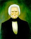 The settlers appealed to Iowa Territory Governor Robert LUCAS who upheld their position in the matter. The situation became hot and testy when Missouri
Governor Lilburn W. BOGGS came to the defense of his tax collectors. Governor LUCAS (1781-1853), well-known for his temper, wasn't about to back down and
relinquish claim of the land to Missouri.
The settlers appealed to Iowa Territory Governor Robert LUCAS who upheld their position in the matter. The situation became hot and testy when Missouri
Governor Lilburn W. BOGGS came to the defense of his tax collectors. Governor LUCAS (1781-1853), well-known for his temper, wasn't about to back down and
relinquish claim of the land to Missouri.
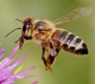
In the strip of land were several hollow trees where honey bees had established colonies. The settlers residing in the area valued these trees for the honey
($.37 a gallon) and the beeswax. Then, a Missouri man, whose name has been lost over the decades, cut down three of the hollow trees. The Territory of Iowa
tried the Missourian absentia, found him guilty, and fined him $1.50. This action inflamed the Missourians. They had been established as a state since 1821. With the promise of Iowa becoming a state in the near future, this was
all it took to stir up the controversy over the Iowa-Missouri border issue once again. Joseph BROWN from Missouri resurveyed the land in 1837, which no one acknowledged. Major Albert LEA, a federal surveyor, was called in to conduct his own survey
in 1838. Major LEA's conclusion was there could be possibly four boundary lines, based upon his survey and interpretations of historical data available to him. Governor
BOGGS, also known for his temper, proclaimed in August of 1839 that BROWN's 1837 survey was the true border. In response, Governor LUCAS authorized the legal
arrest of anyone from Missouri who attempted to exercise his authority in "the seat of excitement." Meanwhile, Missouri's Clark County sheriff Uriah "Sandy" GREGORY obeyed his orders to enter into the contested land and collect taxes, which included taxes on bee
trees. Approximately 1,200 residents met up with Sheriff GREGORY and demanded that he go back home to Missouri. Outnumbered, Sheriff GREGORY complied.
Upon returning back home, Sheriff GREGORY dispatched a letter to Governor BOGGS, stating, "I am at a loss what to do the Citizens of that territory two-thirds of which is hostile . . .
declare if I pretend to use any authority which I am invested by the State of Missouri, they will take me by force and put me in confinement."
Governor BOGGS replied, ordering Sheriff GREGORY to return and collect the taxes. NOTE: Governor BOGGS would later sign into law an order which banished the Mormons
from the State of Missouri, forcing their exile to Nauvoo, Illinois. Beleaguered Sheriff GREGORY returned and was promptly incarcerated in Burlington. The citizens of Burlington treated the sheriff well, allowing him to roam around town but
refused to allow him to return home By this time it was December when both sides prepared for what seemed eminent - war. Declaring that this dispute "might ultimately lead to the effusion of blood," Governor LUCAS
called for 1,200 men who adopted the war cry of "Death to the Pukes." They were placed under the command of four generals, nine general
staff officers, 40 field officers, and 83 company officers. They also drank a considerable quantity of whiskey. Missouri attempted to raise 2,200 men but less than half reported
for duty. The gathered militia on both sides were a rag-tag assortment of men, each one reporting for duty in whatever uniform he felt was worthy of the occasion. They were armed with whatever
was handy, rifles, muskets, shotguns, pistols, long swords, short swords, and one Missourian with a sausage stuffer.
Fortunately, Missouri's Clark County officials exhibited some common (and sober?) sense by sending a delegation to the Iowa Territory with the goal of working out a truce. After some
discussion, both sides arrived upon a classical solution to the problem at hand. They would let the Federal government find a resolution. Hence, both sides told their militia to go
back home. The Lewis County, Missouri, militia was not pleased to receive their orders. They had spent two nights huddled in the snowy winter cold without tents or enough blankets to go around.
They did, however, have plenty of whiskey with one company bringing five of their six wagons of provisions filled with the drink. Diligent, inflamed, and intoxicated, the men wanted
to shoot something. So they cut off a haunch of venison, labeling one half "Gov. BOGGS" and the other half "Gov. LUCAS." The men took aim and shot up the venison, afterwards holding
a mock funeral. The U.S. Supreme Court deemed that the old boundary line (prior to the dispute) was the true boundary line and consequently ordered surveyors out to mark the line. In 1850, state
boundary markers were set in place at 10 mile intervals. Over the course of time most of the markers have vanished with one still remaining on the LONGNECKER farm.
NOTE: Out of all the materials I've researched, I've never found a soldier from Ringgold County who
was involved with the Honey War - EXCEPT for Luke SHAY of rural Maloy.
SOURCES:
STORIES of IOWA for Boys and Girls, Chapter XXXII, "The Iowa-Missouri Boundary War" http:..iowagenweb.org/history/soi/soi32.htm
VANCE, Joel M. "War Was NEVER So Sweet" Missouri Conservationist Online, Vol. 58 No. 1, Jan. 1996. http://mdc.mo.gov/conmag/1997/01/50.htm
Ringgold County History Complied and written by the Iowa Writers' Program of the Work Projects Administration in the State of Iowa, Sponsored
by Ringgold County Superintendent of Schools, Mount Ayr, Iowa. 1942.
Written &Submitted by Sharon R. Becker, 2007; updated note April of 2010
HISTORY INDEX

|