 Cemeteries  WPA, 1930's WPA, 1930's
 Surnames
Search Photos
Add New Photos
Surnames
Search Photos
Add New PhotosOur Cemetery Records have been compiled by many volunteers using; Cemetery Indexes, Obituaries, Death Records, Family Records, Gravestone Photos, W.P.A. Cemetery Surveys and Researcher's Personal Records. For updates, please contact our County Coordinator. | |||
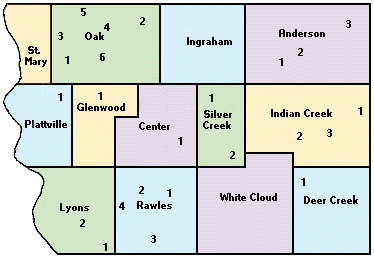
| Cemetery | Location | Available Photos | |
| Anderson | Cotten-Granteer | #1, Section 36. | |
| Henderson Farm Creek | #3, Carson, Section 11. | ||
| Russell Burials/Sayler's Farm | Henderson, Section 19 | ||
| Wesley Chapel | #2, Emerson, Section 30. | ||
| Center | Bomar Family burials | Section 17. | |
| County Farm | |||
| Hillsdale and Louden | #1, Originally a Mormon burying ground known as Loudon. | ||
| Deer Creek | South Grove | Imogene, Section 6. | |
| Glenwood | Glenwood | #1, Section 2 & 11. | |
| Glenwood Catholic | East end of Glenwood Cemetery, | ||
| Glenwood State School | |||
| Indian Creek | Emerson | #1, Emerson, Section 13. | |
| Hastings or Mennonite | #2, Emerson, Section 25. | ||
| North Grove | |||
| Wearin | Section 14. | ||
| Ingraham | Silver City | Section 23. | |
| Lyons | Mackey | #1, Tabor, Section 36. | |
| Van Eaton | #2, Rock Bluff, Section 21. | ||
| Waubonsie | Section 24. | ||
| Oak | Gowens/Turner | #1, Pacific Junction, Section 28. | |
| Mineola | #2, Mineloa, Section 8. | ||
| Salem/Plumer Settlement (off-site) | #3, Council Bluffs, Section 2. | ||
| Saar's Field | Council Bluffs South. | ||
| Saint Boniface | #4, Mineloa, Section 11. | ||
| Wall | #5, Sections 17 & 20. | ||
| West Liberty | #6, Pacific Junction, Section 26. | ||
| Plattville | Godsey Cemetery | 4 miles north of Pacific Junction. | |
| Pacific Junction/Martin Chapel | #1, Pacific Junction, Section 4. | ||
| Rawles | Fairview | #1, Tabor, Section 16. | |
| Linville Farm | Tabor | ||
| Pleasant Hill (Estes) | #2, North of Tabor, Section 20. | ||
| Tabor | #3, Tabor, Section 33. | ||
| Saint Marys | Evan Lloyd Cemetery | Pacific Junction, Southwest corner, Section 31 (Abandoned). | |
| Saint Marys | Council Bluffs South | ||
| Silver Creek | East Liberty | #1, Malvern, Section 7. | |
| Malvern | #2, Section 32. | ||
| White Cloud | Parker | Tabor North East | |
| |||
Page updated February 21, 2025 by Karyn Techau
Please read the IAGenWeb Terms, Conditions & Disclaimer
~ all of which applies to the complete Mills County IAGenWeb website. ~
2025 - Mills County IAGenWeb