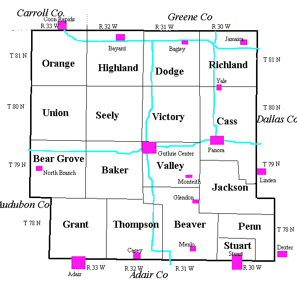
Maps
- 1875 Illustrated Historical Atlas – Guthrie County
- 1899 Sanborn Fire Insurance Map of Guthrie Center, Guthrie County
- Topographic Map 1904 of Guthrie County
- 1910 Huebinger's Map & Guide for River to River Road
- 1912 Huebinger's Map & Guide for Panora Speedway
- 1915 Huebinger's Pocket Guide: 1)Map of Guthrie Co. (Offsite); 2)Towns and Advertisers
- 1917 Atlas and Plat Book Guthrie County (Kenyon) (Offsite)
- 1930 Plat Book of Guthrie County (Hixson) (Offsite)
- c. 1992 Map of Guthrie Co. (911 addresses)
Cities/Towns by Township:
Bear Grove -- Bear Grove, Graceville, North BranchBeaver -- Glendon, Guthrie, Menlo, Ridgeway
Cass -- Panora, Wilsons, Yale
Center -- Glendon
Dodge -- Bagley, Herndon, Jamaica
Grant -- Adair (north edge only; rest in Adair Co.)
Highland -- Allenville, Bayard, Dodge, Wilkins
Jackson -- Allen, Dale City, Fairview, Harbor Station, Morrisburg
Orange -- Ava, Brushy Valley, Erastus, TuttleGrove
Penn -- West Milton
Richland -- Advance, Jamaica, Sedalia, Van Nest
Seeley -- Maida, Wichita
Stuart -- Pennsburg, Stuart, Macksville
Thompson -- Casey, Dalmanutha, Gopher Station, Safeside, Wilmington
Union -- Harrison, Nelson
Valley -- Guthrie Center, Monteith
Victory -- Fansler (Fanslers/ Stringtown), Leadville, Moffitt's Grove
History of Abandoned Towns


