
|
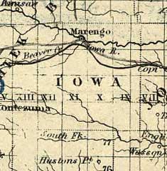 |
1857 Map - Iowa County detail from Map of the Iowa Central
Air Line Rail Road and its connections; J.H.
Colton & Co.; Created/Published New York, c1857.
Detailed township map of the north-central states indicating drainage, cities
and towns, townships, county boundaries, the road and railroad networks, and in
blue overprint the connections with the Iowa Central line.
Entered according to act of Congress in the year 1857.
|
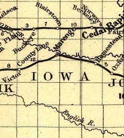 |
1868 Map - Iowa County detail from Map showing the Iowa
& Missouri State Line Railroad and its connections.
G.W. & C.B. Colton & Co.; Created/Published New York, 1868.
Township and county map of the northern United States showing drainage, cities
and towns, and the railroad network emphasizing the main line.
|
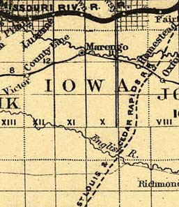 |
1871 Map - Iowa County detail from Map showing location
of lands belonging to the Iowa Rail Road Land Company Iowa Falls, and Sioux City
R.R. Land Company Sioux City, and Pacific Land Company & Elkhorn Land Company,
J. T. McAlvin, Del. I.R.R. Land Department, Cedar Rapids, Iowa, 1871.
G.W. & C.B. Colton & Co.; Created/Published New York, 1871.
Map of the midwestern states showing drainage, township and counties, land grants,
railroads with named lines. Includes geographical description and advertising.
Entered according to act of Congress in the year 1857
|
From the
Library of Congress Geography and Map Division, a.ka., Library of Congress American
Memories. See Copyright and Restrictions at this link. Resized and manipulated for this
site by Stephen D. Williams 2005.
|