 |
|
 |
|
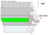 |
Year: 1837 and 1843 Source: Development of the State of Iowa Publisher: Gold Bug Historic Maps and Software IMAGE SIZE: 17 KB |
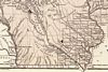 |
Year: 1842 - 1845 (1845 edition with some changes to the maps and the addition of color) Source: Morse's North American Atlas Publication Author: Morse, Sidney E. (Sidney Edwards), 1794-1871 Published by: Harper & Brothers IMAGE SIZE: 148 KB |
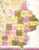 |
Year: 1845 Source: Tanner's New Universal Atlas (Henry S. Tanner) Publisher: Tanner issued this atlas first in 1836 with engraved maps, then it was taken over by Carey and Hart in 1843 and converted by them to lithographic maps in 1845. IMAGE SIZE: 138 KB |
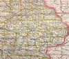 |
Year: 1890 Source: Map of Iowa Publisher: Rand McNally, Chicago IMAGE SIZE: 441 KB |
|
|