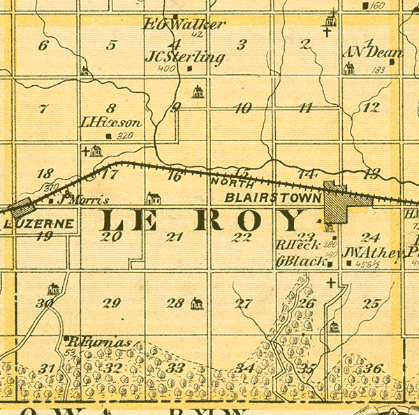
The USGenWeb Project
Benton County, IAGenWeb Project
HOME SEARCH WHAT'S NEW SITE MAP
The IAGenWeb Project

Benton County, Iowa
Leroy Township 11 W Range 82 North
A.T. Andreas' Illustrated Historical Atlas of the State of Iowa, 1875

Le Roy Twp. Map

--------------------------------------------------------------
 Section   Name                                        Acres
--------------------------------------------------------------
       1   A.N. Dean                                   183
       2   Stringtown / Evangelical Church & Cemetery         
       4   E.G. Walker                                  42
       4   J.C. Sterling                               400    
       8   L. Hixon                                    320
      17   Ranstead Cemetery                                   
      18   J. Morris                                   310    
      23   R. Heck                                     280    
      23   G. Black                                    180    
      24   J.W. Athey                                  456 1/2
      26   Pleasant Hill / Black's Cemetery                   
      31   R. Furnas                                    53
--------------------------------------------------------------
City Map of Blairstown

Kane Township    Monroe Township

1875 County Map  1875 Name Index

Transcribed by Sue Soden.
Copyright © 2007 by Sue Soden.
All Rights Reserved.


If you note any corrections, changes, additions, or  find any links provided on this web site that are
not  functioning properly please notify  John Shuck, your Benton County Website Coordinator.

Copyright © 1997-2024. This web site was created solely for the
use and benefit of the IAGenWeb Project
a part of the USGenWeb Project.
All Rights Reserved.