 |
Early Days at Council Bluffs
Maps and Illustrations
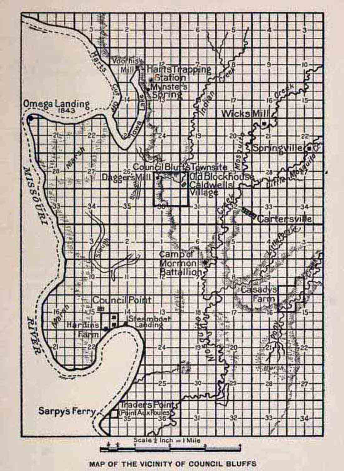
MAP
OF THE VICINITY OF COUNCIL BLUFFS
This map, or diagram, has been prepared from the plats of surveys made
in 1851-1852 by the United States Government, and from other sources of
information deemed reliable. It shows the west two-thirds of each of
the townships 74 and 75, range 43, and all of each of the fractional
townships 74 and 75, range 44,
All points laid down thereon, except Camp of Mormon Battalion, Hart's
Trapping Station. Caldwell's Village, and Omega Landing — 1843, are
fixed in accordance with the records of the General Land Office. The
locations of the Old Blockhouse and Caldwell's Village have been
indicated from records found in the Indian Bureau and War Department,
and various concurrent sources of information. The locations of the
Omega Landing and Hart's Trapping Station are shown as supposed to be
from historical writings found to have bearing in relation thereto. The
Camp of the Mormon Battalion is shown to be located as indicated upon
information by Rev. Henry De Long, and by writings of Colonel Thomas L.
Kane and others made at the time. The authorities are more fully
described in the text of the book.
SKETCH MAP OF
POTTAWATTAMIE COUNTRY
The Sketch Map from which this diagram is taken — slightly larger than
this copy — was made at or near Council Bluffs in 1837 by Dr. Edwin
James, the first Sub-Agent in charge of the Pottawattamie Indians in
Iowa, to accompany the first official report (August 11, 1837,)
submitted by him to General William Clark, Superintendent
of Indian Affairs at St. Louis, and was by the latter forwarded to the
Secretary of War, then in charge of Indian Affairs, with a letter dated
September 20, 1837.
It will be remembered that at the time the sketch map was made no
survey of any character had been made of the country to which the map
relates; that Dr. James made the drawing entirely from his own
observation and from information derived from trappers and others who
had partially explored the region. Taking into considera- tion these
facts the map is wonderfully accurate.
The original of this map is in the office of the Commissioner of Indian
Affairs, Washington, D. C. (Pottawattamie File "C"). Notice the name
"Welch's Creek" applied to what is now called Pigeon. It was named
"Indian Knob Creek" by Lewis and Clark, and is shown on Nicollet's map
of 1843 as "Gopher Creek."
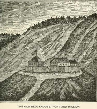
THE OLD
BLOCKHOUSE, FORT AND MISSION
(Picture by George Simon.)
This is a reproduction of an illustration accompanying an article by
Hon. D. C. Bloomer, published in Annals of Iowa in 1896 (3d Series,
Volume 2, page 594), the cut having been made from a painting said to
have been done by George Simons, from memory.
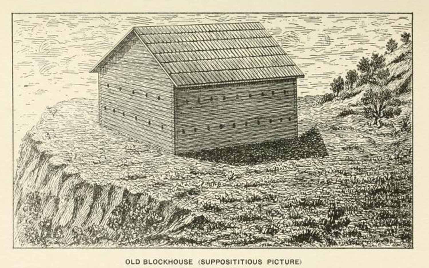
THE OLD
BLOCKHOUSE
(Supposititious Picture)
By this picture attempt is made to depict the old blockhouse as it
probably appeared when completed by Captain D. B. Moore in 1837,
together with the blunt nose of bluff whereon it stood. No portholes
are shown because there was no reason why any should have been
originally provided. United States troops did not ordinarily employ
cannon in the control of the Indians at that early day, and it is not
probable that the same were furnished the Pottawattamies for their
protection. The building was a simple hewn-log structure, twenty-four
feet square, without openings on the north and west sides except
loopholes for small-arms fire. After it came into the possession of the
Jesuit missionaries small windows were cut in those sides which were
afterward taken by some to have been portholes for cannon fire.
The folly of such belief is apparent upon consideration of the size and
character of the building, and what would probably have happened to the
occupants had a large gun been fired from the inside. No frontier
blockhouse, even at the largest of the government military posts,
appears to have been constructed with a view to firing cannon from
within. When cannon were provided for such posts they were usually
mounted outside the buildings in bastions especially designed for the
purpose.
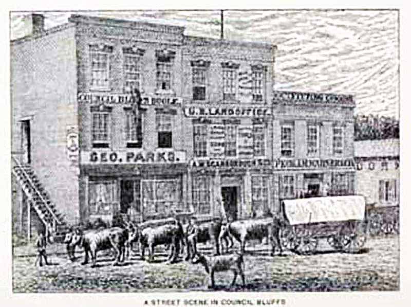
A STREET SCENE
IN COUNCIL BLUFFS
This is a picture of the Phoenix Block, north side of Broadway at the
corner of what was originally Hyde, subsequently Madison, now North
First Street. It was one among the first brick business buildings
erected in the city. At the extreme right is seen the weatherboarded
side of the old log store of CoRNELros Voorhis, a portion of the sign
being shown.
The "prairie schooner" is drawn by a typical Mormon team — three yoke
of oxen and one of cows. In the foreground is a calf. The emigration
authorities of the Church of Latter Day Saints required that each team
should comprise not less than three yoke of cattle, one of which must
be cows. The owner of the team here depicted more
than fulfilled the terms prescribed. It will be observed that, in
addition to the full team, he has an additional bovine of some
description on the off-side of one of the pairs in the team.
The drawing from which the cut here shown was produced is from a
photograph now in the possession of Mrs. L. S. Hills, of Salt Lake
City, Utah, whose husband (Lewis S. Hills) was the last democratic
Register of the United States Land Office at Council Bluffs, and who
emigrated to Salt Lake in 1861, where he died, July 21, 1915.
|
|
|
|