1838-1938

| West Liberty History 1838-1938 | |

Source: One Hundred Years of History
* Commemorating a Century of Progress in the West Liberty Community * WEST LIBERTY, IOWA
LOOKING BACKWARDS This is a world of progress. History is being made day by day. Events follow each other with lightning-like rapidity, astonishing even the quick thinking men of this age. But little more than a century has passed since the territory comprising the great commonwealth of Iowa was in the peaceable possession of the red men. The Indians roamed the plains and forests at will, claiming and procuring an existence from the bounteous hand of nature. Here the deer, buffalo and fur bearing animals found habitat, and the main streams gave generously of palatable fish. The red man had no care for the morrow. No thought came to him that his possessions would ever be disturbed by the paleface. So he continued in his dreams. He knew not of the future and cared less. But the time was coming, was upon him, and he was called upon to make room for a stranger and a more progressive race of men; when the fair land, that was his birthright, and his hunting grounds, resplendent with gorgeous flowers and emerald sod, must yield to the husbandman.
The wonderful transformation that has taken place can scarcely be realized even by those who have been most active in the work. The Pioneer is gone. No longer can we call upon him to tell us of the past and the exciting days three-quarters of a century ago. Even the children of those Pioneers are soon to be numbered with those who have passed to the Great Beyond. So we feel called upon at the time of this Centennial Celebration of West Liberty, Iowa, to record as far as is possible a true and correct history in a more or less story form of the exact happenings of this community as we find them in printed form, from letters and statements in the hand of the Pioneers, and from the lips of those still with us who are well passed the three score and ten years.
As we sit in our easy chair of this day it is hard to comprehend the humble log-cabin of yesterday, the tall prairie grass, with the fleet-footed deer and other wild game that our ancestors were so accustomed to see. Evidences of progress are on every hand as one wends his way across this beautiful state. Manufacturing plants have sprung up hither and yon; schools, colleges, vast institutions of instruction and learning, magnificent edifices for religious worship point their spires heavenward, lodges and societies everywhere, villages have grown into towns and then into cities and these are so interwoven with telegraph, telephone, electric light, railroads, and paved roads that it is hard to comprehend that the tallow-dip of yesterday has been replaced by the electric light of today. These many changes are not alone for the towns and cities, as the rural districts of today are equally equipped with all that the cities can boast of.
As an introduction to the history of our community, we will briefly note a few of the events in the early history of the Upper Mississippi. Probably the first white men who beheld the region of country now included in the State of Iowa, were Father Marquette and Joilet, the devout Catholic missionaries, who, in June, 1673, discovered the Upper Mississippi, just 132 years after the Lower Mississippi had been discovered by DeSoto and seven years subsequent to Father Hennepin and two followers who descended the Illinois river to the Mississippi and then explored the latter stream as far up as the lakes which constitute its source.
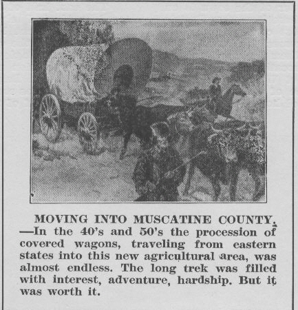
In 1803 the United States purchased Louisiana from France. In 1805 Lt. Pike under authority of the U. S. Government explored the Mississippi to its source. In 1816 Col. Lawrence built Fort Armstrong on Rock Island. In 1823 the steamboat, Virginia, of Wheeling, was the first steamer on the Upper Mississippi. At the Treaty of September 21st,1832, which closed the Black Hawk War, Gen. Scott, a commissioner on part of the U. S., purchased from the Sac and Fox Indians that tract of country distinguished as the Iowa District, but possession was not given until the first day of June, 1833. It was then but a short time until the white man made his appearance. Just who the first settler was has more or less been in dispute, but for many years Benjamin Nye was given the credit of the First Settler in Muscatine County, although the Western Historical Society lists Err Thornton and Benjamin Nye as settlers in 1833.
Each succeeding year brought more and more of the Pioneers to Iowa and according to the History of Wapsinonoc Twp. and West Liberty as published by Asa Gregg in 1878 it states, " The First Settlement was made in the fall of 1836 and the first white woman that made a permanent home here is now a respected inhabitant of this village. I allude to Mrs. Mary Nyce, who is, at all events, entitled to the honor of being the oldest inhabitant living here. There were several other families wintered here that winter, among them, some men by the name of Huntmann, who in the spring went to Missouri and united their fortunes with the great Mormon prophet, Joseph Smith, who was at that time making a settlement there and shortly afterward was driven out of the state."
In the spring of 1837 came William Bagley, William Corns, William A. Clark, and Asa Gregg, all of whom arrived before the middle of May. Later in the year came Galentine Gatton and Samuel Hendrickson, Henyen and Cornelious Lancaster, Nathaniel Hallock, and Frances Foot.
The first settlement was known as the " Wapsinonoc Settlement," that being the Indian name of the stream, which in their language or tongue signifies " smooth-surfaced, meandering stream or creek " and they pronounced it Wap-pe-se-no-e-noc. In 1838 the following additions were made to the settlement: George Van Horne, William Leffingwell, J. P. Van Hagen, and Robert Stuart. In 1839 came Valantine Bozarth, S. A. Bagley, Enos Barnes, James Van Horne, and Jacob Springer, John C. Lane, A. B. Phillips and John Bennet. In the same year Valantine Bozarth taught the first school in an unoccupied log cabin on the land owned by Asa Gregg in Sec. 2, and in 1843 the first regular school house was built on the same section.
William A. Clark who located on land in section 10 was the first man to plow land and plant a crop in the settlement and the first election was held in his log cabin to the south and west of the village of Liberty and at which, it is believed, every legal voter exercised his right; there were just eight votes west of the Cedar River.
Galentine Gatton settled on Section 6 in 1837 and lived there until his death in 1881.
Some of the original settlers came here from Liberty, Ohio, and so it was only natural that the new village was called Liberty. It was located just a little to the north and west of the present town of West Liberty.
Liberty was laid out by Simeon A. Bagley and surveyed by George Bumgardner, the County Surveyor, in 1838. A Post Office was established the same year with Mr. Bagley as postmaster.
The first store in the village was opened by Peter Heath, and it was later used as a dinner station for the stages operating between Bloomington ( now Muscatine ) and Iowa City.
In 1855 the first locomotive wended its way westward through the corn fields where West Liberty now stands, with a farm house and a barn standing within its present limits.
West Liberty ( the new town ) was surveyed January 21st, 1856, by Peter Houtz. It was laid out by John M. Spencer, T. J. Robinson, both of Rock Island and J. W. Clark of Iowa City. The only dwelling within its limits was that of Skilman Alger, at the corner of Spencer and Fourth streets, which he had reserved when the town was laid out. The daughter of Skilman Alger married James McIntosh and his grandson John E. McIntosh, one of our attorneys, was instrumental in our procuring the present Carnegie Library.
When the new town was started many buildings were moved to it from Liberty and the second building to be built was that of Henry Null in 1858 at the corner of Third and Spencer, Pearson Alger doing the carpenter work. It was first occupied as a dwelling, later by Shaw and Bagley's drug store, and finally as the Occidental hotel. The third building built was the Star house on Third street.
The Wapsinonoc settlement soon became Wapsinonoc Township which originally consisted of all of Muscatine County west of Cedar River.
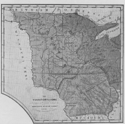
Muscatine County, Iowa, is bordered on the southeasterly side by the Mississippi River and its county seat is sometimes called the Bend City because of being located in one of the most prominent bends in that historic stream.
Probably the fairest and most fertile of all of the townships in Muscatine County is located at the extreme northwest corner of that county and bears as pretty an Indian name as can be found on the map of Iowa, being Wapsinonoc. Wapsinonoc Township is governmental township seventy-eight, North, Range four West of the Fifth Principal Meridian, which means that it is the seventy-eighth township north of a parallel running through Little Rock, Arkansas, and is the fourth township west of the Fifth Principal Meridian which crosses the county north and south two miles west of the town of Stockton, Iowa.
The town of West Liberty, Iowa, is located almost entirely on section twelve of the above governmental township. The northwest corner of section twelve is at the intersection of the roads at North Point Inn, formerly know as the site of the brick house of Major Hogue. The southwest corner of the town is on Walnut Street a short distance south of where it crosses Prairie street, or the Chesebro Road. The southeast corner is in close proximity to where the railroad bridge crosses the Wapsinonoc creek east of West Liberty, while the northeast corner is about one quarter mile north of where the old Muscatine and Iowa City road crossed the Wapsinonoc creek east of West Liberty. The center of this section is in the center line of Columbus street even with the north lines of the two school house tracts in the town. With the center of the section well borne in mind it may be well to trace the early ownership of the four quarters of the section.
The entire northeast quarter of section 12 was entered November 8th,1838 by Richard F. Barrett to whom it was later patented in 1841. While it is not the purpose to make any extensive tracing of the title it may be well to say that this quarter section was deeded from Richard F. Barrett to Robert Stuart who deeded it to William Corns, whose name is prominent elsewhere in connection with the real estate titles in the town.
The east half of the northwest quarter of section 12 was entered by Enos Barnes November 8th, 1838. It should be mentioned that Enos Barnes was the father of Simeon Barnes, Charles Barnes and Franklin Barnes, three sturdy characters of the community who will be remembered by the older residents of the town. Enos Barnes was the grandfather of our present day townsman Byron W. Barnes. This 80 acres of land was deeded in 1865 to Charles Barnes and in an early day William Maxson became the owner of his homestead tract at what is now the north end of Calhoun street.
The west half of the northwest quarter was entered on the same eventful day, November 8th, 1838 by William A. Clark to whom it was patented in 1841. He resided on the 80 acre tract as his homestead for many years, living in the house later occupied and replaced by Ernest Geertz.
The west half of the southwest quarter of the section was entered November 8th,1838 by Lois Bagley, who deeded it in 1847 to her son William A. Bagley. She took from William A. Bagley a bond in the sum of $500 to provide for her maintenance and support and for the maintenance and support of the sisters of Lois Bagley and to provide further that the younger brother of William A. Bagley should have a horse, saddle and bridle upon becoming of age.
The east half of the southwest quarter of section 12 was entered by Alexis Phelps on the same day, November 8, 1838 and he received patent on Novenber 10th, 1841. He in turn conveyed the east half of the quarter section to Louis Bagley and the deed to William A. Bagley from Louis Bagley covered the east 80 of the quarter section as well as the west 80 and the bond given from William A. Bagley to Louis Bagley covered the east 80 at the same terms as stated above.
The west half of the southeast of the section was entered by Alexis Phelps on the same day as the other tracts were entered and it was patented to Alexis Phelps on the same day as the other patents affecting the section. Alexis Phelps according to the records of Muscatine County never conveyed this 80 acres to any person and it is problematical whether he in fact owned it, or whether he bought it from the government with money furnished by William Corns, who assumed at least to deed it in 1842 to Abner Chalfant. This is a break in the chain of title that has been a torment to so many people owning property in the eastern part of the town of West Liberty.
The east half of the southeast quarter was not entered until two years after the balance of the section was entered from the government. The original entry as to this 80 acres was dated October 12th, 1840 being entered by William A. Clark and it was patented to William A. Clark November 10th, 1841. It was later, in 1850, deeded to one Sanford Dustin a minor and later sold through a guardianship proceeding.
Aside from the original governmental monuments showing the four corners and center of section 12, the first line that was established by a surveyor in West Liberty was a line running from southwest to northeast to the southwest corner of the town parallel to and at a distance of 150 feet southeasterly from Short street in West Liberty extending northeasterly to the south line of what is now Sixth street.
At the time the Chicago, Rock Island and Pacific Railway was built from Davenport to Iowa City various town sites were alloted to different people to plat and exploit. The town of Durant by Charles W. Durant and the town of Downey by Hugh D. Downey. The town of Liberty now West Liberty was bounded on the south by First street, on the north by the alley between Fourth and Fifth streets, on the west being a line 320 feet west of Clay street and on the east by the west line of Columbus street. It was platted by John W. Spencer, Thomas J. Robunson and J. Warren Clark, who later collaborated with Wiliam C. Evans, one of our resident pioneers, on the slae of lots. It is probable many of the older residents of West Liberty will recall having seen the old time ferry boats on the Mississippi river with the name of spencer plainly painted on the housing covering the paddle wheels. This man Spencer interested in these ferry boats was the man after whom Spencer street in West Liberty was named, and who shared in the prosperity caused by the coming of the railroad and the sale of the lots. Subsequent additions to the town have been platted as follows:
First Addition, Millers Addition, Morehouse Addition, Holmes and Manful Additions, West Addition, C. D. Gibson's Addition, A. Brook's Addition, Morgan's First Addition, W.L.Brooke's, Oak Park Addition and several subdivisions of outlying tracts.
The town of West Liberty was incorporated in 1868 but the following appears in the Weekly Enterprise of Feb. 22nd, 1884:
" The City Recorder has recently discovered that the town of West Liberty was never legally incorporated. There is nothing on the State records to show that our city was ever incorporated or ever wanted to be. The presumption is that the incorporation papers were sent to Muscatine and properly recorded but never reached the state office. A certified copy of the original paper has been forwarded to Senator Pliny Nichols at Des Moines, who ere this, has taken steps to rectifying the blunder."In the Weekly Enterprise of May 2nd,1884 appears : "Chapter 90, An Act to Legalize the Corporation of the Town of West Liberty, was published in the State Register of Wednesday."
Between 1866 and 1869 the town improved very little. Travel was confined to the C. R. I. and P. Ry., and the old freight house on Calhoun street was both passenger and freight depot. However in anticipation of the Burlington, Cedar Rapids and Minnesota Rail Road, to the stock of which our citizens subscribed $60,000.00, building had commenced.
From this time on, many houses were erected and the resident area was much improved as the town was growing rapidly and so in 1889 West Liberty was a thriving town of about 2000 inhabitants, well supplied with schools, churches, and mercantile establishments; and was indeed a most delightful place to live.