 |
Des Moines Township |
 |
|
|
Des Moines Township |
|
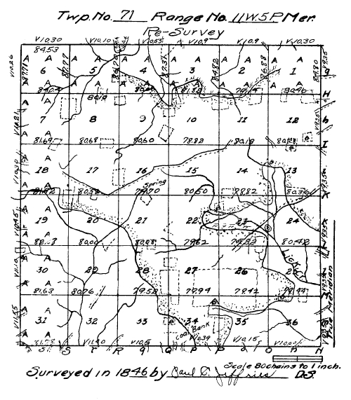
Field Notes of Township 71 N. Range 11, West of the Fifth Principal Meridian, Iowa Territory. Surveyed by Paul C.; Jeffries, Deputy Surveyor.
Commenced June 9th, 1846.
Completed June 22nd, 1846.
North Between sec. 35 & 36.
25.30 W. Oak 30 in dia.
34.75 Run 4 L N E.
40.00 Sec qr. sec. post. (sic)
Bearings:
Br. Oak 24 S 74 W 196.
Br. Oak S 37 E 1.03.
56.75 Run 5 L N E.
60.00 Enter prairie S W & N E.
80.00 Set post cor. of sec. 25 & 6 (sic - 25 & 26), 35 & 36 and made mound of earth & sod, pit 4 L S.
A black locust planted by the Inhabitants at the cor. of former survey, bear, S 25 E 118.
Land good, 2nd rate, Br. Oak, Hickory & Elm, Very Brushy, Hazel, plum, Thorn & J. Oak.
East Random between sec. 25 & 36.
27.00 Enter field N & S.
35.00 House 50 L South.
38.00 Leave field & enter brush.
48.00 Enter field N & S.
59.75 Leave same.
79.44 Intd line 90 1 (sic - 90 L) S of post. Land same.
West Corrected line Var 10° 39'.
39.72 Set qr. sec. cor.
Br. Oak 26 S 41 E 241.
Br. Oak 20 N 1 W 300.
79.44 Sec. cor.
North Between Sec. 25 & 26.
40.00 Set post qr. sec. cor & made mound of earth & sod.
Pit 4 L East.
47.00 Leave prairie N W.
69.30 Field S W.
73.00 Leave same N W.
80.00 Set post cor. of sec. 23, 24, 25 & 26.
W. Oak 22 N 74 W 20.
Hickory 10 S 65 E 50.
Land same.
June 9th, 1846.
East Random between Sect. 24 & 25.
18.90 Lick Creek 20 L S E.
64.40 Run 2 L S E.
80.40 Intd. E B 16 L S of post.
Land rolling, 2nd rate, Hickory, Br. Oak, etc.
U. G. Hazel, plum, etc.
West Corrected line Var 10° 47'.
40.20 Set qr. sec. post.
Hickory 10 N 32 W 22.
Br. Oak 8 S 7 W 30.
52.67 Elm 18 in dia.
80.40 Sec. cor.
North Between Sec. 23 & 24.
9.63 W. Oak 36 in dia.
21.50 Lick Cr. 20 L S E.
23.50 Impassable pond.
Offset:
N 60 E 3.00.
N 60 W 3.00 to line.
35.00 Territorial Road to Iowa City, N E.
40.00 Set qr. sec. post.
R. Oak 40 N 12 W 68.
R. Oak 18 N 75 E 90.
59.40 Lick creek 30 L S E.
69.00 Enter prairie N W & N E.
80.00 Set post cor. of sec. 13, 14, 23 & 24 & made mound of earth & sod.
Pit 4 l South.
Land in timber same as last mile, prairie, rolling & dry, 2nd rate.
East Random between sec. 13 & 24.
4.50 Leave prairie N W.
9.75 Lick Cr. 20 L S E.
34.60 Enter field & prairie N & S.
64.00 Leave field N & S.
Road to Fairfield.
65.00 Enter field East.
80.36 Intd. E B 14 L N.
Land level & rolling, good 2nd rate, in grove, grushy (sic - brushy), Hazel, J. Oak, Thorn, etc.
West Corrected line Var 10° 39'.
40.18 Set qr. sec. post in field and made mound of earth & sod.
Pit 4 L E.
80.36 Sec. cor.
North Between sec. 13 & 14.
20.00 Enter brush grove.
40.00 Set qr. sec. post.
J. Oak 4 N 84 E 7.
J. Oak 5 N 15 W 10.
46.25 Leave grove & enter prairie & cross run & L S E (sic - 8 L S E?).
48.00 House on right 50 L.
80.00 Set post in slough cor. of sec. 11, 12, 13 & 14. and made mound, Pit 23 L South.
East Random between sec. 12 & 13.
9.00 Road from Ottumwa to Burlington N W From East.
33.00 Enter land.
40.00 House on right.
45.00 Pass field.
54.50 Blacksmith shop & house.
60.00 House & farm on left.
80.28 Intd. line 71 L S of post. Land rolling, good 2nd rate prairie.
West Corrected line Var 11° 04'.
40.14 Set post & made mound pit 4 L E.
80.28 Sec. cor.
June 10th, 1846.
North Between sec. 11 & 12.
3.50 Road W N W.
40.00 Set qr. sec. post & made mound of Earth & Sod. Pit 4 L E.
79.00 Run 2 L N W.
80.00 Set post & made mound of earth & sod, pit 4 L S.
Cor. of sec. 1, 2, 11 & 12.
Land same.
East Random between sec. 1 & 12.
17.00 Enter field S & N.
23.25 Leave same S & N.
60.00 Enter field S & N.
74.50 Leave field E S E House N 50 L.
80.40 Intd. E B 203 L S of post.
Land same.
West Corrected line Var 11° 27'.
40.23 Set qr. sec. post & made mound of earth & sod. Pit 4 L E.
80.40 Sec. cor.
North Between sec. 1 & 2.
35.00 School house & leave prairie & enter grove N E.
40.00 Set qr. sec. post.
J. Oak 12 S 35 E 42.
J. Oak 12 N 77 W 41.
40.51 Elm 18 in dia.
86.88 Intd. N B 65 L E.
J. Oak 12 S 58 W 75.
J. Oak 8 S 68 E 60.
Land in prairie same in grove, Elm, J. Oak and Hickory, thick U. G. Hazel, Plum, etc.
North Between sec. 34 & 35.
20.00 Enter field N E.
39.50 Leave same W & enter brushy grove.
40.00 Set qr. sec. post.
Br. Oak 4 S 70 W 17.
J. Oak 4 S 19 E 16.
49.50 Run 3 L S E & leave grove N W.
50.75 Enter field E & W House N W 5.00.
80.00 Set post cor. of sec. 26, 27, 34 & 35 & made mound of earth & sod, pit 4 L S.
Land rolling & dry, good 2nd rate.
East Random between sec. 26 & 35.
58.60 Leave field S & N.
79.42 Intd. line 6 L N of post. Land same as last mile.
West Corrected line, Var 10.27.
39.71 Set qr. sec. post & made mound of earth & sod. Pit 4 L E.
79.42 Sec. cor.
North Between sec. 26 & 27.
40.00 Set post & made mound Pit 4 L E.
43.25 Leave field W & E.
49.00 Run 3 L S W.
80.00 Set post cor. sec. 22, 23, 26 & 27 & made mound of earth and sod Pit 4 L S.
June 11th, 1846.
East Random between sec. 23 & 26.
30.00 Road to Fairfield N E.
36.80 Run 4 L N E.
48.00 Run 3 L N W.
59.25 Field N & S.
74.40 Leave same and enter grove.
79.22 Intd. line 24 L N of post. Land same.
West Corrected line Var 10.20'.
39.61 Set qr. sec. post and made mound of Earth & sod, Pit 4 L E.
79.22 Sec. cor.
North Between Sec's 22 & 23.
30.00 Enter brush S E.
33.75 Run 10 L N E.
40.00 Set qr. sec. post.
Br. Oak 24 S 63 E 91.
J. Oak 4 8 (sic - 4 S?) 58 W 53.
58.50 Run 5 L S E & enter prairie S E.
71.00 Leave field N N E.
80.00 Set post & made mound of earth & sod, Pit 4 L S.
Cor. of sec. 14, 15, 22 & 23. Land roling (sic) & dry, good 2nd soil, Hazel & J. Oak.
June 12th, 1846.
East Random between sec. 14 & 23.
1.25 Enter field southerly side.
28.25 Leave field N & S.
37.50 Run 2 L S E.
50.00 Houses 50 L N.
57.50 Field N of line.
70.00 Pass same.
78.82 Intd. line 10 L S of post. Land same.
West Corrected line Var 10° 04'.
39.41 Set qr. sec. post made mound of earth & sod Pit 4 L E.
78.82 Sec. cor.
North Between sec. 14 & 15.
40.00 Set qr. sec. post & made mound of earth & sod Pit 4 L E.
76.00 Road from Burlington to Ottumwa E & W.
80.00 Set post & made mound cor. of sec's 10, 11, 14 & 15.
Land dry & rolling, good 2nd rate, prairie.
East Random between sec. 11 & 14.
10.50 Road S W & E N E.
50.00 Run 2 L S E.
80.12 Intd. line 7 L N. Land same as last mile.
West Corrected line Var 10° 2'.
40.06 Set qr. sec. post & made mound of earth & sod Pit 4 L E.
80.12 Sec. cor.
North Between Sec's 10 & 11.
40.00 Set qr. sec. post & made mound of earth & sod, Pit 4 L E.
59.25 Field W & E.
76.50 Leave same & enter brushy grove.
80.00 Set post cor. of sec. 2, 3, 10 & 11.
J. Oak 8 N 27 E 143. No other near.
Land S½ level, rather wet.
North ½ rolling & dry, 2nd rate, prairie.
East Random between 2 & 11. Var 10°.
12.75 Run 6 L N W.
31.00 Leave grove & enter prairie N E.
41.25 Enter large field N & S.
71.30 Leave same N & S.
79.14 Intd. line 115 L S of post. Land rolling & dry, good 2nd rate soil, in grove Linden, J. Oak & Elm, small growth
U. G. Hazel, Plum, etc.
West Corrected line Var 10° 49'.
39.57 Set post qr. sec. cor.
J. Oak 10 S 2½ W 225.
J. Oak 10 N 29 W 390.
79.14 Sec. cor.
North Between sec. 2 & 3.
12.20 Run 10 L N W.
24.30 Elm 9 in dia.
35.31 R. Oak 25 in dia.
39.00 Run 10 L S E.
40.00 Set qr. sec. post.
Br. Oak 24 S 34 W 16.
Linden 20 N 11 E 42.
72.31 Br. Oak 18 in dia.
84.82 Intd. N B 70 L E of post.
Br. Oak 14 S 31 W 69.
Br. Oak 22 S 78 E 141.
Land rolling 2nd rate, R. & Br. Oak, Linden, Elm & Hickory, U. B. Hazel, Plum & thorn.
June 14th, 1846.
North Between sec. 33 & 34.
.42 W. Oak 11 in dia.
14.66 W. Oak 12 in dia.
22.00 House on left 10 L.
34.75 Leave field E & W.
40.00 Set qr. sec. post.
Br. Oak 12 S 47 W 29.
Br. Oak 12 N 67 E 69.
48.00 Enter field E & W house 1.00 on right.
53.00 Leave field & enter prairie N W.
80.00 Set post cor of sec. 27, 28 33 & 34 & Made mound of earth & sod Pit 4 L S.
Land in grove broken W. Oak, some R. Oak and Hickory, in prairie level, rather wet, land 2nd rate.
East Random between sec. 27 & 34.
1.00 Enter field N & S.
20.00 Leave field Road from Fairfield to Iowaville.
House 1 ch S W.
37.75 Enter field N & S.
79.94 Intd line 186 L S of post.
Land level & rolling, prairie 2nd rate, soil, mostly in culvitation.
West Corrected line Var 11° 35'.
39.97 Set qr. sec. post and made mound of earth & sod pit 4 L E.
79.94 Cor. sec.
North Between 27 & 28.
.10 Enter field W & E.
40.00 Set qr. sec. post & made mound of earth & sod pit 4 L E.
40.10 Leave field W & E.
44.75 Enter field E & W.
58.00 Leave field E & W.
71.15 Run 4 L N E.
80.00 Set post cor. of sec's 21, 22 27 & 28 & made mound of earth & sod
Pit 4 Lks S.
Land rolling, good 2nd rate prairie.
East Random between sec. 22 & 27 V 11° 27'.
11.50 Run 2 L S E & enter brush.
30.00 Run 10 L E N E.
79.62 Intd at post. Land rolling, 2nd rate soil, mostly brushy, Hazel Plam (sic - Plum) & J. Oak.
West Marked line back Var 11° 27'.
39.81 Set qr. sec. post made mound of earth & sod Pit 4 L E.
79.62 Sec. cor.
North Between 21 & 22.
5.25 Run 10 L S E.
22.40 Field N W.
25.20 Leave same N E.
40.00 Set qr. sec. post and made mound of earth & sod pit 4 L E.
80.00 Set post cor. of sec. 15, 16, 21 & 22 made mound of earth & sod, pit 4 L S. Land rolling, prairie good 2nd rate.
East Random between 15 & 22 V 11.27.
25.50 Run 3 L N E.
72.35 Run 6 L S E.
80.50 Intd at post. Land same.
West Marked line Var 11.27'.
40.25 Set qr. sec. post & made mound of earth & sod Pit 4 L E.
80.50 Sec. cor.
North Between sec. 15 & 16 V 10.40'.
27.25 Run 10 L S E.
40.00 Set qr. sec. post and made mound of earth & sod Pit 4 L E.
43.50 Road from Burlington to Ottumwa E & W.
80.00 Set post cor. of sec. 9. 10. 15 & 16 & made mound of earth & sod Pit 4 L S. Land same.
June 15th, 1846.
East Random between sec. 10 & 15 V 11.27'.
78.82 Intd. Line 44 L S of post. Land same.
West corrected line Var 11° 46'.
39.41 Set qr. sec. post & made mound of earth & sod Pit 4 L E.
78.82 Sec. cor.
North Between sec. 9 & 10 V 10° 40'.
11.65 Enter field N N E.
27.50 Leave same N W House 4 ch W.
40.00 Set qr. sec. post and made mound of earth & sod Pit 4 L E.
47.00 Enter field E & W.
57.00 Leave field E & W Leave prairie same course.
76.00 Enter same field N N W.
76.49 Elm 12 in dia.
80.00 Set post cor. of sec. 3, 4, 9 & 10.
Br. Oak 48 S 65 E 46.
Br. Oak 20 N 25 W 37.
Land in prairie same Br. Oak & Hickory, U. G. Hazel, Plum etc.
East Random between sec. 3 & 10.
5.00 Leave grove & enter prairie N E.
18.00 Leave field N & S.
18.90 Run 3 L N W.
24.80 Enter field N & S.
50.20 Leave field & enter grove S E.
81.82 Intd line at post.
West Marked line back V 11° 45'.
40.91 Set post qr. sec. cor & made mound etc. pit 4 L E.
81.82 Sec. cor.
North Between sec. 3 & 4 Var 10° 40'.
20.75 Leave field E & W.
22.00 Run 3 L N W.
28.00 Road from Fairfield to Ottumwa.
34.84 B. Walnut 6 in dia.
40.00 Set qr. sec. post.
B. Oak 22 N 66 W 62.
B. Oak 22 S 72 E 84.
50.69 Br. Oak 18 in dia.
67.92 Hickory 8 in dia.
87.31 Intd N B 62 L W of post & set post cor. of sec 3 & 4.
Hickory 20 S 57 E 25.
Br. Oak 22 S 69 W 121.
North Between sec's 32 & 33 11.30'.
.48 W. Oak 14 in dia.
5.50 Road from Fairfield to Iowaville.
10.42 W. Oak 12 in dia.
40.00 Set qr. sec. post.
W. Oak 30 S 59 W 88.
W. Oak 24 N 74 E 35.
48.20 Run 10 L S W.
50.51 Hickory 11 in dia.
80.00 Set post cor. of sec's 28, 29 32 & 33.
Br. Oak 12 S 37 W 65.
B. Oak 26 N 10 E 188.
Land broken, 2nd rate, soil w. B. Br. & R. Oak, & Hickory U G same & Hazel.
East Random between sec's 28 & 33 V 11.40'.
27.00 Run 5 L S W.
55.60 Field N & S.
60.00 Enter prairie N & W.
79.52 Intd. line 58 L N of post.
Land in timber same in prairie, level, rather wet, 2nd rate.
West Corrected line Var 11° 15'.
39.70 Set qr. sec. post.
Br. Oak 10 N 7 W 72.
Br. Oak 12 S 40 W 40.
79.52 Sec. cor.
North Between sec. 28 & 29 Var 11°.
29.55 Hickory 12 in dia.
40.00 Set qr. sec. post.
Br. Oak 12 N 80 W 69.
Br. Oak 14 S 66 E 113.
59.80 Run 3 L S W.
80.00 Set post cor. of sec, 20, 21, 28 & 29.
Hickory 12 N 50 W 86.
Br. Oak 18 N 38 E 236.
Land broken, thinly timbered, W Oak & Hickory.
Short U G, Hazel and Hickory soil poor, 2nd rate.
June 16th, 1846.
East Random between sec. 21 & 28 V 11.15.
20.00 Leave brush & enter prairie N W.
24.00 Field N & S.
38.50 Leave same.
42.00 Enter field N & S.
62.50 Leave same N & S.
80.08 Intd. line 28 L N of post. Land brushy prairie, No large growth, rolling, 2nd rate.
West Corrected line Var 11° 03'.
40.04 Set qr. sec. post & made mound of of (sic) earth & sod Pit 4 L E.
80.08 Sec. cor.
North Between sec 20 & 21 V 10.40'.
2.50 Run 2 L S W.
28.75 Run 2 L S W.
30.00 Enter prairie S E.
39.00 Enter field E & W.
40.30 Set qr. sec. post and made mound of earth & sod, Pit 4 L E.
80.00 Set post cor. of sec. 16, 17 20 & 21 Made mound of earth & sod Pit 4 L S.
Land rolling 2nd rate.
East Random between Sec. 16 & 21 V 11.
32.50 Spring run 2 L S W.
34.40 Enter field S W & N E.
40.60 Leave same S E.
79.70 Intd at post. Land same.
West Marked line black (sic - back) 11° 8'.
39.85 Set qr. sec. post and made mound of earth & sod Pit 4 L E.
79.70 Sec. cor.
North Between sec 16 & 17 V 10.52.
1.50 Road from Burlington to Ottumwa S W and enter field W & E.
31.25 Leave field W & E.
10.00 (sic - at 40.00) Set post qr. sec. cor & made mound of earth & sod Pit 4 L E.
41.50 Run S L N E (sic - 8 L N E?).
55.00 Same N W.
65.80 Same 10 L N E.
80.00 Set post cor. of sec. 8. 9, 16 & 17 & made mound of earth & sod, Pit 4 L S. Land same.
East Random between sec. 9 & 16. V 11°.
25.00 Run 10 L E N E.
80.60 Intd. line 4 L S of post. Land same.
West Corrected line Var 11° 02'.
40.30 Set qr. sec. post and made mound of earth sod (sic), Pit 4 L E.
80.60 Sec. cor.
V 9 05'.
North Sec. 8 & 9.
40.00 Set qr. sec. post and made mound of earth & sod Pit 4 L E.
68.20 Field E & W.
78.40 Leave same E & W.
80.00 Set post cor, of sec. 4, 5, 8 & 9 made mound of earth & sod, pit 4 L S.
Land same.
East Random between Sec's 4 & 9 Var 11°.
41.50 Run 10 L N E.
52.50 Leave field.
69.00 Leave prairie & enter grove N W.
75.00 Run 10 L North.
78.30 Enter field N & S.
80.00 Intd. line 54 L N of post.
Land rolling, 2nd rate, in grove Br. Oak, Hickory & Lynn.
West Corrected line Var 11° 37'.
40.00 Set qr. sec. post and made mound of earth & sod Pit 4 L E.
80.00 Sec. cor.
North Between sec's 4 & 5 V 10.30'.
20.50 Enter field E & W.
34.00 Leave same.
40.00 Set qr. sec. post and made mound of earth & sod Pit 4 L E.
43.00 Leave prairie S W.
47.47 Br. Oak 18 in dia.
75.00 Rock Cr. 50 L N E.
84.50 Enter prairie E & W.
86.70 Intd. N B 93 L W of post and set post cor. sec. 4 & 5.
Linden 18 S 20 E 283.
Elm 12 S 25 W 205.
Land in prairie same in grove. Br. Oak & R Oak, Hickory, Linden and Elm.
June 17th, 1846.
North Between sec's 31 & 32 Var 12°.
7.60 W. Oak 24 in dia.
13.00 Road S W.
36.00 Run 3 L N E.
39.23 W. Oak 22 in dia.
40.00 Set qr. sec. post.
W. Oak 18 N 26 W 25.
W. Oak 18 S 79 E 157.
52.50 Run 10 L S E.
80.00 Set post cor. of sec's 29, 30, 31 & 32.
W. Oak 10 S 65 W 48.
W. Oak 10 S 55 E 23.
Land rolling & broken W. Oak & some Hickory, poor 2nd rate, soil.
East Random between 29 & 32 Var 11° 40'.
29.50 Creek 12 L S.
46.06 Road S W.
80.76 Intd line 43 L N. Land hilly & broken. Timber same.
West Corrected line Var 11° 22.
40.38 Set qr. sec. post.
W. Oak 30 S 67½ E 96.
W. Oak 10 S 12 E 147.
47.10 W. Oak 22 in dia.
80.76 Sec. cor.
West Random between sec's 30 & 31.
81.63 Intd. W B at post.
J. Oak 8 N 70 E 39.
J. Oak 8 S 70 E 48.
Land rolling W. Oak Some B. Oak & Hickory.
East Marked line V 11.20'.
41.63 Set qr. sec. post.
Hickory 2D (sic - 20?) N 20 W 39.
Br. Oak 18 S 21 W 75.
81.63 Sec. cor.
June 18th, 1846.
North Between sec's 29 & 30 V 10° 30'.
12.25 Run 3 L N E.
25.50 Run 10 L S E.
26.98 Birch 18 in diam.
40.00 Set qr. sec. post.
Br. Oak 14 S 88 E 218.
Br. Oak 12 N 57 W 312.
80.00 Set post vor. (sic - cor.) of sec. 19, 20, 29 & 30.
Br. Oak 15 N 55 W 51.
Br. Oak 15 S 68 E 271.
Land rolling S of Run N of Run Br. Oak, openings.
East Random between Sec. 20 & 29 V 11° 20'.
47.20 Creek 2 L S E.
62.00 Field S E.
69.00 Leave same N E.
80.00 Intd. at post. Land rolling & broken 2nd rate, soil. Timber scattering Br. Oak.
West Marked line back V 11° 20'.
40.00 Set qr. sec. post.
Br. Oak 18 S 70 E 83.
Br. Oak 20 N 50 W 31.
80.00 Sec. corner.
West Random between 19 & 30 Var 11° 20'.
44.00 Run 3 L S.
69.50 Run 3 L S.
82.08 Intd. W B 13 L South.
Hickory 14 N 30 E 57.
Br. Oak 12 S 76 E 111.
Land rolling, Br. Oak, openings 2nd rate, Soil.
East Corrected line Var 11° 14'.
42.08 Set qr. sec. post.
Br. Oak 12 N 15 E 05.
J. Oak 6 S 57 W 63.
82.08 Sec. cor.
North Between sec. 19 & 20 V 10° 40'.
21.26 W. Oak 36 in dia.
27.00 Run 10 L S E.
40.00 Set qr. sec. post.
J. Oak 6 S 62 W 71.
J. Oak 4 N 10 W 64.
69.75 Enter field E & W & enter prairie S E.
80.00 Set post vor. (sic - cor.) of sec's 17, 18, 19 & 20, and made mound of earth in cornfield Pit 4 L S.
Land before entering prairie, saie (sic) in prairie, good 2nd rate soil.
East Random between Sec. 17 & 20 V 11° 14'.
6.50 Leave field N & S.
16.75 Run 3 L S.
40.30 Enter field N E.
51.00 Leave same and enter road from Burlington to Ottumwa N W & East.
53.50 Well & house 25 L North.
80.58 Intd. line 8 L N of post. Land rolling & level prairie, soil 2nd rate.
West Corrected line Var 11° 11'.
40.29 Set post qr. sec. cor. & made mound of earth & soil Pit 4 L E.
80.58 Sec. cor.
West Random between Sec's 18 & 19 V 11° 14'.
44.50 Run 10 L S E.
57.50 Run 3 L N E.
81.92 Intd. W B. 58 L E of post. Land rolling, Brushey prairie, 2nd rate soil.
East Corrected line Var 10° 49'.
41.92 Set qr. sec. post.
Br. Oak 12 N 50 W 174.
J. Oak 6 S 50 E 52.
81.92 Sec. cor.
North Between sec's 17 & 18 V 10 20'.
8.90 Leave field E & W.
21.50 Road from Burlington to Ottumwa N W.
40.00 Set qr. sec. post and made mound of earth & sod, Pit 4 L E.
55.28 Run 4 L N E.
80.00 Set post cor. of sec. 7, 8, 17 & 18 & made mound of earth & sod Pit 4 L South.
Land mostly level, 2nd rate prairie.
June 19th, 1846.
West (sic - East) Random between sec. 8 & 17 V 11° 14'.
56.60 Enter field N & S.
78.53 Leave same.
80.48 Intd. line 38 L N of post. Land same as: last mile. (Sic - at 80.68 on map)
West Corrected line Var 10° 58'.
40.24 Set qr. sec. post & made mound of earth & sod Pit 4 L E.
80.48 Sec. cor. (Sic - at 80.68 on map).
West Random between sec. 7 & 18 V 10° 57'.
35.00 Enter field N E.
42.35 Leave same.
81.69 Intd. W B 48 L S of post. Land same.
East Corrected line Var 10° 36'.
41.69 Set post qr. sec. cor & made mound of earth & sod Pit 4 L E.
81.69 Sec. cor.
North Between Sec's 7 & 8 Var 8° 46'.
34.90 Run 3 L N E & enter field E & W.
40.00 Set qr. sec. post & made mound of earth & sod Pit 4 L E.
76.50 Leave field E & W enter grove.
80.00 Set post cor. of sec's 5, 6, 7 & 8.
Br. Oak 20 S 80 W 27.
Br. Oak 10 S 70 E 86.
Land rolling 2nd rate in grove, Hickory, Br. & B. Oak.
June 20th, 1846.
East Random between sec 5 & 8 V 10° 36'.
20.25 Run 3 L N E.
46.50 Leave grove & enter prairie N & S.
80.10 Intd. at post. Land same as last mile.
West Marked line back Var 10° 36'.
40.05 Set qr. sec. post.
Br. Oak 12 S 5 W 158.
Br. Oak 14 N 65 W 210.
80.10 Sec. Cor.
West Random between sec. 6 & 7 V 10.36'.
18.60 Run 5 L N E.
37.00 Spring run North.
84.04 Intd. W B 45 L S of post.
Br. Oak 12 S 41 E 317.
Hickory 12 N 41 E 254.
Land rolling some broken, W & Br. Oak, & Hickory, U G Hazel.
East Corrected line Var 10° 17'.
44.04 Set qr. sec. post.
B. Oak 10 S 32 E 90.
B. Oak 9 N 55 E 136.
84.04 Sec. cor.
North Between Sec's 5 & 6 V 10° 10'.
6.08 W. Oak 24 in dia.
13.50 Creek 20 L N E.
40.00 Set qr. sec. post.
Br. Oak 12 S 87 E 180.
No other near.
41.00 Run 3 L S E & enter prairie S E.
87.77 Intd. N B 88 L W of post, made mound of earth & sod, Pit 4 L S.
Land S½ part rolling timbered, W Oak etc.
Part brushy, Hazel, etc. N½ rolling 2nd rate, prairie.
June 22nd 1846.
Lies between the Des Moines river & big Cedar, much the greater portion, smooth prairie extending from a short distance within the Des Moines, timber on the north to a considerable distance in places. Within the Cedar timber on the South mostly in cultivation on the margin of the prairie-- Land good 2nd rate soil, gently rolling, & the whole susceptible of cultivation & a dense settlement being only from two to three miles from the centre of the prairie, to the timber on either side. The timber bordering on the prairie, rather poor. Short Red and White Oak, Elm, Hickory etc. quite brushy within the timber generally--
P. C. Jeffris, D. S. (sic)
I Paul C. Jeffries Deputy Surveyor do hereby swear that in pursuance of a contract with George W. Jones Surveyor General of the United States, for Wisconsin and Iowa, bearing date the 21st day of April 1846, and instrict (sic) conformity to the laws of the United States, and the instructions of said Surveyor General I have surveyed and subdivided into Sections, Township No. 71, North, Range 11, West in the territory of Iowa. And I do further swear that the foregoing are the true and original Field Notes of the said Survey and subdivision, executed as aforesaid.
Paul C. Jeffries.
Deputy Surveyor.
John Ford,
Ira Coflin,
Chainmen.
Charles F. Blake,
Benjamin Jeffries,
Markers.
Subscribed and sworn to by Paul C. Jeffries, D S. before me this 7 of Nov. 1846.
Bela White Justice of the Peace for Wapello County, Iowa Territory.
Return to the 1912 History of Jefferson County Contents Page