 |
Polk Township |
 |
|
|
Polk Township |
|
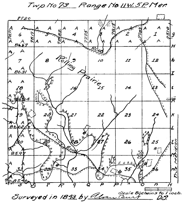
Field notes of the subdivision of Township No. 73 north of Range No. 11, west of the Fifth Principal Meridian, Iowa territory. Surveyed by Alvin Burt, deputy surveyor, November, 1843.
North Between Sect. 35 & 36. Var. 10.46.
11.20 Road N E.
40.00 Set qr. Sect. post & Made Mound of Earth & Sod--Pit 7 lks E.
60.00 Enter thicket.
65.00 Leave thicket.
67.00 Stream 3 S W.
80.00 Set post Cor. of Sect. 25, 26, 35 & 36 & made Mound of Earth & Sod--Pit 8 lks South.
Land rolling 2nd rate--Prairie.
East Random between Sect. 25 & 36.
8.20 Stream 3 S W.
54.50 Road N E.
79.82 Intersect East Boundary 59 lks S of Cor.
Land same.
West Corrected.
39.91 Set qr. sect. post & Made Mound of earth & Sod--Pit 8 lks East.
79.82 Section Cor.
North Between Sect. 25 & 26. 11.06.
40.00 Set qr. sect post & Made Mound of Earth & Sod
Pit 8 lks East.
80.00 Set post cor. of sect. 23, 24, 25 & 26 & Made Mound of earth & Sod--Pit 8 lks South.
Land rolling prairie 2nd rate.
East Random between sect. 24 & 25.
30.15 Drain South.
79.58 Intersect East Boundary.
117 lks. South of Cor.
--Land Same.
West Corrected.
39.79 Set qr. sect. post & made Mound of earth & Sod--pit 7 lks East.
79.58 Section Corner.
North Between sect. 23 & 24. 11.25.
40.00 Set qr. sect. post & Made Mound of Earth & Sod--Pit 7 lks East.
80.00 Set post cor. of sect. 13, 14, 23 & 24 & made Mound of Earth & Sod--Pit 8 lks South.
Land rolling, prairie 2nd rate.
East Random between sect. 13 & 24.
48.00 Road N N W.
80.50 Intersect East Boundary 189 South of Cor.
Land same.
West Corrected.
40.25 Set. qr. sect. post & Made mound of earth & Sod--Pit 7 lks East.
80.50 Section Corner.
North Between sect. 13 & 14. 10.48.
40.00 Set qr. sect. post & Made Mound of Earth & Sod
Pit 7 lks East.
80.00 Set post cor. of sect. 11, 12, 13 & 14
Made Mound of earth & Sod--Pit 7 lks South.
Land rolling 2nd rate. Prairie.
East Random between sect. 12 & 13.
19.50 Road N N W.
38.50 Road N W.
80.32 Intersect E Boundary 2 55 S of Cor.
Land same.
West Corrected.
40.16 Set qr. sect. post & Made Mound of Earth & Sod--Pit 7 lks E.
80.32 Section Cor.
North Between sect. 11 & 12. 10.27.
40.00 Set qr. sect. post & Made Mound of earth & Sod.
Pit 7 lks E.
80.00 Set post cor. of sect. 1, 2, 11 & 12 & Made Mound of earth & Sod--Pit 8 lks South.
Land level 2nd rate. Prairie.
East Random between sect. 1 & 12.
5.70 Road N W.
80.32 Intersect E Boundary 300 South of Cor.
Land rolling, 2nd rate. Prairie.
West Corrected.
40.16 Set qr. Sect. post & Made Mound of earth & Sod
Pit 7 lks E.
80.32 Sec. Cor.
North Between Sect. 1 & 2. 10.15
5.00 Drain N E.
10.00 Road N W.
40.00 Set qr. Sect. post & Made Mound of earth & Sod.
Put 7 lks east.
67.40 Road W.
77.83 Intersect N Boundary at post in Mound.
Land Same.
Nov. 4 1843.
North Between sect. 34 & 35.
21.60 Road W.
23.40 Enter field N E.
33.10 Leave field E & W.
40.00 Set qr. sect. post.
B. Oak 20 S 10 W 53.
B. Oak 12 N 31½ E 45.
50.00 Leave brush & Enter prairie E & W.
80.00 Set post cor. of sect. 26, 27, 34 & 35 & made mound of earth & sod Pit lks South (sic).
Land rolling 2nd rate, first 50 chs W. & B. Oak, Elm & Hazle, Plumb & Prickley-Ash brush.
East Random between sect. 26 & 35.
52.90 Drain S East.
70.00 Enter thicket.
77.50 Leave thicket.
79.96 Intersect at post.
Land rolling prairie 2nd rate.
West Corrected.
39.98 Set qr. sect. post & Made Mound of earth & sod.
Put 7 lks East.
North Between sect. 26 & 27. 11.17.
40.00 Set qr. Sect. post and made mound of Earth & Sod.
Put 7 lks east.
80.00 Set post cor. of sect. 22, 23, 26 & 27 & made Mound of earth & sod--Pit 8 lks South.
Land rolling 2nd rate. Prairie.
East Random between sect. 23 & 26.
79.70 Intersect 9 lks South.
Land same.
West Corrected.
39.95 Set qr. Sect. post & Made Mound of earth & sod--Pit 7 lks East.
79.90 Section Cor.
North Between sect. 22 & 23.
40.00 Set qr. Sect. post & Made Mound of Earth & Sod.
Pit 7 lks East.
40.25 Drain S W.
56.20 Drain S S E.
80.00 Set post cor. of Sect. 14, 15--22 & 23.
Land rolling 2nd rate. Prairie & made mound of earth and sod--Pit 7 lks South.
East Random between Sect. 14 & 23.
44.00 Drain S W.
79.92 Intersect at post.
Land rolling 2nd rate Prairie.
West Corrected.
39.96 Set qr. Sect. post & Made Mound of earth & sod.
Pit 7 lks East.
79.92 Sec. corner.
North Between sect. 14 & 15. 10.12.
40.00 Set qr. Sect. post & made mound of earth & sod.
Put 7 lks South.
Land south half rolling, North half level. 2nd rate--Prairie.
East Random between sect. 11 & 14.
80.00 Intersect 8 lks North.
Land level--prairie 2nd rate.
West Corrected.
40.00 Set qr. sect. post & Made Mound of earth & sod--Pit 7 lks east.
80.00 Sec. Cor.
North Between sect. 10 & 11. 10.00.
40.00 Set qr. Sect. post & made mound of earth & sod.
Pit 7 lks East.
80.00 Set post cor. of sect. 2, 3, 10 & 11, & made mound of earth & sod.
Pit 8 lks South.
Land South half level. North half rolling. 2nd rate.--Prairie.
East Random between Sect. 2 & 11.
73.30 Drain N E.
80.00 Intersect at post.
--Land rolling 2nd rate--prairie.
West Corrected.
40.00 Set qr. Sect. post & Made Mound of earth & sod.
Pit 7 lks East.
80.00 Section Corner.
North Between sect. 2 & 3. 10.00.
29.00 Road West.
40.00 Set qr. Sect. post & Made Mound of earth & sod.
Pit 7 lks East.
78.13 Intersect North Boundary at post in Mound.
Land rolling, 2nd rate. Prairie.
November 5th, 1843.
North Between Sect. 33 & 34.
4.66 W. Oak 20 in dia.
40.00 Set qr. Sect. post.
W. Oak 12 S 43 W 7.
Elm 9 N 11 E 16.
45.50 Road S W.
65.68 B. Oak 10 in dia.
78.75 Road N W.
80.00 Set post, Cor. of Sect. 27, 28, 33 & 34.
B. Oak 10 N 34 W 37.
W. Oak 12 S 68 E 67.
Land rolling, 2nd rate.
Elm, Hickory, W. & B. Oak, Lynn & Hazle brush.
East Random between Sect. 27 & 34.
35.00 Enter prairie N & S.
80.06 Intersect at post.
Land rolling 2nd rate, W½ Same. Rest prairie.
West Corrected.
40.03 Set qr. Sect. post & Made Mound of earth.
Pit 7 lks E.
B. Oak 18 in. dia.
80.06 Section cor.
North Between Sect. 27 & 28. 10.40.
18.60 Stream 8 S W.
40.00 Set qr. Sect. post.
Hickory 15 N 88 E 26.
Hickory 12 W 74 W 30.
55.00 Road W.
65.00 Enter prairie E & W.
78.00 Enter field N N E.
80.00 Set post cor. of sect. 21, 22, 27 & 28 & Made Mound of earth.
Pit 8 lks South.
Land rolling 2nd rate.
Elm, Hickory, W. & B. Oak, lynn, & Hazle brush, Prickley Ash & Crab Apple brush.
East Random between Sect. 22 & 27.
41.15 Drain South.
45.00 Drain S W.
80.04 Intersect 8 lks North.
Land rolling 2nd rate. Prairie.
West Corrected.
40.02 Set qr. Sect. post.
Cherry 10 S 80 W 8.
80.04 Section cor.
0.20 Leave field N N E.
North Between Sect. 21 & 22. 10.00.
7.50 Leave field E & W.
40.00 Set qr. Sect. post & Made Mound of earth & Sod.
Pit 7 lks East.
80.00 Set post Cor. of sect. 15, 16, 21 & 22 & Made Mound of earth & sod.
Pit 7 lks South.
Land Same.
East Random between Sect. 15 & 22.
67.20 Drain S E.
80.02 Intersect at post.
Land Same.
West Corrected.
40.01 Set quarter Sect. post & Made Mound of earth & Sod.
Pit 7 lks East.
80.02 Section Cor.
North Between Sect. 15 & 16. 9.40.
40.00 Set qr. Sect. post & Made Mound of earth & sod.
Pit 7 lks East.
80.00 Set post cor. of Sect. 9, 10--15 & 16 & Made Mound of earth & sod Pit 7 lks South.
Land rolling 2nd rate. Prairie.
East Random between Sect. 10 & 15.
79.92 Intersect at post.
Land level Prairie. 2nd rate.
West Corrected.
39.96 Set qr. Sect. post & Made Mound of earth & sod.
Pit 7 lks East.
79.92 Sect. Cor.
North Between Sect. 9 & 10. 9.25.
40.00 Set qr. Sect. post & Made Mound of earth & sod.
Pit 7 lks East.
73.00 Road West.
80.00 Set post cor. of sect. 3, 4, 9 & 10 & Made Mound of earth & sod--Pit 7 lks South.
Same.
East Random between sect. 3 & 10.
32.00 Stream 3 North.
47.60 Drain North.
61.50 Road S W.
79.86 Intersect at post.
Land rolling 2nd rate. Prairie.
West Corrected.
39.93 Set qr. Sect. post & Made Mound of earth & sod.
Pit 7 lks East.
79.86 Section corner.
North Between Sect. 3 & 4. 9.20.
40.00 Set qr. Sect. post & Made Mound of earth & sod.
Pit 7 lks East.
77.75 Intersect North Boundary at post in Mounds.
Same.
North Between Sect. 32 & 33.
39.90 Road N W.
40.00 Set qr. Sect. post.
B. Oak 10 S 55 W 140.
B. Oak 18 N 45 E 276.
52.80 Spring Brook 3 S E.
72.00 Enter prairie E & W.
80.00 Set post corner of section 28, 29, 32 & 33 & Made Mound of earth & sod. Pit 8 lks South.
Land rolling, 2nd rate.
W & B Oak, & Hazle Brush.
East Random between Sect. 28 & 33.
11.00 Leave prairie N W.
46.30 Stream 10 South.
79.00 Road W N W.
79.78 Intersect 4 lks South.
Land Same.
West Corrected.
2.28 Hickory 12 in. dia.
38.89 Set qr. Sect. post.
W. Oak 14 N 74 W 50.
W. Oak 18 S 55 W 54.
79.78 Section corner.
North Between sect. 28 & 29. 10.00.
27.50 Road West.
35.00 Leave prairie N N W.
40.00 Set qr. Sect. post.
B. Oak 7 N 21½ W 131.
Aspen 6 S 38 E 83.
49.58 B. Oak 18 in. dia.
80.00 Set post corner of sect. 20, 21, 28 & 29.
Hickory 10 S 65 E 182.
B. Oak 10 S 15 E 104.
Land rolling 2nd rate part prairie & W & B Oak, & Hazle, plumb & Crab apple Brush.
East Random between Sect. 21 & 28.
4.50 Drain South.
5.00 Stream 10 South.
25.00 Enter prairie N & S.
70.50 Enter field N & S.
79.82 Intersect at post.
Land rolling 2nd rate. First 25 chains W & B Oak, Elm & Hazle Plumb, Crab-Apple, & Prickley, Ash Brush,
rest prairie.
West Corrected.
39.91 Set qr. sect. post & Made Mound of earth & sod.
Pit 7 lks East.
79.82 Sect. corner.
North Between sect. 20 & 21. 9.40.
2.50 Drain East.
39.20 Stream 8 S E.
40.00 Set qr. Sect. post.
Cottonwood 16 S 61 E 107.
Cottonwood 16 S 83 W 148.
40.00 Enter prairie.
79.20 Drain S W.
80.00 Set post cor. of sect. 16, 17--20 & 21 & Made Mound of earth & sod--Pit 7 lks South.
Land Same.
East Random between Sect. 16 & 21.
11.75 Drain S W.
79.78 Intersect 10 lks South.
Land rolling, 2nd rate. Prairie.
West Corrected.
39.89 Set qr. Sect. post & Made Mound of earth & sod Pit 7 lks East.
79.78 Section corner.
November 7th, 1843.
North Between sect. 16 & 17. 9.25.
40.00 Set qr. Sect. post & Made Mound of earth & sod.
Pit 7 lks East.
80.00 Set post corner of sect. 8, 9, 16 & 17 & Made Mound of earth & sod--Pit 8 lks South.
Land rolling, Prairie 2nd rate.
East Random between Sect. 9 & 16.
67.50 Drain South.
79.78 Intersect 6 lks South.
Land same.
West Corrected.
39.89 Set qr. Sect. post & made Mound of earth & sod--Pit 7 lks East.
79.78 Section Cor.
North Between Sect. 8 & 9. 9.18.
23.20 Drain S W.
40.00 Set qr. Sect. post & Made Mound of earth & sod.
Pit 7 lks East.
Land rolling 2nd rate. Prairie.
East Random between Sect. 4 & 9.
72.20 Road N W.
79.82 Intersect 4 lks South.
Land Level Prairie 2nd rate.
West Corrected.
39.91 Set qr. Sect. post & Made Mound of earth & sod.
Pit 7 lks East.
79.82 Section Corner.
North Between Sect. 4 & 5. 91.5 (sic - 9.15?).
24.00 Road West.
40.00 Set qr. Sect. post & made Mound of earth & sod.
Pit 7 lks East.
77.82 (Sic - 78.82 on map) Intersect North Boundary at post in mound.
Land rolling 2nd rate. Prairie.
North Between Sect. 31 & 32.
35.00 Road E & W.
38.25 Drain S W.
40.00 Set qr. Sect. post.
Hickory 10 S 20 E 16.
Hickory 12 N 20 W 20.
62.73 Elm 18 in dia.
80.00 Set post Cor. of Sect. 29, 30--31 & 32.
Elm 9 S 36 W 20.
B. Oak 16 N 51 W 63.
Land rolling 2nd rate, Hickory, Elm, W. & B. Oak, Elm & Hazle Brush.
East Random between Sect. 29 & 32.
44.50 Enter prairie N & S.
65.50 Road North.
79.78 Intersect at post.
Land west 44 chs. Same, rest rolling, 2nd rate. Prairie.
West Corrected.
39.89 Set qr. Sect. post.
B. Oak 10 N 51 W 12.
B. Oak 14 S 68 E 19.
79.78 Section Corner.
November 8th, 1843.
West Random between Sect. 30 & 31.
31.70 Stream 10 South.
85.97 Intersect West Boundary at post.
Land rolling, 2nd rate.
Hickory, W. & B. Oak, Elm, Lynn & Hazle brush.
East Return.
B. Oak 16 S 52 E 70.
B. Oak 10 N 51 E 40.
6.45 Elm 15 in. dia.
45.97 Set qr. Sect. post.
B. Oak 16 S 10 E 52.
B. Oak 6 North 17.
74.09 Hickory 10 in dia.
85.97 Sect. Corner.
North Between Sect. 29 & 30. 10.00.
12.11 Elm 14 in dia.
17.75 Drain West.
40.00 Set qr. Sect. post.
B. Oak 8 S 85 W 27.
B. Oak 6 N 33 E 45.
45.00 Enter prairie N W.
80.00 Set post corner of Sect. 19, 20--29 & 30 & Made Mound of earth & sod--Pit 7 lks South.
Land rolling 2nd rate, South half W. & B. Oak, Elm, Hickory & Hazle brush--rest Prairie.
East Random between Sect. 20 & 29.
39.50 Enter Brush N & S E.
79.96 Intersect 14 lks South.
Land rolling 2nd rate.
W½ Prairie rest Havle (sic - Hazle), Plumb, Crabapple & Prickley Ash brush.
West Corrected.
39.98 Set qr. Sect. post.
B. Oak 12 S 30 W 56.
B. Oak 14 N 47 E 122.
79.06 Section Corner.
8.00 Road N W.
West Random between Sect. 19 & 30.
20.00 Leave prairie N & S.
30.30 Road S W.
62.50 Stream 10 S E.
86.02 Intersect West Boundary at post.
Land rolling 2nd rate.
W. & B. Oak, Elm, Lynn, Hickory & Hazle Brush.
East Return.
B. Oak 15 S 32 E 44.
B. Oak 16 N 35 E 15.
2.27 B. Oak 9 in dia.
46.02 Set qr. Sect. post.
B. Oak 14 N 76 W 74.
B. Oak 10 N 88¼ E 264.
North Between 19 & 20. 9.35.
10.00 Road N West.
40.00 Set qr. Sect. post & Made Mound of earth & sod.
Pit 7 lks east.
47.00 Enter field E N E.
56.00 Leave field N N W.
80.00 Set post Sect. corners 17, 18, 19 & 20 & Made Mound of earth and sod--Pit lks South (sic).
Land level 2nd rate. Prairie.
East Random between Sect. 17 & 20.
12.00 Enter thicket.
25.00 Leave thicket.
52.80 Stream 4 South.
79.88 Intersect at post.
Land rolling 2nd rate, mostly prairie.
West Corrected.
39.94 Set qr. Sect. post & Made Mound of Earth & Sod.
Pit 7 lks East.
79.88 Section Corner.
Noveber 9th, 1843.
West Random between Sect. 18 & 19.
46.00 Enter thicket.
58.00 Stream 3 South.
64.50 Leave Thicket.
78.00 Enter brush.
86.24 Intersect West Boundary 10 lks N of post.
Land Same.
East Corrected.
Aspen 6 N 84½ E 183.
B. Oak 6 S 83¼ E 235.
46.24 Set qr. Section post & Made Mound of earth & sod. Pit 7 lks East.
86.24 Sec. Corner.
North Between Sec. 17 & 18. 9.25.
40.00 Set qr. sect. post & Made Mound of earth & Sod.
Pit 7 lks East.
79.50 Stream 3 S S E.
80.00 Set post cor. of Sect. 7, 8, 17 & 18 & Made Mound of earth & sod--Pit 7 lks South.
Land rolling, 2nd rate. Prairie.
East Random between Sect. 8 & 17.
41.50 Stream 3 S W.
79.92 Intersect 6 lks South.
Land Same.
West Corrected.
39.96 Set qr. Sect. post & Made Mound of earth & sod.
Pit 7 lks East.
79.92 Section Corner.
West Random between 7 & 18.
0.10 Stream 3 South.
86.31 Intersect West Boundary 12 lks North of post in mound.
East Corrected.
46.31 Set qr. Sect. psot & Made Mound of earth & sod.
Pit 7 lks East.
86.31 Sect. Corner.
North Between Sect. 7 & 8. 9.15.
40.00 Set qr. Sect. post & Made Mound of earth & sod.
Pit 7 lks East.
43.20 Drain S W.
80.00 Set post corner of Sect. 5, 6--7 & 8 & Made Mound of earth & sod--Pit 7 lks South.
Land rolling 2nd rate. Prairie.
East Random between Sect. 5 & 8.
79.92 Intersect at post.
Land level 2nd rate. Prairie.
West Return.
39.96 Set qr. Sect. post & made mound of earth & sod.
Pit 7 lks East.
79.92 Section Corner.
West Random between Sect. 6 & 7.
86.59 Intersect West Boundary 9 lks N of post.
Land level 2nd rate. Prairie.
East Corrected.
46.59 Set qr. Sect. post & made mound of earth & sod.
Pit 7 lks East.
86.59 Sect. Cor.
North Between Sect. 5 & 6. 9.07.
40.00 Set qr. Sect. post & Made Mound of earth & sod.
Pit 7 lks East.
61.40 Road West.
78.19 Intersect North Boundary at post in Mound.
Land level 2nd rate. Prairie.
November 10th, 1843.
The face of this township is rolling, soil dark loam; it is mostly prairie; the timber is in the S W part & is mostly W. & B. Oak, Elm & Hickory Undergrowth, mostly Hazle. The streams are nearly dried up.
I, Alvin Burt, Deputy Surveyor, do hereby certify and solemnly swear that in pursuance of a contract with James Wilson, Surveyor General of the United States for the territories of Wisconsin and Iowa, bearing date the 30th day of September, A. D. 1843, and in strict conformity to the laws of the United States and the instructions of said Surveyor General, I have surveyed and subdivided into Sections, Township No. 73 North, in Range No. 11 West of the 5th principal Meridian, in the Territory of Iowa. And I do further certify and swear that the foregoing are the true and Original Field Notes of the Said Survey and Subdivision executed as aforesaid.
Certified this 26th day of November, A. D. 1843.
Alvin Burt,
Dep. Survey.
Thomas Hurley,
Jeremiah Farrell,
Chainmen.
William Higgins,
Benjamin Higgins,
Markers.
Territory of Iowa.
Surveyor Generals Office May 29th, 1844. Then the said Alvin Burt, Dep. Surv., personally appeared and made solemn Oath that the above Oath and certificate by him subscribed is true before me.
James Wilson,
Surveyor General.
Return to the 1912 History of Jefferson County Contents Page