 |
Locust Grove Township |
 |
|
|
Locust Grove Township |
|
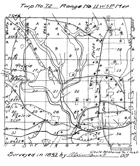
Field notes of the subdivision of Township No. 72, North of Range No. 11, west of the Fifth Principal Meridian, Iowa Territory. Surveyed by Alvin Burt October, 1843.
North Between sect. 35 & 36
12.43 Hickory 12 in diameter.
30.00 Enter Bottom E & W.
40.00 Set quarter Sect. post.
B. Oak 12 S 59 W 39.
Birch 10 N 79 E 15.
54.00 Cedar Cr. 75 E.
56.36 Maple 20 in Diam.
60.00 Leave bottom E & W.
69.00 Drain S E.
80.00 Set post corner of sect. 25, 26, 35 & 36.
B. Oak 20 S 88 T 4 E 75.
W. Oak 22 N 43 W 55.
Land roling (sic) 2nd rate.
W & B oak, Hickory, Elm, Maple, Birch, Hazle, Oak & Crabapple Brush.
East Random between sect. 25 & 36.
21.00 Drain S E.
23.50 Drain South.
53.00 Enter bottom N E.
65.20 Pond S W.
79.87 Intersect 8 Lines south.
------ Land same.
West Corrected.
3.50 W. Oak 28.
39.93½ Set quarter Sect. post.
Hickory 14 S 20 E 9.
Hickory 12 N 9 W 70.
79.87 Section Corner.
North Between Sect. 23 & 26 (sic - 25 & 26) Var 10° 52'. E.
9.10 W. Oak 24 in dia.
27.50 Enter fields E & W.
37.50 Road E & W.
40.00 Set quarter, Sect. post.
W. Oak 15 W 88¼ E 261.
53.80 W. Oak 20 in dia.
80.00 Road E & W.
80.00 Set post corner of Sect. 23, 24, 25 & 26.
W. Oak 24 S 88 E 1368.
East Random between sect. 24 & 25.
15.00 Leave field N & S.
26.40 Drain South.
63.50 Road N & S.
63.85 Enter field N & S.
80.46 Intersect 42 links so.
Same.
West Corrected.
40.00 Set quarter section post.
Hickory 12 W 58 E 108.
W Oak 12 S 10 W 74.
80.46 Section Corner.
North Between Sect. 23 & 24 Var 10° 30'.
34.00 House 50 lks. W.
36.00 Leave fields E & W.
40.00 Set quarter, Sect. post.
Elm 9 S 70 E 16.
B. Oak 30 S 52 E 43.
46.00 Enter prairie E & W.
69.00 Enter field S E N W.
80.00 Set post Cor. of Sect. 13, 14, 23 & 24 and made Mound of Earth Pit 8 lks South.
Land Same.
Oct. 16th, 1843.
East Random between Sect. 13 & 24.
18.90 Leave field N W.
19.20 Road N W.
50.00 Stream 10 S E.
60.80 Road N & S.
66.30 Enter field N & S.
74.75 Leave field N & S.
80.34 Entersect (sic) E Boundary, 56 lks S of post.
Land roling second rate.
W & B Oak, Hickory, & etc.
West Corrected.
40.17 Set quarter Sect. post.
W. Oak 16 S 54 W 47.
W. Oak 18 N 6 E 81.
80.34 Sec. Cor.
North Between Sect. 13 & 14 Var 10° 24'.
24.00 Leave field E & W.
24.27 Hickory 12.
24.50 Read (sic - Road?) E & W.
32.25 Stream 10 S E.
40.00 Set quarter Sect. post.
B. Oak 12 N 26 E 42.
B. Oak 10 S 52 W 33.
44.50 Enter field E & W.
54.50 Road E & W.
70.75 Road E & W.
80.00 Set Post cor. of Sect. 13, 14, 23 & 24 (sic - 11, 12, 13 & 14) & Made Mound of Earth Pit 7 lks south.
Same.
East Random between sect. 12 & 13.
36.00 Leave fields N & S.
72.50 Stream 10 S.
80.42 Intersect E Boundary 122 lks. South of post land roling 2nd rate.
W & B oak, Hickory & Hazle Brush.
West Corrected.
7.38 B. Oak 18.
40.21 Set quarter post W. Oak 16 N 81½ E 94.
80.42 Section Cor.
North Between Sect. 11 & 12 Var 10° 08'.
40.00 Set quarter sect.
Made Mound of earth Pit 6 lks East.
42.80 Leave field in prairie E & W.
67.30 Enter field E & W.
80.00 Set post cor. of Sect. 1, 2, 11 & 12 and made Mound of Earth & Sod.
Land gently rolling, 2nd rate -- Fields.
East Random between sect. 1 & 12.
44.50 Leave fields N & S.
66.75 Stream 5 S E.
79.96 Intersect E Boundary 198 lks South of Post Land.
W½ Same. E½ roling W & B Oak, Elm, Hickory & Hazle.
West Corrected.
39.98 Set quarter Sec. post.
B. Oak 12 N 66½ E 419.
79.96 Sec. Cor.
North Between sect. 1 & 12 Var. 10° 06'.
40.00 Set quarter sec. post & Made Mount (sic) of earth Pit 7 lks East.
49.70 Road N W.
83.00 Leave fields E & W.
85.91 Intersect N Boundary at post in Mound.
Land gently roling, 2nd rate, fields -- prairie.
October 17th, 1843.
North Between Sect. 34 & 35 Var 11° 8'.
4.44 B. Oak 16.
7.00 Enter wet prairie bottom E & W.
39.75 Leave wet prairie W E.
40.00 Set quarter sect. post.
B. Oak 30 S 77 W 70.
B. Oak 20 N 81 E 244.
42.75 Cedar Br. 75 E.
Hick. 15 in diam.
78.25 Leave bottom E & W.
79.00 Enter field E & W.
80.00 Set post cor. of sect's 26, 27, 34 & 35.
W. Oak 15 N 72 E 53.
W. Oak 15 N 51 W 49.
Land (except bottom) rolling, 2nd rate--bottom level & wet, W & B. Oak, Hickory, Elm, Maple, etc.
East Random between sect. 26 & 35.
40.50 Leave field N & S.
41.25 Drain South.
53.25 Road N & S.
60.25 Drain S E.
80.00 Intersect 36 lks. N.
Land rolling, 2nd rate W & B. Oak, Hickory, Elm & Hazle brush.
West Corrected.
Hickory 10.
40.00 Set qr. Sect post.
W. Oak 10 S 69 E 89.
B. Oak 18 N 83 E 181.
80.00 Sect. Cor.
North Between Sect. 26 & 27 10° 48'.
14.75 Road E & W.
40.00 Set qr. sect. post & Made Mound of earth.
57.70 Leave field E & W.
58.00 Road E & W.
63.48 W. Oak 12 in diam.
76.50 Enter field S W.
80.00 Set post cor. sect. 22, 23, 26 & 27.
B. Oak 15 N 62½ E 549.
Same.
East Random between sect. 23 & 26.
1.50 Leave field N & S.
34.00 Enter field N & S.
51.50 Road N & S.
79.92 Intersect at post.
Same.
West Corrected.
39.96 Set qr. sect. post.
Cherry 12 W 664.
Cherry 14 N 89½ W 664.
79.92 Sect. cor.
North Between Sect. 23 & 22 10° 30'.
10.00 Leave field E & W.
25.80 Elm 10 in dia.
40.00 Set qr. sect. post.
W. Oak 10 N 34 E 68.
W. Oak 10 S 42 W 27.
65.35 Hickory 15 in dia.
80.00 Set post cor. of sect. 14, 15, 22 & 23.
W. Oak 15 N 32 W 27.
W. Oak 14 S 41 E 92.
Land rolling, 2nd rate.
W & B. Oak, Elm, Hickory, Hazle Oak, Hickory & Plumb brush (sic).
East Random between sect. 14 & 23.
7.00 Enter prairie N & S.
25.00 Enter field N & S.
34.50 Read N & S (sic - Road?).
79.86 Intersect 6 lks S. Land gently rolling, mostly prairie, 2nd rate.
West Corrected.
39.93 Set qr. sect post & made mound of Earth in field.
79.06 B. Oak 20 in dia.
79.86 Sect. Cor.
Oct. 18th, 1843.
North Between sect. 14 & 15 10° 08'.
11.94 B. Oak 16 in dia.
14.50 Road west.
30.00 Drain West.
40.00 Set qr. sect. post.
W. Oak 18 S 8½ W 35.
W. Oak 16 S 85 E 87.
63.68 Hickory 14 in dia.
63.78 Road S W.
80.00 Set post, cor. of sect. 10, 11, 14 & 15.
W Oak 12 S 12½ E 26.
W Oak 12 N 23 W 45.
Land rolling 2nd rate.
W & B Oak, Hickory, Elm & Hazle brush.
East Random between sect. 11 & 14.
29.50 Enter field N & S.
43.00 Road N & S.
80.00 Intersect 10 lks. so. Land Same.
West Corrected.
40.00 Set qr. sect. post.
Elm 18 S 87½ W 91.
B. Oak 20 N 74½ E 72.
80.00 Sect. Cor.
North Between sect. 10 & 11 10° 08'.
11.50 Road west.
16.32 S. Oak 12 in dia.
40.00 Set qr. sect. post.
W. Oak 24 S 35 W 9.
W. Oak 20 N 87 E 45.
80.00 Set post cor of sect. 2, 3, 10 & 11.
B. Oak 10 N 57 W 12.
W. Oak 20 S 59 E 52.
W & B Oak, Elm, Hickory, & Hazle brush.
East Random between 2 & 11.
20.50 Road W N W.
53.00 Enter field N W.
60.00 Leave field N W.
65.00 Road S W.
65.50 Enter field N W.
79.90 Intersect 48 lks. South, Land Same.
West Corrected.
37.56 Elm 20 in dia.
39.95 Set qr. sect. post.
W. Oak 18 N 59 E 85.
B. Oak 8 S 47 W 21.
79.90 Sect. Cor.
North Between sect. 2 & 3 10° 35'.
14.50 Road N W.
15.45 W. Oak 15.
19.00 Stream 15 S W & enter bottom.
27.00 Leave bottom S W.
39.75 Enter field S E.
40.00 Set qr. sect. post.
B. Oak 36 S 71 W 54.
Hickory 10 S 6 E 41.
53.50 Leave field S W.
65.46 Elm 14.
86.64 Entersect North Boundary 27 lks. E of post & set post cor. of sect. 2 & 3.
B. Oak 12 S 11 W 92.
W. Oak 12 S 35 E 144.
Land Same.
Oct. 19th, 1843.
North Between Sects. 33 & 34 10° 51'.
18.70 W. Oak 18 in dia.
24.25 Road E & W.
27.50 Enter bottom E & W.
29.75 Stream 50 E.
40.00 Set qr. sect. post.
W. Oak 14 S 72 E 62.
B. Oak 8 N 87½ W 57.
55.00 Leave bottom N E.
68.70 Road E & W.
76.85 B. Oak 14 in dia.
80.00 Set post cor. of sect. 27, 28, 33 & 34.
W. Oak 12 S 6 E 116.
W. Oak 12 S 61 W 127.
Land rolling, 2nd rate.
W & B Oak, Elm, Hickory & Hazle brush.
East Random between sect. 27 & 34.
10.00 Enter bottom N & S.
21.50 Cedar Cr. 75 S E.
39.50 Drain S E.
42.00 Leave bottom S E.
43.00 Enter fields N & S.
57.00 Road S W.
80.08 Intersect 42 lks. S. Land (except bottom) rolling 2nd rate W & B Oak, etc.
West Corrected.
40.04 Set qr. sect. post.
W. Oak 36 N 50 E 5.
W. Oak 12 S 35 W 26.
69.50 B. Oak 20 in dia.
North Between sect. 27 & 28 10° 33'.
40.00 Set qr. sect. post.
W. Oak 24 S 57 W 32.
W. Oak 22 N 73 E 97.
42.00 Enter bottom S E.
45.00 Cedar Cr. 75 East.
49.90 B. Oak 15 in dia.
55.00 Leave bottom S E.
80.00 Set post Cor. of sect. 21, 22 27 & 28.
W. Oak 12 S 65 W 35.
W. Oak 15 N 5 E 73.
Land rolling 2nd rate.
W & B Oak, Hickory & Hazle brush.
East Random between sect. 22 & 27.
30.50 Enter field N & S.
39.50 Leave field N & S.
41.00 Road N & S.
60.80 Enter field N & S.
79.96 Intersect 6 lks. south.
Land Same.
West Corrected
39.98 Set qr. Sect. post.
Elm 8 S 26 E 33.
Hickory 10 N 13 W 40.
79.96 Sect. Cor.
North Between sect. 21 & 22 10° 15'.
14.51 W. Oak 18 in dia.
25.00 W. Oak 10 in dia.
30.75 Drain West.
40.00 Set qr. sect. post.
W. Oak 12 S 42 W 56.
W. Oak 10 N 36 E 47.
54.60 W. Oak 24 in. dia.
58.25 Stream 20 S W & enter bottom.
70.00 Leave bottom S E.
78.50 Road S W.
80.00 Set post Cor. of sect. 15, 16, 21 & 22.
W. Oak 30 N 21 E 38.
W. Oak 14 S 16 W 33.
Land Same.
East Random Sect. 15 & 22.
1.00 Road S W.
12.00 Enter bottom S W.
40.00 Stream 20 S W & Leave bottom.
79.86 Entersect 18 lks S. Same.
West Corrected.
W. Oak 12 in. dia.
40.00 Set qr. sect. post.
Elm 15 N 33 E 18.
W. Oak 16 N 41 W 23.
69.82 W. O. 15 in dia.
79.86 Sect. Cor.
North Between sect. 15 & 16 10.00.
40.00 Set qr. post sect.
B. Oak 18 N 6 E 75.
B. Oak 24 S 13½ W 97.
58.14 B. Oak 14 in dia.
80.00 Set post Cor. of sect. 9, 10 15 & 16.
W. Oak 24 S 72 W 59.
W. Oak 14 N 68 E 101.
Land rolling 2nd rate.
W & B Oak, Elm, Hickory, Lynn & Hazle Briers, etc.
East Random between sect. 10 & 15.
38.00 Enter bottom south.
49.50 Stream 20 South.
50.00 Leave bottom South.
77.00 Drain South.
80.02 Intersect 10 lks.
Same Land.
West Corrected.
0.40 W. Oak 10.
40.00 Set qr. sect. post.
B. Oak 12 S 13 E 24.
W. Oak 18 N 36 W 37.
68.60 Hickory 15.
80.02 Sect. Corner.
October 20th, 1843.
North Between sect. 9 & 10 10° 30'.
21.37 Elm 14.
40.00 Sect. qr. sect. post.
Elm 12 S 60 W 17.
Elm 10 N 78 E 22.
51.96 Elm 14.
80.00 Set post cor. of sect. 3, 4--9 & 10.
W. Oak 20 S 88 E 40.
W. Oak 22 N 51 W 35.
Same.
East Random between sect. 3 & 10.
2.00 Enter bottom S S E.
19.00 Stream 20 S S E.
21.00 Leave bottom S E & N W.
80.00 Entersect at post.
Land Same.
West Corrected.
11.85 B. Oak 20.
40.00 Set qr. sect. post.
W. Oak 10 S 6 W 36.
W. Oak 10 N 10 W 67.
50.11 W. Oak 15.
80.00 Sect. Cor.
North Between sect. 3 & 4 11.00.
10.00 Enter bottom S E.
22.00 Stream 10 E.
25.00 Leave bottom E W.
40.00 Set qr. sect. post.
W. Oak S 72 E 13.
W. Oak N 56 W 25.
48.15 B. Oak 14.
65.60 Road West.
87.03 Intersect North Boundary 36 lks. East of post and set post. cor of sect. 3 & 4.
W. Oak 16 S 23 E 36.
Hickory 8 S 67 W 22.
Same.
North Between sect. 32 & 33 10.20.
5.00 Leave prairie E & W & Enter brush.
40.00 Set qr. sect post.
W. Oak 14 S 7 E 33.
Elm 15 N 83 E 18.
43.50 Stream 10 East.
80.00 Set post cor. of sects. 28, 29, 32 & 33.
Made Mound of Earth & Sod--Pit 7 lks South.
Land rolling, 2nd rate, Hazle thorn, Plumb & Briers.
East Random between sect. 27 & 33 (sic - 28 & 33) 10.20.
9.00 Road E S E.
41.50 Enter field N & S.
54.70 Leave field N & S.
80.00 Entersect 29 lks. North. Same.
West Corrected.
40.00 Set qr. Sect. post.
B. Oak 15 S 88 W 308.
B. Oak 14 N 62 W 260.
80.00 Sect. Corner.
North Between sect. 28 & 29 10.24.
2.00 Leave brush E & W.
3.50 Road West.
40.00 Set qr. sect. post & Made Mound Pit 7 lks East.
48.50 Leave prairie E & W & Enter brush.
80.00 Set post cor. of sect. 20, 21, 28 & 29 and made Mound Pit 7 lks South.
Land South ½ Prairie, 2nd rate, rest Oak, Hazle & Plumb brush.
Oct. 21, 1843.
East Random between sect. 21 & 28.
17.50 Enter bottom E S E.
21.50 Cedar Cr. 75 E S E.
51.50 Cedar Cr. 75 N E.
61.00 Cedar Cr. 75 S E.
72.00 Leave bottom S E.
80.02 Intersect at post.
Land (except bottom) same on bottom, Elm, W & B Oak, Maple, Ash & Hickory, etc.
West Corrected.
6.17 B. Oak 16.
40.01 Set qr. sect. post.
W. Oak 24 S 76 W 10.
W. Oak 22 N 15 W 34.
80.02 Sect. Corner.
North Between Sect. 20 & 21 10.20.
16.97 W. Oak 20.
37.00 Enter bottom S E.
40.00 Set qr. sect post.
W. Oak 14 S 38 W 71.
B. Oak 14 N 50 E 60.
51.00 Leave bottom S E.
80.00 Set post, cor. of sect. 16 17 20 & 21.
Black Oak 10 N 62 W 15.
Black Oak 10 S 33 E 9.
Land (except bottom) rolling 2nd rate.
W & B Oak & Hazle brush.
42.50 Cedar Cr. 75 East.
East Random between sect. 16 & 21.
35.00 Road W N E.
48.00 Drain South.
53.30 Road N W.
60.00 Enter bottom South.
68.50 Leave bottom South.
60.25 Stream 20 South.
80.14 Intersect 5 lks North.
Same.
West Corrected.
W. Oak 14 in dia.
40.07 Set qr. sect. post.
W. Oak 20 S 42 W 15.
W. Oak 24 N 133.
80.14 Sect. Corner.
North Between sect. 16 & 17 10.33.
19.89 B. Oak 15 in dia.
40.00 Set qr. Section post.
W. Oak 12 S 10 W 149.
W. Oak 16 N 85 W 342.
41.75 Road N W.
62.38 W. Oak 14.
66.00 Drain East.
80.00 Set post cor. of sect. 8, 9, 17 & 16.
W. Oak 24 S 81 W 60.
W. Oak 18 N 80 E 81.
Land rolling 2nd rate W & B Oak etc.
East Random between sect. 9 & 16.
13.00 Enter bottom south.
14.50 Stream 10 S E.
37.00 Leave bottom N W & S W.
55.25 Drain South.
78.60 Drain South.
80.20 Intersect 12 lks. North.
Same.
West Corrected.
4.36 Elm 15 in. dia.
40.10 Set qr. sect. post.
W. Oak 36 N 77 E 19.
Hickory 14 S 65 W 18.
43.64 Section corner.
North Between sect. 8 & 9. 10.45.
19.56 W. Oak 24 in dia.
30.00 Enter bottom S E.
36.75 Stream 10 S E.
40.00 Set qr. Sect. post.
B. Oak 20 S 72 W 17.
Lynn 10 N 61 E 32.
42.00 Leave bottom S E.
62.67 W. Oak 14.
80.00 Set post Cor. of sect. 4, 5--8 & 9.
W. Oak 18 S 67 E 61.
W. Oak 18 N 76 W 40.
Land rolling, 2nd rate.
W & B Oak, Elm, Hickory, etc.
East Random between sect. 4 & 9.
80.18 Intersect post.
Same.
West Corrected.
3.03 W. Oak 18 in diam.
40.09 Set qr. sect post.
Elm 10 S 20 W 37.
Elm 12 N 41 E 36.
80.18 Section Cor.
North Between sect. 4 & 5 11.00.
4.50 Drain S W.
28.28 Elm 20.
40.00 Set qr. sect post.
Hickory 12 S 47 W 5.
B. Oak 10 S 69 E 36.
66.83 W. Oak 16.
84.80 Road West.
86.66 Intersect North Boundary.
9 lks. East post & Set post cor. of sect. 4 & 5.
W. Oak 12 S 76 W 131.
B. Oak 12 S 54 E 255.
Oct. 22nd, 1843.
North Between sects. 31 & 32.
26.25 Spring brook 3 E.
40.00 Set qr. sect. post.
& made mound of Earth & Sod--Pit 7 lks E.
50.75 Road West.
80.00 Set post, cor. of sect.
29, 30--31 & 32 & Made Mound of Earth & Sod Pit 8 lks South.
Land rolling prairie 2nd rate.
East Random between sect. 29 & 32.
13.50 Drain S.
70.00 Road E N E.
80.06 Entersect 18 lks North.
Land Same.
West Corrected.
40.03 Set qr. sect. post & Made Mound of Earth & Sod--Pit 7 lks East.
80.06 Section Cor.
West Random between sect. 30 & 31.
85.37 Intersect at post.
Land level 2nd rate. Prairie.
East Corrected.
45.35 Set qr. sect. post & Made Mound of Earth & Sod Pit 7 lks E.
85.37 Section Cor.
North Between sect 29 & 30 10.30.
40.00 Set. qr. Sect. post & Made Mound of Earth & Sod--Pit 8 lks E.
57.00 Road N W.
73.00 Level prairie E & W Enter brush.
80.00 Set post cor. of sect 19, 20, 29 & 30.
B. Oak 6 S 63 E 125.
B. Oak 6 N 27 E 83.
Land rolling 2nd rate, prairie.
East Random between sect. 20 & 29.
80.00 Intersect 8 lks South.
Land rolling 2nd rate.
Hazle, Oak, thorn Plumb & Hickory brush.
West Corrected.
40.00 Set qr. sect. post.
Hickory 12 N 24 W 68.
Hickory 12 S 86¼ W 76.
80.00 Sect. Corner.
West Random between sect. 19 & 30.
15.15 Road N.
65.75 Drain North.
74.75 Enter field N N W.
79.00 Leave field N S W.
85.91 Intersect south of post.
Land Same.
East Corrected.
Hickory 10 S 15 E 37.
B. Oak 18 N 55 E 186.
45.91 Set qr. sect post.
W. Oak 15 N 89¼ E 56.
W. Oak 14 N 86½ E 263.
85.91 Sect. Corner.
North Between sect. 19 & 20 10.40.
38.00 Enter bottom East.
40.00 Set qr. sect. post.
B. Oak 22 S 40 E 44.
Elm 15 N 30 W 18.
52.00 Cedar Cr. 50 East.
70.44 W. Oak 14 in dia.
74.00 Road N E.
80.00 Set post cor. of sect. 17, 18 19 & 20.
B. Oak 14 N 11 E 60.
W. Oak 6 S 9 E 17.
East Random between sect. (sic - between 17 & 20)
2.50 Enter prairie N W.
3.00 Road North.
33.00 Leave wet bottom S W & N W.
37.50 Leave prairie.
80.00 Intersect 15 lks South.
Land (except bottom) rolling 2nd rate, W & B Oak, Hickory, etc.
West Corrected.
W. Oak W 10.
40.00 Set qr. sect. post.
B. Oak 9 S 57 W 161.
B. Oak 10 S 70 W 177.
80.00 Sect. cor.
Oct. 23rd. 1843.
West Random between sec. 18 & 19.
5.00 Cedar Cr. S W.
15.50 Leave bottom South.
21.00 Enter bottom N.
30.00 Cedar Cr. 50 N E.
41.50 Cedar Cr. 50 S E.
49.50 Cedar Cr. 50 N E.
71.50 Cedar Cr. 50 S E & leave bottom S E.
85.95 Intersect W boundary 10 lks S. of post.
Land mostly bottom 2nd rate.
W & B Oak, Elm, Maple, Hickory, Ash, etc.
East Corrected.
Hickory 12 N 21 E 40.
B. Oak 14 S 49 E 40.
4.04 B. Oak 15.
45.95 Set qr. sect. post.
W. Ash N 45 W 27.
Hickory 21 S 15 W 25.
78.39 Hackberry 36.
85.95 Sect. Cor.
North Between sect. 17 & 18 10.38.
10.00 Enter prairie N W.
34.00 Leave bottom W & S E.
38.50 Enter grove.
40.00 Set qr. sect. post.
B. Oak 10 S 22 W 24.
B. Oak 10 N 38 E 24.
45.00 Leave grove.
47.00 Road N N W.
80.00 Set post cor. of sect. 7, 8, 17 & 18 and Made Mound--Pit 10 lks S.
Land rolling (except bottom) 2nd rate--mostly prairie.
East Random between sect. 8 & 17.
46.25 Road N W.
55.00 Leave prairie N W.
79.70 Intersect 7 lks south of Cor.
Land rolling 2nd rate.
W & B Oak, & Hickory.
West 55 chs prairie.
West Corrected.
11.28 W. Oak 16.
39.85 Set qr. sect. post & made Mound of Earth & Sod--Pit 8 lks E.
79.70 Sect. Cor.
West Random between sect. 7 & 18.
65.10 Drain South.
85.83 Intersect W Boundary.
18 lks. S of post in Mound--Land rolling prairie, 2nd rate.
East Corrected.
Elm 14 N 86½ E 188.
45.83 Set qr. sect post and made Mound of Earth & Sod Pit 7 lks East.
85.83 Sect. Cor.
North Between sect. 7 & 8 10.55.
40.00 Set. qr. sect. post & Made Mound of Earth & Sod--Pit 7 lks East.
45.00 Road N N E.
78.00 Road N W.
80.00 Set post cor. of sect. 5, 6, 7 & 8.
W. Oak 15 N 70 E 280.
W. Oak 22 S 51 E 293.
Land rolling 2nd rate, prairie.
East Random between sect 5 & 8.
3.00 Leave prairie N W.
30.00 Enter bottom S E.
34.75 Stream 10 S E.
47.00 Leave bottom S E.
80.00 Intersect at post.
Land rolling 2nd rate.
W & B Oak, Hickory, Elm, etc.
West Corrected.
11.06 W. Oak 12 in dia.
40.00 Set. qr. sect. post.
Elm 12 N 18 W 29.
Hickory 12 S 2 E 36.
54.81 W. Oak 12 in dia.
76.99 W. Oak 15 in dia.
80.00 Sect. Cor.
West Random between sect. 6 & 7.
0.50 Road N W.
47.00 Road South.
85.65 Intersect West Boundary at post in Mound. Same.
East (Corrected.)
45.65 Set qr. sect. post & Made Mound of Earth & Sod Pit 7 lks E.
85.65 Sect. Corner.
North Between sect. 5 & 6.
10.00 Leave prairie S E.
13.66 W. Oak 16 in. dia.
40.00 Set qr. sect. post.
W. Oak 11 N 42 E 7.
B Oak 20 S 12 W 21.
44.00 Enter bottom S E.
45.50 Stream 10 S E.
60.00 Leave bottom S E.
66.68 Hickory 18 in dia.
77.50 Drain S W.
86.59 Intersect N Boundary 23 lks E of post & Set post cor. of sect. 5 & 6.
Elm 12 S 77 E 47.
Hickory 8 S 52 W 17.
Land rolling 2nd rate.
W & B Oak, Elm, Hickory etc.
Oct. 24th, 1843.
The face of this township is rolling. Soil a dark loam. The bottom lands are level and some wet soil clayey.
The timber is principally White & Black Oak, & Hickory Undergrowth (Hazle mostly) The streams are dried up except puddles of stagnated water in their beds.
See diagram.
I, Alvin Burt, Deputy Surveyor do hereby certify and solemnly swear that in pursuance of a contract with James Wilson, Surveyor General of the United States for the Territories of Wisconsin & Iowa bearing date, the 30th day of September, A. D. 1843, and in strict conformity to the laws of the United States and the instructions of said Survey General, I have surveyed and subdivided into Sections, Township No. 72, North in Range No. 11, West of the 5th Principal in the Territory of Iowa. And I do further certify and swear that the foregoings are the trune (sic) and original Field Notes of the said Survey and subdivision executed as aforesaid.
Certified this 28th day of October, A. D. 1843.
Alvin Burt,
Dep. Sur.
Thomas Hurley,
Jeremiah Farrill,
Chainmen.
William Wiggins,
Benjamin Wiggins,
Markers.
Territory of Iowa.
Surveyor Generals Office May 29th, 1844. Then the said Alvin Burt Deputy Sur. personally appeared and made solemn Oath that the above Oath and certificate by him subscribed is true, Before me.
James Wilson,
Sur. Gen'l.
Return to the 1912 History of Jefferson County Contents Page