 |
Center/Fairfield Township |
 |
|
|
Center/Fairfield Township |
|
Field Notes of Township No. 72, North of Range 10, West of the Fifth Principal Meridian, Iowa Territory. Surveyed by Hugill & Freeman. Commenced July 9, 1841. Completed July 29, 1841.
North Between sec. 35 & 36
13.25 Run 2 links W.
26.88 Enter field.
40.00 Set qr. sec. post in mound, Pit 4 L links E.
59.84 Leave field.
72.25 Road to Fairfield N N E.
73.10 Enter field.
80.00 Set post in mound Cor. sec. 25, 26 35 & 36 Pit 4 Links S.
Level, dry prairie, 2nd rate.
Var 9.20 E.
East Random between Sec. 25 & 36.
1.45 Leave field.
1.50 Road to Fairfield N N E.
17.20 Road N.
65.00 Leave prairie.
80.00 Intersect range line 35 S of post. Land 2nd rate, rolling, 15 chains on E half W B. Oak Hick, S. Oak.
West Corrected between sec. 25 36.
40.00 Set qr. sec. post in mound Pit 4 Links E.
On S W qr. os (sic) sec. 25 is situated the town of Fairfield.
80.00 Sec. cor.
Var 9.35.
North Between Sec's 25 & 26.
19.15 House 1 link W of line.
20.25 Leave field.
21.30 Road to Fairfield N E.
29.70 Enter field.
40.00 Set qr. post in mound Pit 4 Links E.
40.05 Leave field.
40.75 Road W.
47.00 Road from Fairfield N W.
80.00 Set post cor. sec. 23, 24, 25 & 26.
Hick 14 S 60½ W 64½.
Hick 12 S 49 E 56.
Land rolling, 2nd rate prairie, except few chains on north, Hick. Hazel, etc.
Var 9.20.
East Random between sec. 24 & 25.
23.30 Run 4 Links E S E & Leave grove.
63.65 Run 3 links S.
79.81 Intersect range line 120 links S of post.
Land rolling, 2nd rate, prairie.
Few chains on W. W. Oak, Hick. Hazel.
West Corrected between sec. 24 & 25.
39.90½ Set qr. sec. post in mound Pit 4 Links E.
79.81 Sec. cor.
July 9th, 1841.
Var 10.7 E.
North Between sec. 23 & 24.
15.60 Run 2 links S E.
18.00 Enter prairie.
40.00 Set qr. sec. post in mound Pit 4 Links E.
74.25 Ravine S S W.
80.00 Set post in mound Pit 4 links S.
Cor sec. 13, 14, 23 & 24.
Land rolling, 2nd rate, prairie except a few chains on S half Hick, hazel, W. Oak.
Var 9.35 E.
East Random between sec. 13 & 24.
4.00 Leave ravine.
79.21 Intersect range line 145 S of post.
West half rolling, East half mostly level, all 2nd rate.
West Corrected between sec. 13 & 24.
39.60½ Set qr. sec. post in mound Pit 4 Links E.
79.21 Sec. cor.
Var 10.38 E.
North Between sec. 13 & 14.
40.00 Set qr. sec. post in mound Pit 4 Links E.
80.00 Set post in mound.
Cor. sec's 11, 12, 13 & 14.
Part level, part rolling, 2nd rate.
Var 10.10.
East Random between sec's 12, 13.
79.61 Intersect range line 145 S of post.
West half, gently rolling, E. half, level, rather wet.
2nd rate.
West Corrected between sec. 12 13.
39.80½ Set qr. sec. post in mound, Pit 4 Links E.
79.61 Sec. cor.
Var 11.10 E.
North Between sec's 11 & 12.
13.50 Road from Fairfield N N E.
40.00 Set qr. sec. post in mound Pit 4 links E.
80.00 Set post cor. sec's 1, 2, 11 & 12 in mound Pit 4 links S. Land gently rolling, 2nd rate.
Var 10.30 E.
East Random between sec. 1 & 12.
5.15 Road from Fairfield N N E.
50.00 Brush creek 5 chains N of line E.
80.40 Intersect range line 150 S of post.
Land rolling 2nd rate prairie.
West Corrected between sec. 1 & 12.
40.20 Set qr. sec. post in mound. Pit 4 links E.
80.40 Sec. cor.
Var 11.35 E.
North Between sec. 1 & 2.
25.00 Ravine.
30.00 Leave ravine E.
40.00 Set qr. sec. post in mound Pit 4 Links E.
53.00 Enter prairie. E S E.
59.00 Leave ravine.
79.57 Intersect N boundary 101 W of cor.
Set post in mound corner sec. 1 & 2.
Pit 4 links S.
Land rolling, good, 2nd rate.
July 10th, 1841.
Var 10.00.
North Between sec. 34 & 35.
2.60 W. Oak 12 in dia.
8.34 W. Oak 8 in dia.
11.50 Run 6 S E.
21.75 Run 4 S W.
40.00 Set qr. sec. post.
W. Oak 12 S 57 E 14½.
W. Oak 14 N 57 W 217½.
57.50 Enter prairie.
75.00 House 1 chain W of line.
80.00 Set post in mound. cor. sec. 26, 27 28 & 29.
Land rolling, 2nd rate. S part W. Oak, Hick, Elm, Thinly timbered.
Var 9.35 E.
East Random between Sec's 26 & 35.
79.00 Enter field.
80.10 Intersect 4 S of post.
Gently rolling prairie on W half few chains on E half level, all second rate.
West Corrected between sec. 26 & 35.
40.05 Set qr. sec. post in mound.
Pit 4 Links E.
80.10 Sec. corner.
9.35 E.
North Between sec's 26 & 27.
10.50 Road to Clinkenbairds Mill W. (sic - Clinkenbeard's)
40.00 Set qr. sec. post in mound Pit 4 Links E.
80.00 Set post cor. sec. 22, 23, 26 27.
Post in mound Pit 4 links E.
Part rolling part level, 2nd rate.
Var 10.00.
East Random between 23 & 26.
21.00 Road from Fairfield to Locust grove N N W.
66.50 Road from Fairfield N N W.
78.00 Leave prairie.
80.15 Intersect 10 S of post.
Land part level, part gently rolling, Parairie (sic) 2nd rate.
West Corrected between Sec. 23 26.
40.07½ Set qr. sec. post in mound. Pit 4 links E.
80.15 Sec. cor.
Var 10.04 E.
North
North Between sec's 23 & 22.
27.50 Road from Fairfield to Locust grove N W.
40.00 Set qr. sec. post in mound Pit 4 links E.
80.00 Set post in mound at.
Cor. sec. 14, 15 & 22 & 23.
Pit 4 links S.
Var 10.00 July 11, 1841.
East Random between sec. 14 & 23 .
3.50 Road from Fairfield N W.
42.00 Enter ravine S E.
45.00 Leave ravine.
48.00 Road from Fairfield N N W.
61.75 Road from Fairfield N.
80.40 Intersect 96 S of post.
Rolling prairie good 2nd rate.
West Corrected between sec. 14 & 23.
40.20 Set qr. sec. post in mound, Pit 4 links E.
80.40 Sec. cor.
Var 10.41 E.
North Between sec. 14 & 15.
1.14 Road from Fairfield N W.
18.83 Enter field.
40.00 Set qr. sec. post in mound Pit 4 links E.
41.91 Leave field.
80.00 Set post in mound Pit 4 S Cor. sec. 10, 11, 14 & 15.
Land level, 2nd rate, prairie.
Var 10.00 E.
East Random between Sec's 11, 14.
11.75 Road N W from Fairfield.
45.00 Ravine S.
76.75 Road from Fairfield N E.
79.58 Intersect 120 links S of post.
Land part rolling, part level, 2nd rate.
West Corrected between sec. 11 & 14.
39.79 Set qr. sec. post in mound Pit 4 links E.
79.58 Sec. cor.
Var 10.5.
North Between sec. 10 & 11.
23.25 Road from Fairfield N W.
40.00 Set qr. sec. post in mound Pit 4 links E.
80.00 Set post in mound.
Cor. sec. 2, 3, 10 & 11 Pit 4 links S.
Land level, 2nd rate.
Var 10.50 E.
East Random between Sec. 2, 11.
79.74 Intersect 8 links S of post.
Land gently rolling, 2nd rate.
West Corrected between sec. 2 & 11.
39.87 Set qr. sec. post in mound Pit 4 links E.
79.74 Sec. cor.
Var 10.53 E.
North Between sec's 2 & 3.
40.00 Set qr. sec. post in mound, Pit 4 links.
80.00 Set post in mound Cor. sec. 2, 3. Pit 4 links S.
Few chains on N half gently rolling, praririe (sic), 2nd rate.
South part level and rather wet.
Var 10.00
July 12th 1841.
North Between sec's 33 & 34.
5.00 Leave bottom & prairie.
40.00 Set qr. sec. post.
B. Oak 5 S 75 E 94.
B. Oak 5 S 13½ W 88.
69.21 Hick 14 in dia.
80.00 Set post cor. sec. 27, 28, 33 & 34.
W. Oak 14 S 52 W 127.
Hick 10 S 58 E 100.
Hickory, W. Oak, B. Oak, Rolling 2nd rate.
Var 9.35 E.
East Random between Sec. 27 & 34.
40.00 Road from Troxells Mill N.
75.00 Enter prairie.
79.94 Intersect 2 links S of post, land 2nd rate.
W. Oak, B. Oak, hazel.
West Corrected between Sec. 27 & 34.
39.97 Set qr. sec. post.
W. Oak 12 N 43 E 6.72.
W. Oak 14 S 64 E 5.31.
79.94 Sec. cor.
Var 9.35 E.
North Between Sec. 27 & 28.
15.50 Road from Fairfield W. to Clinkinbaird's Mill (sic - Clinkenbeard's).
17.99 Hick 16 in dia.
26.87 W. Oak 15 in dia.
35.57 Hick 7 in dia.
40.00 Set qr. sec. post.
Birch 14 S 69 W 57.
Br. Oak 12 N 73 E 52.
45.00 Run 3 links S W.
61.47 Hick 12.
80.00 Set post cor. sec. 21, 22, 27 28.
W. O. 12 N 46 W 35.
W. O. 8 N 72 E 36.
South 60 chains good timber, W. Oak, Hick Br. Oak, Birch, 2nd rate.
Var 10.00 E.
East Random between sec. 22 & 27.
39.00 Enter prairie.
54.00 Enter field.
60.00 Leave same.
79.62 Intersect 38 S of post. Land rolling, 2nd rate.
E half prairie, N half W. Oak, Br. Oak, Hazel, etc.
West Corrected between sec. 22 & 27.
39.81 Set qr. sec. post.
W. Oak 16 N 54 W 112.
W. Oak 16 S 44 W 3.50.
79.62 Sec. cor.
Var 10.15 E.
North Between sec. 21 & 22.
37.20 Road to Indian agency W.
40.00 Set qr. sec. post.
W. Oak 24 N 81½ E 193.
W. Oak 20 N 77½ W 3.40.
56.75 Run 3 links S W.
66.53 Br. Oak 12 in dia.
80.00 Set post cor. sec. 15, 16, 21 & 22.
Br. Oak, 24 S 30 E 39.
Br. Oak, 16 N 40 E 69½.
Land rolling, 2nd rate, W. Oak, Br. Oak, Hazel, S. Oak.
Var 10.15 E.
East Random between 15 & 22.
5.00 Enter prairie.
79.50 Intersect 78 S of post.
Rolling, 2nd rate, prairie.
West Corrected between 15 & 22.
39.75 Set qr. sec. post in mound Pit 4 links E.
79.50 Sec. cor.
Var 10.48.
North Betwen (sic) sec. 15 & 16.
37.75 Run 4 links W.
40.00 Set qr. sec. post.
J. Oak 8 S 22 W 13.
J. Oak 5 S 53½ E 118.
41.00 Enter prairie.
80.00 Set post cor. sec. 9, 10, 15 & 16 in mound Pit 4 S.
Land rolling, Hick. W. Oak, B. Oak, J. Oak, 2nd rate.
N half prairie.
East Random between sec. 10, 15.
1.00 Run 2 links S.
79.66 Intersect 67 S of post.
West half rolling, E half level, 2nd rate.
West Corrected between sec. 10 & 15.
39.83 Set qr. sec. post in mound Pit 4 links E.
79.66 Sec. cor.
July 13th, 1841. Var 10.47 E.
North Between sec. 9 & 10.
40.00 Set qr. sec. post in mound Pit 4 links E.
80.00 Set post cor sec. in mound cor. sec. 3, 4, 9 & 10.
Pit 4 links S.
Land rolling, 2nd rate, prairie. On S W cor of N E qr, of sec 9 is a beautiful Elm grove.
Var 11.10 E.
East Random between sec. 3 & 10.
51.25 Road from Fairfield North.
79.67 Intersect 64 N of post West half rolling, 2nd rate.
Few chains on E half rather wet.
West Corrected between sec. 3 & 10.
39.83½ Set qr. sec. post in mound Pit 4 links E.
79.67 Sec. cor.
Var 10.55.
North Between sec. 3 & 4.
40.00 Set qr. sec. post in mound Pit 4 links E.
81.80 Intersect N boundary 10 W of cor. set post in mound.
Var 10.15 E cor sec. 3 & 4 Pit 4 links S rolling prairie 2nd rate.
North Between Sec's 32 & 33.
9.00 Enter bottom and prairie.
23.00 Leave prairie.
35.50 Big cedar course E 75 links Wide.
40.00 Set qr. sec. post.
B. Walnut 40 N 46½ W 22.
W. Elm 40 N 51 E 33.
45.00 Leave bottom.
80.00 Set post cor. sec. 28, 29, 32 & 33.
W. Oak 20 S 58½ W 128.
W. Oak 12 N 56 E 27.
Land part rolling, part bottom, mostly good timber, W. Oak, Hick. B. Oak, B. Walnut.
Var 9.35 E.
East Random between Sec. 28 & 33.
30.00 Enter bottom.
31.25 Creek 5 links S.
40.00 Enter prairie.
46.40 Enter field.
59.50 Leave field.
62.00 Leave hollows & prairie.
79.33 Intersect 117 S of post. West half, good timber, 2nd rate W. Oak B. Oak, Lynn, bottom 1st rate.
West Corrected between sec. 28 33.
39.66½ Set qr. sec. post.
Br. Oak 16 S 20 W 17½.
Br. Oak 18 N 51 W 144.
41.73 W. O. 16 in dia.
45.85 W. O. 12 in dia.
57.58 W. O. 12 in dia.
79.33 Sec. cor.
Var 10.25 July 14, 1841.
North Between sec. 28 & 29.
4.00 Road to Clinkinbairds mill W. (sic - Clinkenbeard's)
6.13 Pin Oak 14 in dia.
33.00 Enter field.
40.00 Set qr. sec. post.
Hick 16 S 62 W 281.
Hick 10 S 8 E 173.
47.75 Leave field.
80.00 Set post cor. sec. 20, 21, 28 & 29.
Double W. Oak 16 S 42 E 122.
Br. Oak 12 S 22 W 201.
Rolling 2nd rate, part good timber, W. Oak, Br. Oak, Hick. Pin Oak.
Var 10.30 E.
East Random between Sec. 21, 28.
63.00 Ravine.
66.25 Creek 4 links S.
79.76 Intersect 78 S of post.
Part good timber, W. Oak, Hick. B. Oak, Pin Oak.
West Corrected between sec. 21 & 28.
32.33 B. Oak 16 in dia.
36.43 Hick 10 in dia.
39.88 Set qr. sec. post.
Hick 12 N 71½ E 166.
Pin Oak 4 S 2 E 152.
79.76 Sec. cor.
Var 11.03 E.
North Between sec's 20 & 21.
2.50 Br. Oak 10 in dia.
40.00 Set qr. sec. post.
W. Oak 18 S 88½ E 178.
J. Oak 7 N 25½ W 203.
46.00 Enter prairie.
62.00 Road from Fairfield to Locust grove W.
68.00 Leave prairie.
80.00 Set post cor. sec. 16, 17, 20 & 21.
Br. Oak 12 S 77 E 22.
Br. Oak 10 N 72 W 154.
Rolling 2nd rate. W. Oak Br. Oak, Hick, undergrowth hazel, S. Oak.
Var. 10.25 E.
East Random between sec. 16 & 21.
22.00 Enter bottom.
26.90 Creek 3 links E S E.
58.00 Run 3 links S.
79.60 Intersect rolling, 2nd rate. Part good timber, W. Oak, B. Oak, Elm, Buckeye Br. Oak, undergrowth, Hazel.
West Corrected between sec. 16 & 21.
39.80 Set qr. sec. post.
Buckeye 10 S 1½ E 21½.
Br. Oak 8 N 30 E 57½.
40.54 B. Oak 30 in dia.
44.85 W. Oak 18 in dia.
79.60 Sec. cor.
July 15th, 1841. Var 11.16 E.
North Between Sec. 16 & 17.
26.18 Lynn 18 in dia.
27.00 Enter bottom.
29.72 Br. Oak 12.
30.20 Creek 4 S E.
35.14 W. Elm 14.
37.00 Leave bottom.
40.00 Set qr. sec. post.
B. Oak 16 S 13 W 39.
W. Oak 10 N 39 E 35½.
46.66 Br. Oak 14.
62.40 Run 2 W.
73.00 Enter prairie.
80.00 Set post cor. sec. 8, 9, 16 & 17.
Br. Oak, 18 N 73½ E 316½.
B. Oak 5 S 73 E 257.
Land 2nd rate, W. Oak Br. Oak, Hick. Hazel, S. Oak.
Var 10.40.
East Random between sec 9 & 16.
3.50 Leave prairie.
6.00 Run 3 S W.
20.00 Enter prairie.
79.20 Intersec 147 S of post.
Land rolling 2nd rate. Few chains on W half good timber, W. Oak, B. Oak, Br. Oak, Hick.
West Corrected between sec. 9 16.
39.60 Set qr. sec. post in mound Pit links E.
79.20 Sec. cor.
Var 11.43 E.
North Between sec. 8 & 9.
40.00 Set qr. sec. post in mound Pit 4 links E.
80.00 Set post cor. sec. 4, 5, 8 9.
Land rolling, 2nd rate, prairie.
Var 11.40 E.
East Random between sec. 4 & 9.
21.50 Run 2 links S.
80.05 Intersect post.
Land rolling, 2nd rate, prairie.
West Corrected between sec. 4 & 9.
40.02½ Set qr. sec. post in mound Pit 4 links E.
80.05 Sec. cor.
Var 11.40 E.
North Between sec's 4 & 5.
40.00 Set qr. sec. post in mound Pit 4 links E.
83.50 Intersect N boundary 10 links, E. Set post in mound Pit 4 links S. Land gently rolling.
2nd rate prairie.
Var 10.15 E. July 16th, 1841.
North Between sec. 31 32.
12.92 Br. Oak 12 in dia.
32.78 Elm 14 in dia.
39.78 Elm 16 in dia.
40.00 Set qr. sec. post.
W. Elm 14 East 31.
Hick 10 S 52½ W 16.
42.20 Road to Clinkenbairds Mill (sic - Clinkenbeard's) N N E.
50.00 Enter bottom.
58.80 Hackberry 10 in dia.
62.15 Cedar river S E 75 links.
Offset 187 W.
N 45 E.
63.87 Over Cedar river 15 chains S E of line is a saw & flouring mill.
72.86 Br. Oak 16 in dia.
74.00 Leave bottom.
80.00 Set post cor. sec. 29, 30, 31 & 32.
W. Oak 24 S 57½ E 45½.
W. Oak 16 S 86 W 76.
S of creek 1st rate, N of creek 2nd rate, part rolling, bottom wet.
W. Oak, Lynn, Br. Oak, Elm, Hickory, Hackberry.
On N W qr. of sec. 32 is a good saw and flouring mill.
The left bank at mill is 20 ft high and contains an extensive bed of coal.
Var 10.10 E.
East Random between sec 29 & 32.
9.25 Road N N W from Clinkenbairds (sic - Clinkenbeard's) mill.
34.30 Enter field.
42.10 Leave same.
44.40 Run 4 links S E.
72.25 Road from Fairfield to Clinkenbairds mill W S W.
79.80 Intersect 77 S of post. Land rolling, 2nd rate, good timber, W. Oak, Hick. Br. Oak.
West Corrected between sec. 29 32.
19.70 House
Offset S 20 links.
W 30 links.
No 20 links.
20.00 On line.
39.90 Set qr. sec. post. Br. Oak 20 N 5 W 41.
43.90 W. Oak 12 in dia. Elm 20 S 35 W 56.
59.80 W. Oak 16 in dia.
67.79 W. Oak 12 in dia.
Var 10.43 E.
West Random between sec. 30 & 31.
8.00 Enter bottom
10.00 Enter prairie.
28.00 Leave prairie.
37.50 Leave bottom.
50.00 Bottom 3 chains S of line.
56.00 Enter bottom.
61.00 Cedar river 75 links E S E.
74.00 Cedar river N W 60 links.
Hackberry 10 S 35½ E 21.
W. Elm 14 N 33 E 33.
Bottom subject to overflow, good timber, W. Oak, Elm, Hick. Lynn, Maple, Hackberry, B. Oak.
East Corrected between sec. 30 & 31.
00.42 W. Elm 20 in dia.
6.02 Lynn 12 in dia.
24.51 W. Oak 30 in dia.
37.40 Set qr. sec. post.
W. Oak 14 S 5 E 17.
W. Oak 12 North 64.
41.08 B Oak 10 in dia.
47.41 W. Oak 14 in dia.
71.88 W. Oak 12 in dia.
77.40 Sec. cor.
Var 10.10 E.
July 17th 1841.
North Between sec. 29 & 30.
7.06 W. Oak 10 in dia.
17.70 W. Oak 8 in dia.
24.50 Road from Clinkenbairds (sic - Clinkenbeard's) mill N W.
31.25 W Oak 14 inches dia.
40.00 Set qr. sec. post.
W. Elm 12 N 74 W 38.
Br. Oak 12 S 57 W 58½.
50.50 Creek 8 links E.
53.05 Hick 14 in dia.
58.00 Enter prairie.
66.00 Leave prairie.
74.50 Run 4 links S W.
76.68 W. Oak 16 in dia.
80.00 Set post cor. sec 19 20 29 & 30.
W. Oak 24 S 47 E 57.
W. Oak 16 N 83 W 47.
Land rolling 2nd rate, W. Oak, Hickory, Br. Oak.
Var 10.55 E.
East Random between sec. 20 29.
3.80 Run 3 links S.
25.60 Enter field.
30.25 Leave field.
79.08 Intersect 35 S of post.
Land gently rolling, 2nd rate, 20 chains on W half good timber, W. Oak, Hick., B. Oak.
West Corrected between sec. 20 29.
39.54 Set qr. sec. post.
Br. Oak 16 N 27 W 103.
Br. Oak 16 S 15 E 126.
44.41 Hick 8 in dia.
79.08 Sec. cor.
Var 11.10 E.
West Random between Sec. 19 30.
15.75 Run 3 links S.
46.80 Enter field.
70.10 Leave field.
77.31 Intersect W boundary 78 S of post.
Hick 16 N 68 E 245.
Br. Oak 14 S & E 109½.
Land rolling, 2nd rate, W. Oak, Br. Oak, R. Oak, Hick.
West (sic - East) Corrected between sec. 19 30.
37.31 Set qr. sec. post.
W. Oak 14 N 20 E 69½.
Hick 6 S 30 W 118.
43.78 Hick 14 in dia.
55.66 W. Oak 14 in dia.
60.24 Red Oak 18.
63.81 Br. Oak 14.
66.34 Hick 16.
77.31 Sec. cor.
Var. 10.22 E.
North Between sec. 19 & 20.
8.00 W. Oak 30 in dia.
40.00 Set qr. sec. post.
Hick 12 S 8 E 2.
E. Elm 14 N 73¼ W 15½.
42.93 R. Elm 6 in dia.
49.00 Run 2 links W.
72.12 Elm 30 in dia.
80.00 Set post cor. sec. 17, 18, 19 20.
W. Elm 12 N 7 E 315.
Double Elm 10 S 41 E 164.
Land rolling 2nd rate, W. Oak, Elm, Hickory, Undergrowth Hazel, S. Oak, Thorn.
Var 11.30 E.
July 18th, 1841.
East Random between sec. 17 20.
12.75 Run 2 links S.
42.50 Enter prairie.
56.00 Road from Fairfield N W.
66.00 Leave prairie.
79.38 Intersect 31 N of post. Land rolling, good 2nd rate.
Hazel. S. Oak, Thorn, Cherry, Elm.
West Corrected between sec. 17 20.
39.69 Set qr. sec. post.
Elm 12 S 15 E 135.
Elm 12 N 65 W 88.
79.38 Sec. cor.
Var 11.18 E.
West Random between sec. 18 & 19.
76.79 Intersect W boundary 148 links S of post.
Br. Oak 12 N 29 E 108.
Br. Oak 12 S 40 E 90.
Land rolling, 2nd rate, W. Oak, Br. Oak, S. Oak, Hazel, Thorn, cherry.
East Corrected between sec. 18 19.
36.79 Set qr. sec. post.
Elm 6 S 32 W 29.
Br. Oak 7 N 19 E 25.
76.79 Sec. cor.
July 19th, 1841.
Var 10.30 E.
North Between sec. 17 & 18.
18.00 Enter prairie.
24.50 Road from Fairfield N W.
40.00 Set qr. sec. post in mound Pit 4 links E.
52.00 Leave prairie.
80.00 Set post cor. sec. 7, 8, 17 & 18.
Jack Oak 12 N 29 W 57.
Elm 12 N 52 E 118.
Land rolling, 2nd rate, Part prairie, part hazel.
Var 11.10 E.
East Random between sec. 8 & 17.
20.60 Run 3 S E.
22.50 Enter prairie.
80.02 Intersect 10 S of post.
Land rolling, 2nd rate.
20 chains on W half, J. Oak, and Hazel.
West Corrected between sec. 8 & 17.
40.01 Set qr. sec post in mound Pit 4 links E.
80.02 Sec. cor.
Var 11.15 E.
West Random between sec 7 & 18.
7.00 Enter prairie.
30.50 Leave prairie.
60.00 Road N W.
76.50 Intersect W boundary 188 S of post.
B. Oak 6 S 28 E 36.
B. Oak 30 N 75 E 66½.
Land gently rolling, 2nd rate, East part, prairie.
W. half W. Oak, Br. Oak, B. Oak, Elm.
East Corrected between sec. 7 & 18.
36.50 Set qr. sec. post.
Elm 12 N 1 E 61½.
Hick 4 S 49 W 19.
76.50 Section corner.
Var 9.50 E.
North Between sec. 7 & 8.
30.00 Enter prairie.
40.00 Set qr. sec. post in mound Pit 4 links E.
80.00 Set post in mound, Cor. sec. 5, 6, 7 & 8.
Pit 4 links S. Land gently rolling, 2nd rate.
Few chains on S. half, J. Oak, B. Oak, Elm, Hazel.
Var 11.40 E.
East Random between sec. 5 & 8.
20.90 Run 2 links S.
79.96 Intersect 178 N of post.
Land rolling 2nd rate.
West Corrected between sec. 5 & 8.
39.98 Set qr. sec. post in mound. Pit 4 links E.
79.96 Sec. cor.
Var 10.25 E.
West Random between sec. 6 & 7.
35.50 Run 2 links W S W.
52.00 Leave prairie.
75.83 Intersect W Boundary 386 S of post.
B. Oak 16 S 24 E 76.
B. Walnut 10 N 40 E 202.
Land rolling, 2nd rate, B. Oak, W. Oak, B. Walnut, Hazel.
East Corrected between sec. 6 & 7.
35.83 Set qr. sec. post in mound Pit 4 links E.
75.83 Sec. cor.
. . . . . . Var 9.20.
North Between sec. 5 & 6.
40.00 Set qr. sec. post in mound Pit 4 links E.
82.00 Run 3 links S W.
84.40 Intersect N boundary at post. Land rolling, 2nd rate.
Var 10.15.
July 20 1841.
This Township is good soil, and rolling. The north east half is prairie, South west part prairie, part hazel, part good timber. Fairfield a town on South west quarter of Section twenty-five, contains about two hundred inhabitants.
I have re-run and re-measured the East line of section No. 1 of Township No. 72, Range 11, and found it to be 83.85 chains.
I hereby certify that in pursuance of a contract with George W. Jones Surveyor General of the United States for Wisconsin & Iowa bearing date the 1st day of April, 1841, and in strict conformity to the laws of the United States, and the instructions of said Surveyor General, I have surveyed and subdivided into Sections Township No. 72, Range No. 10 in the Territory of Iowa. And I do further certify that the foregoing is a true copy of the true and original field notes of said Survey and subdivision executed on aforesaid, and signed by
Ira Cloflin,
Chairman.
David Cross,
Thomas Hugill,
Markers.
Hugh R. Skinner
James E. Freeman
Thomas Hugill,
Dep. Surveyors,
By Freeman.
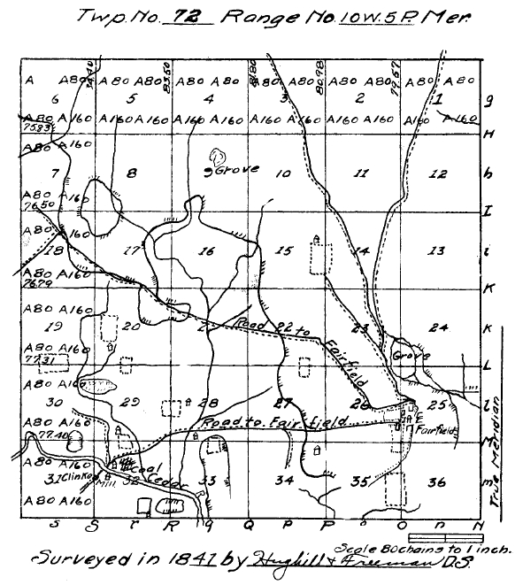
Note: This township was originally named Fairfield Township. It was changed to Center Township on January 6, 1908.
Return to the 1912 History of Jefferson County Contents Page