 |
Liberty Township |
 |
|
|
Liberty Township |
|
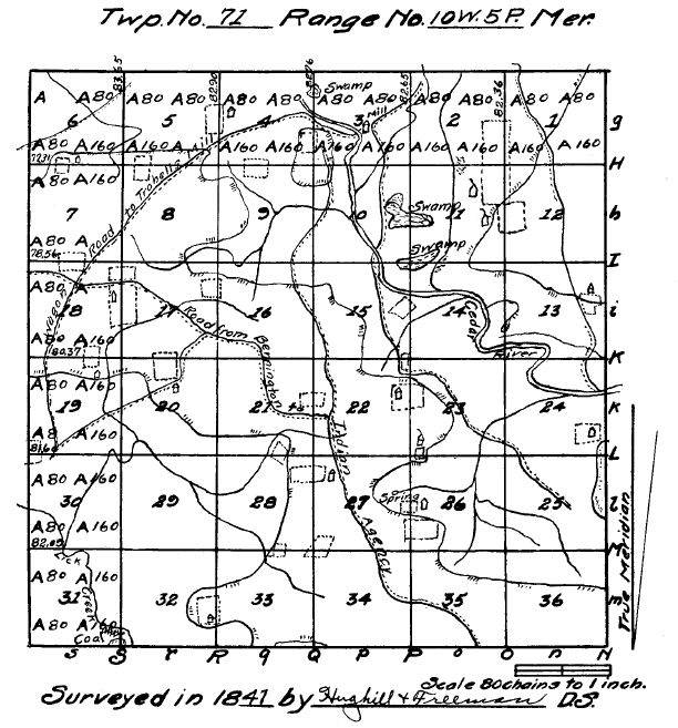
Field Notes of Township No. 71, North of Range No. 10, West of the Fifth Principal Meridian, Iowa Territory. Commenced June 14, 1841. Completed June 25, A. D. 1841. Surveyed by Hugill & Freeman.
North Between sec. 35 & 36.
40.00 Set qr. sec. post in mound Pit 4 Links E.
58.00 Leave prairie.
80.00 Set post Cor. sec. 25, 26, 35 & 36.
W. Oak 10 S 74 E 62.
Do 12 S 61 W 99.
Land gently rolling, 2nd rate, 20 chains on N half timber, W. Oak, R. Oak, Lynn.
Var 9.10.
East Random between sec. 25 36.
47.00 Run 3 links N W.
80.00 Intersect range line 66 S of post.
Land same as last.
W. Oak, Br. Oak, Lynn.
West Corrected between sec 25 36.
20.43 Br. Oak 16 inches diam.
40.00 Set qr. sec. post.
W Oak 16 S 61 E 7½.
Br Oak 12 N 58½ W 33.
41.81 Lynn 16.
80.00 Sec. corner.
Var 9.38 E.
North Between sec. 25 & 26.
21.50 Br. Oak 18.
23.75 Run 3 links N W.
40.00 Set qr. sec. post.
R. Oak 16 S 85 E 23.
Hick. 8 N 51 W 104.
60.15 W. Oak 14 inch diam.
66.82 W. Oak 24 inch diam.
77.75 Hick. 12 inch diam.
80.00 Set post cor. sec. 23, 24, 25, 26.
Lynn 15 S 73 E 35.
Br. Oak 5 S 15 W 35.
Land rolling 2nd rate, W. Oak, Hick.
Var. 9.10.
East Random between sec 24 & 25.
7.50 Road to Troxels Mill N W.
78.00 Enter prairie.
79.95 Intersect range line 132 S of post.
Land same as last.
West Corrected between Sec. 24 25.
25.54 W. Oak 14 inch diam.
39.97½ Set qr. sec. post.
W. Oak 10 N 33 E 26½.
47.20 W. Oak 14.
62.21 W. Oak 18.
68.29 Do 10.
Var. 10.7 E.
North Between sec. 23 & 24.
4.00 Road to Troxells Mill N W.
5.04 W. Oak 16 inch diam.
25.00 Creek 20 Links N E.
26.60 Elm 4 inch diam.
39.20 Birch 20 inch diam.
40.00 Set qr. sec. post.
Birch 20 S 60 W 14½.
Maple 12 N 72 E 70.
44.12 Br. Oak 14.
54.09 W. Oak 24.
80.00 Set post cor sec 13 14 23, 24.
W. Oak, 16 S 14 E 46½.
Do 14 S 58 W 56½.
W. Oak, Hick. Br. Oak, Birch, Elm.
Var. 9.10.
East Random between sec. 13, 24.
13.00 Enter bottom.
29.25 Big Cedar creek 75 links, Course S W.
74.35 Road to Fairfield, N N E.
75.00 Enter prairie.
79.55 Intersect range line 200 S of post.
Land mostly 1st rate bottom W. Oak, B. Oak, Hackbury (sic).
Hickory, B. Walnut.
West Corrected between sec. 13 24.
39.77½ Set quarter sec. post.
W. Elm 40 N 27 E 10.
Hackberry 12 S 22 W 23.
42.65 Do 16.
63.12 B. Walnut 36.
67.81 Elm 6 inch diam.
June 14, 1841.
Var. 10.36 E.
North Between sec. 13 & 14.
11.00 Enter bottom.
12.54 Hick 8 inch diam.
13.00 Big cedar Creek 75 links S E.
Offset W 4.20.
Thence N 45 E intersect line over river.
14.20 Over cedar river.
18.58 Buckeye.
23.75 Enter prairie.
39.50 Bayou 100 links broad.
40.00 On sec. corner in Bayou.
Birch 14 S 21 W 60.
Do 16 S 26 E 24.
Offset from line at 39.50.
Var 9.30 E North 60 E 7.
N 60 W 7 on line.
46.50 Over Bayou S W & N W.
75.00 Leave bottom.
77.00 Leave prairie.
80.00 Set post cor. sec. 12, 13, 23 & 24.
W. Elm 12 N 16 E 82½.
Do 18 N 37 W 175.
Land 2nd rate, part wet bottom, W. Oak, Cottonwood, Elm, Birch.
East Random between Sec. 12 & 13.
55.10 Road from Keosauqua to Fairfield, course South.
78.94 Intersect 280 S of post.
Land rolling, 2nd rate.
West Corrected between Sec. 12, 13.
26.68 Lynn 14.
39.47 Set qr. sec. post.
W. Oak 24 S 60 E 256.
No other near.
78.94 Sec. cor.
Var. 11.10 E.
North Between sec. 11 & 12.
24.50 Enter field.
39.00 Enter prairie.
40.00 Set qr. sec. post.
Elm 8 S 67 W 148.
Br. Oak 10 S 2 W 307.
80.00 Set post in mount, Pit 4 links S.
Cor. sec. 1, 2, 11, 12.
Land rolling, 2nd rate.
Few chains on S½ Jack Oak, Hazel, Apple.
Var 10.45.
June 15th, 1841.
East Random between Sec. 1, 12.
2.50 Leave field.
25.00 Leave prairie.
39.50 Road from Keosaqua (sic) to Fairfield N.
72.40 Ravine S E.
80.14 Intersect Range line 175 S of post.
Land rolling, 2nd rate, not much timber.
West Corrected between Sec. 1, 12.
40.02 Set qr. sec. post.
B. Oak 16 N 46 W 76.
Br. Oak 4 S 36 E 109.
80.04 Sec. corner.
Var 10.15 E.
North Between Sec. 1 & 2.
40.00 Set qr. sec. post.
Br. Oak 18 N 2 E 3.42.
No other near.
44.00 Leave field.
83.36 Intersect N Boundary 60 links W of cor.
Set post cor. sect. 1, 12 (sic - 1, 2?).
Pit 4 links Se.
Rolling prairie, 2nd rate.
Var 9.10 E.
North Between Sec. 34 & 35.
40.00 Set qr. sec. post in mound Pit 4 lks E.
44.25 Road from Burlington to Indian Agincy (sic) N W.
80.00 Set post in mound Cor. to sec. 26, 27, 34 & 35.
Pit 4 lks S.
Land gently rolling, prairie, 2nd rate.
Var 9.10 E.
East Random between Sec. 26 & 35.
24.50 Leave prairie.
45.00 Run 3 links N E.
80.14 Intersect 74 S of post.
Land rolling, 2nd rate, W. Oak, Hick., Elm.
West Corrected between Sec. 26, 35.
14.58 Hick 12 inch diam.
16.75 Elm 6 inch diam.
40.07 Set qr. sec. post.
W. Elm 10 S 66 W 12.
W. Elm 12 N 71 E 19.
00.14 (sic - 80.14) Sec. corner.
Var 9.42.
North Between Sec. 26 & 27.
19.75 Enter field.
32.25 Leave field.
35.50 Set qr. sec. post.
J. Oak 10 N 38½ W 34.
J. Oak 7 N 11 E 53.
42.00 Enter field.
44.00 Leave field.
47.95 Hick 12 inch diam.
50.10 Run in ravine 2 links E from spring, 5 chains W of line.
66.50 Hick 14.
78.00 Enter prairie.
80.00 Set post in mound.
Cor sec. 22, 23, 26 & 29 (sic - 26 & 27), Pit 4 links S.
Rolling 2nd rate, J. Oak, Hick. Undergrowth hazel, Scrub oak.
June 16th, 1841.
East Random between Sec 23, 26.
10.00 Enter field.
15.00 Leave field & prairie.
69.75 Run 3 links N E.
80.00 Intersect 72 S of post.
Land 2nd rate, W. Oak, Br. Oak, Hick, undergrowth, Hazel, R. Oak.
West Corrected.
11.55 R. Lake 36 inch diam.
40.00 Set qr. sec. post.
Br. Oak 10 N 1 E 41.
Br. Oak 12 S 37 E 77½.
80.00 Sec. corner.
Var 9.40.
North Between Sec. 22, 23.
42.41 Enter field.
64.25 Leave field.
66.00 Leave prairie.
67.70 Road to Troxills Mills, N W.
69.16 Elm 18.
80.00 Set post Cor. sec. 14, 15, 22, 23.
Br. Oak 10 S 13½ E 40.
Hick 12 N 59 W 114.
Land rolling 2nd rate--North 20 chains grow good timber, W. Oak, Hick, Br. Oak.
40.00 Set qr. sec. post in mound 4 lks E.
June 17, 1841.
East Random between sec. 14, 23.
79.55 Intersect 184 S of post.
W. Oak, Hick, Br. Oak, West half undergrowth, Hazel, S. Oak, Rolling, 2nd rate.
West Corrected between sec. 14, 23.
7.30 W. Oak 16.
39.77½ Set qr. sec. post.
Hick 8 N 64 W 234.
Br. Oak 12 S 65½ E 218.
79.55 Sec. corner.
Var 10.28 E.
North Between sec. 14 & 15.
27.50 Run 3 links N E.
31.46 Hick 12 inch diam.
40.00 Set qr. sec. post.
Hick 12 S 70 E 65.
R. Oak, 12 N 48½ W 78½.
44.40 Enter S E cor of field.
47.25 Leave field.
60.00 Enter bottom.
61.15 Cedar river course 100 E links Offset 150 W N 45 E over river on line.
75.93 J. Oak 12 inch diam.
78.00 Enter swamp.
80.00 Set post cor. sec. 14, 15, 10, 11.
R. Oak 18 N 25½ E 162.
Hick 14 N 18 W 86.
Land 2nd rate, except swamp, water 1 foot deep.
W. Oak, J. Oak, Hick, Lynn.
Var 9.30 E.
East Random between sec. 11 14.
3.50 Leave swamp.
15.00 Enter prairie.
55.00 Leave bottom & prairie.
79.53 Intersect 249 S of post.
Few chains on W good timber, bottom rather wet, 2nd rate, W. Oak, Hickory.
West Corrected between sec. 11 & 14.
39.76½ Set qr. sec. post in mound, Pit 4 links E.
79.53 Set cor.
Var 11.15 E.
North Between Sec. 10 & 11.
00.50 Leave swamp.
20.23 Br. Oak 6 in dia.
25.00 Enter swamp.
33.00 Leave swamp, water 2 feet deep.
40.00 Set qr. sec. post.
Elm 10 N 68 W 88½.
W. Oak 16 N 48 E 252.
68.36 Br. Oak 7 in diam.
80.00 Set post cor. sec. 2, 3, 10, 11.
Br. Oak 10 S 75 W 13.
Elm 10 S 75 W 38.
S half part swamp, part dry bottom, N half rolling, 2nd rate, W. Oak, Br. Oak, Lynn.
East Random between sec. 2 & 11.
35.00 Leave timber.
58.10 Enter field.
79.91 Intersect 17 N of post. Thinly timbered, 2nd rate, W Oak, Br. Oak.
West Corrected between sec. 2 & 11.
39.95½ Set qr. sec. post in mound. Pit 4 lks E.
79.91 Sect. corners.
Var 10.10 E.
North Between secs. 2 & 3.
19.25 W Oak 6 in diam.
22.70 W Oak 18 in dia.
40.00 Set qr. sect. post.
R. Oak 18 S 52 E 3.
Elm S 79 W 74.
44.55 Creek 10 links wide course S W 2 chains W of line is a coal bank.
47.00 Run 10 S E.
48.00 Run 10 W.
55.32 Hick 12 in dia.
60.90 Road to Fairfield N E.
72.34 W Oak in dia.
82.65 Intersect N boundary 100 links W of cor. set post cor. sec. 2, 3,
Red Oak 12 S 77 W 36.
W. Oak 10 S 54 W 78.
W. Oak, R. Oak, Hick, Elm. Land rolling, 2nd rate.
June 18th, 1841.
V 9.10 E.
North Between sec. 33 & 34.
1.00 Enter prairie.
40.00 Set qr. sec. post in mount (sic). Pit 4 L E.
51.05 Bur 2 links N W.
79.50 Enter field.
80.00 Set post in mound.
Cor sec's 27, 28, 33 & 34, Pit 4 lks S.
Gently rolling, prairie, 2nd rate.
V 9.10, E.
East Random between sec. 27 & 34.
10.07 Leave field.
48.50 Raod N W from Burlington to Indian Agency.
80.10 Intersect 82 S of post.
Land same as last.
West Corrected between sec. 27 & 34.
40.05 Set qr. post in mound, Pit 4 links E.
80.10 Sec. cor.
Var 9.45.
North Between sec's 27 & 28.
3.00 Leave field on W side.
40.00 Set qr. sec. post in mound, Pit 4 L E.
69.70 Enter field.
76.80 Leave same.
88.00 (sic - at 80.00?) Set post in mound, Pit 4 S.
Cor sec. 21, 22, 27 & 28. Land same as last.
Var 9.10 E.
East Random between sec. 22 & 27.
19.20 Road from Burlington to Indian Agency.
80.06 Intersect 85 S of post.
Land rolling, prairie, 2nd rate.
West Corrected between sec. 22 & 27.
40.03 Set qr. sec. post in mound, Pit 4 links E.
80.06 Sec. cor.
Var 9.46 E.
North Between Sec. 21 & 22.
17.00 Run in ravine 2 links W.
33.75 Road from Burlington to Indian Agency.
40.00 Set qr. sec. post in mound, Pit 4 lks E.
44.15 Enter field.
52.90 Leave same.
80.00 Set post in mound Cor. sec. 15, 16, 21 & 22.
Pit 4 links S.
Gently rolling, prairie, 2nd rate.
Var 9.10 E.
East Random between sec. 15 & 22.
6.25 Road to Troxells mills, N W.
40.00 Leave prairie.
55.00 Run and ravine 2 links N E.
60.50 Road to Troxells Mill N W.
65.15 Enter field.
77.20 Leave same.
79.65 Intersect 193 S of post. W half rolling prairie, E half W. Oak, B. Oak, J. Oak, Hick.
On S E qr of S E qr of Sec. 22 is a coal bank strata 3 feet thick.
West Corrected between sec. 15 & 22.
39.82½ Set qr. sec. post.
J. Oak, 6 S 40 E 86½.
J. Oak 4 S 36 E 80.
79.65 Sec. cor.
Var 10.10 E.
West (sic - North) Between sec. 15 & 16.
40.00 Set qr. sec. post in mound at road to Troxells mills, N W Pit 4 lks E.
65.00 Leave prairie.
80.00 Set post cor. sec 9, 10, 15 & 16.
J. Oak 16 N 33 E 150.
J. Oak 16 N 18 W 59.
Land rolling, 2nd rate, 15 chains on N½ J. Oak, Hazel.
June 19th, 1841.
Var 9.45.
East Random between sec. 10 & 15.
49.00 Road to Troxill's Mill N E.
54.00 Cedar river 70 links Course S E.
68.00 Enter swamp.
79.87 Intersect 84 S of post.
E half part good bottom, Part swamp.
W half rolling, W. Oak, Br. Oak, Elm, Hick, B. Walnut.
West Corrected between sec. 10. & 15.
39.93 Set qr. sec. post.
W. Oak 18 N 11 E 36.
Br. Oak 12 S 49 W 72.
50.02 Br. Oak 10 in diam.
79.87 Sec. cor.
10.24 E.
North Between sec. 9 & 10.
16.08 Hick 7 in diam.
37.75 Road to Troxells Mill Course N E.
40.00 Set qr. sec. post.
W. Oak 18 S 30½ W 46.
Elm 12 N 43½ E 65.
42.25 Enter bottom
44.75 Run 6 course E.
68.50 Enter prairie.
80.00 Set qr. sec. cor. 3, 4, 9 & 10.
Elm 18 N 51 W 478½.
Elm 16 S 66½ W 434½.
Few chains on S half 1st rate, bottom, N half rolling 2nd rate, W. Oak, Elm, Br. Oak, Lynn.
V 9.45 E.
East Random between Sec. 3 & 10.
6.00 Enter bottom.
13.03 Road to Troxells mill N W.
28.69 Leave prairie.
39.69 Cedar river 70 links Course S E.
Offset S 3.76.
N 45, E over river.
55.03 Run 4 links Course S.
55.75 Road to Troxells mill Course N & leave bottim (sic).
80.06 Intersect 10 N of post.
Part bottom, part rolling.
(West, corrected between 3 & 10)
00.90 Br. Oak 14 in dia.
7.37 Hick 12 in dia.
40.03 Set qr. sec. post in cedar river left bank.
B. Walnut 8 S 69 E 81.
Birch 14 N 9 E 50.
On S E of sec. 3 is a saw & flouring mill and coak bank apparently extensive.
North Between sec. 3 & 4.
11.20 Enter field.
31.44 Leave field and prairie.
38.50 Road from Troxells Mill N W.
39.91 Cedar river 75 links E.
40.00 Qr. sec. cor. in river inaccessible.
Birch 18 S 27 E 12.
Elm 14 S 85 W 46.
39.75 Offset W 120 chains.
Offset N 45 E over river on line.
45.00 Enter prairie.
61.00 Swamp.
82.76 Intersect boundary N 58 W of cor. set post in mound Pit 4 links S.
W. Oak, Lynn & Birch 2nd rate, bottom rather wet.
June 21st, 1841.
Var 9.10 E.
North Between Sec. 32 & 33.
16.15 Hick 12 in dia.
23.18 * Enter field & prairie.
43.16 Leave field.
53.00 Leave prairie.
71.66 J. Oak 12 in dia.
80.00 Set post cor. sec. 28, 29, 32 & 33.
J. Oak 12 S 42 E 30.
Hick 14 S 36½ W 35.
Rolling 2nd rate, 25 chains on N½ W. Oak, Hick., J. Oak.
Var 9.10 E.
* Set ¼ sec. post in mound Pit 4 links E.
East Random between sec. 28 & 33.
44.20 Run 3 links Course N W.
56.65 Enter prairie & Field.
61.34 Leave field.
79.00 Enter field.
80.16 Intersect 90 S of post, W half W. Oak, Hick., J. Ok (sic), Hazel, apple.
E half part prairie, all gently rolling, 2nd rate.
West Corrected between sec. 28 & 33.
40.08 Set qr. sec. post.
J. Oak, 8 N 13 E 9.
J. Oak, 5 S 29 E 21.
63.78 Elm 4 in dia.
80.16 Sec. cor.
Var 9.49 E.
North Between Sec. 28 & 29.
19.16 Br. Oak 12 in dia.
29.90 Run 4 links N W.
40.00 Set qr. sec. post.
W. Oak 17 S 78½ W 143.
Hick. 10 N 74½ E 165.
65.03 Br. Oak 16 in dia.
66.00 Run 8 links course W.
Br. Oak 10 S 50 E 335.
B. Oak 18 N 63 E 309.
Rolling 2nd rate. Timber W B & Bur Oak.
Var 9.10 E.
East Random between 21 & 28.
46.00 Run S S W 5 links.
47.80 Enter field at W cor.
65.15 Leave field & enter prairie.
79.43 Intersect 126 S of post.
Land rolling, 2nd rate, W. Oak, Br. Oak, Hazel, Plum, S. Oak, 16 chains of E half prairie.
West Corrected between Sec. 21 & 28.
39.76½ Set qr. sec. post.
Hick 10 S 69 E 41.
Br. Oak 14 N 8 W 201.
79.43 Sec. cor.
Var 10.04 E.
North Between Sec. 20 & 21.
26.00 Enter prairie.
40.00 Set. qr. sec. post near thicket.
J. Oak 4 S 71 E 104.
J. Oak 3 N 20 W 48.
80.00 Set post in mound.
* Cor. sec. 16, 17, 20 & 21.
Land rolling, 2nd rate, 26 chains on S half Hazel plum, apple, ash, etc.
V 9.35 E.
* Pit of mound 4 links South.
East Random between 16 & 21.
41.25 Road from Burlington to Indian Agency Course N W.
79.40 Intersect 125 S of post.
Gently rolling, prairie, 2nd rate.
West Corrected between sec. 16 & 21.
39.70 Set qr. sec. post in mound Pit 4 links E.
79.40 Sec. cor.
June 22nd, 1841.
Var 10.29.
North Between sec. 16 & 17.
16.30 Road from Burlington to Indian Agency N W.
37.60 Run 2 links N W.
40.00 Set qr. sec. post in mound Pit 4 links E.
40.25 Enter field.
65.60 Leave same.
68.50 Leave prairie.
80.00 Set post cor. sec. 8, 9, 16, 17.
Br. Oak 12 N 55 1-3 W 94.
Br. Oak 14 S 37½ E 26.
Rolling prairie, 2nd rate, few chains on N hazel, plumb (sic), Br. Oak, W. Oak.
Var 10.12 E.
East Random between sec. 9, 16.
19.00 Run 8 links S E.
20.00 Run 8 links N E.
36.00 Run 2 links N.
71.20 Road to Troxell's Mill N.
80.37 Intersect 28 N of post.
Br. Oak, W. Oak, Elm, rolling, 2nd rate.
West Corrected between sec. 9 & 16.
40.18½ Set qr. sec. post.
Br. Oak 10 N 6½ W 24½.
Elm 12 S 72 W 51.
43.56 Br. Oak 14 in dia.
80.37 Sec. cor.
Var 10.00 E.
North Between sec. 8 & 9.
4.75 Run 3 links E.
17.50 Enter prairie.
40.00 Set qr. sec. post in mound Pit 4 links E.
79.00 Leave prairie.
80.00 Set post cor. sec. 4, 5, 8 & 9 in mound pit 4 links S.
Rolling prairie, 2nd rate. 17 chains on S half, Hazel, Plumb (sic), apple, etc.
Var 9.30 E.
East Random between Sec. 4 & 9.
19.00 Run 2 links E S E.
33.52 Enter field.
46.25 Leave same.
77.00 Enter prairie in bottom.
80.13 Intersect 54 S of post.
Land rolling, 2nd rate, Hazel, S. Oak, Thorn, not much timber.
Var 9.53.
West Corrected between sec. 4 & 9.
40.06½ Set ¼ Sec. post in mound Pit 4 links East.
80.13 Sec. cor.
North Between sec's 4 & 5.
19.20 Road to Fairfield N E.
24.50 Road to Indian Agency W.
30.00 Enter field.
40.00 Set qr. sec. post Br. Oak 12 N 50½ W 62, no other near.
50.30 Leave field.
61.99 Br. Oak 16 in diam.
82.90 Intersect N boundary 76½ W of cor. sec. post cor. sec. 4 & 5.
W. Oak 10 S 17 E 67.
B. Oak 16 S 84 W 43.
Rolling 2nd rate, S half hazel, N half good timber.
W. Oak, Br. Oak, Hick., B. Oak.
June 23, 1841.
Var 9.10 E.
North Between sec's 31 & 32.
11.15 Leave prairie.
15.10 Lich Creek (sic) 20 links S E.
23.37 Maple 14 in diameter, leave bottom.
40.00 Set qr. sec. post.
W. Oak 17 N 73 E 53.
W. Oak 12 S 67½ W 61.
58.86 W. Oak 24 in dia.
71.63 W. Oak 14 in dia.
80.00 Set post cor. sec. 29, 30, 31 & 32.
W. Oak 16 S 87 W 92½.
Hick. 16 S 16 W 102.
Land rolling 2nd rate. W. Oak, Hick., Br. Oak, Mple (sic), on S E qr. sec. 31 is a coal bank strata 4 feet thick.
East Random between 29 & 32.
79.50 Intersect 12 S of post, rolling, 2nd rate, W. Oak, Br. Oak, Hick.
West Corrected between Sec. 29 & 32.
32.01 Br. Oak 16 in diam.
39.75 Set qr. sec. post.
W. Oak 8 S 46 E 56.
Hick. 10 N 10 E 113.
79.50 Sec. cor.
Var 10.00 E.
West Random between sec. 30 & 31.
19.10 Ravine S E.
21.50 Leave same.
35.00 Enter bottom.
40.00 Lick Creek 60 links S of line.
49.81 Lick Creek S 20 links wide.
82.09 Intersect W boundary 113 N of post.
B. Oak 16 N 71 E 53.
B. Oak 12 S 50½ W 8.
Land rolling, 2nd rate, W. Oak, B. Oak, Hick., Br. Oak.
East Corrected between Sec 30 & 31.
10.26 W. Oak 18 in dia.
22.22 W. Oak 16 in dia.
42.09 Set qr. sec. post in Lick creek.
Hick 16 N 12 E 34.
Hick 12 S 50 W 67.
44.46 Br. Oak 17 in dia.
82.09 Sec. cor.
Var 9.58 E.
North Between sec's 29 & 30
6.08 Br. Oak 8 in dia.
29.20 Hick. 7 in dia.
40.00 Set qr. sec. post.
W. Oak 10 N 59 W 6.
Br. Oak 16 N 65 E 89.
59.26 W. Oak 12 in dia.
67.49 W. Oak 14 in dia.
78.90 Lick Creek 15 links W.
80.00 Set post cor, sec. 19, 20, 20 & 30.
B. cherry 10 S 76 W 5.
Elm 5 S 59 E 7.
Land part rolling, part bottom, 2nd rate. W. Oak, Br. Oak, Cherry, Lynn, etc.
Var 9.31 E.
East Random between sec. 20 & 29.
1.55 Lick Creek 15 linis (sic) S W.
20.90 Lick Creek 15 N W.
79.46 Intersect 126 S of post.
Land rolling, 2nd rate, W half W. Oak, Br. Oak, Hick., Lynn, East half, Hazel, Scrub Oak.
West Corrected between sec 20 & 29.
39.73 Set. qr. sec. post.
W. Oak N 53 E 77.
Double W. Oak S 17 W 165½.
57.31 Hick. 12 in dia
59.65 Lynn 6 in dia.
79.46 Sec. cor.
June 24th, 1841.
Var 10.24 E.
West Random between Sec's 19 & 30.
.70 Lick Creek 10 links N W.
3.30 Lick Creek 8 links S & W.
65.00 Road from Troxill's S W.
71.62 Enter field.
81.60 Intersect W boundary 93 N of post.
W. Oak 12 N 85 E 6½.
R. Oak 24 S 18 E 2.15.
Land rolling, 2nd rate, W. Oak, R. Oak, Br. Oak, Undergrowth, Hazel, S. Oak, Hick.
East Corrected between sec. 19 & 30.
41.60 Set qr. sec. post
Hick 16 S 78 W 61.
Hick 18 N 59 W 186.
81.60 Sec. cor.
Var. 10.20 E.
North Between sec. 19 & 20.
17.72 W. Oak 16 in dia.
20.59 Br. Oak 8 in dia.
26.60 Creek 10 course S E.
30.80 Road to Troxells mill N E.
40.00 Set qr. sec. post.
W. Cherry 2 S 83 E 21.
Hick 16 N 60 W 269.
70.00 Enter prairie.
80.00 Set post in mound pit 4 links S cor sec. 17, 18, 19 & 20.
Land rolling, 2nd rate.
Few chains on S half good timber, W. Oak, Br. Oak, Hick., etc. N half Hazel, S Oak, Cherry, Apple, Thorn --
except few chains prairie.
Var 9.59 E.
East Random between sec. 17, 20.
25.80 Enter field.
41.25 Leave field.
51.25 Road to Troxells Mill N E
80.05 Intersect 7 N of post.
Gently rolling, 2nd rate prairie.
West Corrected between sec. 17, 20.
40.02½ Set qr. sec. post in mound pit 4. links E.
80.05 Sec. cor.
Var 9.56
West Random between Sec. 18 & 19.
2.40 Run 2 links S S E.
20.12 Enter field.
38.60 Leave same.
66.25 Road north from Portland.
80.37 Intersect W boundary 7 links N of post.
Land 2nd rate.
East Corrected between Sec. 18 & 19.
40.37 Set qr. sec. post in mound Pit 4 links E.
80.37 Sec. cor.
Var 10.02 E.
North Between Sec. 17 & 18.
18.00 Run 2 links S S W.
20.90 Enter field.
40.00 Set qr. sec. post in mound, Pit 4 links E.
65.88 Leave field at Road W to Indian agency.
67.10 Enter field.
74.60 Leave field.
80.00 Set post in mound at cor. sec. 7, 8, 17 & 18.
Pit 4 links S. Good prairie.
Var 10.12 E.
East Random between sec. 8 & 17.
23.50 Run 2 links E S E.
50.25 Run 2 links E N E.
50.25 Leave prairie.
80.15 Intersect 83 N of post.
Land 2nd rate, 30 chains on E half, Hazel, S. Oak, Thorn, Apple.
West Corrected between sec. 8 & 17.
40.07½ Set qr. sec. post in mound Pit 4 links E.
80.15 Sec. cor.
Var 0.36 E.
June 25th, 1841.
West Random between sec. 7, 18.
23.75 Road to Portland S W.
24.00 Enter field.
57.75 Leave field.
58.00 Road N W.
78.66 Intersect W boundary 28 S of post.
Land gently rolling, good prairie.
East Corrected between sec. 7 & 18.
38.56 Set qr. sec. post in mound Pit 4 links E.
78.56 Sec. cor.
Var 10.00 E.
North Between sec. 7 & 8.
25.50 Road to Fairfield N E.
40.00 St (sic) qr. sec. post in mound pit 4 links E.
80.00 Set post in mound cor. sec. 5, 6, 7, & 8 Pit 4 links S.
Gently rolling prairie, 2nd rate.
Var 9.30 E.
East Random between sec. 5 & 8.
7.50 Enter field.
16.85 Leave same.
59.00 Road from Philadelphia to Fairfield N E
79.00 Enter hazel thicket.
79.97 Intersect 61 S of post.
Land same as last.
West Corrected between Sec. 5 & 8.
39,98½ Set qr. sec. post in mound Pit 4 links E.
79.97 Cor. sec.
Var 10.00 E.
West Random between sec's 6 & 7.
7.25 Run 2 links N.
42.50 Enter field.
59.33 Leave same.
62.80 Leave prairie.
77.31 Intersect west boundary 35 N of post.
W. Oak 6 N 47 E 82.
Elm 12 S 70½ E 126.
Land same as last, except few chains of W half.
Hazel. S. Oak, Apple, etc.
Var 9.45 E.
East Corrected between sec. 6 & 7.
37.31 Set qr. sec. post in mound Pit links E.
77.31 Sec. cor.
North Between secs 5 & 6.
10.50 Leave prairie.
21.20 Bur 3 links N N E.
37.10 Run 2 links Crs West.
00 00 Set qr. sec. post. (At 40.00?)
Hick 16 S 14 E 36.
J. Oak 4 N 81¼ W 12½.
60.50 Road to Indian Agency S W.
76.82 Intersect S W cor of house.
83.65 Intersect N boundary 47 E of cor.
Set post cor. sec 5 & 6.
R. Oak 16 S 31 W 32.
J. Oak 4 S 72 E 17½.
Land rolling, 2nd rate, S half Hazel, S. Oak, Apple thorn, Plumb (sic), N half W. Oak, J. Oak, Hick.
June 26th, 1841.
Var 9.10 E.
This township is rich soil, mostly part rolling, The timber on Lick Creek & part of Cedar and S E part of this township is mostly W. Oak, Br. Oak, Hick., B. Oak, Lynn, J. Oak, Elm, some parts undergrowth, Hazel, scrub Oak, Apple, Plumb, Thorn etc., and not much timber. On south east qr. section on Cedar River is a saw and flouring mill, also on left bank of said River is a Coal Bank, apparently extensive.
I hereby certify that in pursuance of a contract with George W. Jones, Surveyor General of the United States for Wisconsin and Iowa, bearing date, the 1st day of April, 1841, and in strict conformity to the laws of the United States, and the instructions of said Surveyor General, I have surveyed and subdivided into sections, Township No 71 in Range No. 10 W of 5th mer. in the territory of Iowa. And I do further certify that the following is a true copy of the original field Notes of said Survey and subdivision, executed as aforesaid and Certified this 12th day of August, 1841.
Thomas Hugill,
James E. Freeman,
Dep. surveyors.
(Signed by)
Ira Cloflin
David Corss
Chainmen.
Hugh R. Skinner
Marker.
Return to the 1912 History of Jefferson County Contents Page