 |
Walnut Township |
 |
|
|
Walnut Township |
|
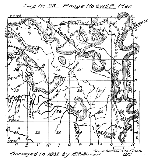
Field Notes of Township No. 73, North of Range 8, West of the Fifth Principal Meridian, Wisconsin Territory. Surveyed by E. F. Lucas. Commenced September 18, 1837. Completed November 17, 1837.
North Between Sections 35 & 36 Var 8° 50'.
2.37 Bur Oak 18 in diameter.
8.70 Entermarsh (sic) E & W.
12.84 Leave marsh.
24.23 Bur Oak 20 in diameter.
28.00 Elm 26 in diameter.
40.00 Set quarter section post.
Bearings: Ironwood 7 S 30½ W 11.
Lynn 10 N 85½ E 51.
46.43 Hickory 18 in diameter.
48.77 Bur Oak 14 in diameter.
49.53 Lynn 20 in diameter.
71.35 Brook 3 lks S W E ch. a house occupied by Johnson Hampton a setler (sic).
80.00 Set post corner sections 25 26 35 & 36.
Red Oak 22 S 22 E 18.
Red Oak 26 N 54 W 39.
Land gently ascending, first rate, Bur Oak, Walnut, Sugar.
East Random between sections 25 & 36 Var 10° 30'.
53.50 Descend bluff.
55.69 Enter bottom.
75.41 Skunk river bold current, course South, low banks.
79.96 Over river.
80.80 Intersect N & S line 73 lks South of post.
Land level, to the bluff Walnut, Bur Oak, Lynn, Sugar, first rate, thence the bottom level, first rate. Walnut,
Hackberry, Buckeye, Elm -- along the river, Cottonwood.
West Corrected between Sections 25 and 35 Var 11 00'.
1.00 Set meander post on left bank of Skunk river.
Cottonwood 15 S 5 E 14.
Do 18 N 14 W 46.
5.39 Set post on right bank of skunk river.
Bur Oak 4 S 45 W 26.
6.75 Hickory 14 in diameter.
13.97 Hackberry 10 in diameter.
40.40 Set quarter section post.
Elm 11 S 11½ W 24.
W. Oak 14 N 69½ W 13.
45.14 Ash 18 in diamter.
51.02 B. Oak 22 in diameter.
80.80 Section corner.
Joseph Zurk a setler on the N E qr of Section 36.
April 18, 1837. (sic - September?)
North Between sections 26 and 25 Var 8° 50'.
3.19 Hickory 14 in diameter.
22.88 Lynn 10 in diameter.
40.00 Set quarter section post.
Red Oak 20 N 72½ W 7.
Hickory 6 N 80 W 5.
40.99 Ash 16 in diameter.
41.92 Elm 10 in diameter.
47.57 Red Oak 36 in diameter.
67.68 Sugar 8 in diameter.
80.00 Set post corner sections 23, 24, 25 & 26.
Elm 10 S 54½ W 46.
Sugar 36 N 37 E 90.
Land first rate, gently rolling, Walnut, Sugar, Ash, Lynn, Red Oak. Andrew Turner, a setler on the S E qr of
sec. 26 small improvement.
East Between Sections 24 & 25 Var 10 30'.
10.25 Enter bottom.
12.17 Elm 24 in diameter.
14.20 Indian trail N & S.
15.99 Pond clear water from 2 to 10 feet deep. Offset 1.50 lks South.
12.01 chain East.
North 1.50 lks reduced off sett. (sic)
37.90 Elm 26 in diameter.
40.00 Set quarter section post.
Ash 12 N 89 W 12.
Hickory 8 S 28 E 59.
48.12 Elm 30 in diameter.
75.50 Intersect right bank Sk. R. Cours S E.
Set post Sycamore N 67 W 31.
Hackberry 6 S 80 W 29.
Width of river at this intersection 6 ch. 35 lks by Inganometry (sic - Triganometry).
Land first rate, Hackberry, Elm, etc.
Sept. 26, 1837.
North Between Sections 23 and 24 Var 8° 50'.
00.91 Red Oak 26 in diameter.
3.10 Brook 3 lks East.
10.18 Bur Oak 13 in diameter.
40.00 Set quarter section post.
Hickory 10 S 17½ E 97.
Do 12 S 30 W 90.
62.70 W. Oak 24 in diameter.
63.30 W. Oak 20 in diameter.
80.00 Set post corner sections 13, 14 23 & 24.
W. Oak 28 S 45 E 10.
W. Oak 24 N 47 W 68.
Land 2nd rate, level thinly timbered, with W. Oak. Bur Oak, Lynn, Hickory.
East Random between sections 15 & 24 Var 10 30'.
5.74 Brook 3 lks S of E.
8.63 Indian trail N and S.
8.00 Descend bluff to pond or old bed of river N & S.
9.25 Enter pond or old bed of river.
14.54 Leave old bed or pond.
16.70 Intersect small Lake, old channel or Pond N & S.
28.35 Over Lake or Pond, Measurement wrought by trigonometry.
45.65 Indian Trail, N & S.
56.47 Intersect right bank Skunk river. Course E of South.
Current bold, banks low on W side.
61.04 Over river.
80.83 Intersect Range line. 75 lks South of post.
Land W of River Wet, East of river, first rate bottom.
West Corrected between Sections 13 & 24 Var 11° 02'.
9.33 Hackberry 8 in diameter.
18.54 Elm 10 in diameter.
19.95 Set post on left bank, Skunk River.
Ash 6 N 68 E 16.
Do 7 8 (sic - S?) 47 E 10.
24.34 Over river measurement by Trigonometry set post on right bank.
25.65 Maple 10 in diameter.
27.45 Cottonwood 18 in diameter.
40.41½ Set quarter Section post.
Bur Oak 12 S 73 E 36.
Do 18 N 10 W 22.
80.83 Section corner.
The bal, of this line is mostly a pond.
North Between Section 13 and 14 8° 50'.
00.56 W. Oak 14 in diameter.
2.50 Brook 4 lks East.
13.20 W. Oak 18 in diameter.
23.58 Bur Oak 20 in diameter.
26.54 Indian trail E and W.
39.24 Lynn 22 in diameter.
40.00 Set quarter section post.
Double Elm 10 S 70 E 17.
Red Oak 8 S 26 W 49.
40.35 Brook 15 lks E.
41.04 Bur Oak 20 in diameter.
47.60 Bur Oak 16 in diameter.
80.00 Set post corner section 11 12 13 14
Elm 20 N 22 W 37.
Do 16 N 65 E 29.
Land gently rolling, 2nd rate S½. W. Oak, Lynn, Bur Oak, N½ Bur Oak, J. Oak, Plum Aspen, Hazel Plum, Thorn,
Crabapple.
East Random bettween (sic) sections 12 and 13 Var 10 30'.
00.34 Brook 8 lks S E.
24.00 Enter bottom N & S.
58.40 Indian trail N & S.
58.98 Wigwam.
59.56 Intersect right bank of Skunk river, course South bold current.
14.45 Over river (sic - at 74.45?)
80.47 Intersect Range line 25 lks South of post.
Land mostly level first rate, Elm, Hackberry, Hickory, Locust etc.
West Corrected between Section 12 and 13 Var 10° 40'.
00.99 Ash 6 in diameter.
9.75 Elm 24 in diameter.
15.71 Set post on left bank Skunk river.
Elm 6 N 74 E 7½.
Do 20 S 26 W 15½.
20.60 Over river measurement by Trigonometry, set post on right bank.
B. Oak 12 N 73 W 44.
Red Oak 20 S 69 W 125.
21.57 Bur Oak 18 in diameter.
40.23½ Set quarter section post.
Elm 14 N 60½ E 13.
Elm 10 S 3 E 26½.
42.11 Elm 16 in diameter.
80.47 Section corner.
North Between Section 11 and 12 Var 8° 50'.
3.30 Brook 15 lks S E.
3.52 Cottonwood 20 in diameter.
32.00 Hickory 15 in diameter.
40.00 Set quarter section post.
Hickory 18 S 16½ E 1.59.
Bur Oak 20 N 5 E 1.61.
80.00 Set post corner section 1 2 11 & 12.
Blk Oak 8 N 46 E 9.
Red Oak 12 N 75 W 16.
Land 2nd rate, gently rolling. J. Oak, Bur Oak, Hickory, Lynn, Elm, Plum, Thorn Hazel Briers, Vines etc.
East Random between Sections 1 and 12 Var 10 30'.
4.90 Brook 4 lk S of E.
28.19 Brook 5 lks N of E.
32.50 Descend bluff.
38.00 Enter bottom N & S.
45.92 Intersect Rt bank Skunk river-- bold current course S E.
52.27 Over river.
74.50 Enter prairie N & S.
80.86 Intersect range line 14 lks S of post Lane to the bottom 3rd rate.
Hilly, thence first rate. Bur Oak, Hackberry, Elm, B. Walnut.
West Corrected between Section 1 and 12 Var 10° 35'.
9.96 Bur Oak 12 in diameter.
10.03 Do 10 in diameter.
28.73 Set post on left bank Skunk river.
Sycamore 40 N 2 E 57.
Cottonwood 20 S9 W 19.
34.94 Over river, measurement by Trigonometry, set post in right bank.
Bur Oak 8 N 12 W 10½.
Red Oak 18 S 37 W 44.
39.43 Ash 4 in diameter.
Elm 9 S 20 W 9.
Do 10 N 11 W 38.
80.86 Section corner.
North Between Sections 1 and 2 Var 2° 50'.
3.49 Brook 3 lks E.
5.20 Hickory 16 in diameter.
21.55 Hickory 6 in diameter.
40.00 Set quarter section post.
Hickory 6 N 57 W 48.
Hickory 10 S 8 E 39.
48.35 Red Oak 36 in diameter.
67.34 Brook 3 lks East.
79.87 Enter bottom.
80.78 Intersect North boundary of Township 46 links West of post. Set post corner section 1 2.
Hickory 20 S 76 W 14½.
W. Wlnut (sic) 9 S 22½ E 31.
Land 2nd rate, rolling, Hickory B. Oak Lynn, Elm, Hazel, Briers, Vine etc.
Sept. 28, 1837.
North Between section 34 and 35 Var 8° 50'.
2.67 W. Oak 14 in diameter.
13.02 W. Oak 10 in diameter.
25.95 W. Oak 9 in diameter.
40.00 Set quarter section post.
W. Oak 12 N 73½ E 22.
W. Oak 22 N 30 W 65.
49.00 W. Oak 20 in diameter.
66.16 B. Oak 10 in diameter.
80.00 Set post corner sections 26 27 34 35
Elm 12 S 31 W 13.
Bur Oak 14 N 46 E 42.
Land 2nd rate rolling, W. Oak, B. Oak, Red Hickory, Hazel, etc.
East Random between sect. 26 & 35 Var 10° 30'.
15.06 Creek 25 lks South.
80.34 Intersect N & S line 2 links South of ost.
Land W½ 2nd rate, gently rolling, W. Oak, Bur Oak Hickory, Hazel Plum, Vine--E½ rolling, first rate. Sugar,
Walnut, Sugar, Lynn, Ash, Elm, Walnut vines.
West Corrected between Sections 26 and 35 Var same.
26.60 Sugar 12 in diameter.
40.17 Set quarter section post.
Bur Oak 12 N 66½ E 12.
Do 9 S 84½ W 27.
40.64 Bur Oak 14 in diameter.
41.15 Lynn 12 in diameter.
61.72 W. Oak 24 in diameter.
John Vorhies a setler on N W qtr. of 35.
80.34 Section corner.
North Between Sections 26 and 27 Var 8° 50.
1.10 Bur Oak 12 in diameter.
11.05 W. Oak 4 in diameter.
40.00 Set quarter section post.
Bur Oak 4 N 69 E 35.
Aspen 6 N 8½ W 18.
50.40 Creek 60 lks East.
52.29 Enter bend of creek.
54.10 Leave bend of creek.
57.43 Creek 100 lks W.
67.97 Lynn 8 in diameter.
73.09 Creek 80 links East.
80.00 Set post corner section 22 23 26 27.
Hickory 10 S 55 W 15.
Bur Oak 6 N 50 E 35.
Land S½ rolling 2nd rate W. Oak Br. Oak, J. Oak, Plum Hazel, Crab, thorn N½ bottom, Walnut, Lynn, sugar,
Elm, Hickory.
Sept. 27, 1837.
East Random between Sections 23 and 26 Var 10° 30'.
5.28 Brook 3 links South.
77.37 Brook 4 links North.
80.32 Intersect N & S line 69 lks S of post.
Land W½ 3rd rate, broken. W. Oak, Red Oak, Hickory, E½ gently rolling, W. Oak, Lynn, Sugar, Elm, on the
last 15 ch. and around the corner is a beautiful sugar Camp, intersperced (sic) with many wigwams where the
Indians from an appearance have made quantities of sugar.
West Corrected between sect. 23 and 26 Var 11°.
11.72 Sugar 8 in diameter.
14.64 Sugar 12 in diameter.
40.16 Set quarter section post.
W. Oak 11 S 61½ E 74.
Red Oak 10 N 29 E 36.
50.77 Hickory 8 in diameter.
80.32 Section Corner.
North Between Sections 22 and 23 Var 8° 50'.
00.60 Bur Oak 9 in diameter.
11.97 W. Oak 20 in diameter.
32.97 W. Oak 18 in diameter.
40.00 Set quarter section post.
Elm 18 N 30½ E 40.
Bur O 4 S 60 W 41.
41.97 Hickory 8 in diameter.
45.20 Brook 4 lks S W.
47.16 Hickory 10 in diameter.
57.28 Bur Oak 18 in diameter.
65.02 Brook 2 lks E of S.
80.00 Set post corner sections 14 15 22 23.
Bur Oak 7 S 62 W 16.
Hickory 10 S 57 E 38.
Land 2nd rate, broken W. Oak, Bur Oak, Some Lynn along the brook. Hazel Briers Vines.
East Random between Sections 14 and 23 Var 10° 30'.
80.09 Intersect N & S line 47 lks S of Post.
Land 2nd rate, rolling, thinly timbered. W. Oak, Hickory, Bur Oak, Hazel, J. Oak, Briers, etc.
West Corrected between sections 14 and 23 V 10° 50'.
2.92 W. Oak 24 in diameter.
9.82 B. Oak 16 in diameter.
3.84 Do Do 14 in diameter.
40.04½ Set quarter section post.
J. Oak 10 N 57 W 18.
J Oak 8 S 66 W 40.
73.25 Hickory 10 in diameter.
76.69 Red Oak 20 in diameter.
80.09 Section corner.
North Between sections 14 and 15 Var 8° 50'.
4.99 Hickory 6 in diameter.
16.05 Double Bur Oak 16 in diameter.
40.00 Set quarter section post.
Elm 6 S 20 W 6.
Do 8 N 83 E 18.
45.87 Elm 6 in diameter.
48.08 Do 10 in diameter.
51.92 J. Oak 9 in diameter.
55.17 Elm 12 in diameter.
59.57 J. Oak 14 in diameter.
80.00 Set post corner sections 10 11 14 15.
J. Oak 16 N 7 W 18.
J Oak 8 N 12 E 64.
Land rolling S½ 2nd rate, Hickory, J. Oak, Bur Oak Hazel briers,--N½ first rate 1 Elm, Lynn, J. Oak, Aspen,
Plum, Thorn, Hazel, Briers.
East Random between Section 11 and 14.
1.00 Leave timber and enter prairie.
15.00 Brook 4 lks N of E.
21.62 Indian trail N & S.
29.00 Leave prairie and enter small timber.
79.80 Intersect N & S line 35 lks south of post.
Land gently rolling, 1st rate. first 20 ch. prairie.
Next 40 chs J. Oak Aspen, plum thorn--Last 30 chs (sic - last 20 chs?) Lynn, Hickory, Elm, etc. Hazel.
West Corrected between Sections 11 and 14 Var 10° 45'.
8.88 Hickory 13 in diameter.
39.90 Set quarter section post.
Hickory 8 S 20 E 53.
Elm 6 N 14 W 98.
79.80 Section corner.
North Between sections 10 and 11.
8.50 Leave brush and enter prairie.
12.30 Brook 3 lks E.
21.80 Indian Trail E & W.
31.00 Leave prairie and enter brush.
40.00 Set quarter section post.
J. Oak 3 S 71 W 41.
Aspen 6 N 8 E 1.40.
42.50 Aspen 8 in diameter.
64.00 Enter prairie.
65.14 Brook 4 lks East.
80.00 Set post in mound in prairie Pit 4 links S.
Corner sections 2 3 10 11.
Land gently rolling S½, first rate. N½ 2nd rate.
Brush Hazel, Plum, thorn Aspen, J. Oak.
Prairie rolling, rosin weed, wire grass.
Sept. 30, 1837.
East Random between sections 2 and 11.
8.00 Enter small grove N & S.
14.50 Leave grove.
27.00 Enter small grove N & S.
30.50 Leave grove.
67.00 Leve prairie & enter timber.
79.59 Intersect N & S line 30 lks S of post.
Land gently rolling, 2nd rate, first 65 ch. prairie with small grove, intersperced (sic) and short Hazel.
Last 15 ch. Hickory, Red Oak, Bur Oak.
West Corrected between Section 2 and 11 Var 10° 45'.
39.79 Set quarter section post in mound prairie. Pit 4 lks East.
79.59 Section corner.
John Fulton a setler upon the S E quarter of sec 2.
North Between sections 2 and 3 Var 8° 50'.
40.00 Set quarter section post in mound in prairie.
63.30 Indian trail E & W.
80.19 Intersect North Boundary of township 4 links East of post. Set post in mound in edge of prairie pit 4 links S.
Corner for section 2 3.
Land high rolling, first soil with some short Hazel. Red root, Willow, wire grass.
North Between Sections 33 and 34 V. 8° 50'.
40.00 Set quarter section post.
Bur Oak 4 N 41 E 42.
J. Oak 6 N 34 W 1.28.
76.16 White Oak 18 in diameter.
80.00 Set post corner section 27 3; (sic - 28) 33 34.
Bearings: W. Oak 14 S 9½ E 3.93.
Hickory 4 N 7½ E 1.23.
Land rolling 3rd rate timber thin. W. Oak, J. Oak, Bur Oak. Undergrowth, Hazel, J. Oak Red root, Briers
Vines.
East Random between Sections 27 and 34.
37.33 Creek 50 lks South.
75.50 Limestone Ledge E & SW.
81.00 Intersect N and S line. 37 links S of post.
Land to the creek 2nd rate. gently inclined, thence E of creek 3rd rate, hilly, thinly timbered. W. Oak Bur Oak,
along the creek grows Elm, Lynn, Hackberry U G. Hazel, J. Oak, Vines.
West Between section 27 and 34 V. 10° 45'.
3.31 Bur Oak 10 in diameter.
40.50 Set quarter section post.
Elm 8 S 75 W 24.
Sugar 6 N 40 S 27.
47.53 Hackberry 20 in diameter.
48.57 Elm 24 in diameter.
81.00 Section corner.
North Between section 27 & 28 V 8 50'.
22.27 W. Oak 22 in diameter.
27.32 W. Oak 13 in diameter.
29.88 Lynn 12 in diameter.
33.00 Creek 45 lks East.
40.00 Set quarter section post.
Maple 14 S 61 W 54.
Bur Oak 18 S 63 E 50.
40.89 Elm 12 in diameter.
42.00 Enter small prairie E & W.
63.18 Hickory 10 in diameter at same place leave prairie & enter timber.
73.00 Double Bur Oak 14 in diameter.
80.00 Set post corner section 21 22 27 28.
Bur Oak 10 N 8 W 31.
Hickory 6 S 19 W 20.
Land 2nd rate gently rolling W. Oak, J. Oak, Bur Oak along the creek grows Lynn, Birch, U. G.
Hazel J. Oak, Bur.
East Random between section 22 and 27 V 10° 30'.
14.00 Enter small prairie N & S.
31.00 Leave prairie.
76.00 Creek 20 links S.
80.50 Intersect North and South.
Land 2nd rate W½ gently rolling, J. Oak, Br. Oak, Aspen, E½ Hilly, W. Oak, Br. Oak, Hickory, Hazel.
West Corrected between Sections 22 and 27 V 10° 25'.
3.22 Hickory 8 in diameter.
4.13 Do 12 in diameter.
40.26 Set quarter section post.
W. Oak 12 N 44 W 24.
W. Oak 13 S 57 W 34.
80.50 Section Corner.
October 1, 1837.
North Between Sections 21 and 22 V 8 50'.
00.36 Bur Oak 10 in diameter.
2.60 Bur Oak 18 in diameter.
19.09 Hickory 10 in diameter.
40.00 Set quarter section post.
W. Oak 18 N 9½ E 1.20.
B. Oak 14 N 19 W 1.50.
46.77 Bur Oak 7 in diameter.
49.72 Red Oak 16 in diameter.
53.44 Brook 4 lks East.
63.86 (sic)
63.86 Bur Oak 14 in diameter.
64.56 Hickory 10 in diameter.
80.00 Set post corner section 15 16 21 22.
W. Oak 20 N 25 W 39.
Red Oak 11 N 56 E 33.
East Random between Section 15 and 22 V 10° 25'.
18.75 Creek 18 lks South.
79.95 Intersect N and s Line, at post. Land gently rolling, 2nd rate, W. Oak, Bur Oak, Red Oak, Hickory, Hazel, etc.
West Corrected and blazed back.
4.08 Red Oak 20 in diameter.
29.99 W. Oak 16 in diameter.
34.33 W. Oak 15 in diameter.
39.97½ Set quarter section post.
W. Oak 28 N 72 W 23.
W. Oak 9 S 3 W 18.
45.03 W. Oak 14 in diameter.
60.75 Cottonwood 18 in diameter.
78.80 W. Oak 24 in diameter.
79.95 Section corner.
North Between sections 15 and 16, V 8° 50'.
1.76 W. Oak 11 in diameter.
9.81 W. Oak 10 in diameter.
11.40 Brook 8 lks E.
25.09 Bur Oak 7 in diameter.
36.38 Creek 25 lks E. Rapid here.
38.09 Creek 50 lks S W.
40.00 Set quarter section post.
40.13 Creek 35 lks East.
43.40 Bur Oak 12 in diameter.
66.71 Bur Oak 14 in diameter.
72.88 Brook 4 lks S W.
80.00 Set post corner section 9 10 15 16.
Hickory 14 N 8 W 47.
Bur Oak 8 N 54 S 40.
Land 2nd rate, gently rolling, thinly timbered.
Bur Oak, Lynn, J. Oak, Hickory, Hazel, Briers, Vines, etc.
East Random between section 10 and 15 Var 10° 30'.
8.19 Brook 4 lks S W.
79.60 Intersect N and S line 27.
Land first rate W½ Lynn, J. Oak, Hazel, Vines, E½ Level, J. Oak Aspen, Elm, of small growth. Hazel, Briers
vines, etc.
West Corrected between sections 10 and 15 Var 10° 20'.
10.65 Aspen 9 in diameter.
12.52 Elm 12 in diameter.
39.80 Set quarter section post.
J. Oak 10 S 52 W 87.
Elm 6 N 26 E 80.
62.40 Bur Oak 12 in diameter.
70.60 Bur Oak 8 in diameter.
79.60 Section corner.
North Between Section 9 and 10 V 8° 50'.
9.75 Hickory 6 in diameter.
12.67 Elm 8 in diameter.
33.00 Leave timber and enter prairie.
79.40 Indian trail S E & N W.
80.00 Set post in mound in prairie pit 4 lks South, corner section 4 5 9 10.
Land 2nd rate, gently rolling, timber Elm, J. Oak, Hickory, Prairie has considerable of short Hazel, Red Root,
short grass, but fit for cultivation.
P. S. At 40.00 set quarter section post in mound in prairie on the above line and was omitted in advertently to be
entered in its proper place. Pit 4 lks E.
East Random between sections 3 and 10 V 10° 30'.
48.50 Enter small grove.
58.00 Brook 3 lks S E.
58.50 Leave grove.
79.84 Intersect N & S line 12 lks N of post.
Land first rate, rolling. Some short Hazel, Red Root, etc.
West Corrected between sections 3 and 10 V 10° 35'.
39.92 Set quarter section post from which bears a solitary Elm 12 S 62 E 30.
No other tree near.
79.84 Section corner.
North Between sections 3 and 4 V 8 50'.
39.67 Brook 4 lks N W.
40.00 Set quarter section post in mound in prairie pit 4 lks East.
70.35 Indian trail E and W.
80.54 Intersect North boundary of township 29 links.
East of post set post in mound in prairie.
Pit 4 lks South corner section 3, 4.
Land 2nd rate, rolling, short Hazel, Red root, some Rosin weed, wire grass, Willow.
Oct. 2nd. 1837.
North Between Sections 32 and 33 V 8° 50'.
26.06 J. Oak 4 in diameter.
29.10 Lynn 20 in diameter.
80.00 Set post corner section 28 29 32 33.
Bur Oak 10 S 60 W. 2.08.
Bur Oak 8 S 84 E 1.37.
Land high and rolling, 2nd rate, timber small growth, J. Oak, Bur Oak, Plum, Aspen, Thorn, Hazel, Briers,
Vines etc.
East Random between Section 28 and 33 V10° 30'.
44.74 Brook 3 lks N.
80.96 Intersect N and S line. 9 links S of post.
Land 2nd rate, rolling, thinly timbered.--W. Oak, Blk Oak, J. Oak,--but Hazel, Thorn, Plum and all manner
of brush.
West Corrected between sections 28 and 33 Var 10° 35'.
40.48 Set quarter section post.
W. Oak 13 N 71 E 1.53.
J. Oak 8 S 16 E 1.30.
49.81 Double W. Oak 12 in diameter.
80.96 Section Corner.
North Between sections 28 and 29 V 8° 50'.
23.60 J. Oak 6 in diameter.
40.00 Set quarter section post.
Bur Oak 6 N 15½ E 2.68.
Do 8 N 1½ E 2.68.
44.22 Brook 5 lks East.
54.15 W. Oak 18 in diameter.
55.00 Descend hill to creek.
62.98 Creek 100 lks East. Bold current.
72.31 W. Oak 8 in diamter.
79.00 Descend Ledge of Rock to creek.
80.00 Set post on bank of same.
Corner sections 20 21 28 29.
Red Oak 6 S 27 W 31.
Cottonwood 8 N 61 E 35.
Land south of creek, same as last. N & E line N of Creek, rolling, 2nd rate, W. Oak, Red etc.
East Random between 21 and 28 V 10° 30'.
77.13 Brook 4 links South.
80.70 Intersect North and S.
Line 26 lks S of post.
Land rolling, 2nd rate W. Oak, Bur Oak, Hickory, Red Oak, B. Oak, Hazel, etc.
West Corrected between section 21 and 28 Var 10° 45'.
24.53 Hickory 10 in diameter.
24.96 Do 6 in diameter.
25.92 Bur Oak 9 in diameter.
40.35 Set quarter section ost.
W. Oak 18 S 46½ E 14.
W. Oak 12 N 55 E 43.
41.09 B. Oak 18 in diameter.
42.32 W. Oak 10 in diameter.
80.70 Section corner.
North Between section 20 and 21 V 8° 50'.
00.03 Creek 1.20 lks W of S.
9.14 Creek 90 lks S of E.
Bold current a first rate mile site at the first crossing of the line.
40.00 Set quarter section post.
Hickory 6 S 26 E 2.67.
Bur Oak 16 N 80 W 4.16.
41.00 Enter prairie E & W.
76.00 Enter timber.
80.00 Set post corner section 16 17 20 21.
W. Oak 20 N 78 W 72.
Bur Oak 18 S 66 E 1.54.
Land 2nd rate, high and rolling S½ thinly timbered N½ prairie with short Hazel, Red root, Willow, this prairie has
a few solitary trees on it.
Oct. 5th, 1837.
East Random between Sections 16 and 21 V 10 30'.
11.00 Enter prairie E and S.
47.50 Leave prairie.
56.20 Brook 6 lks N E.
80.67 Intersect N & S line 9 lks S of post.
Land 2nd rate, W½ Mostly prairie, level, Hazel, Red root, Willow, tale (sic) grass. E½ gently rolling, W. Oak,
Br. Oak, J. Oak, Hazel, etc.
West Corrected between section 16 and 21 V 10° 35'.
10.02 Red Oak 18 in diameter.
40.33½ Set quarter section post.
Double W. Oak 30 S 37 E 1.62.
Hickory 9 N 46 E 26.
80.67 Corner section.
North Between sections 16 and 17 V 8° 15'.
13.30 Hickory 12 in diameter.
20.06 Hickory 14 in diameter.
40.00 Set quarter section post.
Hickory 10 N 53 W 68.
Hickory 18 S 73 E 39.
40.74 Hickory 11 in diameter.
54.30 Hickory 8 in diameter.
65.97 B. Oak 16 in diameter.
80.00 Set post corner section 8 9 16 and 17.
Elm 8 N 30 W 17.
Red Oak 15 S 28 W 31.
Land S½ level, first rate, Hickory, Elm, Bur Oak, N½ 2nd rate, hickory, Lynn, Blk Oak, Bur Oak, Red Oak,
W. Oak.
East Random between sections 9 and 16 V 10° 30'.
26.03 Small creek 30 links South.
40.50 Enter small wet prairie E and W.
57.50 Leave prairie and enter thin timber.
80.10 Intersect N and S line 40 links N of post.
Land to the Creek rolling, 2nd rate, W. Oak, Lynn, E of Cr. level, 2nd rate, wet. Hackberry, Bur Oak, Hazel,
Briers, Vines, etc.
West Corrected between Sections 9 and 16 V 10° 15'.
40.05 Set quarter section post.
Bearings: Double Br. Oak 20 N 63 W 51.
Br. Oak 12 S 45½ E 76.
41.30 Bur Oak 20 in diameter.
50.35 Lynn 25 in diameter.
80.10 Section corner.
North Between section 8 and 9 V 8 50'.
3.44 Red Oak 16 in diameter.
10.36 Small Creek 25 lks S W.
26.70 Hickory 11 in diameter.
27.27 Hickory 9 in diameter.
40.00 Set quarter section post.
Lynn 16 N 84 W 31.
Br. Oak 30 S 39½ E 38.
44.11 Lynn 24 in diameter.
47.00 Brook 6 lks S E.
57.93 Brook 3 links S W.
66.00 Enter prairie N E & W.
80.00 Set post in mound in prairie pit 4 lks South.
Corner Section 4 5 8 9.
Land 2nd rate, rolling S of prairie W. Oak, Hickory, Lynn, J. Oak, Hazel, Thorn, Plum, Vines.
East Random between section 4 and 9 V 10° 20'.
18.09 Brook 3 lks S W.
78.20 Indian trail N W & S E.
80.40 Intersect N & S line 33 lks N of post.
Land high rolling prairie with spots of short Hazel, Red root, Willow, Rosin weed, tall grass.
West Corrected between Section 4 and 9 V 10° 05'
40.20 Set quarter section post in mound in prairie.
80.40 Section corner.
North Between section 4 and 5.
6.50 Enter small grove.
11.25 Leave grove & enter prairie.
40.00 Set quarter section post in mound in prairie.
Pit 4 lks East.
53.37 Indian trail N W & S E.
79.91 Intersect N Boundary of Township 6 links E of post.
Set post in mound in prairie pit 4 lks South Corner sections 4, 5.
Land mostly high rolling, first rate, prairie S½ some hazel on it. N½ Growth rosin, rosin weed, wire grass.
Oct. 8, 1837.
North Between Section 31 and 32 Var 8° 50'.
00.70 Lynn 8 in diameter.
5.50 Brook 20 lks S of E.
6.97 Same 18 lks S of W.
8.58 Same 50 lks S E.
37.56 Bur Oak 7 in diameter.
40.00 Set quarter section post.
Bur Oak 12 N 16 W 6.
Hickory 10 S 49 E 25.
43.61 Hickory 7 in diamter.
48.53 J. Oak 13 in diameter.
76.78 J. Oak 4 in diameter.
80.00 Set post corner section 29 30 31 32.
Elm 11 N 81 E 43.
Do 9 S 12 W 31.
Land 2nd rate, rolling S½ J. Oak, Lynn, Hazel, N½ Elm, Thorn, Hickory, Plum, Hazel, briers, etc.
East Random between section 29 and 32 V 10° 30'.
80.08 Intersect N and S line 12 lks N of post.
Land level, first rated Elm, J. Oak, Hickory, Lynn, Plum, Thorn, Hazel.
West Corrected between sections 29 and 30 (sic - 32) V 10° 25'.
25.88 Hickory 6 in diameter.
25.81 Elm 11 in diameter.
40.04 Set quarter section post.
Elm 8 S 38 E 12.
Do 14 N 76 E 24.
40.71 Elm 13 in diameter.
59.78 B. Oak 15 in diameter.
80.08 Section corner.
West Random between Section 30 and 31 V 10 30'.
79.00 Intersect West Boundary of township 2 lks. North of post. Corner for section 30 and 31.
Hickory 12 S 64 E 40.
B. Oak 20 N 75 E 61.
Land level first, thickly timbered and that of small growth, Elm, Hickory, J. Oak, B. Oak, Br. Oak, Lynn.
East Corrected between sect. 30 and 31 V Same.
00.02 Hickory 10 in diameter.
1.36 Elm 14 in diameter.
3.46 Double Elm 40 in diameter.
36.52 Elm 8 in diameter.
39.00 Set quarter section post.
Elm 9 N 62 W 11.
Hickory 6 S 23 E 6.
49.92 J. Oak 14 in diameter.
57.15 Elm 8 in diameter.
52.22 Double Hickory 20 in diameter. (At 62.22?)
79.00 Section corner.
Oct. 6, 1837.
North Between Sections 29 and 30.
4.14 Hickory 6 in diameter.
8.11 Elm 12 in diameter.
27.30 Bur Oak 16 in diameter.
40.00 Set quarter section post.
Bur Oak 14 S 71 E 24.
Do 11 S 86 W 33.
42.75 Brooks 3 lks West.
52.61 Hickory 15 in diameter.
80.00 Set post corner section 19 20 29 30.
Bur Oak 16 N 51 W 2.24.
J. Oak 14 N 42 E 3.53.
Land 2nd rate rolling S½ thick timber Hickory, Elm, Lynn.
N½ thinly timbered. Hickory, Bur Oak, J. Oak, Hazel, Aspen, Red root, Willow.
East Random between section 20 and 29 V 10° 30'.
18.00 Ascend bluff or limestone ledge.
18.60 Arrive at summit of same.
35.20 Creek 80 lks South, bold current.
54.00 Creek 75 N of East, high banks, bold current.
79.15 Creek 105 lks S of W.
80.20 Intersect N & S lines 3 lks S of post.
Land W½ 2nd rate, rolling, part bottom and part ridges.
W. Oak, Lynn, E½ rolling, some bottom, mostly 2nd rate.
Lynn along the creek, the principal growth--Bur Oak.
West Corrected between Sections 20 and 29 V Same.
40.10 Set quarter section post.
W. Oak 30 N 5 W 57.
W. Oak 16 S 65 W 32.
50.73 W. Oak 6 in diameter.
57.15 W. Oak 10 in diameter.
65.09 Lynn 12 in diameter.
80.20 Section Corner.
West Random between Section 19 and 30. V 10° 30'.
7.43 Brook 4 lks North.
29.75 Brook 3 lks North.
45.27 Brook 6 links North.
61.31 Brook 8 links North.
68.40 Creek 90 lks North.
Bold current.
76.46 Creek 60 lks South.
79.20 Intersect W. Boundary, of Township 19 links North of Post Corner sections 19 and 30.
Bur Oak 16 N 59 E 78.
Hickory 12 S 68 E 65.
Land E½ 2nd rate, rolling, W. Oak, Hickory, Hazel.
W½ Bottom, Hickory, Walnut, Lynn, Bur Oak, Hickory Hackberry, Birch, Elm etc.
East Corrected between sect. 19 & 30 Var 10° 40'.
20.11 Hickory 14 in diameter.
21.52 Double Lynn 18 in diameter.
28.34 Bur Oak 8 in diameter.
39.20 Set quarter section post.
W. Oak 14 N 46 E 45.
Hickory 9 S 10½ E 29.
41.71 Hickory 8 in diameter.
42.23 Hickory 9 in diameter.
79.20 Section corner.
North Between sections 19 and 20 V 8° 50'.
8.50 Creek 60 lks East, bold current, high banks.
40.00 Set quarter section post.
Bur Oak 8 S 38 W 66.
No other tree near.
47.89 W. Oak 18 in diameter.
49.40 W. Oak 16 in diameter.
58.00 Bur Oak 9 in diameter.
60.02 Brook 6 lks S E.
80.00 Set post corner section 17 18 19 20.
Bur Oak 18 N 50 E 3.14.
Do 16 S 65 E 3.42.
Land 2nd rate, rolling, thinly timbered. W. Oak, Hickory, Hazel, etc.
The land on this line nearly approaches prairie.
Oct. 7, 1837.
East Random between 17 and 20 V 10° 30'.
10.69 Brook 3 lks South.
80.25 Intersect N & S line 44 links North of post.
Land 2nd rate, rolling, this line runs entirely on prairie with here and there a solitary Bur Oak tree being
permitted to grow and give evidence of the lines and corners, with short Hazel, Red root, willow, short grass etc.
West Corrected between sections 17 and 20 V 10° 10'.
Bur Oak 12 N 71 W 3.43.
Do 10 S 77 W 8.06.
80.25 Section corner.
West Random between section 18 and 19 V 10° 40'.
15.00 Leave prairie and enter timber.
18.80 Brook 6 lks S E.
79.50 Intersect West Boundary of Township 14 links south of post, corner section 18 and 19.
Bearings: Bur Oak 14 S 24 E 1.41.
J. Oak 10 N 23½ E 1.74.
Land gently rolling, 2nd rate, thinly timbered, Hickory, Bur Oak, J. Oak, Hazel, Thorn briers, Vines, etc. The
face of the country upon the most of these lines has a handsome appearance at a distance.
East Random between section 18 and 19 V 10° 35'.
14.80 Hickory 14 in diameter.
18.70 Hickory 8 in diameter.
19.70 Hickory 6 in diameter.
21.03 Hickory 16 in diameter.
39.50 Set quarter section post.
Bur Oak 9 N 63 E 24.
Bearings: Bur Oak 8 S 11½ W 39.
79.50 Section corner.
North Between section 17 and 18 V 8 50'.
6.00 Leave prairie and enter scattering timber and brush.
55.42 Pin Oak 12 in diameter. (At 35.42?)
40.00 Set quarter section post.
Pin Oak 12 N 22 W 69.
Elm 11 S 39 E 1.04.
49.44 Pin Oak 18 in diameter.
57.59 Jack Oak 8 in diameter.
73.00 Enter prairie S E.
73.67 Trail East S W.
78.00 Enter small grove.
80.00 Set post corner section 7 8 17 18.
Hickory 9 S 80 W 30.
Jack Oak 10 N 48 W 80.
Henry McCauly and Isiah Lee joint setlers on the N E qr of sec. 17.
Land first rate, level. J. Oak, Pin Oak, Elm, hickory, Bur Oak, Hazel, Plum Thorn, Briers, Iron weed, Peavine,
aspen.
This part of the township remarkable for small spots of prairie, and thick brush groves.
East Random between section 8 and 17 Var 10° 30'.
1.00 Enter prairie.
11.00 Leave prairie.
38.77 Brook 5 links N W.
80.40 Intersect N & S line 5 links S of post.
Land W½ from the prairie, broken. J. Oak, Pin Oak, Aspen, Hazel, Plum Thorn, Vines, E½ rolling, B. Oak,
Bur Oak, Lynn.
West Corrected betwen (sic) section 8 and 17 V 10 45'.
19.32 B. Oak 13 in diameter.
20.73 Blk Oak 15 in diameter.
40.20 Set quarter section post.
Br. Oak 9 N 20 W 36.
Elm 7 S 21½ W 33.
46.19 Bur Oak 12 in diameter.
80.40 Section corner.
West Random between 17 (sic - 7) and 18 Var 10° 30'.
3.50 Leave grove and prairie N & S.
10.30 Trail N W & S E.
38.00 Leave prairie and enter small growth of timber.
76.43 Brook 3 links South.
79.33 Brook 4 lks D. (sic - 4 lks S.?)
79.80 Intersect West Boundary of township 1 link S of post corner for section 7 and 18.
J. Oak 16 S 25 E 46.
J Oak 10 N 57 E 96.
Land first rate, level. E½ prairie, W½ Hickory, Red Oak, Bur Oak, Elm, Lynn etc.
East Corrected between section 7 and 18 V. Same.
00.04 Red Oak 18 in diameter.
6.11 Red Oak 12 i diameter.
12.81 Double Red Oak 40 in diameter.
Adam Winsell a setler on the S W qr. of sec. 7.
Lewis Winsell a setler on same.
39.80 Set quarter section post.
Red Oak 6 N 70 W 23.
Do 6 S 6 W 6.
79.80 Section Corner.
Oct. 9, 1837.
North Between Section 7 and 8 V 8° 50'.
1.00 Leave grove and enter prairie.
10.00 Leave prairie & enter timber.
17.18 Hickory 14 in diameter.
19.31 Hickory 8 in diameter.
29.00 Enter prairie N E & W.
40.00 Set quarter section post in mound in prairie pit 4 lks East.
53.00 Leave prairie.
53.94 Creek 15 lks E.
80.00 Set post corner section 5, 6, 7, 8.
J. Oak 9 S 48 E 11.
J. Oak 20 S 39 W 73.
East Random between section 5 and 8 Var 10° 30'.
57.98 Brook 4 links S East.
Thence prairie N & S.
80.24 Intersect N & S line 34 links S of post.
Land W½ level first rate, thinly timbered.
J. Oak, Elm, Plum Thorn, Hazel, Vines.
E½ 2nd rate, rolling to the prairie, Hickory, Hazel, Red root, Willow.
West Corrected between section 5 and 8 Var 10° 45'.
25.82 Bur Oak 11 in diameter.
27.34 J. Oak 10 in diameter.
40.12 Set quarter section post.
J. Oak 18 N 5½ E 20.
J. Oak 12 S 22 W 36.
80.24 Section corner.
West Random between section 6 and 7 V 10 30'.
38.20 Small creek 14 lks S E.
40.00 Enter prairie N W & S E.
79.88 Intersect West Boundary of Township at post in Mound in prairie. Marked corner for section 6 and 7.
Land 2nd rate, high and rolling, E½ thinly timbered, or almost none at all. J. Oak, along the creek grows Lynn,
Burr Oak, etc. Hazel, Thorn, Plum, Red root, etc.
W½ Prairie with same spots of Hazel, some rosin weeds, Willows, Milk weed, etc.
East Blazed back between section 6 and 7.
39.88 Set quarter section post.
Bur Oak 22 S 52 E 1.08.
Bur Oak 10 N 36 E 79.
No station strees (sic) appear on the balance of line.
79.88 Section corner.
North Between sections 5 and 6 V 8° 50'.
5.19 Elm 7 in diameter.
8.63 J. Oak 10 in diameter.
10.38 Elm 9 in diameter.
12.33 Hackberry 8 in diameter.
17.23 Elm 9 in diameter.
19.84 Elm 14 in diameter.
21.29 J. Oak 9 in diameter.
23.97 Elm 8 in diameter.
38.30 J. Oak 15 in diameter.
40.00 Set quarter section post.
J. Oak 10 S 50 E 36.
Elm 4 S 50 W 20.
45.23 Elm 6 in diameter.
46.89 Elm 7 in diameter.
53.59 Brook 3 lks N E.
55.88 Elm 9 in diameter.
56.43 Brook 6 lks S E.
66.50 N 75 E 140 links stands a house occupied as joint setlers E. Boartman, A. Willard, J. Randal, E. C Eddy,
E. Lomas, G. W. Tewelle, John Benns.
80.14 Intersect North Boundary of Township 91 links.
East of post Set post corner for sections 5 and 6.
J. Oak 6 S 15 E 36.
J. Oak 5 S 17½ W 52.
Land first rate, gently rolling, J. Oak, Elm, Bur Oak, Aspen, Lynn, Plum, Thorn, Hazel, Briers, Vines,
Iron weed.
October 10, 1837.
Commencing at a post on left in N Boundary Bank, thence down stream--In section 1--
S 31½ E 3.00
S 37 E 1.50
S 35½ E 2.50
S 22 E 1.50
S 18 E 3.00
S 3 E 1.00
S 9½ W 1.50
S 21 W 2.00
S 44 W 2.00
S 69 W 4.50
S 61½ W 1.50
S 69 W 2.50
-----
26.50
S 58 W 2.50
S 50 W 2.00
S 48 W 1.50
S 37½ W 1.50
S 35 W 1.50
S 28 W 1.50 To mouth of crooked Cr.
S 26½ W 3.60 Over creek measurement by Trigonometry.
-----
14.10
S 42½ W 2.00 Head of Willow Bar.
S 16 W 3.00
S 37½ W 2.50
S 39 W 2.00 At 2.20 foot of bar.
S 50 W 2.50 At 20 ascend high bank.
S 45 W 1.00
S 57½ W 1.50
S 47 W 3.00
S 36 W 2.00
S 35½ W 1.50
S 27 W 1.50
S 26 W 3.00
S 18½ W 4.00
S 2½ E 3.00
S 9½ E 2.50
-----
35.00
S 12½ E 1.00
S 6 E 1.00
S 21 E 4.00
S 25½ E 1.50
S 28½ E 2.00 At 60 lks head of a small Iland (sic) nearest Left shore.
S 26½ E 3.50
S 29½ E 6.00
S 29 E 4.40 To post on line between section 1 and 12.
-----
23.40
S 38 E 3.50 Intersect 12 -- At 2.50 foot of Island. From this station S 43 W nearest right bank, head of a
small Island.
S 42½ E 2.50
S 47 E 5.00
S 47½ E 2.50
S 52 E 1.00 At this station S 11 W foot of Island.
S 43 E 2.00
S 47 E 3.00
S 44 E 1.00
S 36 E 5.00
S 29 E 2.50
S 13 E 2.00
S 2 E 2.00
S 7½ W 1.00
S 18 W 2.50
S 27½ W 1.50
S 41½ W 2.00
-----
39.00
Courses C.L.
S 60 W 3.00
S 64 W 2.00
S 63½ W 1.50
S 65 W 1.50
S 67½ W 2.50
S 69 W 3.00
S 74 W 2.00
S 83 W 2.50
S 81½ W 2.00
S 72 W 2.00
S 75 W 2.50
S 74 W 1.00
S 65½ W 2.50
S 59 W 1.00
S 60 W 2.00
-----
31.00
S 48 W 2.50
S 37½ W 2.00
S 27 W 2.00
S 13½ W 2.00
South 2.00
S 10 E 1.00
S 38½ E 1.00
S 36 E 1.00
S 50 E 1.50 At 20 lks head of Willow bar.
S 47½ E 2.00
S 52 E 2.00
S 59 E 1.00
S 74 E 1.00
S 81½ E 1.50
-----
23.00
Courses C.L.
S 84 E 1.50
S 75½ E 3.50 S 14° E head of small Island nearest lft bank.
S 76 E 2.50
S 85 E 2.50
N 82½ E 2.50
N 87 E 2.50
N 86½ E 1.50
N 78 E 1.50
N 79 E 2.00 Foot of Bar & Island.
N 75 E 5.00
N 74½ E 1.50
N 70 E 2.50
N 61½ E 2.50
N 50 E 1.00
N 48½ E 2.00
-----
34.50
N 41 E 1.50
N 3½ E 1.50
N 42 E 2.40 To post in East boundary of Township Nov. 12, 1837.
-----
5.40
Beginning at post in East boundary of Township on left bank, thence down stream in section 12 again.
S 75 W 2.00
S 78½ W 2.50
S 80 W 2.50
S 88 W 3.00
S 65½ W 3.00
S 50 W 2.00
S 45 W 2.00
S 33 W 00.65 To line of section 12 and 13.
-----
17.65
South 3.00
S E E 2.00
S 8 E 2.00
S 2 E 5.00
S 8 W 2.00
S 26 W 4.00
S 24 W 1.50
S 13 W 2.00
S 11 W 1.50
S 1 W 1.50
S 21 W 1.00
S 3 W 1.50
S 10 W 1.50
S 17 E 1.00
S 18 E 1.50
S 26 E 2.50
-----
32.00
Courses
S 38 E 2.00
S 60 E 1.50
S 61 E 2.00
S 67 E 3.00 At 1.33 small brook 10 lks fr. N E.
S 58 E 3.00
S 47 E 4.00
S 45 E 3.00
S 47 E 1.50
S 56 E 1.50
S 45 E 2.88 To line of section 12 & 13.
-----
24.38
S 47 E 2.50 In section 13.
S 43 E 3.00
S 52 E 6.50
-----
12.00
-----
36.38
Courses C.L.
S 47 E 3.50
S 54 E 3.00 At this station S 27½ W head of small Island near Middle of river.
S 48 E 3.00
S 58 E 5.50 At this station S 25 W foot of Island -- at 48 lks head of willow bar.
S 62 E 2.50
S 82 E 2.00
S 71 E 4.00
S 73 E 4.00
S 66 E 3.00
S 58 E 2.50 At 1.00 leave Bar.
S 61 E 1.00
S 70 E 2.50
S 59 E 3.00
S 52 E 2.50
-----
42.00
S 47 E 2.50 To post in East boundary of Township.
Sept. 21, 1837.
Beginning at post on right bank of river in N Boundary thence down stream in section 1 -- At 1.50 mouth of Bayou 2.50 over same from N W.
S 41½ W 2.50
S 17 E 3.00
S 37 E 1.50
S 85 E 1.00
S 52 E 1.00
S 78 E 2.00 At 1.00 head of river.
S 66 E 2.00
S 81 E 1.50
N 77 E 2.00
N 81½ E 2.00 At 1.20 leave Bar.
-----
19.00
N 86 E 1.50
S 73 E 1.50
S 32 E 1.00
S 15 E 1.00
S 4 W 1.50
S 30 W 1.00
S 42 W 2.00
S 40 W 1.50
S 37 W 2.00
S 40 W 2.50
S 34 W 1.50
S 31 W 2.50
Courses C.L.
S 19 W 2.00
S 11 W 2.00
-----
23.50
S 5 W 2.00
S 12 W 1.00
S 2 W 1.00
S 7 E 1.50
S 18 E 1.00
S 13 E 4.00
S 13 E 2.50
S 2 E 2.50
S 3 E 2.00
S 12 W 00.50
S 21 W 2.00
S 33 W 1.50
S 38 W 1.50
S 69 W 2.00
N 88 W 2.50
-----
27.50
N 82 W 2.00
N 78 W 2.00
N 80 W 00.50
N 86 W 2.50
N 89 W 2.00
S 72 W 2.00
S 87 W 3.00
S 77 W 2.00
S 99 W 2.00
S 75 W 2.50
S 69 W 1.50
S 66 W 2.50
S 66 W 2.50
S 60 W 3.19 To post in line of section 1 and 2.
-----
30.19
S 59 W 4.50 In section 2.
S 59 W 2.00
S 52 W 1.50
S 58 W 00.50
S 50 W 2.00
S 34 W 1.50
S 39 W 2.00
S 26 W 1.00
S 13½ W 4.00 At 51 lks Walnut Creek 2.65 fr. N W.
S 5 E 1.50
S 6 E 3.00
S 18 E 2.50
S 25 E 3.50
-----
29.50
S 32 E 2.50
S 24 E 1.45 To line of section 2 & 11. At this section S 45 E a large Rattle Snake crossing the river.
-----
3.95
Course C.L.
S 40 E 2.50 In section 11.
S 39 E 2.00
S 35 E 4.50
S 29 E 3.50
S 23 E 1.20 To line of section 11 and 12.
-----
13.70
S 28 E 2.00 In section 12.
S 34 E 3.00
S 29 E 2.00
-----
7.00
-----
24.65
S 33 E 3.00
S 31 E 1.00
S 20 E 1.50
S 48 E 2.50
S 43 E 2.00
S 30 E 2.00
S 18 E 1.00
S 23 E 1.50
S 12 E 2.00
S 1½ W 2.00
S 4 W 1.50
S 12 W 3.00 At 00.20 Bayou 2.00 wide fr. N W.
South 1.50
-----
26.50
S 10 W 1.50
S 21 W 2.00
S 26 W 1.50
S 23 W 2.50
S 18 W 2.50
S 8 W 2.00
S 2 W 2.50
South W 1.00
S 6 E 4.00
S 9 E 4.00
S 22 E 2.00
S 28 E 2.00
S 42 E 2.50
S 61 E 2.00
-----
32.00
S 79 E 2.00 At 00.25 R in 40 lks W -- At 1.00 head of Cedar Bluff.
S 70 E 2.00
S 61 E 3.00
S 52 E 1.50
S 51 E 2.50
S 51 E 2.50
S 45½ E 3.11 To post in line of sections 12 and 13.
-----
16.61
S 47 E 3.50 In section 13.
S 45 E 5.00 At 1.00 foot of Cedar bluff.
S 44 E 4.00
S 46 E 2.00
S 45 E 2.00 At 00.04 Brook 20 lks W.
-----
17.00
-----
33.61
Courses C.L.
S 47 E 4.00
S 51½ E 3.50
S 51 E 2.00
S 66 E 2.00
S 58½ E 1.50
S 61½ E 1.50
S 61 E 3.00
S 63 E 2.00
S 65 E 2.50
S 72 E 3.00
S 85 E 1.00
S 76 E 2.00 At 1.20 head of bar.
S 75 E 2.00 At 1.50 leave bar.
S 82 E 1.50
-----
31.50
S 72 E 1.00
S 62 E 1.50
S 66 E 3.00
S 58 E 2.00
S 62½ E 1.50
S 60 E 2.00
S 45 E 2.00
S 54 E 1.50
S 47½ E 1.50
S 32½ E 00.50 To post in east, Boundary of Township, Sept. 22, 1837.
-----
16.50
S 25 W 1.50 In section 13.
S 25 W 2.00
S 20 W 2.50 At 20 lks head of bar
S 5 W 5.00 it finally terminates in a small Island nearest left bank.
S 15 W 4.00
S 13½ E 5.50
S 16½ E 2.50
S 14 E 3.50
S 9 E 2.00
S 10 E 2.00
S 5 W 2.00
S 5 W 2.50 Foot of Island at fifty lks, head of Willow bar.
S 8 W 4.00
S 5½ W 1.50
S 8 W 1.50
S 3 W 1.00
S 12 W 5.00
S 7½ W 3.00 At 1.00 ch foot of bar.
S 3½ W 2.50
-----
53.50
South 200
S 1 W 2.00
S 6 W 2.00
S 2 W 2.90
S 7 W 2.50
S 13 W 3.00
S 11 W 3.50
S 8 W 2.50
S 24 W 3.00 At this station S 89° W foot of Island.
S 19 W 2.50
S 25 W 1.50 To line of section and 24.
-----
26.90
Courses C.L.
S 21 W 2.50 In section 24.
S 32 W 4.50
S 40 W 5.00
S 35½ W 3.50
S 30 W 2.50 At 1.00 head of a large Sand bar.
S 4 E 4.50
S 11 E 2.00
S 40½ E 5.00 At 1.00 foot of sand bar and head of large willow bar covered with water.
S 65½ E 3.00
S 36 E 1.50
S 37 E 3.50 At this station commences an Island near left bank.
S 51½ E 5.00
S 62 E 4.50
S 68 E 2.50
S 42½ E 2.50
S 41 E 2.00 At 40 lks Brook fr. E.
S 26 E 2.50 At 2.00 foot of Island.
S 20 E 1.50
S 23 E 2.00
S 16½ E 2.00
-----
62.00
S 10 E 2.50
S 1 W 2.50
S 6 W 2.50
S 8 E 2.00
S 9 E 1.00
S 3½ E 1.50
S 2 W 2.00
S 11½ W 2.00
S 15 W 1.00
S 25 W 2.00
S 36 W 1.50
S 23 W 3.00
S 23 W 1.50 To head of large bar.
S 56 E 2.00
S 50 E 2.50
S 39 E 1.50
S 37½ E 2.50 To foot of bar.
S 37½ E 1.20 To post on E Boundary of Township.
-----
34.70
Beginning at post in E boundary of township thence down stream on left bank in section 25--
S 33 W 3.50
S 22 W 2.00 At 1.00 head of Sand bar.
S 12 E 3.00
S 26 E 2.00
S 28 E 2.20 To post in East boundary of township.
-----
12.70 Nov. 13, 1837.
Beginning at post in E boundary, thence down stream of left bank in section 25 again.
S 68 W 1.00
S 47½ W 1.50
S 26 W 1.00
S 4 W 2.00
S 18 E 1.50
S 29 E 2.30 To line of section.
-----
9.30
S 16 E 3.50 In section 36.
S 2 E 1.50
S 17 E 2.00 At .50 leve (sic) bar and ascend high bank.
S 34 W 2.50
S 42 W 3.00 At this station head of a small Rapids.
S 56 W 2.00
S 61½ W 4.50
S 54 W 3.50 At 3.00 foot of rapids.
S 47½ W 2.00
S 36 W 1.50
S 44 W 3.50
S 29 W 3.50
S 17½ W 3.50
S 18 W 4.50
S 23 W 5.50 At 89 Brook 25 lks fr. E.
S 26 W 5.00
S 27 W 2.50
S 18 W 2.00
-----
59.50
S 20 W 2.50
S 9 W 2.00 At this station S 74 W head of an island, nearest left bank.
S 15 W 3.50
S 3. W 1.50
S 19 W 2.50
S 28½ W 5.00
S 33 W 2.50
S 42 W 5.50
S 43½ W 4.00
S 41 W 3.00
S 38½ W 2.00
S 43½ W 4.50
S 34½ W 1.80 To post in south boundary of Township.
-----
40.30 Nov. 14 1837.
From post on right bank Skunk River, in North Boundary, thence down stream in Section 1--
S 70 E 1.50
S 79½ E 2.00
S 81½ E 1.50
S 83 E 2.50
S 74 E 3.70 To post in North Boundary of Township.
-----
11.20
From post on Right bank in North boundary thence down stream in section 1 again.
S 36 E 1.00
S 26 E 2.00 At 50 lks head of willow Bar.
S 46 E 1.00
S 35 E 2.50
S 36 E 1.00
S 22½ E 1.50
S 18 E 2.00
S 17 E 2.00
S 8 E 00.50
S 20 W 1.00
S 35½ W 00.05
S 59 W 1.00
S 75 W 1.50
S 62 W 2.50 At 2.30 lks foot of Willow Bar.
S 63 W 2.00
-----
28.50
Courses C.L.
S 51 W 3.50
S 36½ W 4.00
S 26½ W 2.00
S 26½ W 3.50
S 22½ W 3.00
S 33 W 1.50
S 37 W 2.00
S 41 W 1.00
S 52 W 2.50
S 53½ W 4.00
S 47 W 4.00
S 41 W 1.50
S 32 W 3.00
S 26 W 4.50 At 52 lks Brook 25 lks fr. N W.
S 8 W 3.00
S 8½ E 6.50
S 10 E 3.50
S 9 E 2.00
S 22 E 6.00
-----
61.00
S 21½ E 2.74 Outlet from river or brook fr. W.
S 34½ E 1.00 Measurement by Trigonometry.
S 27 E 3.50
S 29½ E 4.50 To line of sections 1 and 12.
-----
11.74
S 24 E 2.50 In Section 12.
S 29 E 5.00
S 35 E 3.50 At 50 lks head of sml Island nearest right bank.
S 48 E 1.50
S 36 E 1.50
S 53 E 2.50
S 59 E 3.00
S 61 E 3.00
S 64 E 1.50 At 50 lks foot of Island.
S 55 E 1.50
S 39 E 1.50
S 45 E 1.00
S 33 E 2.00
S 30 E 1.50
S 4 E 1.50
S 22½ W 1.50
S 42 W 1.50
S 49 W 1.50
S 56 W 2.50
-----
40.00
S 59 W 1.50
S 66½ W 5.00
S 81 W 5.50 At 60 lks head of Willow bar.
S 80 W 4.00
S 72 W 3.00
S 66 W 2.50
S 62 W 2.50
S 60 W 2.50
S 52 W 4.50 At 3 ch. foot of Willow bar under water.
S 32 W 4.00
S 12 W 3.00
South 3.50
S 9 E 2.00
S 20 E 3.50
S 36 E 4.00
S 49 E 2.00
Courses C.L.
S 70 E 3.50
S 61 E 3.50
S 54 E 2.50
N 89 E 1.50
-----
63.50
S 88½ E 5.00
S 82 E 3.50
S 83 E 3.50
N 88 E 2.50
N 81 E 5.50
N 80 E 5.00
N 69 E 2.50
N 63 E 3.00
N 49 E 3.00
N 40½ E 3.80 To post in East Boundary of Township.
-----
37.30
From Post in East Boundary of township on Right bank thence down Stream in section 12 again.
S 56½ W 2.00
S 44 W 3.50 S 23° E foot of Island.
S 74 W 1.00
S 84 W 3.50
S 73 W 5.50
S 71 W 1.50
S 53½ W 3.00
S 39 W 2.50
S 22½ W 3.40 To line of sections 12 and 13.
-----
25.90
Nov. 15, 1837.
S 12½ W 3.50 In section 13.
S 6 W 3.50 Ascend high Bank.
S 2½ E 4.50
S 8½ E 1.50
S 6 E 2.00
S 8 E 3.00
S 12 E 00.50
S 6 E 2.09 Outlet of river, measurement by Trigonometry.
S 13 E 2.50
S 13½ E 1.50
S 9 E 1.00
S 12 E 1.50
S 10 E 1.93 Inlet of the above. Measurement by Trigonometry.
S 7 E 3.50
S 13 E 1.50
South 3.50
S 9 W 5.00
S 10 W 4.00
S 9 W 5.00
-----
51.52
S 12 E 1.50 Head of willow or mud bar.
S 3 E 1.50
S 2½ W 00.50 At this station S 42° head of Island near the left Bank.
S 21 W 2.00
S 32 W 2.00
S 5 W 3.50 At 1.50 lks foot of bar & ascend high bank.
S 10½ W 2.50
Courses C.L.
S 5 W 2.00
S 1 W 3.00
S 1 E 3.00 Opposite foot of Island.
S 5 W 2.00
S 15 W 3.00 At 100 lks head of Bar.
S 25½ W 3.20 To line of sections 13 and 24.
-----
29.70
S 30 W 2.00 In section 24.
S 54 W 5.00 Head of large Willow Bar covered with Water.
S 38½ W 4.00
S 18 W 4.50 At 2.20 lks leave bar & ascend high bank.
S 10 W 3.00
S 1 W 2.50
S 11 E 3.50
S 23 E 3.90
S 40 E 3.00
S 47½ E 4.00
S 43 E 3.50
S 41 E 4.50
S 46½ E 5.00
S 57 E 2.00
S 58 E 2.00
S 56½ E 3.00
S 65 E 2.00
S 50 E 1.50 At 50 lks descend from high bank.
S 24 E 3.50 At 100 lks head of Large Bar.
S 5 E 2.50
-----
64.50
S 7 E 3.00
S 7 E 1.50
S 4 E 2.00 At 100 lks leave bar or old bed of river and ascend high bank.
S 13 E 2.50
S 1 W 1.50
S 45 W 2.00 At this station head of an Island nearest right bank.
S 46 W 1.50
S 32½ W 2.50
S 20 W 1.50
S 18½ W 2.50
South 5.97 At 100 old bed of river W. Now filled up at upper end -- Measurement by Trigonometry.
S 23 E 1.50
S 34 E 3.50
S 54½ E 3.20
-----
33.67
Nov. 16--1837.
S 56 E 4.00 In section 25.
S 22 E 2.50 At 50 lks head of Willow Bar.
S 3 E 3.00
S 13 W 3.50
S 50 W 2.50
S 33 W 2.00
S 30 W 3.00 At 200 foot of Bar.
S 11 W 3.00
S 2 W 2.00
S 10 W 3.50 At 3.00 ascend high bank.
S 28 W 1.50
S 27 W 3.50
S 51 W 4.30 To post in East Boundary of township.
-----
38.30
Courses C.L.
From post in East boundary on right Bank, thence down stream in section 25 again.
S 80 W 3.50
S 47 W 3.00 At 2.85 Brook 3 lks fr. W.
S 21 W 1.50 At 1.00 foot of Willow Bar.
S 6 W 2.50 At 1.00 ascend high bank.
S 2½ E 2.50
S 14½ E 3.50 To line of sections 25 and 36.
-----
16.50
S 17 E 3.00 In section 36.
S 8½ E 1.50
S 17½ W 2.00
S 37½ W 2.50
S 51½ W 1.00 Rapids here.
S 55 W 2.50
S 73 W 4.50
S 50 W 2.50
S 49½ W 2.50
S 45 W 5.00
S 36 W 5.00
S 32 W 3.00
S 16 W 5.00
S 22 W 5.00
S 28 W 3.50
S 23 W 3.00
S 35 W 2.00
S 27 W 2.50
S 29 W 2.00
-----
58.00
S 30½ W 2.00 At this station S 18° E head of an island nearest left Bank.
S 25½ W 3.00
S 25 W 2.50
S 21½ W 1.50
S 27 W 2.50
S 30 W 2.00
S 22 W 2.00
S 13 W 1.00
S 20 W 4.00
S 19 W 3.00 At this station S 41 E foot of Island. At 2.00 head of Willow Bar.
S 38½ W 2.50
S 43 W 2.50
S 33 W 1.50
S 32 W 1.50
S 50 W 3.00
S 42½ W 2.50
S 35 W 2.00
S 16 W 2.00 To post in South Boundary of Township.
-----
40.50
Nov. 17 1837.
It may be said of this township that it embraces a considerable quantity of good soil, and to all appearance well adapted to the purposes of cultivation, good timber for the support of farms is not in that abundance that would be looked for in all cases, but yet, there is a sufficiency.
There passes through the center and out at the South Boundry (sic) a Creek called Wallnut (sic) which a great portion of the year will be sufficient to propel mills and other machinery. There are great quantities of Limestone disposed through out, and from appearance stone coal may be easily procured in large quantities. It is perceveable in the washings of all the brooks Creeks, etc. On the N. Boundary is what is called the Pleasant Prairie. But of the river bottoms nothing flattering can be held out -- they are not wide in most places -- and the numerous ponds, and lakes and marshes spoil them either for beauty or cultivation.
I hereby certify that in pursuance of a contract with Robt. T. Lytle, Surveyor General of the United States for the States of Ohio, Indiana, and Michigan and the Territory of Wisconsin bearing date the 23rd day of May 1837 and in strict confirmity to the laws of the United States and the instructions of said Surveyor General I have surveyed and subdivided into Sections Township No. 73, North in Range No. 8 West 5th Mer. in the Territory of Wisconsin. And I do further certify that the foregoing are the true and Original Field Notes of the said Survey and subdivision executed as aforesaid.
Certified this 18th day of November 1837.
E. F. Lucas,
Deputy Surveyor.
Jackson Purjue,
W. H. Cook,
Chairmen.
Reuben W. Dodd,
Marker.
Return to the 1912 History of Jefferson County Contents Page