 |
Round Prairie Township |
 |
|
|
Round Prairie Township |
|
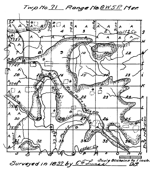
Field Notes of Township No. 71, North of Range 8, West of the Fifth Principal Meridian, Wisconsin Territory, surveyed by E. I. (sic - E. F.) Lucas, commenced August 19, 1837, completed August 31, 1837.
North Between Sect. 35 & 36.
2.56 Hickory 6 in. Diameter.
40.00 Set quarter Sect. post.
Bearings,--
Bur Oak 18 S 64 W 157.
W. Oak 20 N 4 E 875.
50.50 Level timber and enter high rolling prairie.
53.70 Wagon roads to Madison, South E & N W.
62.50 Level prairie and enter small timber & hazel.
79.90 Brook 8 lks wide S of E.
80.00 Set post corner sect. 25, 26, 35 & 36.
Bearings:
Quaking Asp 8 S 10 W 38.
Elm 4 S 29 E 44.
Land 8½ Hilly 2nd rate W Oak, Hickory & N ½ 2nd rate rolling small timber, Blk Jack, Elm, Bur Oak, Hazel,
plumb thorn etc.
East Random between sect. 25 & 36.
5.80 Level timber and enter prairie.
40.00 N. 8 chain is a corn field E & W.
75.60 Enter cornfield N & E chained by Thomas Lambirth a settler on the S E Qr. of Sect. 25.
79.52 Leave fields.
80.34 Intersect Range line 19 lks W of post.
Land first rate prairie, rosin weed, wire grass, etc.
West Corrected between Sect. 25 & 36 Var 9° 15'.
40.17 Set qr. Sect post in mound in prairie--pit 4 lks E.
80.34 Section Corner.
North Between sect. 25 & 26.
1.40 Leave timber and enter prairie.
13.47 Enter cornfields E & W.
Chained by James H. Walker a setler (sic) upon S W qr sec. 25.
24.57 Leave field.
40.00 Set qr. Sect post in mound in prairie Pit S 8° E 30 lks.
80.00 Set post in mound in prairie--Pit 4 lks S 23, 24, 25 & 26.
Land high and rolling, first rate prairie.
Rosin weeds, small grass etc. Some spots of hazel.
August 19, 1837.
East Random between Sect. 24 & 25. Var 9° 15'.
38.00 Leave prairie and enter timber scattering and hazel.
80.18 Intersect Range line 163 lks S of post.
Land W½ high rolling prairie, Rosin weed, small grass & E½ 20 chs barren or Hazel glade last 20 chs Thick
Timber, W. Oak Blk Oak etc.
West Corrected between Sect. 24 & 25 Var 10° 25'.
3.38 W. Oak 18 in dia.
40.24 Set qr. Sect post.
B. Oak 20 N 21½ E 181.
No other tree near of a suitable size.
80.48 Sec. Cor.
North Between Sect. 23 & 24.
40.00 Set qr. Sect post in mound in prairie Pit 4 lks East.
50.34 Brook 6 lks S of E.
Some trees and Hazel grow along the margin of this brook.
80.00 Set post in Mound in prairie. Pit N 70 E 64 lks.
Cor. for sect 13, 14, 23 & 24.
Land rolling 2nd rate a quantity of Hazel, Red Root, etc.
East Random between sect. 13 & 24.
22.00 Leave prairie and enter timber or barrens.
80.40 Intersect range line 74 lks S of post.
Land 2nd rate rolling scattering timber and a great quantity of Hazel, Plumb thorn, Vine, Briers, etc.
West Corrected between Sect. 13 & 24 Var 10° 10'.
8.35 W. Oak 10 in. dia.
17.35 W. Oak 6 in, dia.
40.20 Set qr. sect post.
Bearings:
Hickory 12 S 21½° W 39.
Hickory 6 N 56 E 7.
80.40 Section Cor.
North Between sect. 13 & 14.
26.00 Leave prairie and enter scattering timber.
40.00 Set qr. Sect post.
Black Oak 16 S 25½° E 82.
W. Oak 12 N 44 W 1.36.
80.00 Set post cor. sect. 11, 12, 13 & 14.
Bearings:
W. Oak 22 S 19 E 90.
W. Oak 18 S 40 W 1.22.
Land 2nd rate rolling after leave prairie.
W. Oak, B. Oak, scattering undergrowths, Blk Jack, Hickory, Hazel, Brier, Red root, Vines, etc.
East Random between Sect. 12 & 13.
24.69 Brook 3 lks Wide N of E.
80.20 Intersect range Line 24 lks S of post.
Land 3rd rate rolling or broken. No timber of consequence, more than a few scattering trees -- Hazel Small
Hickory, Oak, Red Root, etc.
West Corrected between Sect. 12 & 13 Var 9° 15'.
40.10 Set qr. Sect post W. Oak 8 N 3½° E 2.95.
No other tree on the opposite of the line of a suitable size.
80.20 Section Corner.
North Between Sect 11 & 12.
7.00 Descend hill to creek.
24.94 Small creek 12 lks east.
27.54 W. Oak 24 in dia.
29.50 Ascend hill.
40.00 Set qr. post.
W. Oak 22 N 24 E 7.82.
W. Oak 20 N 1½ W 11.30.
48.50 Summit of hill there commence short brooks.
74.69 Trail East & West.
80.00 Set post cor. sect. 1, 2, 11 & 12.
W. Oak 80 S 57½ E 72.
W. Oak 18 N 40½ W 101.
Land third rate, S½ rolling, N½ broken, some scattering timber on it, undergrowth, Hazel, Black Oak, R. Oak,
Etc. Along the creek grows Birch, Cottonwood, etc.
East Random between sect 1 & 12 Var 9° 40'.
19.20 Creek 15 lks N.
79.85 Intersect range lne (sic) 42 lks S of post.
Land W½ 3rd rate rolling, E½ gently rolling 2nd rate.
Scattering timber, W Oak, Hazel, Black Oak, Hickory Red Root etc.
West Corrected between Sec. 1 & 12 Var 10° 00'.
15.97 W. Oak 12 in dia.
33.89 W. Oak 10 in dia.
39.92½ Set qr. Sect. post.
Bearings: W. Oak 24 N 49½ E 120.
W. Oak 28 S 7 E 1.57.
42.82 W. Oak 14 in dia.
79.85 Section Cor.
North Between Sec. 1 & 2 Var 8° 30'.
23.40 Descend bluff to creek.
27.05 Creek 18 lks E.
32.40 Bur Oak 8 in. dia.
40.00 Set qr. Sect. post.
Bearings: Bur Oak 10 S 13° E 148.
Bur Oak 8 S 19 W 1.10.
44.00 Ascend high ground.
81.00 Intersect north Boundary of Township 30 lks E of post.
Set post cor. Sec. 1 & 2.
Elm 14 S 54½° E 4.20.
No other tree near south of line of the proper size.
Land S½ 3rd rate hilly W. Oak to the creek, there grows Lynn, Bur Oak, Elm, Birch, Cottonwood, Hazel,
Hickory, Plum Thorn, land 2nd rate, On N½ The opinion of Mr. Parks is not concurred in in (sic) this being prairie.
North Between Sect. 34 & 35. Var 8° 35'.
9.83 Cedar Creek 140 lks wd. N of E bluff banks bold current.
31.53 W Oak 14 in. dia.
40.00 Set qr. Sect. post.
Bearings: W. Oak 24 N 54½ W 78.
W. Oak 20 S 63 E 164.
63.22 W. Oak 12 in. dia.
69.00 Leave timber and outer high dry prairie, rolling.
80.00 Set post in Mound in prairie pit 4 lks South cor. Sect. 26, 27, 34 & 35.
From this stands a house N 24½ E 3.20 lks occupied as a setler (sic) by Owen Callfield, House S 77° W 2.05 lks
no occupant.
Land 3rd rate, Broken W. Oak, Blk Oak Hickory etc. Hazel, Vine etc.
East Random between Sect. 26 & 35.
48.10 Brook 6 lks S of E.
55.35 Waggon (sic) Road N & S.
74.49 Brook 7 lks N of E.
75.00 Leave prairie & enter timber.
79.98 Brook 8 lks S of E.
80.14 Intersect N & S line 10 lks S of post.
Land 1st 75 chs, first rate prairie, rosin weed, short grass etc.
West Corrected between Sect. 26 & 35 Var 9° 20'.
40.07 Set qr. sect. post in mound in prairie Pit 4 lks E.
North of this line 5 chs is a large cornfield claimed by Owen Callfield.
80.14 Sec. Cor.
North Between Sect. 26, 27 Var 9° 35'.
33.46 Enter cornfield West.
Claimed by Amos Lemons, setler (sic) on the S E qr. of 27.
35.70 Leave field.
40.00 Set qr. Sect. post in mound in prairie Pit 4 lks E.
60.96 Waggon (sic) road E & W.
80.00 Set post in mound in prairie pit 4 lks South.
Land first rate, level prairie, fit for cultivation.
Rosin weed, small wire grass.
Cor. sect. 22, 23, 26 & 27.
East Random between sect. 23 & 26 Var 9° 15'.
79.64 Intersect N & S line 32 lks N of post.
Land same as on the North line.
West Corrected between Sect. 23 & 26 Var 9° 00'.
39.82 Set qr. sect. post in mound in prairie Pit 4 lks East.
79.64 Sect. Cor.
North Between Sect. 22 & 23 8° 40'.
40.00 Set qr. Sect. post in mound in prairie pit 4 lks East.
80.00 Set post in mound in prairie pit 4L S cor. sec. 14, 15, 22, 23.
House occupied as a setler (sic) by James Gilmen.
S. 66° E 13.00 lks.
Land is 1st rate. soil Rosin Weed etc. fit for cultivation.
East Random between Sect. 14 & 23 Var 9° 15'.
80.26 Intersect N & S line 34 lks. N of post.
Land first rate soil, but a quantity of Hazel, vines, Hops., etc. covers the greater portion of this line.
West Corrected between sect. 14 & 25 Var 9°.
40.13 Set qr. Sect. post in mound in prairie. Pit 4 lks E.
North 160 lks is a small field N 72° W 5.50 is a house now building by William Daugherty.
80.20 Section Cor.
North Between Sect. 14 & 15 Var 8° 30'.
4.70 Leave prairie and enter timber.
7.00 Hickory 10 in. dia.
13.61 Hickory 14 in. dia.
40.00 Set qr. Sect post.
W. Oak 20 N 49½ W 63.
Br. Oak 8 N 3 W 1.57.
52.40 Brook 3 lks N E.
72.72 Brook 4 lks East.
78.04 W. Oak 22 in. dia.
79.00 Enter small cr. bottom.
80.00 Set post cor. Sect, 10, 11, 14 & 15.
Cottonwood 12 S 35° E 58.
Birch 15 S 75½ W 119.
Land S½ 2nd rate thinly timbered. W. Oak, Hickory, Hazel, Briers, North½ (sic) 3rd rate unfit for cultivation,
timber same.
East Random between Sect. 11 & 14 Var 9° 15'.
00.55 Small creek 8 lks S of East.
3.50 Leave bottom and ascend high land.
18.00 Descend bluff to creek.
19.00 Enter bottom.
20.40 Creek 15 lks North.
26.80 Ascend high land.
79.90 Intersect N & S line 24 lks N of Post.
Land rolling 3rd rate and but a few Scattering trees W. Oak, Hazel B. Oak, Grubs, etc.
West Corrected between Sect. 11 & 14 Var 9° 05'.
39.95 Set qr. sect. post.
W. Oak 20 S 7½ E 17.
W. Oak 24 N 13 W 54.
79.90 Sect. Cor.
August 22, 1837.
North Between Sect. 10 & 11 Var 8° 30'.
00.90 Small Creek 8 lks E.
21.00 Enter small prairie.
30.94 Brook 5 lks East.
40.00 Set qr. Sect post.
W. Oak 6 S 82½ W 14.
W. Oak 12 N 4° E 8.53.
47.50 Leave prairie and enter timber.
50.65 W. Oak 16 inches diameter.
55.87 Train E and W. (Trail?)
80.00 Set post Cor. Sect. 2, 3, 10 & 11.
Hickory 6 N 83° W 4.30.
Bur Oak 12N 19 E 288.
Land 2nd rate rolling, W. Oak, Bur Oak, Hazel, Red Root Tall grass. The prairie mentioned here cannot hardly
said to be called prairie.
East Random between 2 & 11 Var 9° 15'.
80.40 Intersect N & S line 49 lks N of post.
Land 3rd rate, broken W½ but little timber. W. Oak, Hazel, Hickory Grubs.
West Corrected between Sect. 2 & 11 Var 8° 55'.
4.48 W. Oak 22 in. dia.
6.19 W. Oak 22 in. dia.
40.20 Set qr. sect. post
W Oak 13 N 7½° E 138.
W. Oak 10 S 73 E 158.
80.40 Sect. Cor.
North Between Sect. 2 & 3 Var 8° 35'.
16.03 Creek 15 lks E.
25.17 Bur Oak 24 in. diam.
26.00 Ascend high land.
40.00 Set qr. sect. post.
Hickory 12 N 25½ E 2.73.
Hickory 14 N 70 W 4.62.
57.67 Hickory 18 in. diameter.
80.94 Intersect North boundary of Township 60 lks E of post.
Set post cor. Sect. 2 & 3.
Elm 18 S 12 W 251.
Hickory 12 S 74 E 439.
Land 2nd rate gently rolling. W. Oak, Bur Oak, Hickory, Elm undergrowth Hazel, Plumb thorn Briers, Vines, etc.
I am sorry that I cannot call this prairie.
North Between Sect. 33 & 34 Var 9° 10'.
4.95 Bur Oak 7 in. diam.
11.40 Ascend bluff from Cr. Bottom.
14.80 Commences highrolling land.
16.72 W. Oak 14 in. diam.
23.89 W. Oak 20 in diam.
38.90 Red Oak 18 in. diam.
40.00 Set qr. Sect. post.
W. Oak 11 N 33½ W 13.
W. Oak 14 E 49 lks.
47.49 Red Oak 22 in. diam.
56.48 W. Oak 14 in. diam.
80.00 Set post Cor. sect. 27, 28, 33 & 34.
Bearings:
W. Oak 10 N 68½° W 12.
W. Oak 10 N 8° E 13.
Land first 11 ch 1st rate, Lynn, Bur, Oak, Elm, & Nettels. Last 69 chs 2nd rate rolling W. Oak Hickory, Plumb,
Iron weed, etc.
East Random between Sect. 27 & 34 Var 9° 10'.
56.40 Leave timber and enter high level prairie.
81.05 Intersect North & South line 96 lks North opposite.
Land first 55 chs broken 3rd rate W. Oak, B. Oak, Hickory, Hazel, etc. Last 25 chs first rate prairie. Rosin
weed, Milk weed, etc.
West Corrected between Sect. 27 & 34 V 8° 30'.
35.38 Hickory 8 in. diam.
40.57½ Set qr. Sect post.
Bearings: W. Oak 22 S 32½ W 37.
Hickory 7 N 55 E 53.
59.09 W. Oak 13 in. diam.
70.06 Bur Oak 18 in. diam.
81.05 Sect. Cor.
North Between Sect. 27 & 28 V 9° 10'.
2.15 W. Oak 6 in. diam.
13.83 Bur Oak 6 in. diam.
15.85 Waggon (sic) Road S W & N E.
House N 67° about 13 chs occupied a setler (sic) by Isaac Blaker.
32.25 Brook 3 lks wide W.
40.00 Set qr. sect. post.
Bearings: Hickory 11 N 20½ W 87.
Elm 14 N 8 E 164.
47.58 Pin O. 15 in. diameter.
52.86 Pin O. 6 in. diameter.
64.19 Leave timber and enter prairie.
72.26 Enter cornfield.
80.00 Set post in mound in cornfield cor. sect. 21, 22, 27 & 28. Cornfield claimed John N. Gillam Setler, whose house
stands S 34 W 9 ch.
Land to the prairie 2nd rate. Hickory, Elm, Pin Oak, Hazel.
East Random between Sect. 22 & 27 Var 9° 00'.
14.59 Leave field.
46.72 Waggon (sic) road T E (sic - S E?) & N W.
S of the 25 ch. is a large cornfield.
81.26 Intersect N & S line 14 lks N of post.
Land first rate prairie, Rosin weed, wire grass etc.
West Corrected between sect. 22 & 27 Var 8° 55'.
40.63 Set qr. sect. post in mound in prairie.
81.26 Sect. Cor.
North Between Sect. 21 & 22 Var 9° 10'.
7.49 Leave field.
40.00 Set qr. sect. post in mound in prairie pit 4 lks East.
60.29 Waggon road S E & N W.
80.00 Set post in mound in prairie Cor. for sect 15 16 21 & 22 Pit 4 lks S of post.
Land first rate level prairie. Rosin weed small wire grass etc.
East Random between Sect. 15 & 22 Var 9° 00'.
41.00 Leave prairie and enter timber.
54.00 Leave timber and enter prairie.
81.14 Intersect North and South line 50 lks N of Post.
Land 2nd rate rolling, prairie. Large quantity of Hazel, Red Root etc.
West Corrected sect. 15 & 22 Var 8° 40'.
40.57 Set qr. sect. post in mound in prairie Pit 4 lks E.
81.14 Sect. corner.
August 24, 1837.
North Between Sect. 15 & 16 Var 9° 10'.
40.00 Set qr. sect. post.
Bearings: W. Oak 24 N 63° E 3.64.
Hickory 10 N 11° W 6.13.
45.00 Leave prairie and enter timber.
57.48 Blk Oak, 18 in. diam.
80.00 Set post cor sect. 9, 10, 15 & 16.
Bearings: Hickory 10 N 64½ W 82.
W. Oak 24 S 54 E 72.
Land 2nd rate rolling, some hazel, on prairie.
Timber Hickory, W. Oak, R. Oak B. Oak, Plumb thorn, Vines, Hazel, etc.
East Random between sect. 10 & 15 Var 8° 50'.
20.53 Brook 3 lks North.
39.45 Brook 3 lks North.
81.17 Intersect N & S line 22 lks S of post.
Land W½ gently rolling 2nd rate, fit for cultivation.
Hickory, W. Oak, Hazel, etc. E½ 3rd rate hilly, Thinly timbered unfit for cultivation, W. Oak, Hazel, briers,
Red Root etc.
West Corrected sect. 10 & 15 Var 9° 00'.
40.58 Set qr. Sect. post.
Bearings: W. Oak 24 S 36½° E 54.
W. Oak 11 N 10 W 37.
41.83 W. Oak 16 in diam.
60.31 Hickory 6 in diam.
81.17 Section Cor.
North Between Sect. 9 & 10 Var 9° 10'.
4.64 Blk Oak 14 in diam.
15.87 Brook 4 lks Wide East.
27.35 W. Oak 15 in. diam.
40.00 Set qr. sect. post.
Bearings: Hickory 8 N 88° W 37.
B. Oak 16 S 69½ E 71.
44.00 Leave timber and enter prairie or barrens with a few scattering trees.
55.97 Trail E & W.
80.00 Set post in mound in prairie or barrens corner Sect. 3, 4 9 & 10 Pit 4 lks South.
Land 2nd rate gently rolling, fit for cultivation.
Tall grass after leave timber, same as last N mile.
East Random between Sect. 3 & 10 Var 9° 15'.
81.64 Intersect N & S.
Line 14 lks N of post.
Land 3rd rate hilly unfit for cultivation. A few scattering trees, undergrowth Blk Oak, W. Oak, Red Root,
Hickory, Willow & a growth of yellow moss cover the surface.
West Corrected between Sect. 3 & 10 Var 9° 10'.
40.82 Set qr. sect. post.
W. Oak 26 S 5½ E 3.59.
Bur Oak 16 N 80½ W 3.32.
81.64 Sect. Cor.
North Between Sect. 3 & 4 Var 9° 10'.
23.40 Descend bluff to creek.
25.53 Creek 12 lks wide E.
26.33 Bur Oak 14 in. diam.
40.00 Set qr. sect. post.
Bur Oak 8 S 89½ E 1.87.
Bur Oak 16 N 6½ W 3.47.
51.75 Bur Oak 18 in. diam.
79.56 Intersect N Boundary in Township of 81 lks E of post, set post cor. for sect. 3 & 4.
Elm 12 S 74 E 3.38.
Hickory 8 S 52 W 546.
Land south of creek 3rd rate, thence to the north Boundary first rate, Bur Oak, Elm, Lynn, Hickory & Hazel,
Tall grass from the Creek growth usual.
Aug. 25 1837.
North Between Sect. 32 & 33.
5.00 W. Oak 36 in. diam.
14.97 W. Oak 8 in diam.
40.00 Set qr. Sect. post.
Bur Oak 12 N 62½ W 135.
Bur Oak 10 S 59 E 53.
55.98 W. Oak 12 in. diam.
80.00 Set post cor. Sect. 28, 29 32 & 33.
W. Oak 18 N 34 E 53.
W. Oak 20 S 29½ W 40.
Land 2nd rate rolling W Oak R Oak, Bur Oak Hickory, Elm etc. Hazel Briers Vine etc.
East Random between Sect. 28 & 33 Var 9°.
5.95 Rock Creek 70 lks S W.
High bluff banks, dull current, rock bottom.
25.30 Brook 6 lks South.
70.69 Waggon road N & S.
81.12 Intersect North & S line 11 lks North of Post.
Land 2nd rate W½ hilly, E½ gently rolling W Oak Hickory, E. Oak etc. (sic - B. Oak?)
West Corrected between Sect. 28 & 33 Var 9° 55'.
3.89 Hickory 8 in. diam.
10.61 W. Oak 20 in. diam.
40.56 Set qr. Sect. post
W Oak 12 S 33 E 39.
W. Oak 24 N 66½ W 42.
48.30 W. Oak 10 in diam.
52.32 W. Oak 12 in diam.
81.12 Sect. Cor.
North Between Sect. 28 & 27.
5.44 Rock Creek 15 lks East.
13.31 Hickory 6 in. diam.
40.00 Set qr. Sect. post.
W. Oak 30 S 60 W 13.
Hickory 8 N 74½ E 40.
54.40 W. Oak 12 in diam.
56.76 W. Oak 8 in diam.
64.85 W. Oak 12 in diam.
80.00 Set post cor. Sect. 20, 21 29 & 28.
W. Oak 20 N 60½ E 39.
W. Oak 12 S 86 W 13
Land S½ 3rd rate thinly timbered. W. Oak undergrowth, Hazel Oak, etc.
N½ 2nd rate, gently rolling, W. Oak, Blk Oak, R. Oak Hickory.
East Random between Sect. 21 & 28 Var 9° 00'.
42.00 Leave timber and enter prairie.
79.32 Enter field.
81.09 Intersect N & S line 30 lks of post.
Land first ½ rate thinly timbered, E½ prairie 1st rate.
West Corrected between Sect. 21 & 28 Var 8° 50'.
40.54½ Set qr. Sect. post.
Hickory 18 S 61½ W 77.
Hickory 10 N 11 E 2.60.
81.09 Sect. Cor.
North Between Sect. 20 & 21 Var 10° 00'.
5.92 R. Oak 10 in. dia.
25.96 W. Oak 12 in. diam.
2942 Brook 4 lks Wide West. (no decimal in measurement)
32.90 W. Oak 30 in diameter.
40.00 Set qr. Section post.
W. Oak 14 S 39 E 18.
W. Oak 10 N 50½ W 68.
44.95 W. Oak 13 in. diameter.
47.85 Brook 4 lks wide West.
59.97 W. Oak 17 inches diameter.
71.93 Bur Oak 10 in diameter.
80.00 Set post corner for Sect. 16, 17, 20 & 21.
Bur Oak 10 N 8½ E 37.
Hickory 12 S 46½ W 20.
Land 2nd rate, rolling, W. Oak, B. Oak, R. Oak, Hickory, etc.
August 26, 1837.
East Random between Sect. 16 & 21 Variation 9°.
18.00 Leave timber and enter prairie.
63.75 Enter cornfield owned by Samuel Walker a setler (sic) on the N W quarter of Sect. 21. (At 53.75?)
54.91 Leave field.
63.35 Waggon road to Madison SE & N W.
81.40 Intersect North & South line 69 lks S of post.
Land 1st 18 chs. 2nd rate, Hickory, W. Oak, Red Oak, & Hazel. Last 62 chs first rate, prairie, fit for
cultivation, Rosin and wire grass etc.
Alexander Kirk is setler on the S E qr. of Sect 16.
West Corrected between Sect. 16 & 21 Var 9° 30'.
40.70 Set qr. Sect. Post in mound in prairie Pit 4 lks E.
81.40 Section Corner.
North Between Sect. 16 & 17 Var 10°.
4.96 Brook 4 lks Wide W.
10.36 Hickory 8 in dia.
27.00 Leave timber and enter prairie.
31.00 West 3 ch. & 40 lks stands house reported to be owned by Thomas Johnson who is absent.
32.03 Enter field N & E.
40.00 Set qr. sect. post in mound in cornfield Pit 4 lks E.
40.38 Leave field.
68.40 Waggon road to Madison S E & N W.
70.35 Enter cornfield E & W owned by Richard Steward a setler on the S E pr. of Sect. 18.
80.00 Set post in mound in corner pit 4 lks S Cor. sect 8, 9, 16 & 17.
Land 8½ (sic - S½?) 2nd rate, N½ 1st rate.
East Random between Sect 9 & 16 Var 9° 25'.
3.71 Leave cornfield.
67.50 Leave praire and enter Scattering timber.
81.00 Intersect N & S line at post.
Land rolling first rate to the timber, thence 2nd rate.
Hickory B. Oak, R. Oak Haze, etc.
West Corrected Sect. 9 & 16.
40.52 Set qr. Sect post in mound in prairie. Pit 4 lks East.
81.04 Section corner.
North Between Sect. 8 & 9 Var 10°.
2.47 Leave field.
40.00 Set qr. Sect. post in prairie or hazel brush, Pit 4 lks East.
65.00 Leave prairie and enter scattering timber.
68.73 W. Oak 14 in dia.
80.00 Set post cor. sect. 4, 5, 8, & 9.
W. Oak 10 S 75 E 40.
W. Oak 18 N 15 E 1.27.
Land 2nd rate rolling, the prairie post here set forth rough. Hazel, Plum, Thorns, Vine, Briers, B. Oak W. Oak.
Grubs Last 15 chs. 3rd rate W. Oak, Hazel, etc.
East Random between Sect. 4 & 9 9° 35'.
39.00 Leave Scattering timber and enter prairie.
81.02 Intersect N & S 38 lks S of post.
Land 3rd rate Rolling W½ a few W & B Oak trees. E½ Barron or rough prairie.
West Corrected between Sect. 4 & 9 Var 9° 50'.
40.51 Set qr. sect. post in mound in prairie.
Pit 4 lks East.
81.02 Section corner.
North Between sect 4 & 5 Var 10°.
4.50 Descend hill to creek.
5.63 W. Oak 18 in diameter.
12.75 Enter bottom
14.30 Creek 8 lks wide E.
38.72 Elm 10 in diameter.
40.00 Set qr. sect. post.
Ironwood 10 S 33 W 25.
Elm 8 N 81 E 10.
41.66 Hickory 14 in diameter.
79.82 Intersect North Boundary of Township 63 lks.
Pin Oak 8 S 25 W 2.69.
Pin Oak 10 S 54 E 1.95.
Land S of creek 3rd rate level.
N of creek, gently rolling first, Elm, Lynn, Pin Oak I. Oak Ironwood, Hazel, Plum, Thorn Vine etc.
Rhodeham Bonnafield a setler on the N W of the S W qr. of sect. 4.
August 28, 1837.
North Between sect. 31 & 32 Var 10° 25'.
4.50 Leave timber and enter prairie.
38.50 Leave prairie and enter timber.
40.00 Set qr. Sect. post.
W. Oak 6 N 11 E 45.
W. Oak 9 S 53 W 19.
44.50 Descend hill to creek.
45.23 Cedar bluff bank, dull current.
48.53 B. Walnut 10 in diam.
50.50 Leave bottom and rise high rolling land.
66.74 Bur Oak 8 in diam.
80.00 Set post cor. sect 29, 30, 31 & 32.
B. Oak 14 S 76 W 20.
B. Oak 10 N 53 E 53.
Land 2nd rate Bur Oak B. Oak Hickory, etc.
East Random between Sect. 29 & 32 V 9° 10'.
80.38 Intersect N & S line 27 lks S of post.
Land 2nd rate gently rolling, W. R & B Oak Hickory, Hazel Red Root, etc.
West Corrected between Sect. 2 & 9 Var 9° 20'.
7.29 W. Oak 7 in diam.
24.68 W. Oak 20 in diam.
33.08 Hickory 8 in diam.
40.19 Set qr. Sect post.
W. Oak 18 S 69 W 9.
Br. Oak 4 N 22 W 22.
61.13 W. Oak 22 in diam.
80.38 Sect. Corner.
West Random between 30 & 31 Var 9° 20'.
15.27 Brooks 3 lks wide S.
24.37 Waggon road N & S.
78.77 Intersect W. Bdy of Township 22 lks S of post toaks bearings, (sic)
Marked corner Sect. 30 & 31.
I. Oak 8 N 69 E 1.80.
Hickory 12 S 36 E 2.01.
Land 2nd rate E½ Rolling, W Oak B. Oak, Hickory, W½ level thinly timbered what is now proper for an Oak
opening.
East Corrected between Sect. 30 & 31.
38.77 Set qr. post.
Hickory 6 N 21 W 9.
W. Oak 15 S 27 W 47.
On the S W quarter of the N E qr. of Sect 31 is a Mile site (sic) and a mile in an advanced stage of bldg.
The name of the occupant or owner of mile not known.
56.09 B. Oak 14 in. diam.
57.22 W. Oak 20 in. diam.
78.77 Section corner.
North Between Sect. 29 & 30 Var 10° 25'.
5.11 Blk Oak 11 in diam.
18.99 W. Oak 18 in diam.
24.97 Hickory 20 in diam.
40.00 Set qr. sect post.
W. Oak 24 S 77 W 77.
Hickory 4 N 86 E 16.
56.03 B. Oak 8 in diam.
57.65 W. Oak 12 in diam.
60.43 Waggon road north east & S W.
73.32 Rock Creek 15 lks wide E.
75.00 Leave timber and enter prairie.
80.00 Set post in prairie in mound pit 4 lks South Cor. sect. 19, 20, 29 & 30.
W. Oak, B. Oak, Hickory, Land 2nd rate, gently rolling.
East Random between sect. 20 & 29 Var 9° 15'.
7.69 Waggon road N & S.
46.50 Leave prairie and enter timber.
58.69 Brook 8 lks wide S.
80.33 Intersect N & S line 22 lks S of post.
Land W½ rolling 2nd rate E½ hilly 3rd rate, W. Oak R. Oak, Hickory etc.
West Random between Sect. 18 & 19 Var 9° 25'.
77.48 Intersect W Boundary of T. 12 lks N. of post. Marked No's for sect. 18 & 19.
Cornfield S 32° E on the N W qr. of sect. 19 claimed by Samuel S. Walker.
Land first rate, Rosin weed, wire grass etc.
East Corrected sect. 18 & 19 Var 9° 30'.
37.48 Set qr. Sect. post in mound in prairie pit 4 lks E.
77.48 Sect. Corner.
North Between Sect. 17 & 18 Var 10° 25'.
24.11 Brook 4 lks E.
40.00 Set qr. sect post in mound in prairie pit 4 lks E.
Joseph Parker a setler S E qr of 17.
80.00 Set post in mound in prairie pit 4 lks South.
Cor. for sect. 7 8 17 & 18.
Land first rate rolling prairie with some Hazel on it, Rosin weed, Red Root, small wire grass etc.
East Random between Sect. 8 & 17 Var 9° 35'.
3.00 Cornfield claimed by Alfred Right a setler on the S W qr of sec. 8.
30.10 Leave field.
54.80 Wagon road.
64.14 Enter field.
80.39 Intersect N & S line 13 lks N of post in Cornfield.
Land first rate level, prairie fit for cultivation.
Rosin weed & some small Hazel etc.
West Corrected between Sect. 8 & 17 Var 9 30.
40.19½ Set qr. Sect post in mound in prairie pit 4 lks E.
80.39 Sect. Cor.
West Random between Sect. 7 & 18 Var 9° 30'.
77.47 Intersect W. Boundary of Township 9 lks South of post.
William Barger a setler on the S E qr. Sect 7.
James Lanman a setler on the S W quarter of Sect. 7.
Land first rate prairie, Rosin weed some Hazel etc.
East Corrected between Sect. 7 & 18 Var 9° 25'.
37.47 Set qr. Sect post in mound in prairie pit 4 lks E.
77.47 Sect. Corner.
August 30, 1837.
North Between Sect. 7 & 8 Var 10° 25'.
2.80 Waggon road E & W.
13.50 Leave prairie and enter timber.
16.34 B. Oak 22 in diameter.
24.30 B. Oak 20 in diam.
40.00 Set qr. sect. post.
W. Oak 22 S 30½ W 14.
W. Oak 18 N 46 E 98.
42.31 Blk Oak 14 in diam.
46.81 W. Oak 16 in diam.
64.03 R. Oak 13 in diam.
67.14 Sanman's Run 8 lks.
80.00 Set post cor. sect. 5, 6, 7 & 8.
Hickory 10 S 27 W 16.
Red Oak 24 S 64½ E 62.
Land 2nd rate, rolling W. Oak, B. Oak Hickory, along the new grows Lynn Birch Elm etc. Hazel, Birch Vine,
Elm etc., Hazel Briers Vine tall weeds.
West Corrected Sect. 20 & 29 Var 9° 25'.
1.58 W. Oak 10 in diam.
40.16½ Set qr. Sect post.
R. Oak 8 S 85½ E 6.33.
Hickory 10 N 47 E 5.25.
80.33 Sect. Cor.
West Random between Sect. 19 & 30 Var 9° 25'.
9.00 Leave prairie & enter timber.
11.74 Creek 80 lks wide S E.
13.74 Creek 10 lks wide North.
14.36 Creek 15 lks wide Do S. (sic)
78.13 Intersect W Boundary of Township 9 lks N of Post. Cor for Sect. 19 30.
Bur Oak 8 N 61 E 60.
W. Oak 15 S 35 E 62.
Land 2nd rate rolling W. Oak B Oak R Oak Hickory, undergrowth Hazel Brier vines Red Root etc.
East Corrected between Sect. 19 & 30 Var 9° 30'.
5.43 W. Oak 4 in diam.
12.83 W. Oak 12 in do.
15.39 W. Oak 30 in diam.
38.15 Set qr. sect. post.
B. Oak 8 S 42 W 11.
W. Oak 6 N 68½ W 15.
38.37 R. Oak 6 in diam.
78.13 Section Corner.
From this to the prairie thinly timbered, Hazel, Brush thick & tall.
August 29, 1837.
North Between Sect. 19 & 20 Var 10° 25'.
40.00 Set qr. Sect. post in mound in prairie 4 lks East.
51.14 Enter large cornfield E & W Owned and claimed by William I Stout and Hasey I Stout, setlers but no house
holders.
67.30 Leave field.
80.00 Set post in Mound in prairie Pit 68° E 53 lks.
Cor. Sect. 17, 18 19 & 20.
Land S½ 2nd rate Small Hazel, R. Root, Rosin weed. N½ First rate, rolling, Rosin weed, wire grass.
East Random between sect. 17 & 20 Var 9° 20'.
36.00 Leave prairie and enter timber.
43.28 Waggon road N & S.
73.32 Wigwam. (At 72.32?)
73.16 Brook 8 lks S.
75.16 Brook 8 lks S.
80.13 Intersect N & S line ce lk N of post (sic).
Land first rate W½ prairie Hazel, R. Root etc. E½ Hickory, Bur Oak W. Oak, Elm along the Brook grows Birch,
Lynn, etc.
West Corrected and blazed a back V. not altered.
5.43 Birch 12 in diam.
9.12 Elm 10 in diam.
30.00 S. 8° E 475 lks is a house occupied by Geo Stout.
40.06 Set qr. Sect post.
Br. Oak 20 S 26 W 58.
Hickory 7 N 72 E 37.
80.13 Section Corner.
East Random between Sect. 5 & 8 Var 9 25.
25.68 Lanemans Run 24 lks N of E.
80.43 Intersect north & South line 100 lks N of post.
Land W ½ 2nd rate rolling, hickory, Burr & W Oak.
Lynn etc. E ½ 3rd rate, hilly thinly timbered unfit for cultivation. Hazel Briers Vine etc.
West Corrected between sect 5 & 8 Var 8 45.
40.21½ Set qr. sect post.
W. Oak 12 S 54 W 2.14.
W. Oak 10 N 53 W 1.29.
46.05 W. Oak 22 in diam.
48.53 W. Oak 11 in diam.
80.43 Section Corner.
West Random between Sect. 6 & 7 Var 9° 35'.
67.55 Brook 8 lks S E.
77.83 Intersect W. Boundary Township 2 lks S of post.
Cor sect. 6 & 7.
Land E ½ 2nd rate rolling. Hickory, W & R Oak, Bur Oak W ½ first rate, level, Elm, Lynn, Walnut, etc.
James Clark a setler on the S W Quarter of Sec. 6.
East Corrected and blazed back on true line V. same.
Elm 26 S 77 E 11.60.
B. Walnut 20 N 89 E 9.20.
25.10 Hickory 12 in diam.
32.22 Waggon road N & S.
37.83 Set qr. Sect. post.
I Oak 4 N 57 W 11.
I Oak 6 S 32 E 30.
60.26 Hickory 12 in diam.
67.37 Bur Oak 8 in diam.
77.83 Section Corner.
North Between Sect. 5 & 6 Var 9 25'.
40.00 Set qr. Sect. post.
I Oak 6 S 73 E 104.
I Oak 7 N 5 W 2.45.
43.00 Leave scattering timber and enter open prairie or Barren.
53.63 Brook 3 lks East.
77.48 Intersect North Boundary Township 63 lks W of post.
Set post cor. sect. 5 & 6.
I Oak 10 S 76° E. 5.21.
No other tree near enough.
Land 2nd rate to the prairie. I Oak, Hickory, W. Oak, etc. The prairie first rate, some Hazel, Plum, Red Root.
August 31st, 1837.
I hereby certify that in pursuance of a contract with Surveyor General, Robert T. Lytle, of the United States for the United States of Ohio, Indiana and Michigan and Territory of Wisconsin bearing date the 23rd day of May, 1837 and in strict conformity to the laws of the United States and the instructions of said Surveyor General I have surveyed and subdivided into Sections Township No. 71 in Range No. 8 West of the 5th Principal Meridian, in the Territory of Wisconsin and I do further certify that the foregoing are the true and original Field Notes of Said Survey and subdivision executed as aforesaid.
Certified this 31st day of August, 1837.
E. F. Lucas, Dep. Surveyor.
W. H. Cook,
Jacobsen Purjue, Chairman.
Reuben W. Dodd, Marker.
By way of a general description it may be said of this Township that it comprises a great variety of soil as well as many other good qualities together with the disadvantages that are incident to it. The prairie portion is well adapted to cultivation and a considerable portion of the timbered part.
The N. E. Corner of the Township, the soil is of a third rate quality. The timber is thin; but the Hazel and the small growth around the margin of the prairie is in abundance. In regard to water privileges, Cedar Creek passes through the S Boundary which afords (sic) a sufficiency of water previleges (sic) for all manner of machinery that may be necessary for a country frought with so many good qualities as this is. There is an abundance of good building stone in various places, together with large quantities of stonecoal which has been discovered in passing through the township.
Return to the 1912 History of Jefferson County Contents Page