 |
The Land Survey |
 |
|
|
The Land Survey |
|
The first settlers came to an open country where each as he arrived selected a place that pleased his fancy. If his tract adjoined the claim of another, it conformed to that. Beyond this there was no regularity of bounds and no certainty of acreage. There could be none until the lands were surveyed and points and lines established. No title could be acquired until this was done. In the meantime the settlers were but "squatters" whose rights of possession were acknowledged and protected under rules imposed and enforced by themselves.
A moment's reflection will suggest the importance of the governmental survey in permanent settlement and development. It underlies the ownership of land by fixing its exact location. Upon its divisions rests largely the machinery of local government.
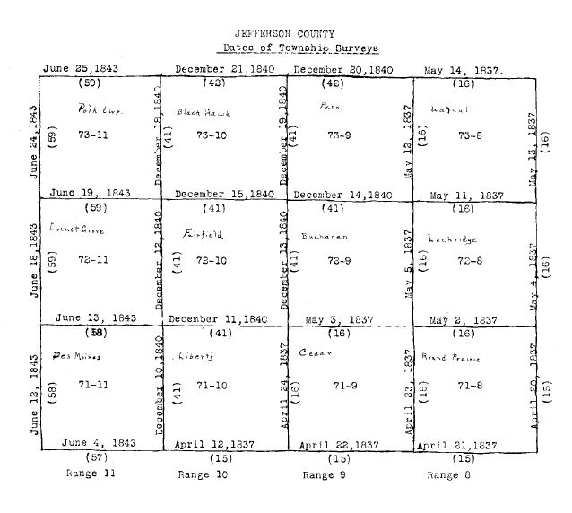
The survey of Jefferson County, as of the larger part of Iowa, proceeds westwardly from the fifth principal meridian, a line extending due north from the mouth of the Arkansas River, and northwardly from a line extending due west from the mouth of the St. Francis River in Arkansas. Parallel to these two lines are run others at regular intervals of six miles. Those running east and west are known as township lines and beginning with the base line are numbered consecutively to the north. Those running north and south are known as range lines and beginning with the fifth principal meridian are numbered consecutively to the west. In this symmetrical arrangement of squares the lands enclosed between the intersecting lines make townships. The first square formed in the process is township number one north, range one west; the square north of it is township number two north, range one west; the square west of it is township number one north, range two west; and the square which corners with it is township number two north, range two west. The specific description of a township is the numbers of its base and range lines and their directions.
On April 12, 1837, was run under governmental authority the first township line related to Jefferson County. It was number seventy-one north for range ten west and lies between the present Township of Liberty and the County of Van Buren. It was established by Hervey Parke, a deputy surveyor, under a contracted dated October 1, 1836, covering the states of Ohio and Indiana and the Territory of Michigan, which then included Iowa. More than six years were to pass before the township survey of the county was completed. The last township line run was number seventy-four north for range eleven west. It separates the present Township of Polk from Keokuk County. It was established on June 25, 1843, by Alvin Burt, a deputy surveyor, under a contract dated May 8th in the same year.
In 1837 four townships of the county were defined. They were then in Henry County. The surveyor was Hervey Parke. It was the rule to run and to mark a line in one day. The first township to have its boundaries determined was number seventy-one north, range eight west. This is Round Prairie. On April 20th its eastern line was established; on April 21st, its southern line; On April 23rd, its western line; on May 2d, its northern line. Townships number seventy-one north, range nine west, and numbers seventy-two and seventy-three north, range eight west, followed in quick succession. On May 14th, line number seventy-four north for range eight west was run completing this survey. These townships are respectively Cedar, Lockridge and Walnut. They were in the Blackhawk Purchase, and between them and the Indian Boundary remained only fractional townships.
In December, 1840, five additional townships were defined. The surveyor was Uriah Biggs. These were number seventy-one north, range ten west, and numbers seventy-two and seventy-three north, ranges nine and ten west. These were in part from the Blackhawk Purchase and in part from the Second Purchase. They are respectively Liberty, Buchanan, Center including Fairfield, Penn and Blackhawk.
In June, 1843, the remaining townships were defined. The surveyor was Alvin Burt. These were numbers seventy-one, seventy-two and seventy-three north, range eleven west. A little more than half their lands came from the Second Purchase, the remainder from the New Purchase. These townships are respectively Des Moines, Locust Grove and Polk.
After the boundaries of a township are established, there is made a sectional survey. This divides it in thirty-six blocks each a mile square. These blocks are called sections and are regularly numbered, beginning with the one in the northeast corner, proceeding consecutively to the range line on the west, then back and forth alternately and ending with the one in the southeast corner.
A section contains 640 acres. It is divided into halves of 320 acres by a north and south line, and into quarters of 160 acres by an east and west line. A quarter section is subdivided by similar lines into halves and quarters. The Goverment's surveyor's (sic) ran only the section lines, but they marked on these the terminal points of the lines making the halves and quarters.
The sectional survey starts on the township line at the corner of Sections 35 and 36. From this point the section line is run north and parallel to the range line a distance of eighty chains, one mile. This gives the section corner, from which a line at right angles to the section line is run eastward to the range line. This is technically termed the "random." The direction and distance of the intersection of the random and range lines from the post marking the section corner is noted. The true line is then run from the section corner westward to the starting point. The lines of the sections to the north are found in the same manner until the township line is reached and intersected. Beginning again at the base or township line on the south with the next section corner to the west, a second row of sections is defined. This process is repeated until in running the fifth section line north randoms and true lines are also run to and from the range line on the west. The intersection of this fifth section line with the township line on the north completes this survey.
The sectional survey of the lands of Jefferson County began in the fall of 1837 in Township No. 71 north, range nine west. Townships Nos. 71, 72 and 73 north, range eight west, were next surveyed in the order named. The surveyor was E. F. Lucas, who accomplished the work in little more than three months.
In the spring and summer of 1841, five townships were surveyed. These were Townships Nos. 73 north, ranges nine and ten west, the surveyor of which was Samuel C. Wiltse, and Townships Nos. 71 and 72 north, range ten west, and No. 72 north, range nine west, the surveyor of which was James E. Freeman.
In the fall of 1843 the last three townships were surveyed. These were Township No. 71 north, range eleven west, the surveyor of which was W. Barrows, and Townships Nos. 72 and 73 north, range eleven west, the surveyor of which was Alvin Burt. It seems the work of Barrows was not properly performed, for Township No. 71 north, range eleven west, was resurveyed in June, 1846, by Paul C. Jeffries.
These surveyors made ample field notes which present a succinct description of the country. The prairie and timber, the varieties of shrubs and trees, the character of the soil, cultivated fields, houses, trails, roads, streams, mill-seats, coal and stone, are all accurately noted. Distances are given in chains and links. Many abbreviations are used and to read their records easily these should be made familiar. The more important are sec. for section, qr. for quarter, cor. for corner, intd. for intersected, dia. for diameter, and var. for variation. The points of the compass are indicated by the letter N for north, S for south, E for east, and W for west. Initials of words which may be completed from the context are quite common, as W. for white, B. for black, R. for red, J. for jack, U. G. for undergrowth, and L. for links. These field notes are of sufficient interest and importance to be set out in full for the sales of these lands by the Government were based upon these surveys.
1. Each township line was surveyed on date as given.
2. The numbers enclosed in parentheses are the numbers of the books in which field notes of surveys are found, and are books numbered 15, 16, 41, 42, 57, 58 and 59.
3. The items or data given below, by books, refer to all the lines included in the respective books, as shown by the numbers on the township lines of the plat.
Book No. 15. Contract dated October 1, 1836, covering the states of Ohio and Indiana and Territory of Michigan (which then included what is now Iowa); book certified to June 14, 1837, by Hervey Parke, D. S., and signed also by M. B. Smith, title not given but probably one of the chainmen.
Book No. 16. Contract same as above, certified same date, and signed Hervey Parke, D. Surveyor, and by M. B. Smith.
Book No. 41. Contract dated October 16, 1840, covering territories of Wisconsin and Iowa; book certified December 20, 1840, by Uriah Biggs, Dep. Sur., also as follows: Hugh George, Aaron D. Hurley, chainmen; Ira Claflin, marker.
Book No. 42. Contract same as above; certified December 30, 1840; by Uriah Biggs, Dep. Sur., and also signed same as No. 41 by chainmen and marker.
Book No. 57. Contract dated May 8, 1843; book certified June 16, 1843, by Alvin Burt, Dep. Sur., and signed also as follows: John S. Byrnes, Elijah Eaton, Isaac H. Vanderburgh, Alvin Fairbrother. Titles not given; probably chainmen and markers.
Book No. 58. Contract same as No. 57; certified same date, and signed by same persons.
Book No. 59. Contract same as No. 57; certified July 31, 1843, and signed by same persons as No. 57 and 58.
Return to the 1912 History of Jefferson County Contents Page