METES AND BOUNDS.
 UP to the
time of the Revolutionary War, or until about the beginning of the present
century, land. when parceled out, and sold or granted, was described by
"Metes and Bounds," and that system is still in existence in the following
States, or in those portions of them which had been sold or granted when
the present plan of surveys was adopted, viz.: New York, Pennsylvania, New
Jersey, Delaware, Maryland, Virginia, North and South Carolina, Georgia,
Tennessee, Kentucky, Texas, and the six New England States. To describe
land by "Metes and Bounds," is to have a known laud-mark for a place of
beginning, and then follow a hue according to the compass-needle (or
magnetic bearing), or the course of a stream, or track of an ancient
high-way. This plan has resulted in endless confusion and litigation, as
land-marks decay and change, and it is a well-known fact that the
compass-needle varies and does not always point due North.
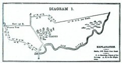
As an example of this plan of dividing lauds, the
following description of a farm laid out by "Metes and Bounds," is given:
"Beginning at a stone on the Bank of Doe River, at a point where the
highway from A. to B. crosses said river (see point marked C. on Diagram
1); thence 40° North of West 1110 rods to a large stump; thence 10' North
of West 90 rods; thence 15° West of North 80 rods to an oak tree (see
Witness Tree on Diagram 1); thence due East 150 rods to the highway;
thence following the course of the highway 50 rods due North; thence 5'
North of East 90 rods; thence 45° East of South 60 rods; thence 10° North
of East 300 rods to the Doe River; thence following the course of the
river Southwesterly to the place of beginning." This, which is a very
simple and moderate description by Metes and Bounds," would leave the
boundaries of the farm as shown in Diagram.
MERIDIANS AND BASE LINES.
 THE present system of Governmental Land Surveys was adopted
by Congress on the 7th of May, 1785. It has been in use ever since and is the
legal method of describing and dividing lands. It is called the "
Rectangular System," that is, all its distances and bearings are measured
from two lines which are at right angles to each other, viz. :+. These two
lines, from which the measurements are made, are the Principal Meridians, which
run North and South, and the Base Lines, which run East and West. These
Principal Meridians are established, with great accuracy, by anthroponomical
observations. Each Principal Meridian has its Base Line, and these two lines
form the basis or foundation for the surveys or measurement of all the lands
within the territory which they control.
THE present system of Governmental Land Surveys was adopted
by Congress on the 7th of May, 1785. It has been in use ever since and is the
legal method of describing and dividing lands. It is called the "
Rectangular System," that is, all its distances and bearings are measured
from two lines which are at right angles to each other, viz. :+. These two
lines, from which the measurements are made, are the Principal Meridians, which
run North and South, and the Base Lines, which run East and West. These
Principal Meridians are established, with great accuracy, by anthroponomical
observations. Each Principal Meridian has its Base Line, and these two lines
form the basis or foundation for the surveys or measurement of all the lands
within the territory which they control.
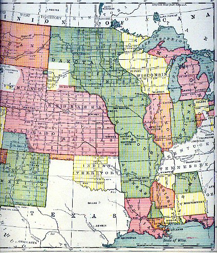
Diagram 2 shows all of the Principal Meridians and Base
Lines in the central portion of the United States, and from it the territory
governed by each Meridian and Base Line may be readily distinguished. Each
Meridian and Base Line is marked with its proper number or name, as are also
the Standard Parallels and guide (or auxiliary) Meridians.
Diagram 8 illustrates what is meant when this method is
termed the "Rectangular System," and how the measurements are based
on lines: which run at right angles to each other. The heavy line running North
and South (marked A. A.) represent: the Principal Meridian, in this case say
the 5th Principal Meridian. The heavy line running East and Wes, (marked B. B.)
is the Bas, Line. These lines are use( as the starting points or basis of all
measurements or surveys made in territory con trolled by the 5th Principal
Meridian. The same fact applies to all other Principal Meridians and their Base
Lines. Commencing at the Principal Meridian, at inter vale of six miles, lines
are run North and South, parallel to the Meridian. This plat is followed both
East am West of the Meridian throughout the territory controlled by the
Meridian.
|
 To inquire about volunteering for the IAGenWeb Project enter here and Join Our Team!
 Server space for the IAGenWeb Project site is provided by the Friends of Iowa Gen Web