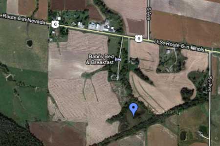
Kummer Cemetery aerial view (Image courtesy of Google)
Kummer Cemetery
The Kummer (sometimes wrongly spelled Kumer) cemetery gravestone listing is complete. Kummer is designated as a Pioneer Cemetery.
(Click on the ![]() icons to toogle information.)
icons to toogle information.)
History: Pauline Lillie's 1976 History
Gravestone Photos: Iowa Gravestone Photo Project
No photos have been taken yet.
Condition:
In good condition but needs work. Sumac will soon be cut down. Lilies cover the entire plot and will be removed. One broken stone was found, but will be easy to fix. Other stones need straightening. There is a wood fence around the plot. There are hopes to some day replace it. (updated 8 Nov 2012)
Plot Map: None
Directions and Location Maps:
Interactive Location Map w/GPS
Directions Map
From South Amana
- Turn left onto US-6 East (0.9 mi)
- Turn right (0.2 mi)
Ask permission to gain access.
Coordinates: Latitude 41.76719868984733, Longitude -91.94942951202393
Credits:
Read by: Bertha Kummer Tibben prior to 1976
Web page by: Stephen Williams
Published: Iowa County IAGenWeb Website, Oct 2009.
Media Source: Gravestone inscriptions and Pauline Lillie's Cemetery History
Web page by: Stephen Williams
Published: Iowa County IAGenWeb Website, Oct 2009.
Media Source: Gravestone inscriptions and Pauline Lillie's Cemetery History
Cemetery Listing: