Volume 2
By
CLARENCE RAY AURNER

 |
IOWA STORIES Volume 2 By CLARENCE RAY AURNER |  |
Transcribed by Sharon Elijah, June 21, 2013
|
 pg 42 |
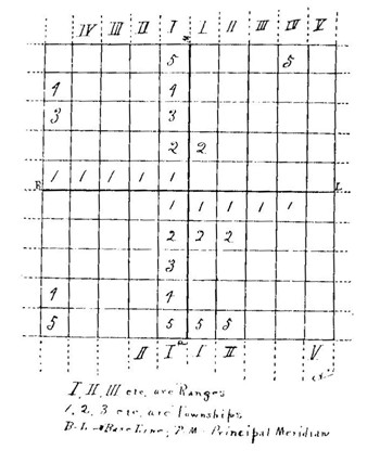
This is easy to see if one is willing to learn about the township in which the land described lies. Now there are different kinds of townships; and they must be carefully distinguished to avoid confusion. For example, the first, laid out as soon as the country was bought or taken from the Indians, were six miles square (See diagram). Lines were drawn six miles apart each way; and in these squares, which are six miles on each side, there are thirty-six smaller squares. Each of the smaller squares contains 640 acres of land and is, as one may see, one mile on each side. Therefore, when one speaks of a square mile or a section of land, he is really talking of 640 acres. By dividing this into four parts, one has a quarter of the whole, or 160 acres, which is one-half mile on each side and is the very common quarter-section farm of Iowa. Since a square mile is a section, thirty-six of these sections make a township of land, which is called a congressional or a geographical township. These can not be change by any one; they are to describe land, and one who knows the description of his land can find it on the map. If farms were taken in Iowa as some were (See Book One, pp. 70,71) before these townships were laid out by surveyors, their boundaries would be very uncertain and would need to be fixed after the lines had been properly run. |
 pg 44 |
In the first chapter it was said the first counties of Dubuque and Demoine were also each of them a single township. That is to say, they had some officers who performed the duties of township officers in the Territory of Michigan. It so happened that at first when the two counties were divided, each of the smaller divisions was also a single township, and this arrangement was not changed until a law for the making of smaller townships within the county was passed in 1840. Afterwards the county officers, who were called county commissioner at the time, as one will learn, had power to make new divisions. These are known as civil townships, because they are made for the purpose of government by the citizens who live in them. All who are born in the United States, or have come here from some other country and declared that they would become citizens, as they can after they have been here for five years, are citizens and have some interest in these divisions of the county. Men vote in these townships and the schools for their families are managed there. |
 pg 46 |
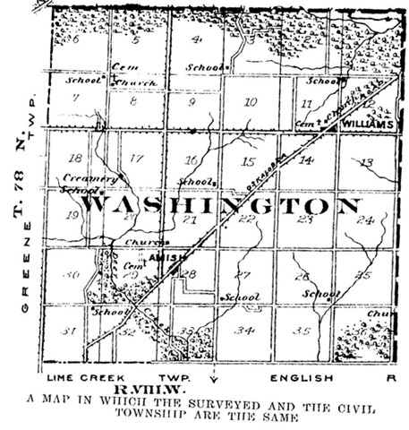
In the making of the first civil townships no attention was paid to the lines of congressional or geographical townships (those always six miles square and used to describe the land), unless it was the wish of the people in the township to have them that way. And if a stream prevented the voters from coming together in a township of that kind, all the land on one side would be put into some other civil township (See maps, pp. 44, 46). Thus things were arranged to accommodate the people. It was a long time before all the counties which have been mentioned were finally divided into townships as they are now. It ought to interest anyone to learn about the townships in his own county, and about the time that they were formed. |
Back to Muscatine Co. IAGenWeb, Index Page
Page created June 29, 2013 by Lynn McCleary