![]()
A BACKROADS TOUR OF LITTLE SWITZERLAND By Curt Harnack Photos by Gordon Lord & Margery Goergen 1957 |
Little Switzerland is one of the most scenic areas of Iowa, yet Sunday drivers on the main highways miss much of the beauty that awaits a traveler of the back roads. The topographic uniqueness of northeastern Iowa can partly be explained by geology, for it is a “driftless” region, where the glaciers did not reach. A tourist may notice the change in the rock foundations of barns: from the round smooth stones of the glacier country to the limestone slabs of “little Switzerland.”
Early state geologist, Professor Calvin, in his survey of 1894 is often credited with naming the section another Switzerland. He cited "the deep valleys, the high bluffs, the water- carved ridges, every topographic form indeed, are each and all wholly unique, for the other parts of the state furnish nothing with which they can in any way be compared."
Early boosters envisioned northeast Iowa as a mecca for the nation’s tourists, but much of the natural beauty of the scenery remains to this day undiscovered by native Iowans living easily within driving distance. The following one day’s trip is a guide to some of the back road sights of Clayton and Allamakee counties on gravel roads traversable even in wet weather. The aim of this tour is chiefly scenic and historic.
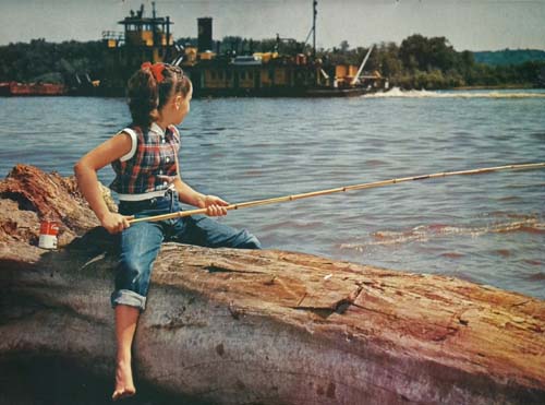
A Mississippi barge goes by a small girl fishing off a log.
STRAWBERRY POINT TO GUTTENBERG
Follow highway 13 north until clear road sign "Littleport 6." Turn right on gravel road to country store about three miles east. This is Communia, and all that remains of an 1847 French and German settlement. Turn directly north on gravel road to the Turkey river and the Motor Mill, designed by John Thompson (see IOWAN, May, 1956). Good camera spot and excellent fishing; people at nearby farm have key to the mill, which still contains some of the old equipment, including the grinding stones in the floor.
Return to Communia intersection and follow county road G, which angles southeast to sleepy, half-deserted Elkport and Garber. Turn northeast out of Garber on county road C, which comes out on highway 52 at Guttenberg. Follow "To Guttenberg" signs. If in doubt about direction of C road, follow the one most travelled. In Guttenberg on River Park Drive, the main street, observe interesting old buildings, some with the iron-lace balconies suggestive of New Orleans. This old river town, established in 1837, has the largest fresh water fish hatchery in the world. Visit the aquarium. Attractive park with view of river and dam.
GUTTENBERG TO McGREGOR
Take highway 52 toward Garnavillo and stop at century-old Ceres church, half-way to Garnavillo. Small picnic area with fireplace near the church. The pioneer rock church has been preserved in 19th century style by members of an association. Key may be obtained at neighboring farm house; see kerosene lamp chandelier, hand-made benches and altar; also, a museum containing many local relics. Ceres, named after Roman goddess of nature, was once a small village.
Proceed to Garnavillo, turning right on south edge of town on road between DX filling station and a red brick house; this is a good, highly scenic gravel road along the Buck Creek through a fertile agricultural valley, sheltered by high, thickly wooded bluffs. Road ends at intersection just a little north of Guttenberg. Turn left on the high road (route 7) going directly up the bluff. (The lower road along the river is so off-trail as to be difficult in wet weather.) Look back at Mississippi from near top of bluff for a fine view. Proceed north on road marked 7 until sign pointing way to Clayton, which is about a mile to the right. This intersection may be identified by a handsome red brick farmhouse slightly off to the left. Outskirts of Clayton are not promising, but the town is well worth a visit—nestled between bluffs, it seems leftover from the 19th century. Note “Boarding House" in faded letters on brick building across the street from the white frame church. On road turning right at bottom of hill is an old stone school; an interesting silica sand mine is farther south, but the road is very poor and at times runs almost on the railroad tracks.
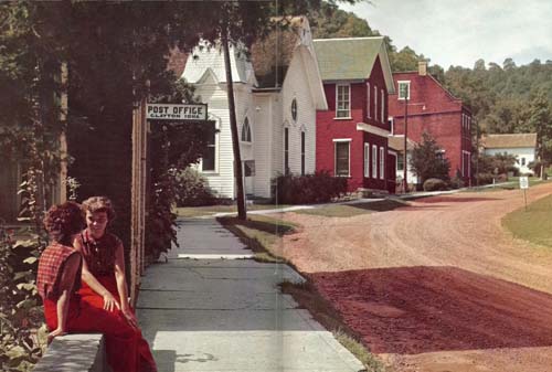
Two girls relax in front of Clayton's post office.
Return to route 7 and drive north until intersection with black-top road, 340, turning right for Pikes Peak State Park. View from 540 foot bluff is 20 miles or more up the river, and for trail climbers: a rugged ravine and "pictured rocks" made up of many- colored sands. Proceed on 340 into McGregor, noting rather run-down house where Ringling brothers grew up. Turn west on 13-18 for several blocks to Moody’s museum for excellent collection of Midwest antiques, including an old country store, the post office from Waukon junction, a walnut bar from Clayton tavern (in use 104 years ago in a riverfront saloon), and an old jail. Admission charge of 25¢ and 10¢—well worth it. Drive through main street of McGregor. Emma Bigbear will probably be selling Indian trinkets in front of Scenic Hotel.
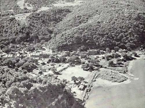
Scenic McGregor snuggles in the Mississippi River bluffs in this aerial photograph.
While in McGregor, you can also visit Spook Cave and Beulah Falls (seven miles west) and, from mid-July to mid-August, the American lotus beds along the river. The pontoon bridge from Marquette crosses to Prairie du Chien, dating back to 1685, and a number of places of interest including the famed Dousman home, Villa Louis, now open to the public, and old Fort Crawford.
McGREGOR TO WAUKON
Follow highway 15 and visit Effigy Mounds National Monument, allowing at least forty-five minutes, for the walk is long and steep; fine hiking area, wonderful views of the river.
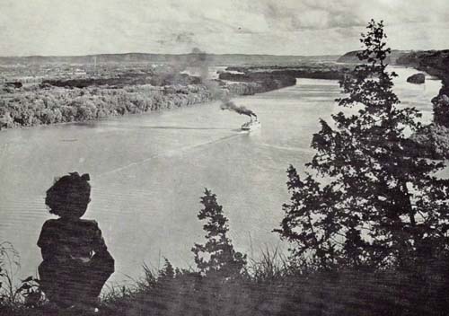
A Mississippi River excursion boat passes by Effigy Mounds National Monument.
Rugged bluffs of Iowa shore are in background.
Continue on 13 until junction with 564, turning right. Follow new, excellent road through Waukon junction to Harpers Ferry and some of the best scenery of the trip. Drive through Harpers Ferry to black-top street running north out of town, where it turns to gravel; passes extensive lumbering industry and many summer cottages. Follow this road to Lansing, and though it is poorly marked, at most crucial intersections you’ll find a Lansing sign with a painted fish for an arrow. Bluffs and valleys make for unsurpassed beauty. At Wexford creek, note stone church on the left, said to be the oldest church in operation west of the Mississippi. From Effigy Mounds to Lansing by this route takes a leisurely hour. Coming into Lansing along the river, note impressive old stone courthouse with white pillars, now a residence. Well-worth lingering in Lansing for picturesque streets, houses, business buildings. Leave on paved highway 9, which follows a high ridge with sweeping vistas, where you can see to Minnesota. (Alternate route, if time permits: go north out of Lansing on 182 until you meet the Upper Iowa river and, soon after, county road A leading off to the left. This road generally follows the Upper Iowa river, is highly scenic; you travel through famous trout country. On highway 15, turn south to Waukon.)
WAUKON TO POSTVILLE
(one and one half hours)Follow East Main street out of Waukon, noticing octagonal stone house on left, just outside business district. Proceed on gravel road which the Waukon Charmber of Commerce is marking "Scenic Trail." Take the second mile right and follow this road to Waterville. This trip along the Paint Creek will be one of the high points of the day. If weather is wet, turn right at `Waterville on 575 to highway 13; otherwise, in Waterville proceed east out of town, and on first road branching right (over bridge and railroad tracks) continue to highway 13. This stretch of road takes motorist through a fine canyon. Follow 13 to Rossville, turning south on M, a ridge road. When you come to the Yellow River, this is Volney, bear right and follow the main gravel road south to Monona. Take highway 18 from Monona to Postville.
POSTVILLE TO STRAWBERRY POINT
(one and one half hours)Proceed on 18 to Clermont, noting big mansion of former Governor Larrabee on bluff overlooking town; he was a mill owner, and the house is still in the family. Follow black-top 172 into Elgin, a scenic little town with trees on its business street. Continue through Elgin on county K road directly east; this gravel road is wide and follows the Turkey river part way. At Gunder turn right and follow gravel road south-eastward to highway 13, just outside Elkader. In Elkader, on the banks of the Turkey river, you will pass interesting old courthouse with tower dating back to 1849. Attractive falls at old dam and mill site. Last lap of journey on highway I3 will take you into Strawberry Point.
This trip can be done in one day, but a day and a half to two days is recommended. This tour makes Mc Gregor a good stopping place. There is a hotel there and also motels. Accommodations are available in other towns along the route. More tourist literature is available from this section of Iowa than any other we know about. The Chambers of Commerce at Guttenberg, McGregor and Waukon have material available. A map put out by Waukon has good suggestions for adding to the northern part of this tour.
There are several state parks in the area including the Effigy Mounds, Yellow River State Forest, Turkey River Mounds, Fish Farm Mounds, Echo Valley, Backbone and Bixby. The latter two are near Strawberry Point which also has a state fish hatchery. Backbone has cabins and overnight camping sites.
~Source: The Iowan, June-July 1957
~Transcribed by Errin Wilker~Note: Although this article was written over 50 years ago, and the directions will not be exactly right, today anyone with a map of Clayton & Allamakee counties will still be able to take their own scenic tour through the little Switzerland of Iowa!!
~*~*~
Return to the
Odds & Ends Index
Return to Clayton County Index