 |
|
 |
|
 |
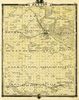
Year: 1850 Publisher: drawn and published by Guy H. Carleton, Dep. Sur. U.S. Description: Sectional map of the state of Iowa, compiled from the United States surveys. IMAGE SIZE: 126 KB |
 |
Year: 1855 Source: Map of Iowa Publisher: Edward Mendenhall, Cincinnati, 1855 IMAGE SIZE: 61 KB |
 |
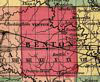
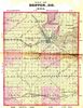
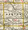
Year: 1856 Source: Parker's Sectional & Geological Map of Iowa Publication Author: Nathan H. Parker author of "Iowa As It Is" Clinton Io. 1856. Published: New York, Chicago, 1856. IMAGE SIZE: 106 KB |
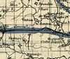 |
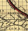
Year: 1857 Source: Iowa Central Air Line Rail Road, and its connections with the Iowa Central line. Publisher: J.H. Colton & Co, New York, c1857 IMAGE SIZE: 66 KB |
 |
Year: 1859 Source: Johnson's Map of Illinois, Iowa, & Missouri Publication Author: Johnson, A. J. (Alvin Jewett), 1827-1884. Published: New York, 1859, c1857. IMAGE SIZE: 96 KB |
 |
Year: 1862 Source: Colton's Iowa Publisher: New York: G.W. & C.B. Colton IMAGE SIZE: 72 KB |
 |
Year: 1864 Source: Johnson's Map of Iowa and Nebraska Publisher: New York: A. J. Johnson IMAGE SIZE: 77 KB |
 |
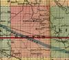
Year: 1868 Publisher: G.W. & C.B. Colton & Co, New York, 1868 Description: Map showing the Burlington Cedar Rapids and Minnesota Railway and its connections. IMAGE SIZE: 74 KB |
 |
Year: 1871 Publisher: G.W. & C.B. Colton & Co, New York, 1871 Description: Map showing location of lands for sale by the railroads and land companies. IMAGE SIZES: 72 and 83 KB |
 |
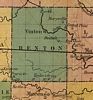
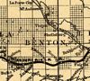
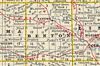
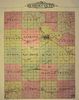
Year: 1872 Source: Atlas of Benton County, Iowa Publication Author: Harrison & Warner Published: Marshalltown, Iowa, 1872 Note: Landowners identified IMAGE SIZE: 102 KB |
 |
Year: 1875 Source: A. T. Andreas' Illustrated Historical Atlas of the State of Iowa Engraved & printed by Chas. Shober & Co., Props. of Chicago Lithographing Co. Published by: Andreas Atlas Co., Lakeside Building, Chicago, Ills. Note: Landowners identified IMAGE SIZE: 814 KB |
 |
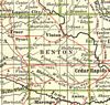
Year: 1877 Source: Gray's New Map of Iowa Publisher: Philadelphia: O.W. Gray & Son IMAGE SIZE: 48 KB |
 |
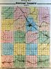
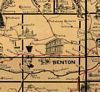
Year: 1878 Source: The 1878 History of Benton County, Iowa Publisher: Chicago: Western Historical Company IMAGE SIZE: 247 KB |
 |
Year: 1879 Source: Rand, McNally & Co.'s Business Atlas Publisher: Chicago: Rand, McNally & Co., Printers, Engravers and Publishers. 1878-9 IMAGE SIZE: 154 KB |
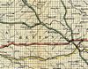 |
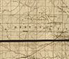
Year: 1881 Source: Railroad Map of Iowa Publisher: Railroad Commissioners, Des Moines, 1881 IMAGE SIZE: 214 KB |
 |
Year: 1890 Source: Map of Iowa Publisher: Rand McNally, Chicago IMAGE SIZE: 86 KB |
 |
Year: 1897 Source: Galbraith's Railway Mail Service Maps, Iowa Publisher: Chicago, 1897, c1898. Description: Designed by Chicago railway mail clerk Frank H. Galbraith to help employees of the Railway Mail Service quickly locate counties and post offices. IMAGE SIZE: 126 KB |
 |
Year: 1901 Source: 1901 Standard Atlas of Benton County, Iowa Publication Author: Geo. A. Ogle & Co., Engravers. Published: 134 Van Buren St. Chicago Note: Landowners identified |
 |
Year: 1902 Source: Century Atlas Publisher: Buffalo: The Matthew-Northrup Company IMAGE SIZE: 78 KB |
 |
Year: 1904 Source: The Iowa State Atlas Publisher: Iowa Publishing Company of Davenport IMAGE SIZE: 125 KB |
|
|