![]()
Allamakee county Township Map with notes |
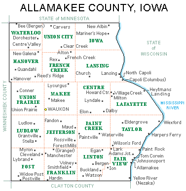
Allamakee county Townships
This is a historical map to assist Allamakee co.
researchers.
It does not show all of the pioneer settlements, is not drawn to
scale and is not entirely accurate (see the notes below).
PLEASE use it only as a guide!
Notes about the above map
Mike Healy, an Allamakee Co. researcher (deceased), wrote:
"This map shows Paint Rock in Fair View Township. Paint Rock and it's Cemetery -- St. Joseph's is in Taylor Township.
The map also shows the historic Settlement of Wexford in Taylor Township. Wexford and it's Church and Cemetery Immaculate Conception Cemetery are in Lafayette Township."
Wexford:
-The 1872 Andreas Atlas of Allamakee shows Wexford in Lafayette twp.
-The 1917 plat map shows Wexford in Lafayette twp.
-From History of Allamakee County, Iowa, 1882, by W. E. Alexander, Chapter 6: "Wexford --By right of priority of settlement, this
community, situated in the southern portion of Lafayette Township, some three miles from the Mississippi, on Priest Cooley (or creek), should have been ........" [contributed by S. Ferrall]
Paint Rock:
-The 1859 Woodcock Plat map shows Paint Rock in what LOOKS like Fairview twp. but when I compare some of the other plat maps, Taylor twp. has an irregular southern border that dips down into Fairview twp. This is not shown on this map.
-The 1882 plat map doesn't show Paint Rock (at least I don't see it) but it does show St. Joseph's Cath. Church in section 21 of Taylor twp.
-The 1917 plat map clearly shows Paint Rock in Taylor twp. but not as a "place" rather as a "land feature"
- From History of Allamakee County, Iowa, 1882, by W. E. Alexander, Chapter 6: "Paint Rock --Was another river point that was to be, on Harper's Channel, in Fairview township, section 3, near the Taylor line.........."
-From the Iowa Dept. of Natural Resources web-site: "Paint Rock takes its name from figures painted by Indians on a high, limestone bluff overlooking the Mississippi near the south end of the Paint Rock unit. A Catholic parish located nearby is also known as Paint Rock."
-Paint Rock cemetery (associated with the church) is in Taylor twp.
[contributed by S. Ferrall]
Does anyone have another map of the townships of
Allamakee Co. to submit for our web-site?
Allamakee Co. Township formation
Return to Land Records Index
Home