|
|
Shelby County |

1911 LINCOLN TOWNSHIP PLAT MAPClick on map to enlarge.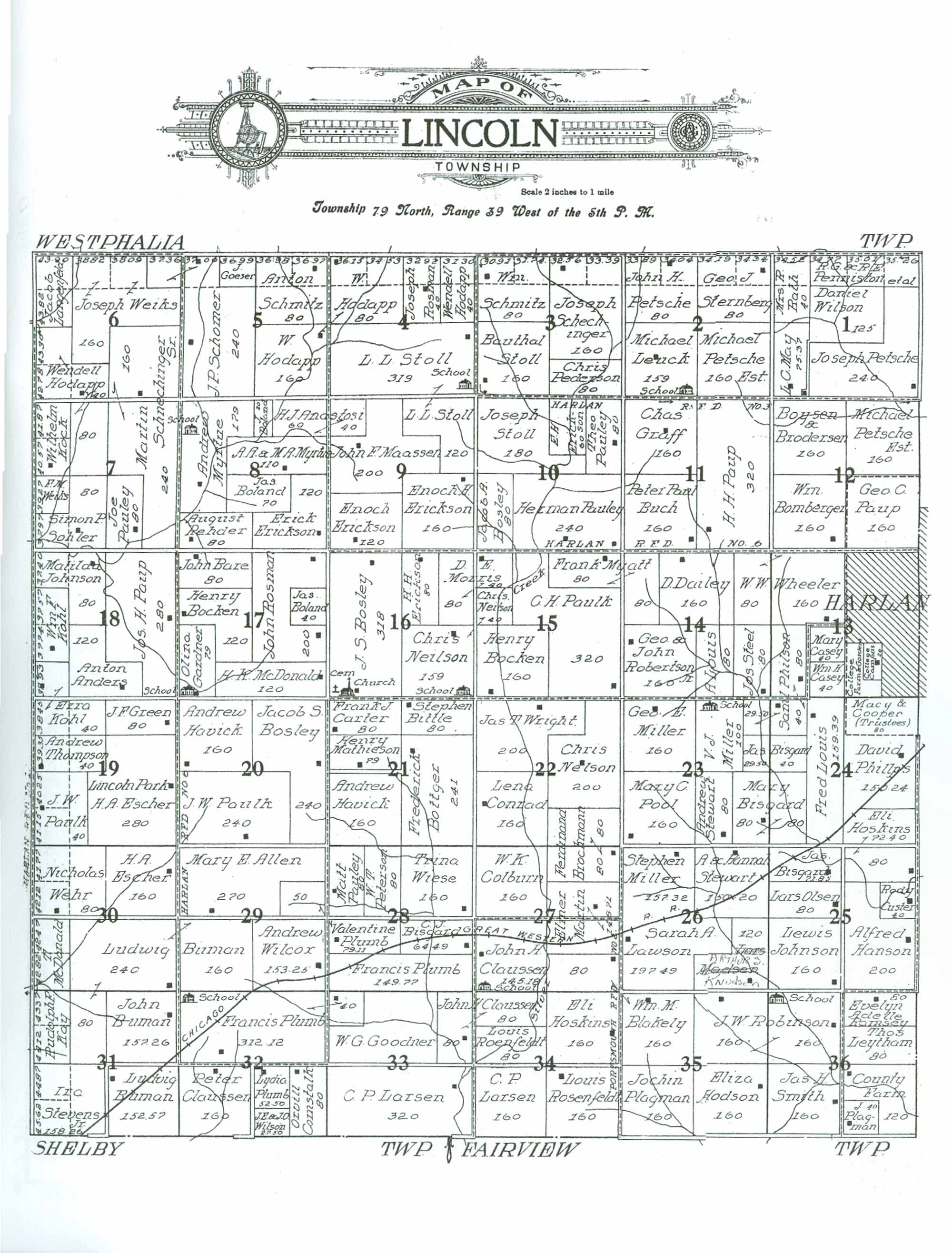 1911 LINCOLN TOWNSHIP RESIDENTS
|
| LAST NAME | FIRST NAME | SECTION # | ACRES | COMMENTS |
|---|---|---|---|---|
| Allen | Mary E. | 29 | 270 | |
| Anastosi | H. J. | 8 | 60 | |
| Anastosi | H. J. | 9 | 40 | Owns adjoining property in Section 8 |
| Anders | Anton | 18 | 120 | |
| Bare | John | 17 | 80 | |
| Bisgard | C. J. | 28 | 64.49 | Map states 64.49 acres, appears may be more like 80 from Section totals |
| Bisgard | Jas. | 24 | 40 | |
| Bisgard | Jas. | 23 | 29.5 | Owns adjoining property in Section 24 |
| Bisgard | Jas. | 25 | 71.85/80 | Map indicates 71.85 acres; may be morelike 80 |
| Bisgard | Mary | 23 | 80 | Owns adjoining property in Section 24 |
| Bisgard | Mary | 24 | 80 | Owns adjoining property in Section 23 |
| Bittle | Stephen | 21 | 80 | |
| Blakely | Wm. M. | 27 | 80 | Owns adjacent property in Section 35 |
| Blakely | Wm. M. | 35 | 160 | |
| Bocken | Henry | 15 | 160 | |
| Bocken | Henry | 17 | 120 | |
| Boland | J. | 8 | 20 | |
| Boland | Jas. | 8 | 70 | |
| Boland | Jas. | 17 | 40 | |
| Bomberger | Wm. | 12 | 160 | |
| Bosley | J. S. | 16 | 318 | "Church" & "Cemetery" located on SW area of property; assume 2 acres allotted to them |
| Bosley | Jacob A. | 10 | 80 | |
| Bosley | Jacob S. | 20 | 240 | |
| Bottger | Frederick | 21 | 241 | |
| Boysen & Brodersen | 12 | 160 | No first names provided | |
| Brockmann | Ferdinand | 22 | 80 | |
| Brockmann | Ferdinand | 27 | 80 | Owns adjoining property in Section 22 |
| Buch | Peter Paul | 11 | 160 | |
| Buman | John | 31 | 157.26 | |
| Buman | Ludwig | 29 | 160 | Owns adjoining property in Section 30 |
| Buman | Ludwig | 30 | 240 | Owns adjoining properties in Sections 29 and 31 |
| Buman | Ludwig | 31 | 80 | |
| Buman | Ludwig | 31 | 152.57 | |
| Carter | Frank J. | 21 | 80 | |
| Casey | Mary | 13 | 40 | |
| Casey | Wm. H. | 13 | 40 | |
| Cemetery | 16 | 1 | Located on SW corner of property owned by J. S. Bosley | |
| Church | 16 | 1 | Located on SW corner of property owned by J. S. Bosley | |
| Claussen | John H. | 27 | 145.18 | "School" located on SW corner of property |
| Claussen | John H. | 33 | 80 | Owns adjoining property located in Section 34 |
| Claussen | John H. | 34 | 80 | Owns adjoining property in Section 33 |
| Claussen | Peter | 32 | 160 | |
| Colburn | W. K. | 27 | 160 | |
| College Campus | 13 | 20 | ||
| College Farm & Gardens | 13 | 40 | ||
| Comstalk | Orvill | 32 | 80 | |
| Conrad | Lena | 22 | 160 | |
| County Farm | 36 | 120 | ||
| Custer | Rody | 25 | 40 | |
| Dailey | D. | 14 | 160 | |
| Erickson | E. H. | 10 | 60 | |
| Erickson | Enoch | 9 | 120 | |
| Erickson | Enoch H. | 9 | 160 | |
| Erickson | Erick | 8 | 120 | |
| Erickson | H. H | 16 | 80 | |
| Escher | H. A. | 19 | 280 | "Lincoln Park" |
| Escher | H. A. | 30 | 160 | |
| Gardner | Olina | 17 | 79 | "School" located on SW corner of property; assume 1 acre allotted to it. |
| Goeser | J. P. | 5 | 40 | |
| Goodner | W. G. | 33 | 200 | |
| Graff | Chas. | 11 | 160 | |
| Green | J. F. | 19 | 80 | |
| Hanson | Alfred | 25 | 200 | |
| Harlan (township) | 13 | 260 | Acreage estimated from Section totals | |
| Havick | Andrew | 20 | 160 | |
| Havick | Andrew | 21 | 160 | |
| Hodapp | W. | 4 | 80/160 | Map indicates 80 acres, is actually 160 |
| Hodapp | W. | 5 | 160 | |
| Hodapp | Wendell | 4 | 40/80 | Map indicates 40 acres, is actually 80 |
| Hodapp | Wendell | 6 | 40/120 | Map indicates 40 acres, is actually 120 |
| Hodapp | Wendell | 7 | 80 | |
| Hodson | Eliza | 35 | 160 | |
| Hoskins | Eli | 24 | 72.4 | Owns adjoining property in Section 25 |
| Hoskins | Eli | 25 | 80 | Owns adjoining property in Section 24 |
| Hoskins | Eli | 34 | 160 | |
| Johnson | Lewis | 25 | 160 | |
| Johnson | Matilda | 18 | 80/120 | Map reflects 80 acres, actually 120 |
| Kay | Rudolph | 31 | 80 | |
| Knudsen | Arthur S. | 26 | 120 | |
| Kock | Wilhelm | 7 | 80 | |
| Kohl | Ezra | 18 | 40 | |
| Kohl | Ezra | 19 | 40/80 | Map shows 40 acres, is actually 80 |
| Kohl | Wm. F. | 18 | 80 | |
| Langenfeld | Jacob | 6 | 80 | |
| Larsen | C. P. | 33 | 320 | |
| Larsen | C. P. | 34 | 160 | |
| Lawson | Sarah A. | 26 | 197.49 | |
| Leuck | Michael | 2 | 159 | "School" on SE corner of property; assumed 1 acre alloted to it. |
| Leytham | Thos. | 36 | 80 | |
| Louis | A. | 14 | 80 | |
| Louis | Fred | 24 | 159.39 | |
| Maassen | John F. | 9 | 200 | |
| Macy & Cooper (Trustees) | 24 | 80 | ||
| Martin | Elmer | 27 | 148.71 | |
| Mathieson | Henry | 21 | 79 | |
| May | L. C. | 1 | 75.37 | |
| McDonald | H. K. | 17 | 120 | |
| McDonald | T. | 30 | 80 | |
| Miller | Geo. E. | 23 | 160 | |
| Miller | Stephen | 26 | 157.32 | |
| Miller | V. J. | 23 | 100 | "School" located at north end of property |
| Morris | D. E. | 15 | 40 | Owns adjoining property in Section 16 |
| Morris | D. E. | 16 | 80 | Owns adjoining property in Section 15 |
| Myatt | Frank | 14 | 80 | Owns adjoining property in Section 13 |
| Myatt | Frank | 15 | 80 | Owns adjoining property in Section 14 |
| Myrtue | A. A. & M. A. | 8 | 110 | |
| Myrtue | Andrew | 8 | 179 | "School" located in NW area of property, assume 1 acre allotted to it. |
| Neilson | Chris | 15 | 40 | Owns adjacent property in Section 16 |
| Neilson | Chris | 16 | 159 | "School" located in SE area of property; assume 1 acre allotted to it |
| Nelson | Chris | 22 | 200 | |
| Olsen | Lars | 25 | 80 | |
| Pauley | Herman | 10 | 240 | |
| Pauley | Joe | 7 | 80 | |
| Pauley | Matt | 28 | 80 | |
| Pauley | Theo | 10 | 80 | |
| Paulk | C. H. | 15 | 320 | |
| Paulk | J. W. | 19 | 40/120 | Map shows 40 acres, is actually 120 |
| Paulk | J. W. | 20 | 240 | |
| Paup | Geo. C. | 12 | 160 | |
| Paup | H. H. | 11 | 320 | |
| Paup | Jos. H. | 18 | 280 | |
| Pederson | Chris | 3 | 80 | |
| Penniston et al | R. G. & R. E. | 1 | 120 | |
| Peterson | W. T. | 28 | 80 | |
| Petsche | John H. | 2 | 80/160 | Map indicates 80 acres, actually 160 |
| Petsche | Joseph | 1 | 240 | |
| Petsche Est. | Michael | 2 | 160 | |
| Petsche Est. | Michael | 12 | 160 | |
| Phillps | David | 24 | 150.24/168 | Map indicates 150.24 acres; acreage estimated to be more like 168 using Section total |
| Philson | Saml | 13 | 80 | Owns adjoining property in Section 24 |
| Philson | Saml | 23 | 29.5 | Owns adjoining property in Section 24 |
| Philson | Saml | 24 | 40 | Owns adjoining properties in Sections 23 and 13 |
| Plagman | J. | 36 | 40 | |
| Plagman | Jochin | 35 | 160 | |
| Plumb | Francis | 28 | 149.77/160 | Map states 149.77 acres, appears may be more like 160 from Section totals |
| Plumb | Francis | 32 | 312.12 | "School" located in NW corner of property |
| Plumb | Francis | 33 | 40 | Owns adjoining property located in Section 33 |
| Plumb | Lydia | 32 | 52.5 | |
| Plumb | Valentine | 28 | 79.11 | Owns adjacent property in Section 29 |
| Plumb | Valentine | 29 | 50 | Owns adjacent property in Section 28 |
| Pool | Mary C. | 23 | 160 | |
| Ramsey | Evelyn Adelle | 36 | 80 | |
| Rehder | August | 8 | 80 | |
| Robertson | Geo. & John Jr. | 14 | 160 | |
| Robinson | J. W. | 35 | 160 | Owns adjoining property in Section 36 |
| Robinson | J. W. | 36 | 160 | "School" located on NW corner of property |
| Roenfeldt | Louis | 34 | 80 | |
| Rosenfeldt | Louis | 34 | 160 | |
| Rosman | John | 17 | 200 | |
| Rosman | Joseph | 4 | 40/80 | Map indicates 40 acres, is actually 80 |
| Roth | Mrs. R. | 1 | 40/80 | Map shows 40 acres, actually 80 |
| Schechinger | Joseph | 3 | 160/240 | Map indicates 160 acres, is actually 240 |
| Schmitz | Anton | 5 | 80/160 | Map shows 80 acres, is actually 160 |
| Schmitz | Wm. | 3 | 80/160 | Map indicates 80 acres, is actually 160 |
| Schnechinger, Sr. | Martin | 6 | 160 | Owns adjoining property in Section 7 |
| Schnechinger, Sr. | Martin | 7 | 240 | Owns adjoining property in Section 6 |
| Schomer | J. P. | 5 | 240 | |
| School | 2 | 1 | Located on SE corner of property owned by Michael Leuck | |
| School | 4 | 1 | Located on SE corner of property owned by L. L. Stoll | |
| School | 8 | 1 | Located on NW area of property owned by Andrew Myrtue | |
| School | 16 | 1 | Located on SE corner of property owned by Chris Neilson | |
| School | 17 | 1 | Located on SW corner of property owned by Olina Gardner | |
| School | 23 | 0 | Located at north end of property owned by V. J. Miller | |
| School | 27 | 0 | Located on SW corner of property owned by John H. Claussen | |
| School | 32 | 0 | Located on NW corner of property owned by Francis Plumb | |
| School | 36 | 0 | Located on NE corner of property owned by J. W. Robinson | |
| Smith | Jas. H. | 36 | 160 | |
| Sohler | Simon P. | 7 | 80/120 | Map shows 80 acres, is actually 120 |
| Steel | Jos. | 14 | 80 | |
| Sternberg | Geo. J. | 2 | 80/160 | Map shows 80, actually 160 acres |
| Stevens, Jr. | Ira | 31 | 158.26 | |
| Stewart | A. & Hannah | 26 | 150.2 | |
| Stewart | Andrew | 23 | 80 | |
| Stoll | Bauthal | 3 | 160 | |
| Stoll | Joseph | 10 | 180 | |
| Stoll | L. L. | 4 | 319 | "School" in SE corner of property, assumed 1 acre allotted to it. Owns adj. prop in Sec. 9 |
| Stoll | L. L. | 9 | 120 | |
| Thompson | Andrew | 19 | 40/80 | Map shows 40 acres, is actually 80 |
| Wehr | Nicholas | 30 | 80/160 | Map indicates 80 acres, actually 160 acres |
| Weiks | F. M. | 7 | 40 | |
| Weiks | Joseph | 5 | 40 | Owns adjoining property in Section 6 |
| Weiks | Joseph | 6 | 160/280 | Map indicates 160 acres, is actually 280 |
| Wheeler | W. W. | 13 | 160 | |
| Wheeler | W. W. | 14 | 80 | Owns adjoining property in Section 13 |
| Wiese | Trina | 28 | 160 | |
| Wilcox | Andrew | 29 | 153.25/160 | Map shows 153.25 acres; may be more like 160 with Section totals |
| Wilson | Daniel | 1 | 125 | |
| Wilson | J. E. & J. O. | 32 | 27.5 | |
| Wright | Jas. T. | 22 | 200 |
Transcribed by Denise Wurner, January, 2013.
Please notify the Shelby Coordinator of any transcription errors.