|
|
Shelby County |

1911 DOUGLAS TOWNSHIP PLAT MAPClick on map to enlarge.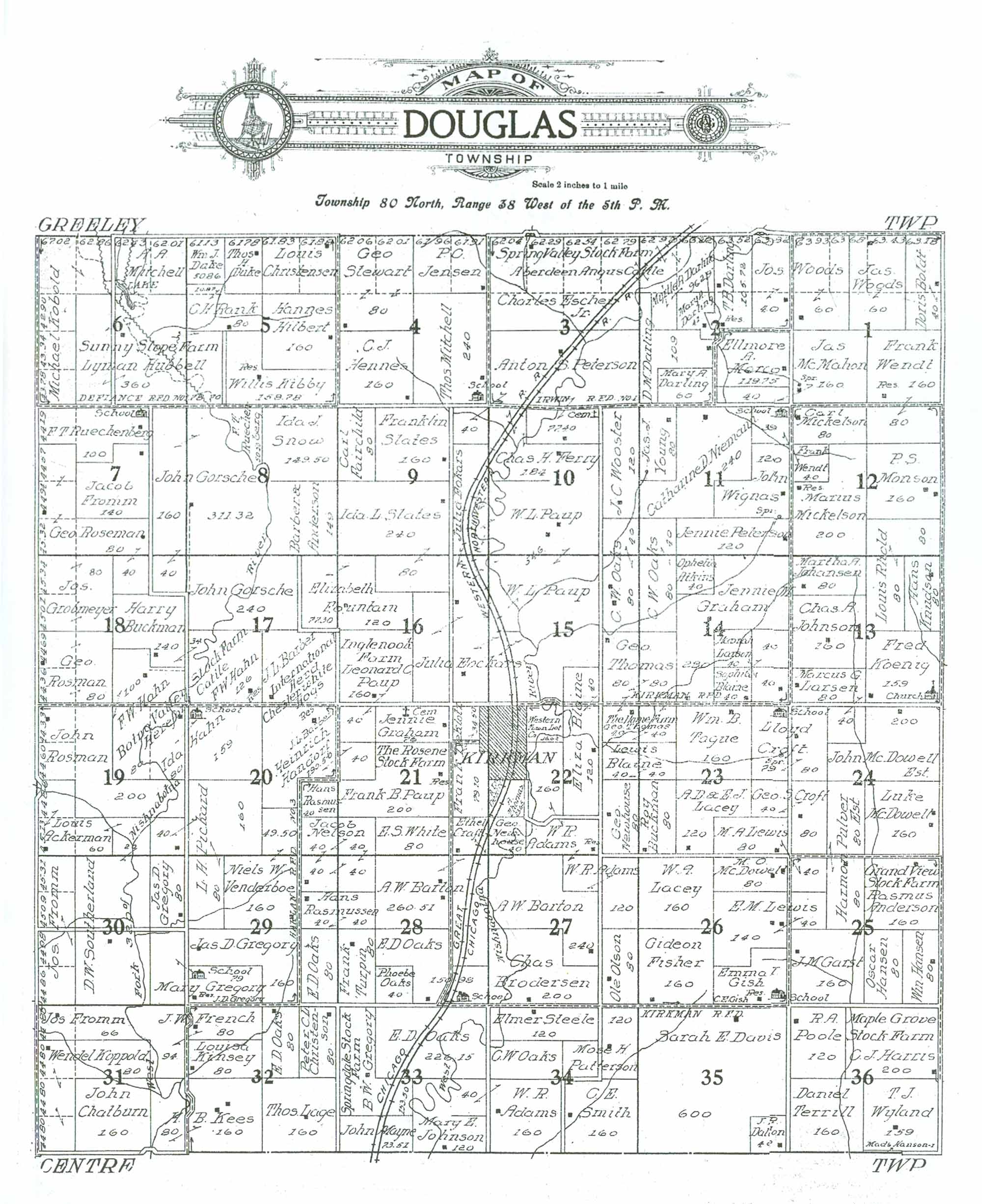 1911 DOUGLAS TOWNSHIP RESIDENTS
|
| LAST NAME | FIRST NAME | SECTION # | ACRES | COMMENTS |
|---|---|---|---|---|
| Ackerman | Louis | 19 | 140 | |
| Adams | W. R. | 22 | 163.98 | Owns property in adjoining Section 27 |
| Adams | W. R. | 27 | 120 | |
| Adams | W. R. | 33 | 40 | Owns property in adjoining Section 34 |
| Adams | W. R. | 34 | 160 | |
| Anderson | Barbera | 8 | 149 | Stated acreage questionable; total for Section is 20 acres excessive |
| Anderson | Rasmus | 25 | 160 | "Grand View Stock Farm" |
| Atkins | Ophelia | 14 | 40 | |
| Barber | J. L. | 17 | 160 | "International Herd Chesterwhite Hogs" |
| Barton | A. W. | 27 | 240 | |
| Barton | A. W. | 28 | 260.51/290 | Map reflects acreage of 260.51; understated by approx. 30 acres? Section totals do not reconcile. |
| Blaine | Eliza | 22 | 120 | |
| Blaine | Lewis | 22 | 40 | |
| Blaine | Lewis | 23 | 40 | |
| Blaine | Sophia | 14 | 80 | 2 parcels, not adjoining |
| Boldt | Doris | 1 | 80 | Map reflects 40, but she has 2 parcels. |
| Brodersen | Chas. | 27 | 200 | |
| Buckman | Harry | 17 | 34 | Owns property in adjoining Section 18 |
| Buckman | Harry | 18 | 140 | Owns property in adjoining Section 17 |
| Buckman | Roy | 23 | 80 | |
| Cemetery | 10 | 2.6 | ||
| Cemetery | 21 | 4 | Assumed 4 acres remaining from Jennie Graham's property, where located | |
| Chatburn | John | 31 | 160 | |
| Chatburn | John | 31 | 160 | |
| Christensen | Louis | 5 | 80 | |
| Christenson | Peter C. | 32 | 80 | |
| Church | 13 | 1 | Located on SW corner of Fred Koenig's property | |
| Craft | Ethel | 21 | 40 | |
| Croft | Geo. S. | 23 | 40 | Owns property in adjoining Section 24 |
| Croft | Geo. S. | 24 | 80 | Owns property in adjoining Section 23 |
| Croft | Lloyd | 23 | 79 | "School" on property; Assumed 1 acre of land designated to it. |
| Croft | Lloyd | 24 | 80 | Owns property in adjoining Section 23 |
| Dalton | J. R. | 35 | 40 | |
| Darling | D. M. | 2 | 109 | |
| Darling | Mary A. | 2 | 101 | 2 spearate parcels in same Section 2, 41 & 60 acres; overstated by 10 acres +/-? |
| Darling | Myrtle A. | 2 | 96.29 | 2 separate parcels in same Section 2. Overstated by 10-20 acres +/1? |
| Darling | T. B. | 2 | 105.72 | Acreage overstated by 20 acres+/-? Section totals excessive as shown. |
| Davis | Sarah E. | 35 | 600 | |
| Dekin (?) | A. ? | 22 | 16.35 | Acreage estimated from Section total |
| Deklo?z | Frank | 21 | 113.6 | |
| Duke | Thos. H. | 5 | 40 | |
| Duke | Wm. J. | 5 | 50.86 | |
| E?ckars | Julia | 15 | 150 | Owns property in adjoining Section 16; acreage estimated from Section total |
| E?ckars | Julia | 16 | 280 | Owns property in adjoining Section 15 |
| Escher Jr. | Charles | 2 | 40 | Estimated; Owns property in adjoining Section 3; "Spring Valley Stock Farm, Aberdeen Angus Cattle" |
| Escher Jr. | Charles | 3 | 320 | Owns prop. In adjoining Section 2. "Spring Valley Stock Farm, Aberdeen Angus Cattle" |
| Fairchild | Carl | 9 | 80 | |
| Ferry | Chas. H. | 10 | 184 | |
| Fisher | Gideon | 26 | 160 | |
| Fokars | Julia | 9 | 120 | |
| Fountain | Elizabeth | 16 | 120 | Owns property in adjoining Section 17 |
| Fountain | Elizabeth | 17 | 80 | Owns property in adjoining Section 16 |
| French | J. W. | 31 | 94 | |
| French | J. W. | 32 | 80 | Owns property in adjoining Section 31 |
| Fromm | Jacob | 7 | 140 | |
| Fromm | Jos. | 30 | 160 | |
| Fromm | Jos. | 31 | 66 | Owns property in adjoining Section 30 |
| Garst | J. M. | 25 | 160 | |
| Gish | Emma T. | 26 | 100 | "School" located on property, SE corner; Residence of C. E. Gish located on property |
| Gorsche | John | 7 | 160 | |
| Gorsche | John | 8 | 311.32 | Stated acreage questionable; total for Section is 20 acres excessive |
| Gorsche | John | 18 | 40 | Owns property in adjoining Sections 17 and 7 |
| Gorsche | John | 17 | 240 | |
| Graham | Jennie | 21 | 76 | "Cemetery " located on property; acreage assumed at 4 acres |
| Graham | Jennie M. | 14 | 280 | |
| Gregory | B. W. | 33 | 153.5 | "Springdale Stock Farm" |
| Gregory | Jas. D. | 29 | 160 | |
| Gregory | Jas. D. | 30 | 80 | |
| Gregory | Mary | 30 | 80 | Owns property in adjoining Section 29 |
| Gregory | Mary | 29 | 79 | "School" on property; residence of J. D. Gregory on property; owns prop. In adjoining Sec. 30 |
| Grobmeyer | Jos. | 18 | 160 | |
| Hahn | F. W. | 17 | 126 | "Botne Valley Stock Farm Hereford Cattle." Owns property in adjoining Sections 18 & 19 |
| Hahn | F. W. | 18 | 100 | |
| Hahn | F. W. | 19 | 80 | "Botne Valley Stock Farm Hereford Cattle." Owns property in adjoining Sections 18 & 17 |
| Hahn | Ida | 19 | 80 | Owns property in adjoining Section 20 |
| Hahn | Ida | 20 | 159 | "School" located on property; assume remaining 1 acre allocated to School |
| Handorf | Heinrich | 20 | 190.5 | Owns property in adjoining Section 21 |
| Handorf | Heinrich | 21 | 40 | Owns property in adjoining Section 20 |
| Hansen | Oscar | 25 | 80 | |
| Hansen | Wm. | 25 | 80 | |
| Hanson | Mads | 36 | 1 | Sliver of property along south-westerly edge of T. J. Wylands property |
| Harris | C. J. | 36 | 200 | "Maple Grove Stock Farm" |
| Hennes | C. J. | 4 | 160 | |
| Hilbert | Hannes | 5 | 160 | |
| Hubbell | Lyman | 5 | 70 | Owns property in adjoining Section 6; "Sunny Slope Farm" |
| Hubbell | Lyman | 6 | 360 | Owns property in adjoining Section 5; "Sunny Slope Farm" "Lake" located on property |
| Jensen | P. C. | 4 | 80 | |
| Johansen | Martha A. | 13 | 80 | |
| Johnson | Chas A. | 13 | 160 | |
| Johnson | Mary E. | 33 | 120 | |
| Kees | H. B. | 31 | 80 | |
| Kees | H. B. | 32 | 160 | Owns property in adjoining Section 31 |
| Kibby (?) | Willis | 5 | 158.78 | |
| Kinsey | Louisa | 32 | 80 | |
| Kirkman (Municipality) | 21 | 6.4 | Town of Kirkman; acreage estimated from Section total | |
| Kirkman (Municipality) | 22 | 80 | Acreage estimated from Section total | |
| Knudsan | Hans | 13 | 80 | |
| Kobold | Michael | 6 | 200 | |
| Koenig | Fred | 13 | 159 | "Church" on property; assuming 1 acre allocated to it. |
| Koppold | Wendel | 31 | 80 | |
| Lacey | A. D. & E. J. | 23 | 120 | |
| Lacey | W. A. | 26 | 160 | |
| Lage | Thos. | 32 | 160 | |
| Larsen | Marcus G. | 13 | 80 | Owns property in adjoining Section 24 |
| Larsen | Marcus G. | 24 | 40 | |
| Larson | ??onah | 14 | 80 | 2 parcels, not adjoining |
| Lewis | E. M. | 25 | 40 | Owns property in adjoining Section 26 |
| Lewis | E. M. | 26 | 140 | Owns property in adjoining Section 25 |
| Lewis | M. A. | 23 | 80 | Owns property in adjoining Section 25 |
| Lewis | M. A. | 25 | 40 | Owns property in adjoining Section 23 |
| Mayne | John | 33 | 73.5 | |
| McDowell | Luke | 24 | 160 | |
| McDowell | M. O. | 26 | 80 | |
| McDowell Est. | John | 24 | 200 | |
| McMahon | Jas. | 1 | 160 | Owns property in adjoining Section 2 |
| McMahon | Jas. | 2 | 40 | Owns property in adjoining Section 1 |
| Mickelson | Carl | 12 | 80 | |
| Mickelson | Marius (?) | 12 | 200 | |
| Mitchell | A. A. | 6 | 80 | "Lake" located on property |
| Mitchell | Thos. | 4 | 240 | |
| Monson | P. S. | 12 | 160 | |
| Morco (?) | Ellmore A. | 2 | 119.75 | |
| Nelson | Jacob | 20 | 40 | Owns property in adjoining Section 21 |
| Nelson | Jacob | 21 | 40 | Owns property in adjoining Sections 20 and 28 |
| Nelson | Jacob | 28 | 40 | |
| Nelson | Jacob | 29 | 40 | Owns property in adjoining Sections 20, 21 and 28 |
| Newhouse | Geo. | 22 | 40 | |
| Newhouse | Geo. | 22 | 80 | |
| Niemann | Catharine D. | 11 | 240 | |
| Oakes | C. W. | 10 | 40 | |
| Oakes | C. W. | 14 | 80 | Owns property in adjoining Sections 11 & 15 |
| Oakes | C. W. | 15 | 80 | Owns property in adjoining Sections 10 & 15 |
| Oaks | C. W. | 11 | 40 | Owns property in adjoining Section 14 |
| Oaks | C. W. | 34 | 80 | |
| Oaks | E. D. | 28 | 150.98 | "School" located on property |
| Oaks | E. D. | 29 | 80 | |
| Oaks | E. D. | 32 | 80 | |
| Oaks | E. D. | 33 | 226.15 | Acreage understanted by approx. 27 acres? Sectin totals do not reconcile. |
| Oaks | Phoebe | 28 | 40 | |
| Olson | Ole | 27 | 80 | |
| Patterson | Mose H. | 34 | 120 | |
| Paup | Frank B. | 21 | 200 | "The Rosene Stock Farm" |
| Paup | Leonard | 16 | 160 | "Inglenook Farm" |
| Paup | Leonard | 21 | 40 | "Inglenook Farm" Owns property in adjoining Section 16 |
| Paup | W. L. | 10 | 216 | Acreage estimated from Section total |
| Paup | W. L. | 15 | 330 | Owns property in adjoining Section10; acreage estimated from Sections 10 and 15 totals |
| Peterson | Anton S. | 3 | 320 | Owns property in adjoining Section 9 |
| Peterson | Anton S. | 9 | 40 | Owns properyt in adjoining Section 3 |
| Peterson | Anton S. | 10 | 77.4 | Owns property in adjoining Section 3; Cemetery located on property; allocated 2.6 acres? |
| Peterson | Jennie | 11 | 120 | |
| Pickard | L. H. | 19 | 40 | |
| Pickard | L. H. | 20 | 160 | Owns property in adjoining Section 19 |
| Pickard | L. H. | 29 | 80 | |
| Poole | R. A. | 36 | 120 | |
| Pulver Est. | Harmon | 24 | 80 | |
| Pulver Est. | Harmon | 25 | 80 | Owns property in adjoining Section 24 |
| Rank | C. H. | 5 | 80 | |
| Rasmussen | Hans | 20 | 40 | |
| Rasmussen | Hans | 28 | 40 | Owns property in adjoining Section 29 |
| Rasmussen | Hans | 29 | 40 | Owns property in adjoining Section 28 |
| Rhold | Louis | 12 | 80 | Owns property in adjoining Section 13 |
| Rhold | Louis | 13 | 80 | Owns property in adjoining Section 12 |
| Roseman | Geo. | 7 | 200 | Owns 40 acres in adjoining Section 8 |
| Roseman | George | 18 | 40 | Owns property in adjoining Section 7 |
| Rosman | Geo. | 18 | 160 | |
| Rosman | John | 19 | 280 | |
| Ruechenberg | F. T. | 7 | 100/140 | "School" located on property; map reflects 100 acres, but actual is 140 |
| Ruechenberg | F. T. | 8 | 50.5 | Stated acreage questionable; total for Section is 20 acres excessive |
| School | 11 | 1 | Acreage assumed from property owner, Frank Wendt | |
| School | 20 | 1 | Located on NW orner of Ida Hahn's property | |
| School | 23 | 1 | Located on NE portion of Lloyd Croft's property | |
| School | 29 | 1 | Located on NW corner of Mary Gregory's property | |
| Slates | Franklin | 9 | 160 | |
| Slates | Ida | 16 | 80 | Owns property in adjoining Section 9 |
| Slates | Ida L. | 9 | 240 | Owns property in adjoining Section 16 |
| Smith | C. E. | 34 | 160 | |
| Snow | Ida J. | 8 | 149.5 | Stated acreage questionable; total for Section is 20 acres excessive |
| Southerland | D. W. | 19 | 20 | Owns property in adjoining Section 30 |
| Southerland | D. W. | 30 | 320 | Owns property in adjoining Section 19 |
| Steele | Elmer | 34 | 120 | |
| Stewart | Geo. | 4 | 160 | |
| Tague | Wm. B. | 23 | 160 | |
| Terrill | Daniel | 36 | 160 | |
| Thomas | A. | 22 | 23.65 | |
| Thomas | Geo. | 14 | 80 | Owns property in adjoining Sections 23 & 15 |
| Thomas | Geo. | 15 | 80 | Owns property in adjoining Sections 14 & 22 |
| Thomas | Geo. | 22 | 40 | "The Home Farm" Owns property in adjoining Section 23 |
| Thomas | Geo. | 23 | 40 | "The Home Farm" Owns property in adjoining Section 22 |
| Turpin | Frank | 28 | 80 | |
| Venderboe | Niels W. | 20 | 49.5 | Owns property in adjoining Section 29 |
| Venderboe | Niels W. | 29 | 160 | |
| Wendt | Frank | 1 | 160 | Owns property in adjoining Section 12 |
| Wendt | Frank | 11 | 39 | Owns property in adjoining Section 12; "School" on property, 1 acre designated to it-? |
| Wendt | Frank | 12 | 40 | Owns property in adjoining Section 11 |
| Wendt | Frank | 12 | 80 | Owns property in adjoining Section 1 |
| Western (illegible) Lot Co. | 22 | 36.02 | ||
| White | E. S. | 21 | 80 | |
| Wignass | John | 11 | 120 | |
| Woods | Jas. | 1 | 120 | |
| Woods | Jos. | 1 | 120 | Owns property in adjoining Section 2 |
| Woods | Jos. | 2 | 80 | Owns property in adjoining Section 1 |
| Wooster | J. C. | 10 | 120 | |
| Wyland | T. J. | 36 | 159 | |
| Young | Jas. J. | 11 | 80 |
Transcribed by Denise Wurner, December, 2012.
Please notify the Shelby Coordinator of any transcription errors.