|
|
Shelby County |

1911 CENTRE TOWNSHIP PLAT MAPClick on map to enlarge.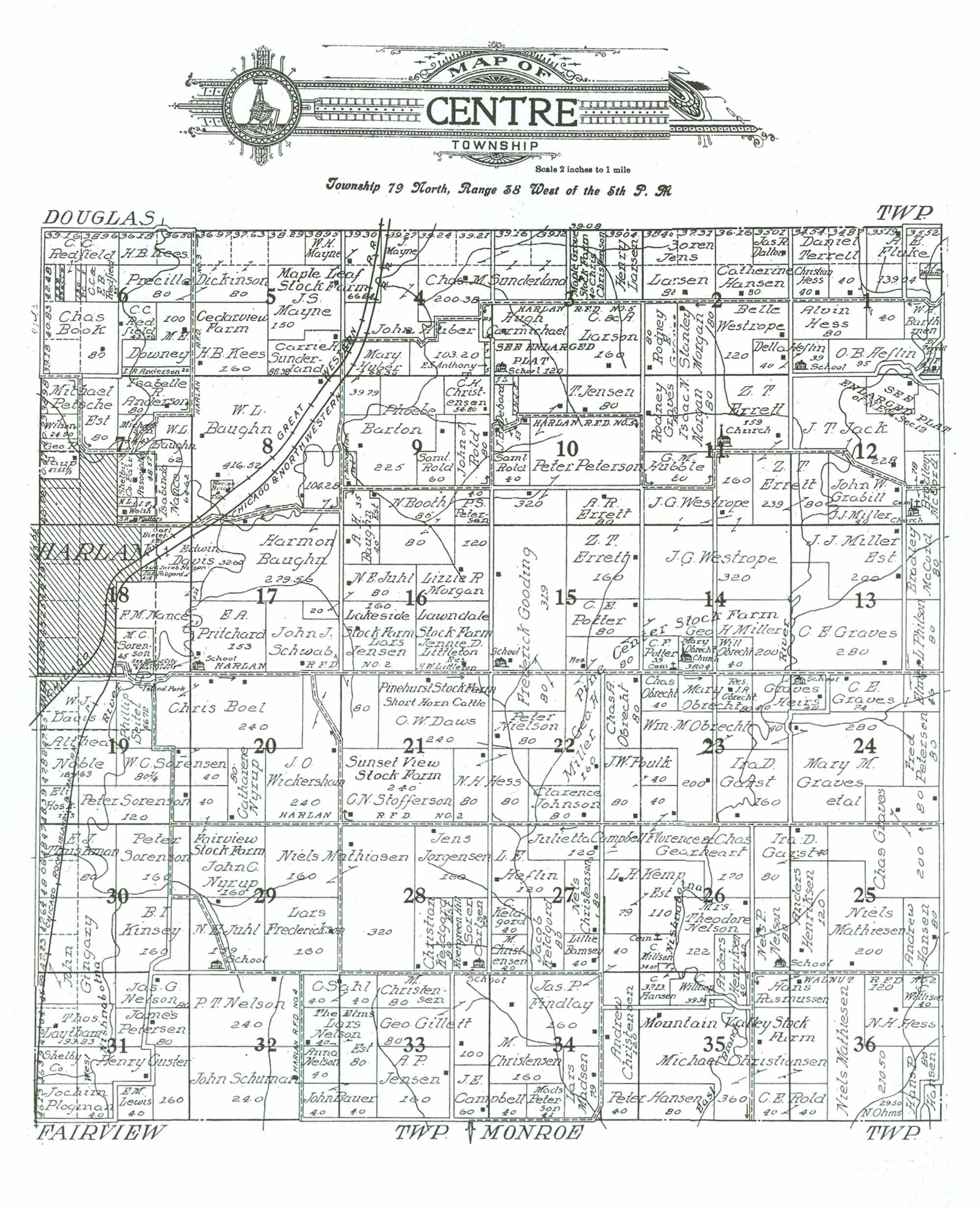 1911 CENTRE TOWNSHIP RESIDENTS
|
| LAST NAME | FIRST NAME | SECTION # | ACRES | COMMENTS |
|---|---|---|---|---|
| Anderson | I. A. | 6 | 20 | |
| Anderson | Isabelle A. | 7 | 80 | |
| Anthony | E. S. | 4 | 5 | |
| Bamsey | Lillie | 27 | 40 | |
| Barthman | W. H. | 1 | 0/40 | Estimated acreage; irregularly shaped |
| Barton | Phoebe | 9 | 225 | |
| Bauer | John | 32 | 40 | Owns add'l acreage in adjoining Section 33 |
| Bauer | John | 33 | 40 | Owns add'l acreage in adjoining Section 32 |
| Baughn | Harmon | 8 | 104.28 | |
| Baughn | Harmon | 17 | 279.56 | Add'l acreage in adjoining Section 8 |
| Baughn | W. L. | 7 | 62 | |
| Baughn | W. L. | 8 | 416.52 | Acreage in Section doesn't add up; possibly understate here by 100 acres-? |
| Baughn Est. | A. H. | 9 | 35 | Owns adjoining property in Section 16 |
| Baughn Est. | A. H. | 16 | 40 | Add'l acreage in adjoining Section 9 |
| Be(illegible) | J. F. | 1 | 0/12.5 | Name and acreage illegible; acreage estimated from Section total |
| Bie?er???? | Carl | 18 | 15.88 | Acreage estimated; difficult to read. Small parcel. |
| Boel | Chris | 19 | 80 | Acreage estimated; NE corner excluded-? |
| Boel | Chris | 20 | 240 | |
| Book | Chas. | 6 | 80/160 | Map shows parcel of 80 acres; appears to be more like 160 |
| Booth | N. | 9 | 85 | Owns adjoining property in Section 16 |
| Booth | N. | 16 | 80 | Add'l acreage in adjoining Section 9 |
| C. | P. | 6 | 5 | Property shows initials only of P.C. (?) and the "5" acres notation; name unknown |
| Campbell | J. E. | 33 | 60 | Owns add'l acreage in adjoining Section 34 |
| Campbell | J. E. | 34 | 40 | Owns add'l acreage in adjoining Section 33 |
| Campbell | Julietta | 27 | 120 | |
| Carlsen | Soren | 28 | 79 | "Evergreen Hill." "School" noted on property map; remaining 1 acre of Section dedicated to it? |
| Carmichael | Hugh | 3 | 120 | |
| Carmichael | Hugh | 4 | 22.5 | |
| Cemetery | 14 | 1 | Estimated from Section total | |
| Cemetery | 26 | 1.93 | Acreage estimated from Section total | |
| Christensen | Andrew | 34 | 120 | |
| Christensen | C. H. | 9 | 54.8 | |
| Christensen | M. | 27 | 40 | |
| Christensen | M. | 33 | 80 | |
| Christensen | M. | 34 | 160 | |
| Christenson | Chris | 3 | 40/80 | "Maple Grove Stock Farm" Acreage shown as 40; actually should be 80 |
| Christenson | Nels | 27 | 80 | |
| Christiansen | Michael | 35 | 360 | "Mountain Valley Stock Farm" Owns add'l acreage in adjoining Section 36 |
| Christiansen | Michael | 36 | 80 | Owns add'l acreage in adjoining Section 35; "Mountain Valley Stock Farm" |
| Church | 11 | 1 | Acreage estimated from Z. T. Errett's quarter-Section | |
| Church | 14 | 1.96 | Estimated from Section total; reflected on parcel owned by Mary Obrecht | |
| Church/cemetery | 12 | 1 | Reflected on property owned by Bradley McCord | |
| Custer | Henry | 31 | 160 | |
| Dalton | Jas. R. | 2 | 0/40 | |
| Davis | Edwin | 17 | 32.6 | Irregularly shaped parcel; owns acreage in adjoining Section 18 |
| Davis | Edwin | 18 | 60 | Acreage estimated |
| Davis | W. J. | 19 | 120 | Acreage estimated. |
| Daws | C. W. | 21 | 240 | "Pinehurst Stock Farm Short Horn Cattle" |
| Debord | J. B. | 10 | 53 | |
| Dickinson | Precilla | 5 | 80/160 | Owns adjoining acreage in Section 6 |
| Dickinson | Precilla | 6 | 80 | Owns adjoining acreage in Section 5 |
| Downey | M. E. | 6 | 100 | |
| Erreth | Z. T. | 15 | 160 | |
| Errett | A. R. | 10 | 80 | |
| Errett | Z. T. | 11 | 159 | Church indicated on property; allocated remaining 1 acre? |
| Errett | Z. T. | 11 | 239/80 | Acreage on map shows 239; includes 159 from second parcel. This parcel should reflect 80. |
| Errett | Z. T. | 12 | 80 | |
| Findlay | Jas. P. | 27 | 40 | Owns add'l acreage in adjoining Section 34 |
| Findlay | Jas. P. | 34 | 160 | Owns add'l acreage in adjoining Section 26 |
| Fluke | A. E. | 1 | 139.04 | |
| Frederickson | Lars | 29 | 160 | |
| Garst | Ira D. | 23 | 160 | Owns add'l acreage in adjoining Sections 26 and 25 |
| Garst | Ira D. | 25 | 40 | Owns add'l acreage in adjoining Sections 23 and 26 |
| Garst | Ira D. | 26 | 80 | Owns add'l property in adjoining Sections 25 and 23 |
| Gearheart | Florence & Chas. | 23 | 40 | Owns add'l acreage in adjoining Section 26 |
| Gearheart | Florence & Chas. | 26 | 170 | Own add'l acreage in adjoining Section 23 |
| Gillett | Geo. | 33 | 180 | |
| Gingary | John | 30 | 120 | Owns add'l acreage in adjoining Section 31 |
| Gingary | John | 31 | 80 | Owns add'l acreage in adjoining Section 30 |
| Gooding | Frederick | 15 | 319 | Add'l acreage in adjoining Section 22; 1 acre to "School" indicated on map-? |
| Gooding | Frederick | 22 | 80 | Owns add'l acreage in adjoining Section 15 |
| Gra(illegible) | Rodney E. | 2 | 80 | Last name partially covered; illegible |
| Grabill | John W. | 12 | (?) | Irregularly shaped parcel without acreage noted on map ; estimated between 100 - 120-? |
| Graves | C. E. | 13 | 280 | |
| Graves | C. E. | 24 | 74 | Owns add'l acreage in adjoining Section 13 |
| Graves | Chas. | 25 | 200 | Owns add'l acreage in adjoining Section 24 |
| Graves | Chas. | 24 | 80 | Owns add'l acreage in adjoining Section 25 |
| Graves | Heirs | 23 | 40 | |
| Graves | Heirs | 24 | 40 | Owns acreage in adjoining Section 23; "School" on property |
| Graves | Mary M. | 23 | 40 | Owns add'l acreage in adjoining Section 24 |
| Graves | Rodney | 11 | 80 | |
| Graves et al. | Mary M. | 24 | 280 | Map reflects 280 acres; area appears to be more like 320 acres |
| Hansen | Andrew | 25 | 80 | |
| Hansen | C. | 35 | 32.13/40 | Owns add'l acreage in adjoining Section 26; map shows 32.13 acres; should be closer to 40? |
| Hansen | C. | 26 | 5 | Owns add'l acreage in adjoining Section 35 |
| Hansen | Catherine | 2 | 80/120 | Acreage shown as 80; appears to be actually 120-? |
| Hansen | Hans P. | 36 | 80 | |
| Hansen | Peter | 34 | 40 | Owns add'l acreage in adjoining Section 35 |
| Hansen | Peter | 35 | 80 | Owns add'l acreage in adjoining Section 34 |
| Harlan (Municipality) | 7 | 135 | Acreage estimated | |
| Harlan (Municipality) | 18 | 340 | Acreage estimated | |
| Harlan (Municipality) | 18 | 3 | Acreage estimated; "See Map of City of Harlan for small parcel." "Island Park" | |
| Harlan (Municipality) | 19 | 2 | Acreage estimated, "See Map of City of Harlan for small parcel." "Island Park" | |
| Harlan Brick & T. G. | 8 | 20 (?) | Unable to read/determine acreage; estimated at 20 | |
| Heflin | Della | 1 | 39 | "School" noted; assumed 1 acre appropriated to it; owns prop. in Section 2 also |
| Heflin | Della | 2 | 40 | Owns adjoining acreage in Section 1 |
| Heflin | L. E. | 27 | 120 | |
| Heflin | O. B. | 1 | 95 | |
| Henriksen | Anders | 25 | 120 | |
| Henriksen | Anders | 26 | 40 | Owns add'l acreage in adjoining Section 35 |
| Henriksen | Anders | 35 | 40 | Owns add'l acreage in adjoining Section 26 |
| Hess | Alvin | 1 | 80 | |
| Hess | Christian | 1 | 40 | |
| Hess | N. H. | 21 | 80 | Owns add'l acreage in adjoining Section 22 |
| Hess | N. H. | 22 | 80 | Owns add'l acreage in adjoining Section 21 |
| Hess | N. H. | 36 | 120 | |
| Hoskins | Eli | 19 | 40 | |
| Hubble | G. M. | 11 | 80 | |
| Huber | John | 4 | 103.2 | |
| Huber | Mary | 4 | 68.3 | Acreage shown is best guess of number: difficult to read; owns adj. prop. in Section 9 |
| Huber | Mary | 9 | 39.79 | Owns adjoining property in Section 4 |
| Huber | John | 4 | 0/115.62 | Acreage unknown; estimated from remainder of Section total |
| Jack | J. T. | 12 | 228 | |
| Jensen | A. P. | 33 | 160 | |
| Jensen | Lars | 16 | 160 | "Lakeside Stock Farm" |
| Jensen | T. | 10 | 80 | |
| Johnson | Clarence | 22 | 80 | |
| Jorgensen | Jens | 28 | 160 | |
| Juhl | N. E. | 16 | 80 | |
| Juhl | N. E. | 17 | 20 | Add'l acreage in adjoining Section 16 |
| Juhl | N. E. | 29 | 159 | "School" noted on property map; remaining 1 acre for Section total dedicated to it? |
| Kees | H. B. | 5 | 160 | "Cedarview Farm" |
| Kees | H. B. | 6 | 0/80 | |
| Keldgord | C. | 27 | 40 | |
| Keldgord | Jacob | 27 | 80 | |
| Keldgord Est. | Christian | 28 | 80 | |
| Kemp Est. | L. H. | 26 | 110 | Owns add'l acreage in adjoining Section 27 |
| Kemp Est. | L. H. | 27 | 79 | Owns add'l acreage in adjoining Section 26 |
| Kinsey | B. I. | 30 | 160 | |
| L. | N. | 7 | 5 | Property shows initials only of N.L. and the "5" acres notation; name unknown |
| Larsen | (?)oren Jens | 2 | 80/160 | Acreage shown as 80; appoears to be acutally 160-? |
| Larsen | Henry | 3 | 80 | |
| Larson | C. (illegible) A. | 3 | 160 | |
| Laytham | Thos. | 31 | 93.23/80 | Map indicates 93.23 acres; appears to be more like 80 |
| Lewis | E. M. | 31 | 40 | |
| Littleton | Jennie D. | 16 | 160 | "Lawndale Stock Farm" |
| Madsen | Lars | 34 | 79 | |
| Mathiasen | Niels | 28 | 320 | Owns add'l acreage in adjoining Section 29 |
| Mathiasen | Niels | 29 | 160 | Owns add'l acreage in adjoining Section 28 |
| Mathiesen | Niels | 25 | 200 | |
| Mathiesen | Niels | 36 | 210.5 | |
| Mayne | J. | 4 | 40 | |
| Mayne | J. S. | 4 | 0/40 | |
| Mayne | J. S. | 4 | 40 | Owns adjoining acreage in Section 5 |
| Mayne | J. S. | 5 | 150 | "Maple Leaf Stock Farm" Owns adjoining acreage is Section 4 |
| Mayne | W. H. | 5 | 0/40 | |
| McCord | Bradley | 12 | 79 | One acre allotted to Church & cemetery indicated on property-? Add'l acreage in adj. sec. 13 |
| McCord | Bradley | 13 | 80 | Add'l acreage in adjoining section 12 |
| Michaelson | J. | 7 | 43 | |
| Miller | Geo. H. | 14 | 200 | Add'l acreage in adjoining sections 22 and 15; "Pine Center Stock Farm" |
| Miller | Geo. H. | 22 | 160 | Owns add'l acreage in adjoining Sections 15 and 14; "Pine Center Stock Farm" |
| Miller | Geo. H. | 15 | 80 | Owns add'l acreage in Sections 14 and 22; "Pine Center Stock Farm" |
| Miller | J. J. | 12 | 40 | |
| Miller Est. | J. J. | 13 | 200 | Add'l acreage in adjoining section 12 |
| Morgan | Isaac N. | 11 | 80 | |
| Morgan | Lizzie R. | 16 | 120 | |
| Morgan | Stanley | 2 | 80 | |
| Nance | F. M. | 17 | 10.28 | Unsure of acreage; difficult to read. Small parcel. |
| Nance | F. M. | 18 | 120 | Acreage estimated |
| Nance | Isabinda | 7 | 64.62 | |
| Nelson | Anna | 32 | 40 | |
| Nelson | Jacob | 18 | 2 | Acreage estimated; difficult to read. Small parcel. |
| Nelson | Jas. G. | 31 | 80 | |
| Nelson | Mrs. Theodore | 26 | 122 | |
| Nelson | Nels P. | 26 | 80 | "School" located on property |
| Nelson | P. T. | 32 | 240 | |
| Nelson Est. | Lars | 32 | 40 | Owns add'l acreage in Section 33; "The Elms" |
| Nelson Est. | Lars | 33 | 80 | Owns add'l acreage in adjoining Section 32; "The Elms" |
| Nicholson (?) | C. | 9 | 20.41 | Name difficult to read; may not be Nicholson. Acreage estimated from Section total |
| Nielson | Peter | 22 | 80 | |
| Noble | Althea | 19 | 140/187.63 | Acreage estimated: written notation shows 187.63 (?); appears to be more like 140 |
| Nyrup | Catharene | 20 | 80 | |
| Nyrup | John C. | 20 | 40 | Own's add'l acreage in adjoining Section 29; "Fairview Stock Farm" |
| Nyrup | John C. | 29 | 160 | "Fairview Stock Farm" Owns add'l acreage in adjoining Section 20 |
| O. | L. B. | 6 | 5 | Property shows initials only of L.B.O. (?) and the "5" acres notation; name unknown |
| Obrecht | Chas. | 23 | 40 | Owns add'l acreage in adjoining Section 22 |
| Obrecht | Chas. A. | 22 | 80 | Owns add'l acreage in adjoining Sections 23 |
| Obrecht | Mary | 14 | 38.04 | Add'l 1.96 acres to "Church" indicated on property-? |
| Obrecht | Mary | 23 | 80 | Property houses residence of J. A. Obrecht |
| Obrecht | Will | 14 | 40 | |
| Obrecht | Wm. M. | 23 | 200 | |
| Ohms | N. | 36 | 29.5 | |
| Patters | S. A. | 7 | 4 | Small parcel on south end of Section; unable to read/determine acreage |
| Paup | Geo. P. | 7 | 47.55 | |
| Petersen | Fred | 24 | 80 | |
| Petersen | James | 31 | 80 | |
| Petersen | P. S. | 9 | 40 | |
| Petersen | Peter | 10 | 320/387 | Map indicates 320 acres; appears to be more like 387-? |
| Peterson | Mads | 34 | 41 | |
| Petsche Est. | Michael | 7 | 80/120 | Map indicates 80 acres; appears to be more like 120 |
| Philson | Elmer L. | 13 | 80 | Add'l acreage in adjoining section 24 |
| Philson | Elmer L. | 24 | 46 | Owns add'l acreage in adjoining Section 13 |
| Plagman | Jochim | 31 | 40/80 | Map indicates 40 acres; appears to be more like 80 |
| Potter | C. E. | 15 | 80 | |
| Potter | C. F. | 14 | 39 | Add'l 1 acre designated to "Cemetery" indicated on map-? |
| Miller | Geo. H. | 15 | 80 | Add'l acreage in adjoining Sections 14 and 22 |
| Poulk | J. W. | 22 | 80 | Owns add'l acreage in adjoining Section 23 |
| Poulk | J. W. | 23 | 40 | Owns add'l acreage in adjoining Section 22 |
| Pritchard | E. A. | 17 | 153 | School on irregularly-shaped property; unknown how much acreage was designated to it. |
| Pritchard | E. A. | 18 | 50 | Acreage estimated; owns add'l acreage in adjoining Section 17 |
| Rasmussen | Hans | 35 | 40 | Owns add'l acreage in adjoining Section 36 |
| Rasmussen | Hans | 36 | 40 | Owns add'l acreage in adjoining Section 35 |
| Redfield | C. C. | 6 | 111.5 | Acreage approximated; unable to read record |
| Redfield | C. C. | 6 | 43.5 | |
| Redfield | C.C. & E. B. | 6 | 35 | |
| Risgard (?) | Jas. (?) | 18 | 4.12 | Acreage estimated; difficult to read. Small parcel. |
| Rold | C. E. | 35 | 40 | Owns add'l acreage in adjoining Section 36 |
| Rold | C. E. | 36 | 40 | Owns add'l adcreage in adjoining Section 35 |
| Rold | John J. | 9 | 80 | |
| Rold | Saml. | 9 | 60 | |
| Rold | Saml. | 10 | 40 | |
| Sahl | C. | 32 | 40 | Owns add'l acreage in Section 33 |
| Sahl | C. | 33 | 40 | Owns add'l adreage in adjoining Section 32 |
| School | 1 | 1 | Acreage estimated; reflected on acreage of Della Heflin | |
| School | 3 | 1 | Acreage estimated; notation on map: "See Enlarged Plat;" Unknown owner of parcel | |
| School | 17 | 1 | Acreage estimated; reflected on parcel owned by E. A. Pritchard | |
| School | 28 | 1 | Acreage estimated from Section total; reflected on parcel owned by Soren Carlsen | |
| School | 29 | 1 | Acreage estimated; reflected onproperty owned by N. E. Juhl | |
| Schuman | John | 32 | 240 | |
| Schwab | John J. | 17 | 140 | Acreage estimated; owns add'l acreage in adjoining Section 21 |
| Schwab | John J. | 21 | 80 | Owns add'l acreage in adjoining Section 17 |
| Seitel | Phillip | 19 | 56.72 | |
| Shelby Co. | 31 | 40 | ||
| Shelby Co. Fair Assoc. | 7 | 48.57 | ||
| Sorenson | M. C. | 18 | 45 | |
| Sorenson | Peter | 30 | 160 | Owns add'l acreage in adjoining Section 19 |
| Sorenson | W. C. | 19 | 80.5 | Owns add'l acreage in adjoining Section 20 |
| Sorenson | W. C. | 20 | 40 | Owns add'l acreage in ajoining Section 19 |
| Sorenson | Peter | 19 | 120 | Owns add'l acreage in adjoining Section 30 |
| Stofferson | C. N. | 21 | 240 | "Sunset View Stock Farm" |
| Sunderland | Carrie H. | 5 | 88.38 | |
| Sunderland | Chas. M. | 3 | 160 | Owns adjoining acreage in Section 4 |
| Sunderland | Chas. M. | 4 | 200.38 | Owns adjoining acreage in Section 3 |
| Terrell | D. | 1 | 12.5 | Acreage illegible; estimated from Section total |
| Terrell | Daniel | 1 | 40/120 | Map indicates 40 acres; appears to be 120 |
| Terrell | Daniel | 1 | 40 | |
| Thuskman (?) | E. J. | 30 | 80/120 | Maps indicates 80 acres; appears to be 120. |
| Unknown | 4 | 5 | Owners name not provided | |
| Unknown | 5 | 41.62 | No name provided; acreage estimated from remainder of Section total | |
| Unknown | 12 | (?) | Map indicates "See Enlarged plat of NE Sec. 12." (Not provided) | |
| Unknown | 12 | (?) | Map indicates "See Enlarged plat of NE Sec. 12." (Not provided) | |
| Unknown | 30 | 80 | Parcels owners not indicated | |
| Unknown | 3 | 39 | "School" noted on parcel; name of parcel owner not given. | |
| Weland (?) | J. J. | 1 | 20.96 | Acreage not stated; estimated from Section total |
| Welsh | I. T. (?) | 7 | 6 | Small parcel; unable to read/determine acreage |
| Westrope | Belle | 2 | 120 | |
| Westrope | J. G. | 11 | 160 | Owns adjoining property in Section 14 |
| Westrope | J. G. | 14 | 320 | |
| Wickershcun | J. O. | 20 | 240 | |
| Willison | C. | 35 | 39.36 | |
| Willison | C. | 36 | 40 | |
| Willson | C. | 26 | 31.07 | Acreage estimated; difficult to read. Cemetery noted on parcel. Name should be Willison? |
| Wilson | J. | 7 | 24.9 |
Transcribed by Denise Wurner, November, 2012.
Please notify the Shelby Coordinator of any transcription errors.