

Active Appanoose Coal Mines as of 1913
From Past and Present of Appanoose County, Iowa. Volume I
Chicago: The S.J. Clarke Publishing Company. L.L. Taylor, editor. 1913
A complete copy of this book is available on-line at archive.org.
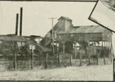
Shawville Mine
It is stated that the first coal shaft ever sunk in the country was by B. F. Kindig, who found the coal bed about sixteen feet below the limestone rock which crops out in the vicinity. This was in 1863 or 1864, but coal had been known to exist in the county long before, for it crops out in several places along Shoal Creek and its tributaries, and had been mined for several years for local uses.
The shaft of the Appanoose Coal Company, near the railway junction at Centerville, was sunk, it is said, twenty or thirty feet below where the coal was afterward found. An experienced miner suggested that a side drift be made at a depth of one hundred and twenty feet. The experiment was tried, and the coal was found a few feet from the shaft. Other shafts have been sunk below where the coal ought to lie, and trunks of trees, buried in clay, have been found, indicating that the coal has, since its formation, been gashed and broken by some disturbing cause. This would seem to have been a local upheaval, for the reason that the limestone overlying the coal, lying west and south of Centerville, has a positive dip toward the southwest of perhaps fifteen degrees, which can be ascertained by visiting the mine owned by Mr. Kindig, and that worked by Mr. McClard. Further, the coal bed itself dips at the same angle. The bed probably does not possess this dip for any great distance, for, as stated above, it appears near water mark along Shoal creek, and along the streams in the northwest part of the county. The line of disturbance or breakage then passes nearly north and south in the vicinity of Centerville.
The following is given as the order in which the rocks were found in sinking the shaft of Oliver, Phillips & Dargaval's mine, in the eastern part of Centerville about the year 1875, after passing through the surface of soil and clay: Hard lime-rock, 8 feet ; soapstone ; hard sand-rock, 2 feet ; soapstone ; limestone, nearly 4 feet ; soapstone ; limestone, 1 foot ; soapstone ; "black rock" or shale, 2 feet ; coal. The sand-rock appears between two layers of lime-rock, in the ledge near Talbot's mill, on Cooper creek, but the soapstone is wanting, having apparently thinned out or been dissolved away by the action of water. The rock near Talbot's is filled with fossils from top to bottom, all apparently of the same species.
The shaft of the Watson Coal Company, a short distance south of the Rock Island depot, is stated to have shown the following stratifications: Soil, clay and gravel, 80 feet; hard lime-rock, laying in layers and broken by joints, 12 feet: shale and soapstone, 8 feet; fossil-bearing (mountain) limestone. 9 feet; black slate, 15 feet; lime-rock, 3 feet; shale, 16 feet; lime-rock, 3 feet; slate 4 feet; lime-rock, 6 feet; coal, 3 feet. It may be noticed as a curious circumstance that the sand bed in the Oliver mine and at Talbot's Mill is wanting in the Watson mine. However, as many layers are entirely wanting in the Iowa coal system which are noticed elsewhere, these local variations may be expected.
In some places in the western part of the county, a thin layer of coal or shale has been noticed, which goes to show that the Upper Carboniferous touches Appanoose on the west. The group of rocks covering the coal belong to the "mountain limestone," as named by Dana and sanctioned by Lyell.
The coal industry of Appanoose county has reached vast proportions in the past few years, as the products of over fifty mines will attest. In the year ending December 11, 1911, there were taken from the bowels of the earth in this county, one and one-third millions tons of coal, which meant the employment of over three thousand men and a vast expenditure of money for labor and working material. Most if not all, of the money was spent in the county and as a consequence, the operating of the mines has increased the wealth of the county to a very appreciable extent. From the fact that the lands of Appanoose county are teeming with coal, - rich and deep veins of the black diamond of a splendid quality, - the owners of these lands, many of them, have become enriched from royalties received on the coal mined and unmined and from the products of the soil. Appanoose coal finds a ready market and from shafts dotted here and there in different parts of the county comes a steady stream of the article that is shipped broadcast over the land.
A list of the mines now operating in the county follows:
Transcribed by Renee Rimmert