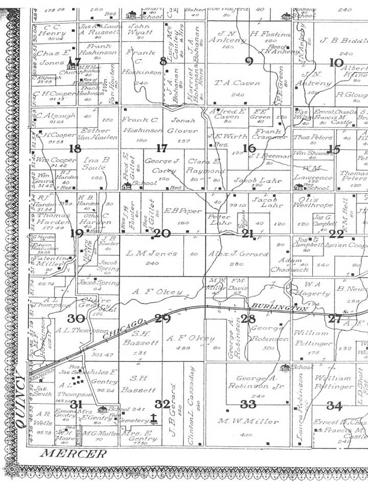
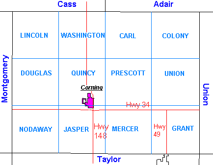
Description of Townships of Adams County Iowa
Hover over image to zoom in and out, left and right arrow to go to next page
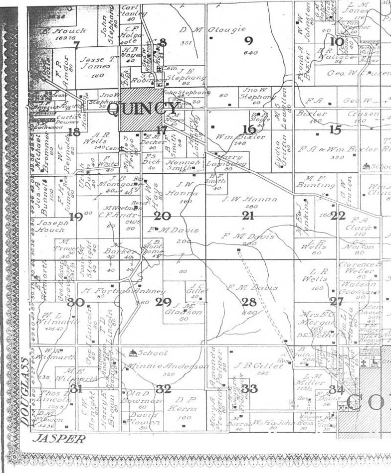
The following 1912 map images were copied from a county atlas, published in 1912. This atlas is in the Corning Public Library, Corning, Iowa.
Maps:
Description of Townships of Adams County Iowa
According to the 1984 Adams County History Book, on March 12, 1853, "the county began its legal existance under authority of the Legislature of Iowa, for the purpose, at which time its territory was composed of 36 congressional townships, including the present counties of Union and Montgomery. This territory was divided into three civil townships, the settlers of Union Township voting at the Mormon cabins, called Pisgah, and those of Montgomery Township voting at the cabin of Amos Lowe on the Nishna-botna, while those of Quincy Township, comprising Adams County, voted at the house of Samuel Baker, in the cabin still standing (in 1890) on the Lewis J. Jeffrey estate in Douglas Township."
"Union County organized for itself after a partnership of 30 days, and Montgomery set up a local organization in 1854, leaving Adams with 12 congressional townships."
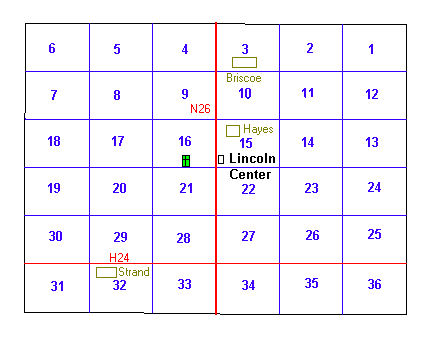
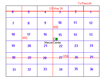
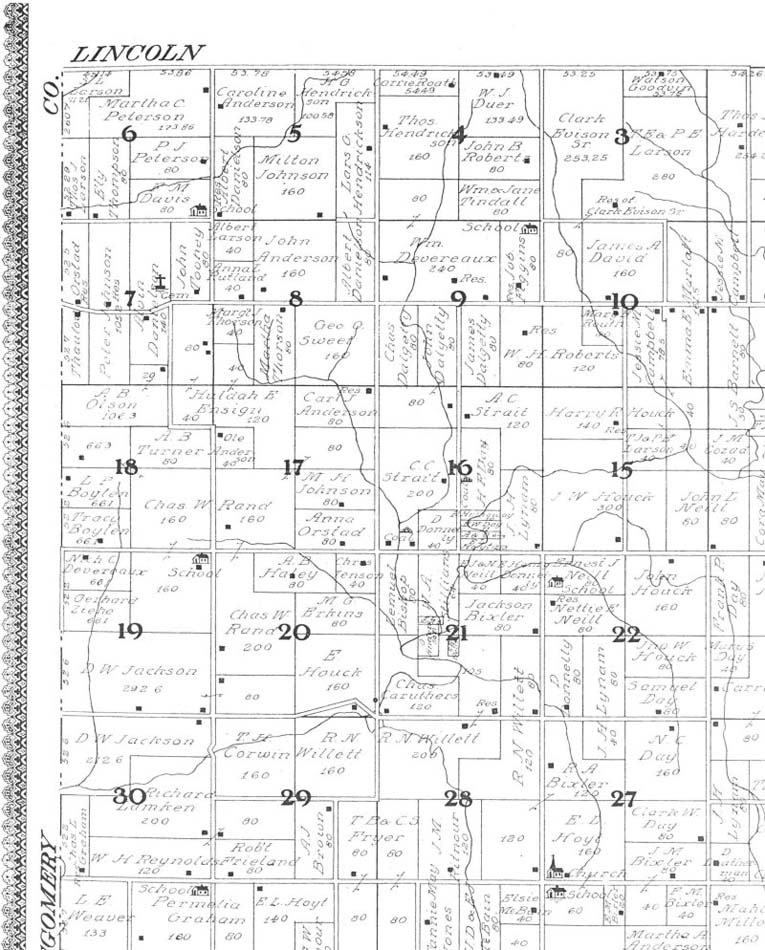
LINCOLN TWP.
Lincoln Center Methodist Church, near the center of Lincoln Twp., was organized in 1870 by Rev. Wm. T. Smith. The church was organized in a school house that stood in what is now Lincoln Center cemetery. In 1878 a new school house was built one half mile east of the cemetery, on a lot where the Lincoln Center school house now stands. Church and Sunday School were held there until the present church building was erected, in the fall of 1890.
In the 1890's S.F. Davis built a general store one fourth mile north of Lincoln Center. A Post Office was put in the store and the community was named Hayes. On the second story of the store the lodges of the Woodman of the World and Modern Woodman held regular meetings for years.
The groceries and mail was brought from the town of Cumberland by a Star Route mail service to both Briscoe and Hayes. Mr. Charles Seaman was the mail carrier. Mrs. Davis operated a telephone switchboard with several party lines from a house just north of the store. Just north of the Davis house Charles Sullivan put up a blacksmith shop. North of Lincoln Center one half mile, Henry Fleharty operated a cheese factory.
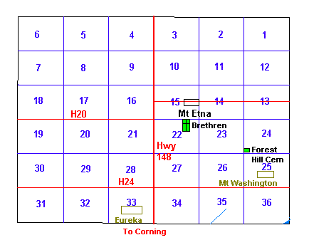
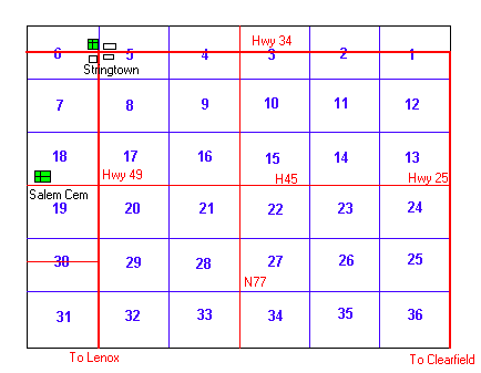
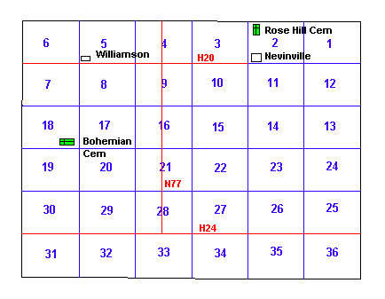
In March 1853, Adams County was organized and most of the area was included in Quincy Township. But in 1858 a separate section was organized and named Washington Township. During this interval, the US Government, on July 1, 1854, granted to Levi Prickett a claim to the land that was to become Mount Etna. He sold it on Feb 10, 1855 for $140 to Isaiah Fees. Mount Etna officially became a place on October 14, 1856. Robert Mansfield named it, but we don't know why he called it Mt. Etna.
The Fees family, the Schoolings, the Abraham Thomas family, the Gideon Farris family, and Morgan family were among the first settlers in Washington Township, having arrived around 1850-1852. John Fees and Jacob Fees were among the thirteen registered voters who voted at Quincy in 1853. Other early settlers in this township include: H.C. Ankeny, Isaac Poston, A.L. Wells, E.Y. Burgan, Clark D. Lawrence, J.R. Holbrook, and Phelix Schooling. As early as 1851 there were settlers in Washington Twp: the John Sprague family settled southeast of Mt. Etna, the Morgan Warren family settled just east of Mt. Etna, the Adam Poor family settled near Eureka, the Parson family settled at Eureka. However, because of the Indian raids, many returned to Burlington for a time. It is said that within a year most of them had returned to their empty cabins and had become permanent settlers in or near Mt. Etna. In the fall of 1852 the first white child was born in Washington Township; a son, Scott Warren, was born to the Morgan Warrens.
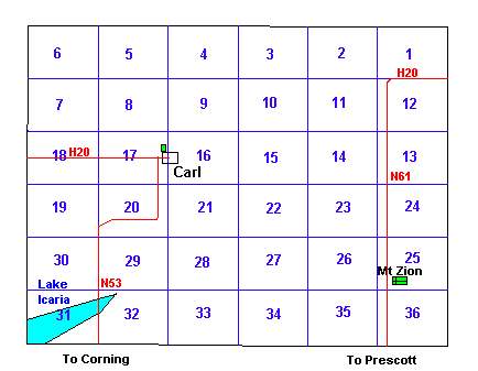
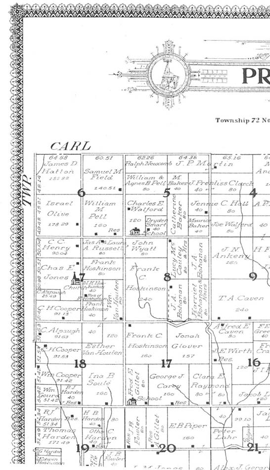
The first settlers in Carl twp. were Mr. and Mrs. Jephtah Robinson in about 1856. The town, Carl, was named after their first child. The Robinsons ran a general store and post office in Carl. The post office operated from August 24, 1858 to Jan 2, 1907. Other owners of this store were Frank Davis, Cash Fees, Sam Kirkpatrick, Leon Antisdel, Junior Antisdel, and Alfred Krisinger. Another store on the north side of town was owned by Bert Harlow, Charles Drake, Ben Davenport, Creighton and Morrison, Pete Templeman and Pat Bennet. Ben Davenport and Everett Fees had a huckster wagon and delivered supplies to local farmers. Other stores included a blacksmith shop, livery stable, garage, hotel, creamery, barber shop, hatchery, and beauty parlor.
The desire of Rev. Edwin H. Nevin, a pastor at Walpole, MA, to take his vacation in the summer of 1855 to the open territory beyond the Missouri River, led to the settlement of this New England colony in Iowa. Dr. Nevin was a passenger on the Wm Lock mail rig that ran weekly from Afton to the Adair and Lewis post offices. From Lewis he rode on the Concord coach line running from the Mississippi to the Missouri. He visited an Indian Mission school at Bellevue, NE and some new settlements in Kansas along with (slavery) conflicts in the Kansas territory.
After Dr. Nevin returned to his parish in Massachusetts, a business meeting was held to consider the question of planting a colony of New England people in southwestern Iowa. Promises of railroads, steamboats, schools and churches were told to these people. Roswell W. Turner and Richard B. Smith agreed to the idea of this colony. Dr. Nevin's name was given to this place, but he was not to put any money into this plan. Sixteen sections of land were purchased in southern Adair County and northern Adams County.
A small group of men left New England on April 16, 1856 for the promised land. In Illinois and Iowa, swollen streams and rains gave the travelers problems. Many wished to return home, but were persuaded to remain by the promise of 100 dollars each. A schoolhouse was built, but was damaged by a thunderstorm on July 4, 1857. A hotel was also built, called the New England House.
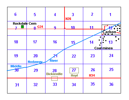
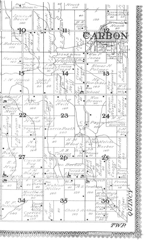
Elijah Walters was the first white man to settle in Adams County, in the year 1849. With his son Isaac, he built a saw mill on the Middle Nodaway River near the present site of Carbon. In June of 1853, he obtained the deed to this 40 acres from the land office in Kanesville (present day Cuncil Bluffs). On May 2, 1855, John Barnett became the first owner of the 40 acres adjacent on the east.
Adam Poor and Morgan Warren were early settlers coming shortly after the Walters, so, with three houses, the settlement was called Walter's Mill. In a few years they built a gristmill close to the saw mill to make meal. It was made of hewn oak timber. Samuel Hardisty helped in building the mill. In 1862, Thomas Nelson, by adding another story, turned it into a "flower mill" with the help of Sam Smith of Milford.
The mill was the first Post Office with William Cormack the first Postmaster. Sunday services and Sunday school were held in the mill, with Rev. Gaskel, Rev. Smith, and Rev. Hope the first pastors. Next to the mill was a stone building, one part used as a store and the other used as a school, with Miss Bell as teacher.
With the discovery of coal, more settlers located here and in 1870 a village sprang up named Carbon with the old mill as a background. In 1873 the plat of Carbon was made from land secured from John and Elizabeth Barnett and Thomas and Rebecca Nelson. Carbon was incorporated in 1904 with Knute Knudson as first Mayor.
Adams County was organized in the spring of 1853. At this time it encompassed 36 Congressional townships, or the present areas of Montgomery and Union counties as well as that of Adams. This arrangement was short-lived, however. Within a year, both Union and Montgomery 'townships' would pull away and form County goverments.
In 1853, Amos Lowe, the official charged with the organizing of the county, appointed a commision composed of a man from each of the counties - Taylor, Page and Mills, who were to choose the site of a County Seat. The Commision met and designated a quarter-section of Government land sprawled over the high ridgetop which lay betwixt and between Walters Creek and the Middle Nodaway.
The parcel was purchased by J.M.B. Miller, an early settler, with money furnished by Jesse Williams, a land speculator from Virginia. Adams County took title to half the lots after platting was completed. The others were divided equally between Williams and Miller.
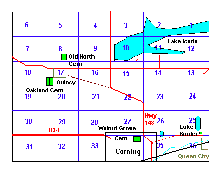
In a short time, the County was able to sell enough lots to finance the construction of a courthouse and one was built (in Quincy) at a cost of $545.00. This first courthouse burned the night that robbers set fire to Dr. Walker's office after leaving him for dead. The replacement building doubled as a courthouse and schoolhouse with classes held on the ground floor and the County Offices upstairs. After 1872 when Quincy was no longer the County Seat, the building still functioned as a schoolhouse until it was torn down in the 1920's or 1930's.
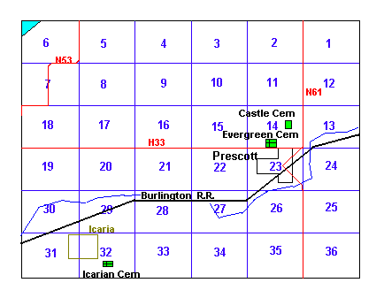
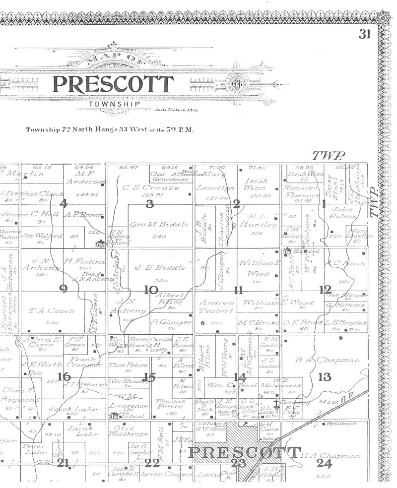
In 1846, when Iowa became a State, the area now known as Prescott was virgin timber with the Nodaway River to the south and a few natives roaming the area. A small 'Indian' burial ground is located a short distance to the south of town. With the building of the Burlington Northern Railroad (C, B & Q) in 1868, the settlement of Prescott then known as Motley and later Glendale, began to develop on the south side of the tracks. The name Prescott came about in 1869, in honor of one of the men instrumental in building the railroad. The railroad played an important part in the early life of Prescott, with its regular stops of passenger and freight trains. Until it was completed in 1869, everyone drove to Afton, some 30 miles away, for their supplies. The orginal plat of Prescott was recorded June 6, 1870.
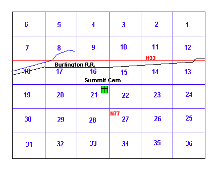
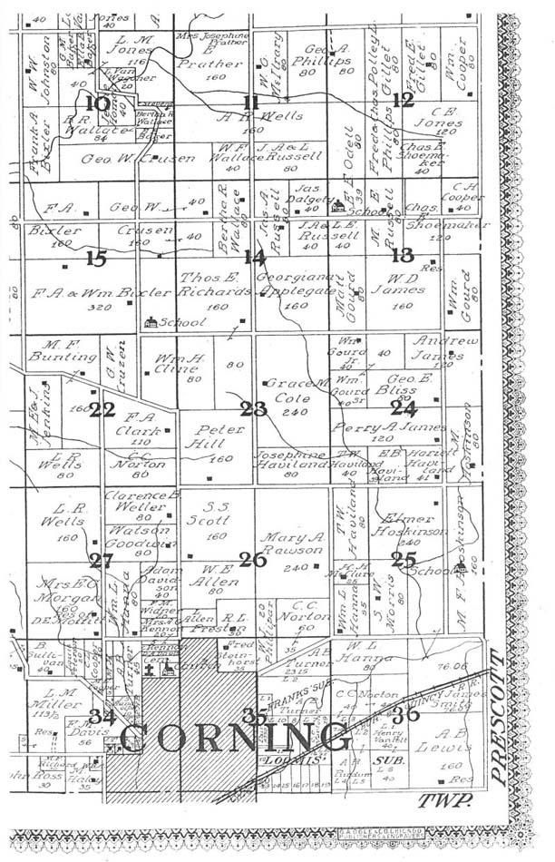
Union #5 or Union Center School is located in the center of Union Township. At one time the railroad passed not far from the north side of the schoolhouse. Those tracks were moved but the right-of-way is still in evidence. Railroad men thought the spot to be one of the highest, if not the highest on the line, so the name of Summit was given to the school and to the nearby cemetery.
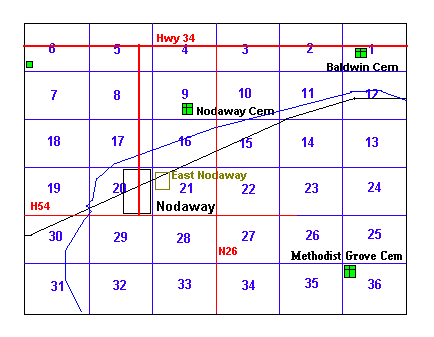
On June 2, 1854, the land which is now Nodaway was bought from the goverment by James Harlow. It was vigin soil, mostly timber. Early settlers living on the banks of the East Nodaway River decided their settlement needed a name. They appropriately called it "East Nodaway". During the 1870's a new name, "Rachelle", was adopted and recorded in Washington, D.C. The name proved so unpopular that within a year it was changed to "Nodaway", which was an Indian word meaning "Crossed without a canoe". Nodaway became incorporated as a town May 28, 1900.
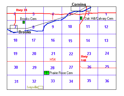
In 1853 and 1854 early settlers from the east settled in Adams County where Brooks is now located. Feeling they had found their "promised land", they named the settlement "Canaan City". Later in 1854, the town was conveyed by the government to Wm. Shield and became known as Brookville. In 1855 Mr. Shield conveyed the portion of the town to Silas Riggs, which is still known as the Riggs addition. There was inconvenience in the name of Brookville, due to another town in Jefferson County with the same name. Since the Methodist Church had started a seminary in the north end of town which was named Simpson in honor of the Bishop Simpson, the post office went by the name of Simpson in 1860. Mail was being sent to Simpson but the railroad was shipping to Brookville. Since the seminary had moved to Indianola, the post office and depot both took the name of Brooks in 1871 and kept it to this time.