|
|
Shelby County |

1911 UNION TOWNSHIP PLAT MAPClick on map to enlarge.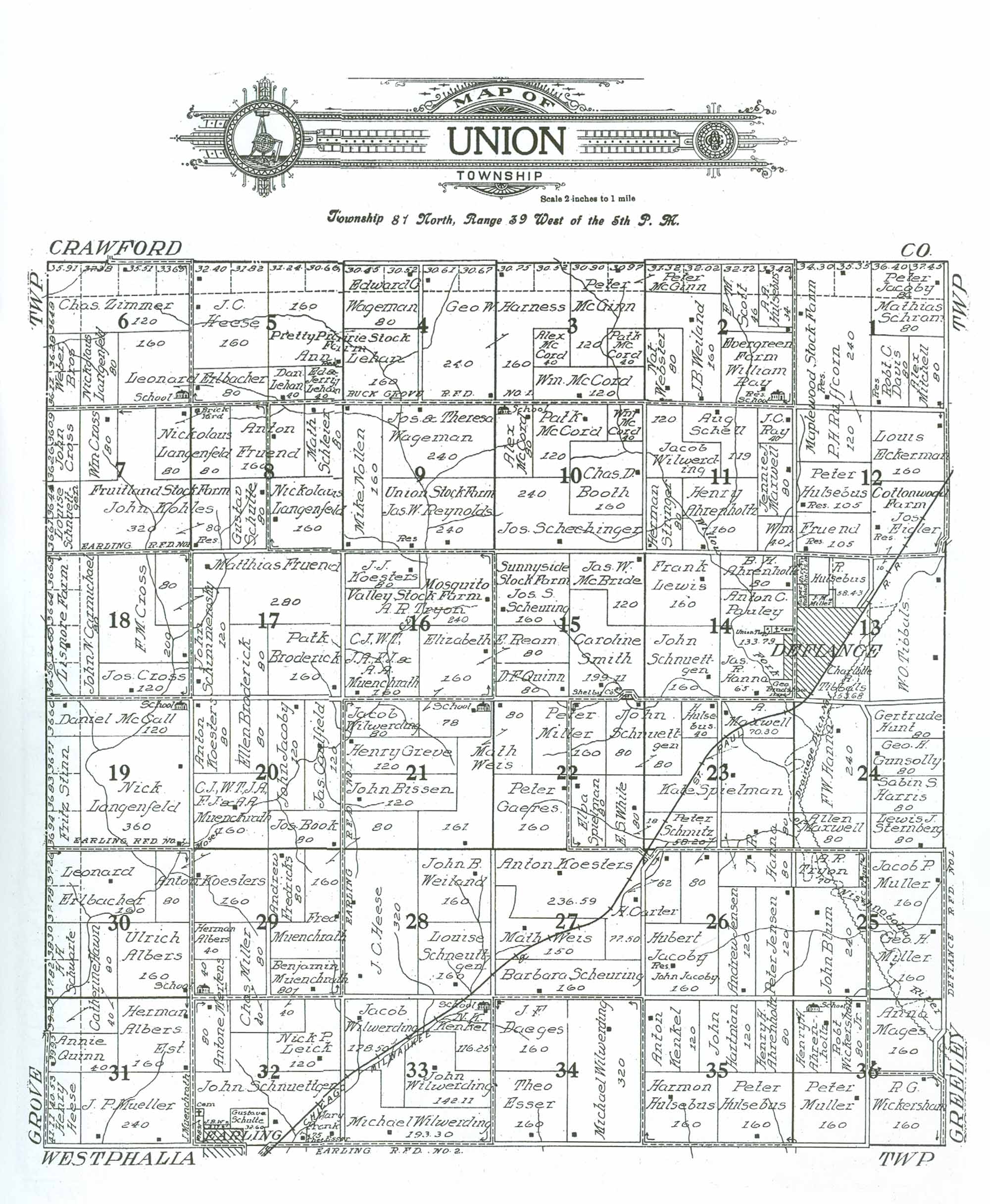 1911 UNION TOWNSHIP RESIDENTS
|
| LAST NAME | FIRST NAME | SECTION # | ACRES | COMMENTS |
|---|---|---|---|---|
| Ahrenholtz | (?) | 13 | 10 | Difficult to read; very small parcel in NW corner of Section; acreage estimated. |
| Ahrenholtz | (?) | 13 | 10 | Difficult to read; very small parcel in NW corner of Section; acreage estimated. |
| Ahrenholtz | B. H. | 14 | 80 | |
| Ahrenholtz | Henry | 11 | 160 | |
| Ahrenholtz | Henry H. | 35 | 80 | |
| Ahrenholtz | Henry H. | 36 | 80 | "School" located on northern border of property |
| Albers | Herman | 29 | 40 | |
| Albers | Ulrich | 30 | 160 | |
| Albers Est. | Herman | 31 | 160 | |
| Bissen | John | 21 | 120 | |
| Blum | John | 25 | 240 | |
| Book | Jos. | 20 | 80 | |
| Booth | Chas. D. | 10 | 160 | |
| Bradshaw | Geo. | 14 | 18 | Acreage estimated; difficult to read. |
| Broderick | Ellen | 17 | 80 | Owns adjoining property in Section 20 |
| Broderick | Ellen | 20 | 80 | Owns adjoining property in Section 17 |
| Broderick | Patk | 17 | 160 | |
| Carmichael | John N. | 18 | 80/226.39 | "Linsmore Farm" Map indicates 80 acres, actully more like 226.39 |
| Carter | H. | 26 | 62 | Owns adjoining property in Section 27 |
| Carter | H. | 27 | 77.5 | Owns adjoining property in Section 26 |
| Caulfield | Jas. | 20 | 120 | |
| Cemetery | 14 | 5 | Acreage estimated | |
| Cemetery | 32 | 2 | Acreage estimated; Located on western border of property owned by John Schnuettgen | |
| Cross | F. M. | 18 | 200 | |
| Cross | John | 7 | 72.35 | Acreage estimated. |
| Cross | Jos. | 18 | 120 | |
| Cross | Wm. | 7 | 80 | |
| Daeges | J. F. | 34 | 160 | |
| Davis | Robt. C. | 1 | 80 | |
| Defiance (Town/Municipality) | 13 | 106 | Acreage estimated | |
| Definance (Town/Municipality) | 14 | 16.21 | Acreage estimated. | |
| Earling (Town/Municipality) | 32 | 20 | Acreage estimated | |
| Eckerman | Louis | 12 | 160 | |
| Eicler | Jos. | 13 | 10 | Owns adjoining property in Section 12 |
| Eicler | Jos. | 12 | 160 | Owns adjoining property in Section 13 |
| Erlbacher | Leonard | 5 | 80 | Owns adjoining property in Section 6 |
| Erlbacher | Leonard | 6 | 160 | "School" located in SE corner of property |
| Erlbacher | Leonard | 30 | 160/235.04 | Map states 160 acres, is actually 235.04 |
| Esser | Theo | 32 | 7.5 | Small triangle of property located just west of Mary Frank's. Difficult to read name |
| Esser | Theo | 34 | 160 | |
| Frank | Mary | 32 | 30 | |
| Fredricks | Andrew | 29 | 80 | |
| Fruend | Anton | 8 | 160 | |
| Fruend | Matthias | 17 | 280 | |
| Fruend | Wm. | 11 | 40 | Owns adjoining property in Section 12 |
| Fruend | Wm. | 12 | 105 | Owns adjoining property in Section 11 |
| Gaeres | Peter | 22 | 160 | |
| Greve | Henry | 21 | 120 | |
| Gunsolly | Geo. H. | 24 | 80 | |
| Hanna | F. W. | 24 | 240 | |
| Hanna | J. R. | 23 | 80 | |
| Hanna | J. R. | 26 | 80 | Owns adjoining property in Section 23 |
| Hanna | Jas. R. | 14 | 65 | |
| Harness | Geo. W. | 3 | 160/221.27 | Map reflects 160 acres, is actually 221.27; Owns adjoining property in Section 4 |
| Harness | Geo. W. | 4 | 240/301.28 | Map indicates 240 acres, is actually 301.28; Owns adjoining property in Section 3 |
| Harris | Sabin S. | 24 | 80 | |
| Hartman | John | 35 | 120 | |
| Hawn | Catherine | 30 | 80 | |
| Hawn | Catherine | 31 | 40/79.37 | Map shows 40 acres, is actually 79.37 |
| Heese | Henry | 31 | 81.64 | |
| Heese | J. C. | 5 | 160/224.22 | Map reflects 160 acres, is actually 224.22 |
| Heese | J. C. | 28 | 320 | |
| Hulsebus | A. A. | 2 | 34/67.42 | Map reflects 34 acres, is actually 67.42 |
| Hulsebus | H. | 23 | 40 | |
| Hulsebus | Harmon | 35 | 160 | |
| Hulsebus | Kasper (?) | 13 | 10 | Difficult to read; very small parcel in NW corner of Section; acreage estimated. |
| Hulsebus | Peter | 12 | 105 | |
| Hulsebus | Peter | 35 | 160 | |
| Hulsebus | R. | 13 | 30 | Acreage estimated |
| Hulsebus | R. | 13 | 58.43 | |
| Hunt | Gertrude | 24 | 80 | |
| Jacoby | Hubert | 26 | 160 | Residence of John Jacoby located on property |
| Jacoby | John | 20 | 120 | |
| Jacoby | Peter | 1 | 80 | |
| Jensen | Andrew | 26 | 120 | |
| Jensen | Peter | 26 | 120 | |
| Kenkel | Anton | 35 | 120 | |
| Kenkel | N. K. | 33 | 116.25 | "School" located in NE corner of property |
| Koesters | Anton | 20 | 80 | |
| Koesters | Anton | 27 | 236.59 | |
| Koesters | Anton | 29 | 160 | Owns adjoining property in Section 30 |
| Koesters | Anton | 30 | 80 | Owns adjoining property in Section 29 |
| Koesters | J. J. | 16 | 80 | |
| Kohles | John | 7 | 320 | "Fruitland Stock Farm" Owns adjoining property in Section 8 |
| Kohles | John | 8 | 80 | "Fruitland Stock Farm" Owns adjoining property in Section 7 |
| Landenfeld | Nickolaus | 6 | 80 | |
| Landgenfeld | Nickolaus | 7 | 80 | Owns adjoining property in Section 8 |
| Langenfeld | Nick | 19 | 360 | |
| Langenfeld | Nickolaus | 8 | 80 | Owns adjoining property in Section 7 |
| Langenfeld | Nickolaus | 8 | 160 | |
| Lehan | Ann | 4 | 160 | "Pretty Prairie Stock Farm" Owns adjoining property in Section 5 |
| Lehan | Ann | 5 | 160/221.84 | Map reflects 160, actually 221.84 acres. "Pretty Prairie Stock Farm" Owns adjoining property in Section 4 |
| Lehan | Dan | 5 | 40 | |
| Lehan | Ed. & Jerry | 5 | 40 | |
| Leick | Nick P. | 32 | 120 | |
| Lewis | Frank | 14 | 160 | |
| Mages | Anna | 36 | 160 | |
| Maxwell | A. | 23 | 70.3 | |
| Maxwell | Allen | 24 | 80 | |
| Maxwell | Jennie J. | 11 | 80 | |
| McBride | Jas. W. | 15 | 120 | |
| McCall | Daniel | 19 | 120/156.60 | Map indicate 120 acres, is more like 156.60 |
| McCord | Alex | 3 | 40 | |
| McCord | Alex | 10 | 80 | "School" located in NW corner of property |
| McCord | Patk | 3 | 40 | |
| McCord | Patk | 10 | 120 | |
| McCord | Wm. | 3 | 120 | |
| McCord | Wm. | 10 | 40 | |
| McGinn | Peter | 2 | 63.34 | |
| McGinn | Peter | 3 | 120/181.87 | Map reflects 120 acres, actually 181.87 |
| Mertens | Antone | 29 | 40 | "School" located on SW corner of property; owns adjoiningn property in Section 32 |
| Mertens | Antone | 32 | 80 | Owns adjoining property in Section 29 |
| Miller | Chas. | 32 | 40 | Owns adjoining property in Section 29 |
| Miller | Chas. | 29 | 80 | |
| Miller | Geo. H. | 25 | 160 | |
| Miller | J. M. | 13 | 15 | Acreage estimated |
| Miller | Peter | 22 | 160 | |
| Mitchell | Alex | 1 | 80 | |
| Mueller | J. P. | 31 | 240 | |
| Muenschrath | Benjamin | 29 | 80 | Owns adjoining Property in Section 32 |
| Muenschrath | Benjamin | 32 | 40 | Owns adjacent property in Section 29 |
| Muenschrath | CJ, WT, JA, EJ & AA | 16 | 160 | |
| Muenschrath | CJ, WT, JA, EJ & AA | 20 | 160 | |
| Muenschrath | Fred | 21 | 80 | Owns adjacent property in Section 29 |
| Muenschrath | Fred | 29 | 160 | Owns adjacent property in Section 21 |
| Muenschrath | J. | 32 | 8.91 | Property just south of cemetery |
| Muller | Jacob P. | 25 | 160 | |
| Muller | Peter | 36 | 160 | |
| Nollen | Mike | 9 | 160 | |
| Pauley | Anton C. | 14 | 133.79 | "Cemetery" located on eastern border of property |
| Quinn | Annie | 31 | 40/79.95 | Map shows 40 acres, actually 79.35 |
| Quinn | D. F. | 15 | 80 | |
| Ray | J. C. | 11 | 40 | |
| Ray | William | 2 | 160 | "Evergreen Farm" "School" located in SE corner of property |
| Ream | Elizabeth E. | 15 | 80 | Owns adjoining property in Section 16 |
| Ream | Elizabeth E. | 16 | 160 | Owns adjoining property in Section 15 |
| Ream | Elizabeth E. | 21 | 78 | "School" located in NE corner of property, assume 1 acre allotted to it. |
| Reynolds | Jas. W. | 9 | 240 | |
| Ruffcorn | P. H. | 1 | 240/320 | "Maplewood Stock Farm" Owns adjoining property in Section 12; acreage total is 320, not 240 |
| Ruffcorn | P. H. | 12 | 120 | "Maplewood Stock Farm" Owns adjoining property in Section 1 |
| Schechinger | Jos. | 10 | 240 | |
| Schell | Aug | 11 | 119 | |
| Scheuring | Barbara | 27 | 160 | |
| Scheuring | Jos. S. | 15 | 160 | "Sunnyside Stock Farm" |
| Schimmerosky | John | 17 | 120 | Owns adjoining property in Section 18 |
| Schimmerosky | John | 18 | 80 | Owns adjoining property in Section 17 |
| Schleier | Math. | 8 | 80 | |
| Schmitz | Peter | 23 | 58.2 | Owns adjoining property in Section 26 |
| Schmitz | Peter | 26 | 80 | Owns adjoining property in Section 23 |
| Schneuttgen | Louise | 28 | 160 | |
| Schnuettgen | John | 14 | 160 | |
| Schnuettgen | John | 32 | 255 | Acreage estimated; "Cemetery" located on western border of property |
| Schnuettgen | Louise | 7 | 73.01 | Acreage estimated. |
| School | 2 | 0 | Located in SE corner of property owned by William Ray | |
| School | 6 | 0 | Located in SE corner of property owned by Leonard Erlbacher | |
| School | 10 | 0 | Located in NW corner of property owned by Alex McCord | |
| School | 21 | 1 | Located on NE corner of property owned by Elizabeth E. Ream | |
| School | 33 | 0 | Located in NE corner of property owned by N. K. Kenkel | |
| School | 36 | 0 | Located on northern border of property owned by Henry H. Ahrenholtz | |
| Schram | Mathias | 1 | 80 | |
| Schruettgen | John | 22 | 80 | Owns adjoining property in Section 23 |
| Schruettgen | John | 23 | 80 | Owns adjoining property in Section 22 |
| Schuarte | H. H. | 30 | 76.12 | |
| Schulte | Gustav | 8 | 80 | |
| Schulte | Gustav(e?) | 32 | 32.6 | |
| Scott | F. M. | 2 | 46/78.72 | Map relfects 46 acres, is actually 78.72 |
| Shelby County | 15 | 0.89 | Small parcel on southern border of property owned by Caroline Smith | |
| Smith | Caroline | 15 | 199.11 | |
| Spielman | Elva | 22 | 80 | |
| Spielman | Kate | 23 | 293.5 | Acreage estimated from Section totals |
| Sternberg | Lewis J. | 24 | 80 | |
| Stinn | Fritz | 19 | 110.48 | Acreage estimated |
| Stringer | Herman | 11 | 80 | |
| Tibbals | Charlotte | 13 | 53.68 | |
| Tibbals | W. O. | 13 | 346.89 | Acreage estimated from Section totals |
| Tryon | A. R. | 16 | 240 | "Mosquito Valley Stock Farm" |
| Tryon | A. R. | 25 | 70 | |
| Tryon | M. C. | 25 | 10 | |
| Union Twp. | 14 | 2 | Acreage estimated; small print/difficult to read. May be intended to show ownership of the adjacent cemetery? | |
| W. | J. B. | 32 | 3.17 | "J. B. W." initials only provided |
| Wageman | Edward G. | 4 | 80/140.97 | Map reflects 80 acres, actually 140.97 |
| Wageman | Jos. & Theresa | 9 | 240 | |
| Weber Bros. | 6 | 72.39 | Acreage estimated. | |
| Webster | Nat. | 2 | 80 | |
| Weiland | J. B. | 2 | 160 | |
| Weiland | John B. | 28 | 160 | |
| Weis | Math | 21 | 161 | Owns adjoining property in Section 22 |
| Weis | Math | 22 | 80 | Owns adjoining property in Section 21 |
| Weis | Math. | 27 | 150 | |
| White | E. S. | 22 | 80 | Owns small adjoining parcel in Section 23 |
| White | E. S. | 23 | 18 | Owns adjoining property in Section 22 |
| Wickersham | R. G. | 36 | 160 | |
| Wickersham, Jr. | Robt. C. | 36 | 80 | |
| Wilwerding | Jacob | 11 | 120 | |
| Wilwerding | Jacob | 21 | 80 | |
| Wilwerding | Jacob | 33 | 178.5 | |
| Wilwerding | John | 33 | 142.11 | |
| Wilwerding | Michael | 34 | 320 | |
| Wilwerding | Michael ` | 33 | 193.3 | |
| Zimmer | Chas. | 6 | 120/298.94 | Map reflects 120 acres, actually 298.94 |
Transcribed by Denise Wurner, January, 2013.
Please notify the Shelby Coordinator of any transcription errors.