|
|
Shelby County |

1911 GREELEY TOWNSHIP PLAT MAPClick on map to enlarge.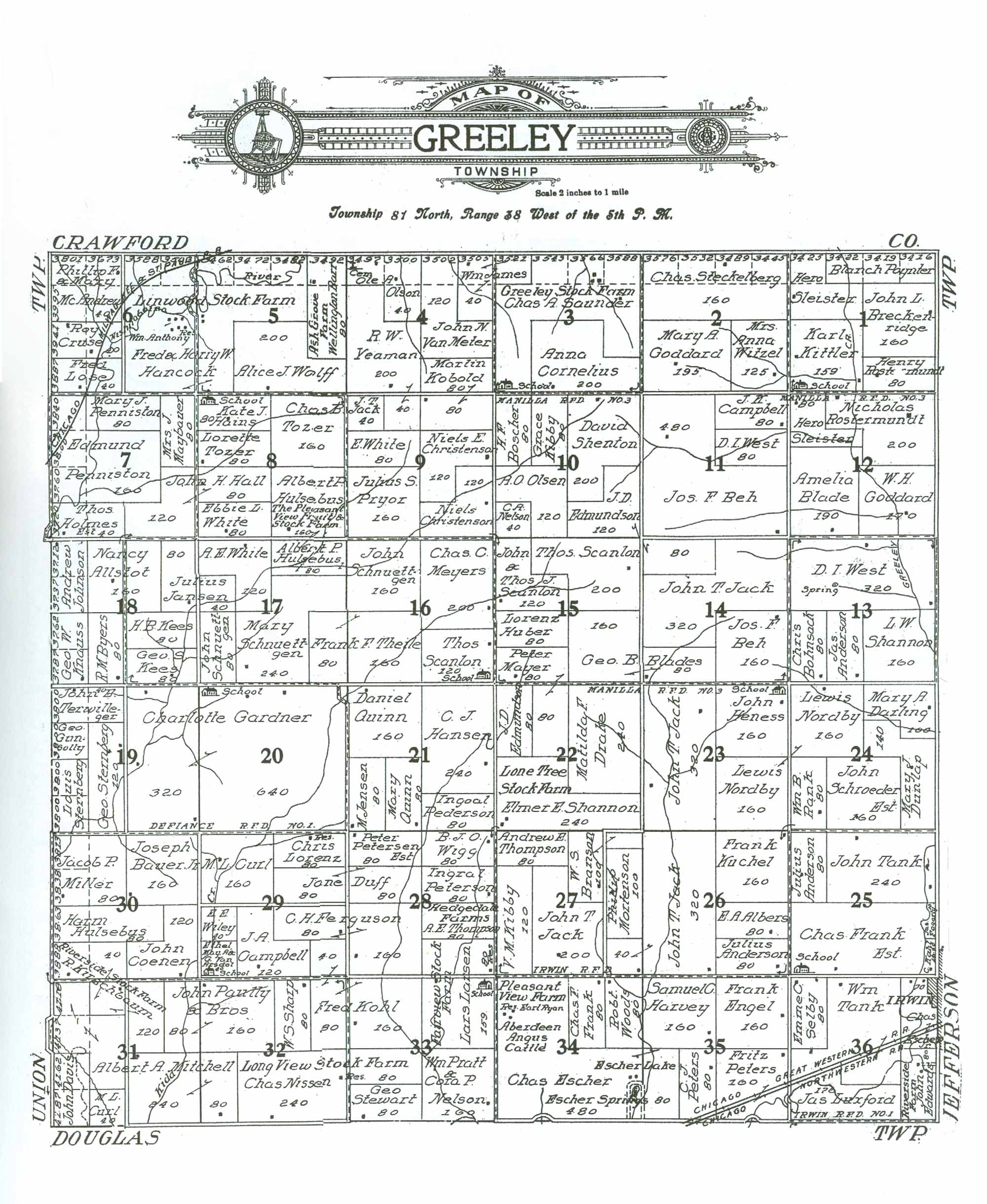 1911 GREELEY TOWNSHIP RESIDENTS
|
| LAST NAME | FIRST NAME | SECTION # | ACRES | COMMENTS |
|---|---|---|---|---|
| Albers | E. A. | 26 | 80 | |
| Allstot | Nancy | 18 | 160 | |
| Anderson | Jas. | 13 | 80 | |
| Anderson | Julius | 25 | 80 | |
| Anderson | Julius | 26 | 80 | |
| Barr | Wellington | 5 | 80/120 | "Ash Grove Farm" Map indicates 80 acres; appears to be more like 120 |
| Bauer Jr. | Joseph | 30 | 160 | |
| Beh | Jos. F. | 11 | 480 | |
| Beh | Jos. F. | 14 | 160 | |
| Blade | Amelia | 12 | 190 | |
| Blades | Geo. B. | 14 | 80 | Owns property in adjoining Section 15 |
| Blades | Geo. B. | 15 | 160 | Owns property in adjoining Section 14 |
| Bohnsack | Chris | 13 | 80 | |
| Boscher | H. F. | 10 | 80 | |
| Branson | W. S. | 27 | 100 | |
| Breckenridge | John L. | 1 | 160 | |
| Byers | R. M. | 18 | 80 | |
| Campbell | J. A. | 29 | 120 | |
| Campbell | J. K. | 11 | 80 | |
| Cemetery | 4 | 0 | Located in NW corner of property owned by Ole A. Olson | |
| Christenson | Niels | 9 | 120 | |
| Christenson | Niels E. | 9 | 120 | |
| Coenen | John | 30 | 120 | |
| Cornelius | Anna | 3 | 200 | |
| Cruse | Ray | 6 | 40/80 | Map indicates 40 acres; appears to be more like 80 |
| Curl | M. L. | 29 | 160 | |
| Curl | M. L. | 31 | 40 | |
| Darling | Mary A. | 24 | 120 | |
| Davis | John | 31 | 80 | |
| Drake | Matilda F. | 22 | 240 | |
| Duff | Jane | 28 | 80 | Owns property in adjoining Section 29 |
| Duff | Jane | 29 | 80 | Owns property in adjoining Section 28 |
| Dunlap | Mary J. | 24 | 140 | |
| Edmundson | J. D. | 10 | 120 | Owns property in adjacent Section 14 |
| Edmundson | J. D. | 14 | 80 | Owns property in adjacent Section 10 |
| Edmundson | J. D. | 22 | 80 | |
| Edwards | John | 36 | 80 | "Riverside Farm" |
| Engel | Frank | 35 | 160 | |
| Esher | Chas. | 34 | 480 | "Pleasant View Farm" "Aberdeen Angus Cattle" "Escher Springs" located in SE corner of prop. |
| Esher | Chas. | 35 | 80 | Owns property in adjoining Section 34 |
| Esher Jr. | Chas. | 36 | 70 | |
| Ferguson | C. H. | 28 | 160 | Owns property in adjoining Section 29 |
| Ferguson | C. H. | 29 | 80 | Owns property in adjoining Section 28 |
| Frank | Chas. F. | 34 | 80 | |
| Frank Est. | Chas. | 25 | 320 | "School" located in SW corner of property |
| Gardner | Charlotte | 19 | 320 | Owns property in adjoining Section 20 |
| Gardner | Charlotte | 20 | 640 | Owns property in adjoining Section 19 |
| Goddard | Mary A. | 2 | 195 | |
| Goddard | W. H. | 12 | 170 | |
| Gunsolly | Geo. | 19 | 40 | |
| Hains | Kate J. | 8 | 80 | "School" located on NW corner of property |
| Hall | John H. | 7 | 120 | Owns property in adjoining Section 8 |
| Hall | John H. | 8 | 80 | Owns property in adjoining Section 7 |
| Hancock | Fred & Harry W. | 5 | 320 | "Linwood Stock Farm" Own property in adjoining Section 6 |
| Hancock | Fred & Harry W. | 6 | 320 | "Linwood Stock Farm" Own property in adjoining Section 5 |
| Hansen | C. J. | 21 | 240 | |
| Harvey | Samuel C. | 35 | 160 | |
| Heness | John | 23 | 160 | "School" located in NE corner of property |
| Holmes Est. | Thos. | 7 | 40/80 | Map indicates 40 acres; appears to be more like 80. |
| Huber | Lorenz | 15 | 80 | |
| Hulsebus | Albert P. | 8 | 160 | "The Pleasant View Fruit & Stock Farm" |
| Hulsebus | Albert P. | 17 | 80 | Owns property in adjoining Section 8 |
| Hulsebus | Harm | 30 | 80/120 | Map indicates 80 acres, but appears to be more like 120 |
| Irwin (Municipality) | 36 | 10 | Acreage estimated; property in NE corner of Section | |
| Jack | J. T. | 9 | 40 | |
| Jack | John T. | 14 | 320 | |
| Jack | John T. | 23 | 320 | |
| Jack | John T. | 26 | 320 | Owns property in adjoining Section 27 |
| Jack | John T. | 27 | 40 | Owns property in adjoining Section 26 |
| Jack | John T. | 27 | 200 | |
| James | Wm. | 3 | 40 | Owns property in adjoining Section 4 |
| James | Wm. | 4 | 80 | Owns property in adjoining Section 3 |
| Jansen | Julius | 18 | 80 | Owns property in adjoining Section 17 |
| Jansen | Julius | 17 | 40 | Owns property in adjoining Section 18 |
| Jensen | M. | 21 | 80 | |
| Johnson | Andrew | 18 | 80 | |
| Kees | Geo. S. | 18 | 80 | |
| Kees | H. B. | 18 | 80 | |
| Kibby | Grace | 10 | 80 | |
| Kibby | V. M. | 27 | 120 | |
| Kirschbaum | R. | 30 | 40/80 | "Riverside Stock Farm." Map shows 40 acres, appears to be more like 80; owns property in adjoining Section 31 |
| Kirschbaum | R. | 31 | 120 | "Riverside Stock Farm." Owns property in adjoining Section 30 |
| Kittler | Karl | 1 | 159 | "School" located on SW corner of property; assuming 1 acre provided to it. |
| Knauss | Geo. W. | 18 | 80 | |
| Kobold | Marlin | 4 | 80 | |
| Kobold | Martin | 9 | 80 | Owns property in adjoining Section 4 |
| Kohl | Fred | 29 | 40 | Owns property in adjoining Section 33 |
| Kohl | Fred | 32 | 80 | Owns property in adjoining Sections 29 and 33 |
| Kohl | Fred | 33 | 160 | Owns property in adjoining Section 32 |
| Kuchel | Frank | 26 | 160 | |
| Larsen | Lars | 28 | 80 | "Fairview Stock Farm" |
| Larsen | Lars | 33 | 159 | "School" located in NE corner of property; assumed 1 acre provided to it. |
| Lorenz | Chris | 29 | 80 | |
| Lose | Fred | 6 | 40/80 | Map indicates 40 acres; appears to be more like 80 |
| Luxford | Jas. | 36 | 176 | |
| May/Van Arsdol | Ethel/A. & G. | 29 | 40 | "School" located in SW corner of parcel |
| Maybauer | Mrs. J. | 7 | 80 | |
| Mayer | Peter | 15 | 80 | Owns property in adjoining Section 22 |
| Mayer | Peter | 22 | 80 | Owns property in adjoining Section 15 |
| McAndrew | Phillip F. & Mary | 6 | 40/160 | Map indicates 40 acres; appears to be more like 160 |
| Meyers | Chas. C. | 16 | 200 | |
| Miller | Jacob P. | 30 | 80/160 | Map indicates 80 acres, but appears to be more like 160 |
| Mitchell | Albert A | 32 | 80 | Owns property in adjoining Section 31 |
| Mitchell | Albert A. | 31 | 320 | |
| Mortenson | Phillip | 27 | 100 | |
| Nelson | C. A. | 10 | 40 | |
| Nissen | Chas. | 33 | 80 | Owns property in adjoining Section 32 |
| Nissen | Chas. | 32 | 240 | Owns property in adjoining Section 33 |
| Nordby | Lewis | 23 | 160 | Owns property in adjacent Section 24 |
| Nordby | Lewis | 24 | 140 | Owns property in adjacent Section 23 |
| Olsen | A. O. | 10 | 120 | |
| Olson | Ole A. | 4 | 40/120 | Map indicates 40 acres; appears to be more like 120. "Cemetery" on NW corner of property |
| Paully & Bros. | John | 31 | 80 | Owns property in adjoining Section 32 |
| Paully & Bros. | John | 32 | 160 | Owns property in adjoining Section 31 |
| Pederson | Ingoal | 21 | 80 | |
| Penniston | Edmund | 7 | 160/280 | Map indicates 160 acres; appears to be more like 280 |
| Penniston | Mary J. | 7 | 80 | |
| Peters | C. J. | 35 | 80 | |
| Peters | Fritz | 35 | 160 | |
| Petersen Est. | Peter | 28 | 80 | |
| Peterson | Ingral | 28 | 80 | |
| Poynter | Blanch | 1 | 120 | |
| Pratt/Nelson | Wm./Cora P. | 33 | 160 | |
| Pryor | Julius S. | 9 | 160 | |
| Quinn | Daniel | 21 | 160 | |
| Quinn | Mary | 21 | 80 | |
| Rank | Wm. B. | 24 | 80 | |
| Rost??mundt | Henry | 1 | 80 | Unable to read complete last name |
| Rostermundt | Nicholas | 12 | 200 | |
| Saunder | Chas A. | 3 | 400 | "Greeley Stock Farm" "School" located on SW corner of property |
| Scanlon | John & Thos. J. | 15 | 120 | |
| Scanlon | Thos. | 15 | 200 | |
| Scanlon | Thos. | 16 | 120 | "School" located in SE corner of property |
| Schnuettgen | John | 16 | 160 | |
| Schnuettgen | John | 17 | 80 | |
| Schnuettgen | Mary | 17 | 240 | |
| School | 1 | 1 | Located in SW corner of property owned by Karl Kittler | |
| School | 3 | 0 | Located in SW corner of property owned by Chas. A. Saunder | |
| School | 8 | 0 | Located on NW corner of property owned by Kate J. Hains | |
| School | 16 | 0 | Located in SE corner of property owned by Thos. Scanlon | |
| School | 23 | 0 | Located in NE corner of property owned by John Heness | |
| School | 25 | 0 | Located in SW corner of property owned by Chas. Frank Est. | |
| School | 29 | 0 | Located in SW corner of property owned by Ethel May and A. & G. Van Arsdol | |
| School | 33 | 1 | Located in NE corner of Section property owned by Lars Larsen | |
| Schroeder Est. | John | 24 | 160 | |
| Selby | Emme C. | 36 | 80 | |
| Shannon | Elmer E. | 22 | 240 | "Lone Tree Stock Farm" |
| Shannon | L. W. | 13 | 160 | |
| Sharp | W. S. | 32 | 80 | |
| Shenton | David | 10 | 200 | |
| Sleister | Hero | 1 | 120 | |
| Sleister | Hero | 12 | 80 | |
| Steckelberg | Chas. | 2 | 160/320 | Map indicates 160 acres; appears to be more like 320 |
| Sternberg | Geo. | 19 | 120 | |
| Sternberg | Louis | 19 | 80 | |
| Stewart | Geo. | 33 | 80 | |
| Tank | John | 25 | 240 | |
| Tank | Wm. | 36 | 224 | |
| Terwilleger | John E. | 19 | 40/80 | Map indicates 40 acres; actual size more like 80 |
| Theile | Frank F. | 16 | 160 | Owns property in adjoining Section 17 |
| Theile | Frank F. | 17 | 80 | Owns property in adjoining Section 16 |
| Thompson | A. E. | 28 | 80 | "Hedgedale Farms" |
| Thompson | Andrew E. | 27 | 80 | |
| Tozer | Chas. B. | 8 | 160 | |
| Tozer | Lorette | 8 | 80 | |
| Van Meter | John N. | 4 | 120/160 | Map indicates 120 acres; appears to be more like 160 |
| West | D. I. | 11 | 80 | |
| West | D. I. | 13 | 320 | Spring located on property |
| White | A. E. | 17 | 120 | |
| White | E. | 9 | 80 | |
| White | Ellie L. | 8 | 80 | |
| Wigg | B. J. O. | 28 | 80 | |
| Wiley | E. E. | 29 | 40 | |
| Witzel | Mrs. Anna | 2 | 125 | |
| Wolff | Alice J. | 5 | 200 | |
| Woods | Robt. | 34 | 80 | |
| Yeaman | R. W. | 4 | 200 | |
| Yeaman | R. W. | 9 | 40 | Owns property in adjoining Section 4 |
Transcribed by Denise Wurner, December, 2012.
Please notify the Shelby Coordinator of any transcription errors.