|
|
Shelby County |

1911 CASS TOWNSHIP PLAT MAPClick on map to enlarge.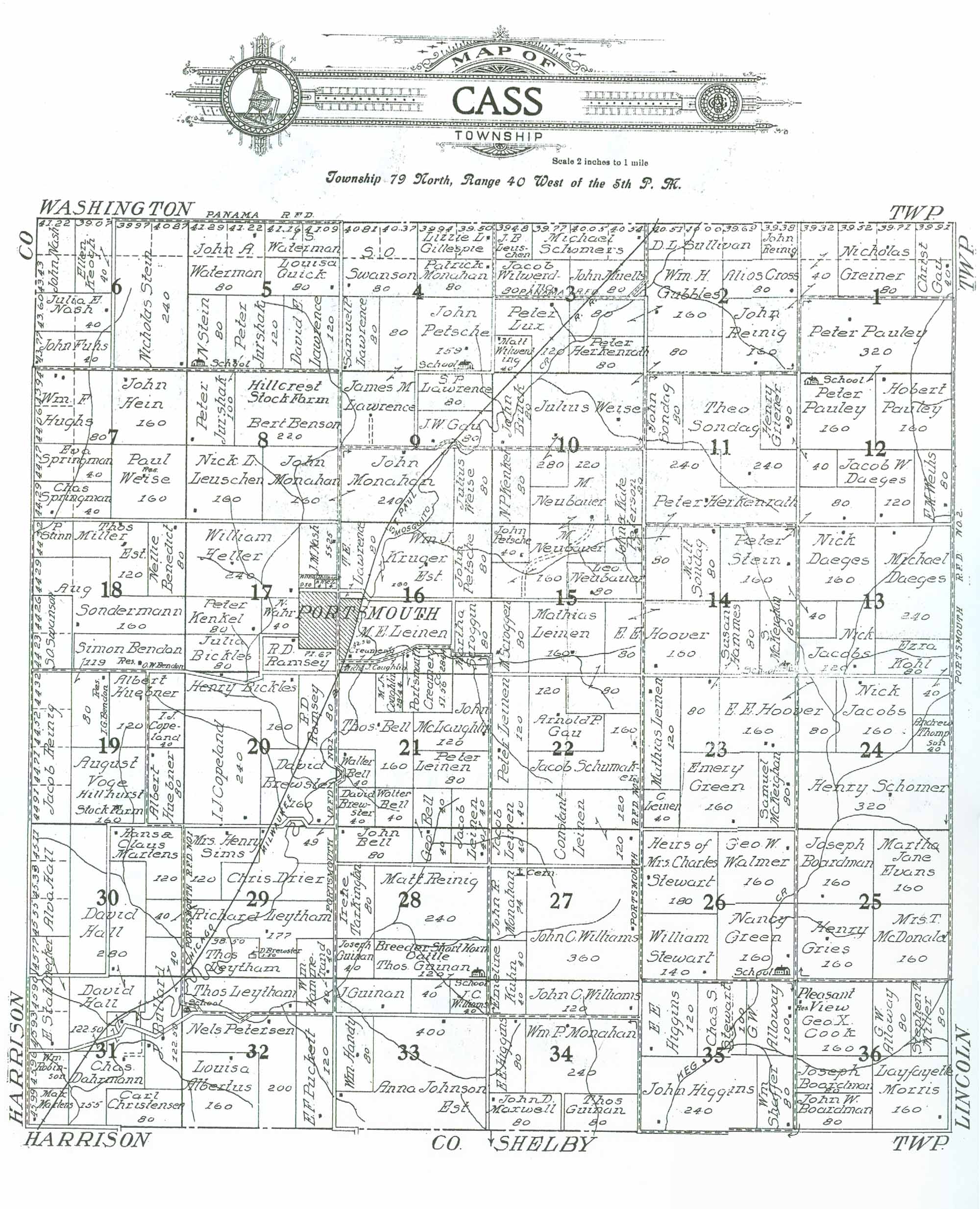 1911 CASS TOWNSHIP RESIDENTS
|
| LAST NAME | FIRST NAME | SECTION # | ACRES | COMMENTS |
|---|---|---|---|---|
| Albertus | Louisa | 32 | 160 | |
| Alloway | G. W. | 35 | 100 | |
| Alloway | G. W. | 36 | 80 | |
| Bell | George | 21 | 40 | Adjoins property in Section 28 owned by same person |
| Bell | George | 28 | 40 | Adjoins property in Section 21 owned by same person |
| Bell | John | 28 | 80 | |
| Bell | Thos. | 21 | 160 | |
| Bell | Walter | 21 | 40 | |
| Bell | Walter | 21 | 40 | |
| Bendon | O. W. | 18 | 1 | Assumed 1 acre for residence within property owned by Simon Bendon |
| Bendon | Simon | 18 | 119 | Adjoins property in Section 19 owned by same person |
| Bendon | Simon | 19 | 80 | Residence of I. G. Bendon indicated on property; no acreage allocated; Adjoins property in Section 18 owned by same party. |
| Benedict | Nellie | 18 | 80 | |
| Benson | Bert | 8 | 220 | "Hillcrest Stock Farm" |
| Bickles | Henry | 20 | 160 | |
| Bickles | Julia | 17 | 80 | |
| Boardman | John W. | 36 | 80 | |
| Boardman | Joseph | 25 | 160 | |
| Boardman | Joseph | 36 | 80 | |
| Brewster | D. | 29 | 1.5 | Property surrounded by that of Thos. Leytham |
| Brewster | David | 21 | 40 | |
| Brewster | David | 29 | 49 | Adjoins property in Section 20 owned by same person |
| Brewster | David | 20 | 160 | Adjoins property in Section 29 owned by same person |
| Bruck | John | 10 | 80 | |
| Bullard | J. | 30 | 40 | Adjoins property in Section 31 owned by same person |
| Bullard | J. | 31 | 122.5 | Adjoins property in Section 30 owned by same person |
| Cemetery | 27 | 6 | Acreage is assumed remaining portion of J. Monahan's property | |
| Christensen | Carl | 31 | 80 | |
| Cook | Geo. X. | 36 | 160 | "Pleasant View Residence" |
| Copeland | I. J. | 19 | 40 | |
| Copeland | I. J. | 20 | 240 | |
| Coughlin | M. J. | 21 | 28.44 | Adjoins property in Section 16 owned by same person |
| Coughlin | Michl. J. | 16 | 52.56 (?) | Acreage # illegible; Adjoins property in Section 21 owned by same person |
| Cross | Alios | 2 | 80 | |
| Daeges | Jacob W. | 12 | 120 | |
| Daeges | Michael | 13 | 240 | |
| Daeges | Nick | 13 | 160 | |
| Dahrmann | Chas. | 31 | 155 | |
| Drier | Chris | 29 | 0/154 | Acreage calculated from remainder in Section |
| Evans | Martha Jane | 25 | 160 | |
| Fuhs | John | 6 | 40/80 | Map indicates 40; appears to be approx. 80 |
| Gau | Arnold P. | 22 | 120 | |
| Gau | Christ. | 1 | 40/80 | Map indicates 40; appears to be approx. 80 |
| Gau | J. W. | 9 | 80 | |
| Gillespie | Lizzie L. | 4 | 0/80 | Acreage not indicated on map; estimated visually |
| Green | Emery | 23 | 160 | |
| Green | Nancy | 26 | 160 | School indicated on property |
| Greiner | Henry | 11 | 80 | Adjoins property in Section 12 owned by same person |
| Greiner | Henry | 12 | 40 | Adjoins property in Section 11 owned by same person |
| Greiner | Nicholas | 1 | 80/160 | Map indicates 80; appears to be approx. 160 |
| Gries | Henry | 25 | 160 | |
| Gubbles | Wm. H. | 2 | 160 | Adjoins property in Section 3 owned by same person |
| Gubbles | Wm. H. | 3 | 80 | Adjoins property in Section 2 owned by same person |
| Guinan | J. | 33 | 0/80 | |
| Guinan | Joseph | 28 | 40 | |
| Guinan | Thos. | 28 | 120 | "Breeder short horn cattle." "School" also noted on property |
| Guinan | Thos. | 33 | 40 | Adjoins property in Section 28 owned by same person |
| Guinan | Thos. | 34 | 80 | |
| H. | A. | 17 | 4 | Initials only indicated on map |
| Hall | Alva | 30 | 0/120 | |
| Hall | David | 30 | 280 | Adjoins property in Section 31 owned by same person |
| Hall | David | 31 | 122.5 | Adjoins property in Section 30 owned by same person |
| Hammerand | Wm. | 29 | 40 | Adjoins property in Section 32 owned by same person |
| Hammerand | Wm. | 32 | 40 | Adjoins property in Section 29 owned by same person |
| Hammes | Susan | 14 | 80 | Adjoins property in Section 23 owned by same person |
| Hammes | Susan | 23 | 80 | Adjoins property in Section 14 owned by same person |
| Handy | Wm. | 33 | 80 | |
| Hein | John | 7 | 160 | |
| Heller | William | 17 | 240 | |
| Herkenrath | Peter | 3 | 80 | |
| Herkenrath | Peter | 11 | 240 | Adjoins property in Section 14 owned by same person |
| Herkenrath | Peter | 14 | 80 | Adjoins property in Section 11 owned by same person |
| Higgins | E. E. | 34 | 80 | |
| Higgins | E. E. | 35 | 120 | |
| Higgins | John | 35 | 240 | |
| Hoover | E. E. | 14 | 160 | Adjoins property in Section 15 owned by same person |
| Hoover | E. E. | 15 | 80 | Adjoins property in Section 14 owned by same person |
| Hoover | E. E. | 23 | 160 | Adjoins property in Section 24 owned by same person |
| Hoover | E. E. | 24 | 80 | Adjoins property in Section 23 owned by same person |
| Huebner | Albert | 19 | 120 | |
| Huebner | Albert | 19 | 80 | |
| Hughs | Wm. F. | 7 | 80/160 | |
| Jacobs | Nick | 13 | 120 | |
| Jacobs | Nick | 24 | 160 | |
| Johnson Est. | Anna | 33 | 400 | |
| Jurshak | Peter | 5 | 120 | |
| Jurshak | Peter | 8 | 100 | |
| Kenkel | N. P. | 10 | 80 | |
| Kenkel | Peter | 17 | 80 | |
| Keogh | Ellen | 6 | 40/80 | Map indicates 40; appears to be approx. 80 |
| Kohl | Ezra | 13 | 80 | Adjoins property in Section 24 owned by same person |
| Kohl | Ezra | 24 | 40 | Adjoins property in Section 13 owned by same person |
| Kruger Est. | Wm. J. | 16 | 160 | |
| Kuhn | Emeline | 27 | 40 | Adjoins property in Section 34 owned by same person |
| Kuhn | Emeline | 34 | 40 | Adjoins property in Section 27 owned by same person |
| L. | C. | 17 | 4 | Initials only indicated on map |
| Lawrence | David E | 5 | 120 | |
| Lawrence | James | 4 | 80 | Adjoins property in Section 9 owned by same person |
| Lawrence | James M. | 9 | 0/160 | Adjoins property in Section 4 owned by same person |
| Lawrence | S. P. | 9 | 80 | |
| Lawrence | Samuel P. | 4 | 80 | |
| Lawrence | T. E. | 16 | 80 | |
| Leinen | Constant. | 22 | 120 | Adjoins property in Section 27 owned by same person |
| Leinen | Constant. | 27 | 120 | Adjoins property in Section 22 owned by same person |
| Leinen | G. | 23 | 40 | |
| Leinen | Jacob | 21 | 40 | Adjoins property in Section 28 owned by same person |
| Leinen | Jacob | 22 | 40 | Adjoins property in Section 27 owned by same person |
| Leinen | Jacob | 27 | 40 | Adjoins property in Section 22 owned by same person |
| Leinen | Jacob | 28 | 40 | Adjoins property in Section 21 owned by same person |
| Leinen | M. E. | 16 | (?) | No acreage amount given; Township of Portsmouth partially within Section |
| Leinen | Mathias | 15 | 160 | Adjoins property in Section 22 owned by same person |
| Leinen | Mathias | 22 | 80 | Adjoins property in Section 15 owned by same person |
| Leinen | Mathias | 23 | 120 | |
| Leinen | Peter | 21 | 80 | |
| Leinen | Peter | 22 | 120 | |
| Leuschen | J. B. | 3 | 0/40 | |
| Leuschen | Nick L. | 8 | 160 | |
| Leytham | Richard | 29 | 177 | Adjoins property in Section 30 owned by same person |
| Leytham | Richard | 30 | 40 | Adjoins property in Section 29 owned by same person |
| Leytham | Thos. | 29 | 98.5 | |
| Leytham | Thos. | 32 | 0/120 | "School" on property |
| Lux | Peter | 3 | 120 | |
| Martens | Hans & Claus | 30 | 120 | |
| Martens | Max | 31 | 0/40 | |
| Maxwell | John D. | 34 | 80 | |
| McDonald | Mrs. T. | 25 | 160 | |
| McKeighan | S. | 14 | 80 | |
| McKeighan | Samuel | 23 | 80 | |
| McLaughlin | John | 21 | 120 | |
| Miller Est. | Stephen T. | 36 | 80 | |
| Miller Est. | Thos. | 18 | 120 | |
| Monahan | John | 8 | 160 | Adjoins property in Section 9 owned by same person |
| Monahan | John | 9 | 240 | Adjoins property in Section 8 owned by same person |
| Monahan | John R. | 27 | 74 | Remaining 6 acres assumed to be cemetery property |
| Monahan | Patrick | 4 | 80 | |
| Monahan | Wm. P. | 34 | 240 | |
| Morris | Layfayette | 36 | 160 | |
| Muells | John | 3 | 80 | |
| Nash | J. M. | 17 | 55.25 | |
| Nash | John | 6 | 0/80 | Acreage not indicated on map; estimated visually |
| Nash | Julia E. | 6 | 40/80 | Map indicates 40; appears to be approx. 80 |
| Neubauer | Leo | 15 | 80 | |
| Neubauer | M. | 10 | 120 | Adjoins property in Section 15 owned by same person |
| Neubauer | M. | 15 | 160 | Adjoins property in Section 10 owned by same person |
| Ohlinger | Anna | 17 | (?) | Acreage # illegible; Township of Portsmouth partially within Section |
| Pauley | Hobert | 12 | 160 | |
| Pauley | Peter | 1 | 320 | Adjoins property in Section 12 owned by same party |
| Pauley | Peter | 12 | 160 | School on property; Adjoins property in Section 1 owned by same party |
| Petersen | Nels | 32 | 200 | |
| Peterson | John & Kate | 10 | 80 | Adjoins property in Section 15 owned by same person |
| Peterson | John & Kate | 15 | 40 | Adjoins property in Section 10 owned by same person |
| Petsche | John | 4 | 159/160 | School noted on section quarter; provided remaining 1 acre? |
| Petsche | John | 15 | 40 | |
| Petsche | John | 16 | 80 | |
| Portsmouth (Municipality) | 16 | ?? | Town of Portsmouth | |
| Portsmouth (Municipality) | 17 | ?? | Town of Portsmouth | |
| Portsmouth Creamery | 16 | 28.44 | ||
| Portsmouth Creamery | 21 | 51.56 | Adjoins property in Section 16 owned by same person | |
| Puckett | E. F. | 32 | 120 | |
| Quick | Louisa | 5 | 80 | |
| Ramsey | B. D. | 20 | 80 | |
| Ramsey | R. D. | 17 | 71.67 | |
| Reinig | Jacob | 19 | 0/160 | |
| Reinig | John | 1 | 40/80 | Map indicates 40; appears to be approx. 80 |
| Reinig | John | 2 | 0/40 | Acreage not indicated on map; estimated visually |
| Reinig | John | 2 | 160 | Adjoins property in Section 1 owned by same person |
| Reinig | Matt | 28 | 240 | |
| Robinson | Wm. | 31 | 0/40 | |
| Schomer | Henry | 24 | 320 | |
| Schomers | Michael | 3 | 0/120 | |
| Schumaker | Jacob | 22 | 160 | |
| Scroggen | M. | 15 | 80 | |
| Scroggin | Martha | 16 | 80 | |
| Shaffer | Wm. | 35 | 80 | |
| Sims | Mrs. Henry | 29 | 120 | |
| Sondag | John | 11 | 80 | |
| Sondag | Matt | 14 | 80 | |
| Sondag | Theo | 11 | 240 | |
| Sondermann | Aug. | 18 | 160/200 | |
| Springman | Chas. | 7 | 40/80 | |
| Springman | Eva | 7 | 40/80 | |
| Stahlnecker | E. | 31 | 0/80 | Adjoins property in Section 30 owned by same person |
| Stahlnecker | E. | 30 | 0/40 | Adjoins property in Section 31 owned by same person |
| Stein | N. | 5 | 80 | |
| Stein | Nicholas | 6 | 240/320 | Map indicates 240; appears to be approx. 3200 |
| Stein | Peter | 12 | 80 | Adjoins property in Section 14 owned by same person |
| Stein | Peter | 13 | 40 | Adjoins property in Section 14 owned by same person |
| Stein | Peter | 14 | 160 | Adjoins property in Section 12 owned by same person |
| Stewart | Chas. S. | 35 | 100 | |
| Stewart | Heirs of Mrs. Charles | 26 | 180 | |
| Stewart | William | 26 | 140 | |
| Stinn | P. | 18 | 0/40 | |
| Sullivan | D. L. | 2 | 0/120 | Acreage not indicated on map; estimated visually |
| Swanson | S. O. | 4 | 80/160 | Map indicates 80; appears to be approx. 160 |
| Swanson | S. O. | 18 | 0/80 | |
| Tarkington | Irene | 28 | 80 | |
| Thompson | Andrew | 24 | 40 | |
| Voge | August | 19 | 160 | "Hillhurst Stock Farm" |
| Wahr | N. | 17 | 40 | |
| Walmer | Geo. W. | 26 | 160 | |
| Waterman | I. S. | 5 | 0/80 | Acreage not indicated on map; estimated visually |
| Waterman | John A. | 5 | 80/160 | Map indicates 80; appears to be approx. 160 |
| Weihs | F. M. | 12 | 80 | |
| Weise | Julius | 2 | 80 | Adjoins property in Section 10 owned by same person |
| Weise | Julius | 9 | 80 | |
| Weise | Julius | 10 | 280 | |
| Weise | Paul | 7 | 160 | |
| Williams | J. C. | 33 | 40 | |
| Williams | John C. | 27 | 360 | |
| Williams | John C. | 34 | 120 | |
| Wilwerding | Jacob | 3 | 80 | |
| Wilwerding | Matt | 3 | 40 |
Transcribed by Denise Wurner, November, 2012.
Please notify the Shelby Coordinator of any transcription errors.