|
Communities of Poweshiek County
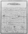
The 1896 map below shows the 16 townships
in
Poweshiek County.

Click the map to open in a full size
view.
~source: Atlas of Poweshiek County, Iowa, published by Geo.
A. Ogle & Co., 1896. Reproduced by the kind permission of the
University of Iowa Libraries Map Collection. The Atlas viewer has
several zoom levels, instead of the two we show here. The Atlas has
full-page maps of each township, street maps of the cities and towns,
portraits of leading citizens of Poweshiek County, and other
information.
(1896)
Atlas of Poweshiek County, Iowa has township and city maps,
portraits of leading citizens, a business directory, and general info.
(1914)
Atlas and Plat Book of Poweshiek County, Iowa has township maps,
farmers directory, and national info.
(1921)
Atlas of Poweshiek County, Iowa has township maps and many pages of
ads.
(1928) Farm Atlas of Poweshiek County, Iowa has township
maps and many pages of ads.
For genealogical purposes, the best city
maps
are probably the ones in the 1896 Atlas, above. For modern maps
of
Grinnell.
The state atlases also have maps of each
county, and lots of other information.
(1875)
Illustrated Historical Atlas of the State of Iowa has detailed
county maps, showing locations of individual farmhouses, roads, wooded
areas and creeks.
(1904)
Atlas of the State of Iowa has "topographical" county maps, showing
detail of roads, creeks and wooded areas, churches and schools, and a
large photo gallery of people and places.
Be sure to check out the
United States Digital Map Library
offered by USGenWeb Archives Project
Collection includes maps for :
- Indian Land Sessions
- States and Counties
- United States
|
The City-Data "Notable Locations" map is very useful.
(Scroll down or search the page.) It allows you to turn on or off the
notable locations, churches, cemeteries, lakes and reservoirs, creeks,
and parks.
If you can take the time to figure out
how to
use it to best advantage, the Poweshiek County Geographic Information System is
capable of significantly better aerial-photograph detail than Google
Maps. It also identifies current land-ownership, and provides
other information.
Note: "Grinnell" Township was renamed
"Grant"
Township in 1920.
|


