IOWA STORIES
Volume 2

By
CLARENCE RAY AURNER

Printed by the Clio Press Iowa City, Iowa 1918
Copyright 1918 by Clarence Ray Aurner

Transcribed by Sharon Elijah, June 21, 2013

II.
MANY COUNTIES IN PLACE OF TWO
pgs 19-29

Neither of the two large counties—Dubuque and Demoine—which had been formed west of the Mississippi by the law of Michigan in 1834, was changed in any way until late in 1836. By that time, as already mentioned in the first chapter, they had come under the control of the Territory of Wisconsin. But during the two years which had passed the settlers had begun to fill the eastern part of the present State of Iowa, and smaller divisions could be made as they probably wished. It was not possible when counties were so large to manage all the business connected with the laying out of roads, the collecting of taxes, and a great many other things. By a law of Wisconsin, therefore, Demoine County was made into seven divisions and each one, of course, was given a name; and the next year Dubuque County was divided into fourteen new counties. In each instance the old names of Demoine and Dubuque were kept; the first came to be spelled Des Moines. At the same time the county seat towns of those counties were not changed. Thus we have today the very counties and towns and even townships which the Michigan law named in 1834.

Very few persons, probably, have any acquaintance with the arrangement of the new counties as they were formed. As they were set apart, they sometimes had too few settlers to be organized (that is to have officers) at once so that they were joined to other counties; just as the territories of Wisconsin and Iowa had been attached to Michigan. For example, the county of Clayton was laid out north of Dubuque County and its county seat town had the pretty name of Prairie La Porte. But that town is no longer on the map, since Guttenberg has taken its place. It is not strange that many of the early names are French because at an early day, before the United States owned this land called Iowa, there were many French in that part of the Louisiana Purchase. When Clayton County was formed, Fayette County was north and west of it and Fayette boundaries extended to the limits of the Indian land. Delaware and Buchanan Counties were joined to Dubuque for the purpose of government and so they had no county seat towns. In Jackson County Bellevue was the seat of government, and to that county Jones, and Linn, and Benton counties were attached. It will be seen that the officers in Jackson County had to attend to the duties belonging to the four counties.

Clinton County was to be joined to Scott County; and the county seat town was to be either Davenport or Rockingham, as the voters might decide. Rockingham was some distance south of Davenport and for some time it was a rival of that city. Before the contest was finally decided, it became very exciting and more than one election was held to settle the question. At the first election held in 1838 the voters were to come to the hotel of Mr. H. W. Higgins at the town of Rockingham, at the hotel of Mr. John H. McGregor at Davenport, and at two private houses in the county. At these four places all the voters of the present county of Scott were to assemble on a certain day. It has been said that many who had no right to vote at all were brought in so that the election was not considered lawful. In fact, there were lawless men who did not care which place was selected, if they were paid for the voting. Such things have happened very often since then, although it has been made much harder for any one to vote unlawfully. The decision in Scott county was finally made in favor of Davenport.

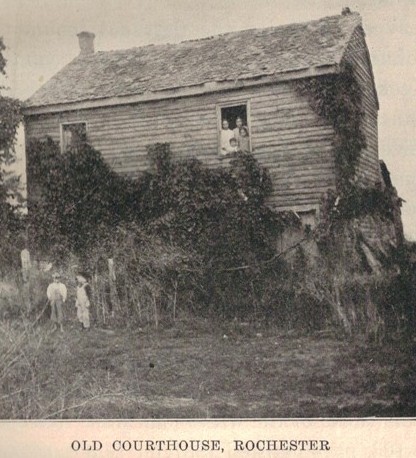
That was only one of the very many battles with votes over the location of the county seat town in the new counties. For example, when Clinton County was separated from Scott County, the voters again were to decide between Lyons and Camanche; and in Cedar County between the old town of Rochester, and Tipton, a new place staked out on the prairie and having no houses at all. Sometime before the big county of Dubuque had been divided, the town of Rochester had sprung up on the Cedar River. It was settled in 1836 and the people were certain that it would become a great city like the one in the state of New York for which it had been named. Of course, it expected to become the county seat; and yet the voters decided on the new town far away from the Cedar River. Even today there is an old building at Rochester which people who know call the court house. In fact, all the houses there are so old-fashioned that the place is very interesting.


pg 23

West of Cedar the first new county was Johnson, and beyond it was the county of Keokuk. Both of these were attached, or joined, to Cedar County in order to have officers who would attend to any business there until these counties had elections of their own. At the present time it is not quite clear how any county could have been laid out west of Johnson, since all west of that was yet (in 1837) Indian land. Indeed, the land there was not given up until 1842. Perhaps the men who made the law did not know just where the line dividing the Indian lands from those of the white man was. (See map, p. 163, part marked 1837).

In January, 1838, the old county of Demoine, which had been divided into seven others in 1836, was rearranged and a county which had been name Cook was left out. At the same time Fort Madison became the county seat of Lee county; while in Van Buren County the voters were to decide the whole question. Henry County had its capital at Mount Pleasant, and all the country lying west of that county, even to the Indian lands, was to be under its care. Lower Wapello was named in the territorial law as the seat of government of Louisa County, and the Bloomington (the old name of Muscatine until 1849) of “Musquitine”, or Muscatine County. The last of the seven counties made from the one large one of Demoine was called Slaughter, and its county seat town was Astoria. But it was not long until this was changed to Washington County with a town Washington as the county town. Now one cannot find the old name of Astoria upon the map of Iowa. Like a great many towns of the kind, it was, as they say, only on paper; and that means it was just laid out and never built. One might mention hundreds of such places in a new state. The county of Washington had to look after all the land lying west of it just as did Henry County. To be sure, as soon there were settlers enough there would be other new counties in this part of the Territory of Iowa.

When the two large counties (Dubuque and Demoine) were divided into the smaller ones, it was expected that each of the new divisions would pay its part of the debt that the old county owed; just as groups of men, for example, would agree to share in the cost of some service for all of them taken together. But counties do not feel as men do, and not all of them responded to the call of the officers of the old counties when they were asked to pay up. One might go to the court house in Dubuque and find at the office of the county auditor the exact amount which each of the fourteen counties owed as its share of the old debt. Again, in Cedar County there is another record to show that a man had been sent from Dubuque to collect the money. But Cedar County refused to pay its share; perhaps it had no money. Later the county of Cedar had trouble of its own in getting the county of Johnson which had been attached to it, as already pointed out, to pay its share of the taxes to carry on the county business; and yet the amount was so little it was hardly worth collecting. At that time taxes were very small, for very few men had much property; but it was probably as difficult to pay a few cents then as it is now to pay as many dollars.


pg 27

In 1840 Benton County, which had been joined to Jackson since 1837, was put under the care of the recently organized county of Linn. In 1844 the counties of Keokuk and Mahaska were given offices of their own, and the land west of Mahaska as far as the Indian country—a long distance at that time—was attached to it. It will be remembered that in Iowa Stories, Book One (p. 40), it was said that a ferry which was across the Des Moines River near where the city of Des Moines is now had been licensed, that is allowed to be run, by the owner, Mr. Scott, by the officers of Mahaska County. All will understand now how that happened; for anything which had to be governed by a county officer would need to be written down at the county seat town of the county to which the outside land was joined for the purposes of government.

In 1844, also, the county of Wapello was allowed to have its own government and to elect its officers. At the same time three men called commissioners were named to fix upon a place for the county seat. It was quite customary in such cases to find three men, none of whom lived in the county in which the selection was to be made; they met at the house of some settler and, after looking about, they were supposed to decide upon the most suitable place. Those who had to perform this duty in Wapello County met at the house of a Mr. Wilson, who lived near the old Indian agency. Again, in 1846, Benton County, which had been mentioned as joined first to Jackson and then to Linn county, was finally given its own officers. It had to take care of Tama and other counties to the west of it and of Black Hawk on the north. During the same year (in 1846) twelve counties in the central part of the State, as far as Boone County and along a north and south line marked by Dallas, Madison, and Clarke counties, were separately named in one law of the legislature (See a map of Iowa).


Return to Iowa Stories Volume 2 Contents

Return to Index of History Books

Back to Muscatine Co. IAGenWeb, Index Page

Page created June 29, 2013 by Lynn McCleary