

| MUSCATINE COUNTY, IOWA | |
Page 93
The county of Muscatine, was organized by an act of the Territorial Legislature that met at Belmont, in October, 1836, although no county records shows when the organization was perfected. The earliest preserved record was that of a marriage license issue to Andrew J. Starkes and Marilla Lathrop, granted by Robert McClaren, clerk of the Commissioner’s Court, dated February 13, 1837.
The Act also says that the District Court shall be held in Bloomington, in the County of Muscatine, on the fourth Monday of April and September of each year, this is all of the location of the county Seat I can find prior to the old marriage record.
Bloomington, now Muscatine, is situated at the apex of the great bend of the Mississippi river, in Latitude 71 degrees 25 minutes North, Longitude 91 degrees, 8 minutes, 20 seconds West.
It was originally known by the early explorers as the Sand Stone Bluff. It seems to have been a point of considerable interest to the Indians here. Government issued corn to the red men in compliance with a former treaty there. Col. George Davenport built the first house, a trading house, within the county, in the year 1833, and located a man by the name of Farnum to trade with the Indians. It was located on Front street, near the east side of Iowa avenue. This trading house and claim was purchased by John Vannotta and Benjamin Clark, Feb. 20, 1836, who after taking possession, proceeded in the spring of 1836, to lay out the town of Bloomington. John Vannatta gave it the name of Bloomington, after a place of that name he had formerly lived at in Illinois.
He had the town laid out a half mile square, using the west side of the house as a starting point for the center line, within two years he sold most of his interest to different parties and retired to his farm some three miles west of the city. He still retained an interest in the name of Bloomington, and defeated several efforts made in the Legislature to change the name. It was finally changed to Muscatine by the courts.
At the time of the treaty of 1832, there were two Indian villages within the county. Keokuk, the leading chief’s village, was located near the head of Keokuk Lake, some six miles west of the city. Poweshiek’s village, another one of the principal chiefs, was located on the west side of Cedar River, near the Saulsburg bridge, some 12 miles north-west from Muscatine, these villages were abandoned in 1836, although the Indians reserved the right to hunt in the county for two years later. They were occasional visitors for several years.
The principal road used for the first two years after the imigrants were allowed to enter the Territory was the Indian trail, one of them is yet visible in the West Park. The first territorial road was laid off in 1836, and a mail route established in 1837. The first Post Office was at the mouth of Pine Creek. Letters directed to it read: Iowa Post Office, Mouth of Pine River, Black Hawk Purchase, Wisconsin Territory. If the letter traveled over five hundred miles it had 25 cents postage attached.
Salem, now Fairport, Geneva and Bloomington soon got Post Offices. For two years previous to 1840, there were four mails a week, two north and two south. The route was from Burlington to Dubuque, carried in stage coaches or covered wagons.
The first actual settlers in the county, if we do not consider Davenport’s Indian trader, Farnam, a settler, was Benjamin Nye, who settled near the mouth of Pine Creek in 1834. Mrs. Laura Nye Patterson, who came here with her father, is now lining in our city. Err and Lot Thornton settled soon after in the southern part of the county.
A large portion of the first settlers came by steamboats up the river, and brought their supplies with them. If the river was low, or the winter long, supplies had to be hauled from St. Louis with teams, it made them quite dear, for instance, during the winter of 1838-39, common salt sold for six dollars a hundred, and other merchandise in proportion.
The Episcopal Society was the first religious organization within the county. They built the first church building in connection with the masons who occupied the upper story, it was finished in the year 1841.
This church was used by the Presbyterians for several years in connection with the Episcopal Society. The Catholics built the second church in 1842. The third was built by the Baptists. The fourth by the Congregational Society under Rev. A. B. Robbins. The Methodist acquired an old school building and used that for church purposes. During the early days the Court House was used for holding religious meetings.
The Court House was erected in 1840-41, at a cost of some $15,000, secured from the sale of town lots on land entered by the county. It was burned out in 1864. The walls were not damaged and the building was restored substantially as it was before the fire. The transcept across the rear was then added. The present city Hall was the first Methodist church, it was dedicated in 1854. The Presbyterians erected their first church on Mulberry street, east of the Court House.
The lot for the First African M. E. Church was purchased in 1848, the church organized October 10, 1849, and a church was built soon after.
Benjamin Nye built the first grist mill in the county on Pine Creek, it is still in use.
There were several other mills built at an early date, a sawmill on Sweetland Creek, two grist mills on the Litringer Creek, one on the Wapsenock, one on Mad Creek near 9th street; they have all disappeared.
The first steam saw-mill was erected at Geneva, owned by Dr. Ely Reynolds and john Lawson, it was erected in 1837, in 1842 it was moved to Bloomington, and located on Mad Creek, near the Gass House, and run by Vannotter and Deshler, and later by Robert and Samuel Kinney.
We had a woolen factory erected in the early forties, that was propelled by water from the Kencaid Run and the Millers’ Spring, it did considerable wool carding, but eventually dropped into oblivion.
The first school house built in the city was erected by a Paint Stock Company, it stood on the west side of Iowa Avenue, between 2nd and 3rd streets. The Methodists got control of it and converted it into a meeting house.
The first hotel was built by Robert Kinney in 1846, it stood on the west corner of Front and Chestnut streets.
There are other important points within the county.
WEST LIBERTY was originally located about one and a half miles to the northwest of the present location. It was laid out by Simon A. Bagley in 1838. A Post Office was established there, with Mr. Bagley as Post Master, the same year the first store was opened by Peter Heath, later it was the dinner station for the stages between Bloomington and Iowa City. Freeman Alger kept the hotel and Post Office. It had a Masonic Hall, a respectable two story building that was moved to the new town. The present or new town was laid out in 1856, by John M. Spencer, T. J. Robinson, and J. W. Clark, W. C. Evans was the local agent and attended to selling the lots. The town was incorporated in 1868. There has been several additions made to the town by different parties.
It was but a very ordinary way station until the construction of the Burlington, Cedar Rapids & Northern R. R., and its connections with the rock Island & Pacific R. R. The two roads make it one of the liveliest railroad points in the state.
It is claimed that the first school in this county west of Cedar River was taught by Valentine Borarth, was in or near this town, and that the first regular school house was built in 1843, near the old town, on the land of Asa Gregg, who was for many years the county School Fund Commissioner.
In 1864 the present school district was organized, and a school house was built in 1867.
WILTON, like many other western cities, was a town of railroad origin in 1853, after the M. &R. R., now the C. R. I. & P. R. R. had been located. Mr. F. Butterfield purchased of Mr. Kauffman 205 1/2 acres of land for $2.00 per acre.
In 1854, Messrs. Green & Stone, of Muscatine, bought one-fifth interest, at $10.00 acre, they also bought 40 acres of Mr. Marolf at the same price. In September, 1854, Butterfield and Greene & Stone laid out the original town and recorded it on October 22, 1855. Like most other thrifty towns, several additions have been added. In 1854 the first lot was sold to Mr. Henry S. Giesler, for $40.00, who built the first house in 1855. On October 1, 1855, the construction train reached Wilton, on December 1st, the road was opened for passengers.
During the winter of 1855-56, a large number of lots were sold, and during the season of 1856 Wilton became a noted point, with many buildings and much business.
NICHOLS, another railroad town, was platted by George Baumgardner, and filed for recording June 22, 1871, by Benjamin Nichols, the owner of the town site. When the Muscatine Western reached the town in 1873, an addition was laid out. The second addition was laid out by S. Nichols in 1875.
MOSCOW is one of the old towns. It was laid out in the fall of 1836, by a Mr. Webster and Dr. Charles Drury, later Mr. Biglow laid out an addition.. In 1866, a dam was built across the Cedar River, and a mill built in 1867, which, like many other schemes of early days, proved an unfortunate investment.
CONESVILLE was laid out in 1870, and was named after its founder, Beebe S. Cone.
ATALISSA was platted and filed for record by John P. Cook and William Lundy, January 31, 1856. Mr. Lundy being the former owner of the land.
PORT ALLEN was founded and the town platt recorded by Cyril Carpenter, Nov. 18, 1871. The depot was built by Carpenter and rented to the railroad company.
ADAMS was founded, platted and recorded by Elias Adams in July, 1873. Adams was R. R. Agent and Postmaster.
STOCKTON, generally known as Fulton, is situated near the northeast corner of the county on the C. R. I. & P. R. R. It was platted and recorded in September, 1855. The Post Office was named Prairie Mills.
FAIRPORT, originally called Salem, is one of the old towns. It …
Page 94
… was platted and filed for record by William Chambers, April 20, 1839, having been a point of some mention for two or more years previous. The development of its Potters' clay, fortunately gave it the nickname of Jugtown, although Fairport is the correct name.
FRUITLAND is about the latest of our county towns, it is located on the Muscatine Island, in the midst of the melon and sweet potato lands, the shipping of which is its principal business, and several hundred carloads are shipped annually. The first name selected for the town was “Melon,” a very appropriate name, but, not suiting the R. R. Company, it was rejected and Fruitland substituted without consulting the citizens.
MONTPELIER was probably the first town within the county limits, it was laid out by Benjamin Ney, probably in 1835 or 36. Here Nye opened a store, the Iowa Post Office was located here. Nye was in some way interested with a man known as Major Gordan, they fell out, Nye stabbed Gordan with a pocket knife. While Gordan was laid up with his wounds the clerk sold out the stock of goods and left. The town sloped, but the Township held the name ever afterwards. Since the C. R. I. & P. R. R. was opened along the river, quite a village has sprung up some two miles east of the first town, also by the name of Montpelier.
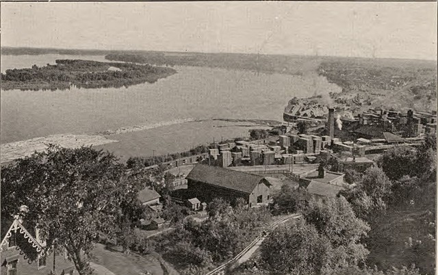
VIEW OF THE MISSISSIPPI AND SOUTH MUSCATINE, TAKEN FROM MUSCATINE HEIGHTS.
MUSCATINE, a city of 16,000 inhabitants, picturesquely situated on a bend on the west bank of the Mississippi river in longitude 91.05° w, latitude 41.26° n, 30 miles southwest from Davenport, 212 miles west of Chicago and 317 miles north of St. Louis. It is the junction point of the Kansas City branch and the Wilton branch of the C., R. I. & P. R. R. by which latter it connects at Wilton, 12 miles north, with the main line of the C., R. I. & P. R. R. The Muscatine Western, a branch of the B., C. R. & N. R. R., extending westward to Montezuma, has its terminal at Muscatine, as also the Muscatine North & South railroad extending from Muscatine to Elrich, where it connects with the Iowa Central system. It is hoped and expected that before a great while this latter road will form part of an extended system either now proposed or building.
A road has been surveyed from Davenport to a point beyond Muscatine and it is supposed that the C., M. & St. P. R. R. Company are backing this venture, but at this writing it would be rather risky to assert this as a fact. No doubt other roads are heading this way, and certainly will try and secure their portion of the trade of Muscatine. The city is beautifully located on a bend in the Mississippi river. From several points of its imposing bluffs extensive views of the river and the surrounding country can be obtained.
From one point of the bluff where the Catholic Church is located, Burlington, 60 miles away, can be seen on a clear day. From this same point as well as from numerous others west, a full view of the celebrated Muscatine Island can be had, which, with its sweet potato and melon patches, looks like a huge checker board in green and yellow colors.
The city is rather irregularly laid out. The original town platted parallel with the river angles 45° from a due north and south line and most other additions and sub-divisions of the city were laid out without any regard, whatever to continuous streets, but only to suit the lay of the land, which is very rolling. As a consequence the working of streets has been very expensive and to make connections with portions of the city as it was built, more streets were necessary than is usual in cities of the size of Muscatine. The city has over 200 streets, some very short it is true. The drainage of the city also was very difficult work as nearly all the rainfall ad to be carried by two creeks, one of them running through the heart of the city and the other east of it. Over eight blocks of the former creek are now arched over and that which was formerly an eyesore is now being used as a street, and most sewers drain into it.
The finished portion of the city presents a very fine appearance, the grades being easy and drainage perfect. Over nine miles of streets are brick paved and quite a number of others graded and macadamized. The work would have been extended farther, but for a decision of the supreme court of Iowa which prevents the levying of taxes for improvement purposes.
The management of city affairs is excellent as is shown by the fact that it was possible to refund the bonded debt amounting to $292,500 at the rate of 4 ½ per cent, which is considered very low. According to the report of City Clerk Benham dated March 18th, 1899, the total income of the city for the year ending March 1st, 1899, was, in round numbers $180,000, and out of this amount the city pays salaries to all its officers, water rent, maintains a very efficient volunteer fire department and police force, and for lighting the city by both electricity and gas. The assessment roll for this, when corrected by the council, will show a valuation of $2,500,000 upon which the probable tax levy will be 32 ½ mills.
The chief industries of the city in value of products, are its saw mills and wood working establishments, several of which ship their products to all parts of the United States and also to foreign countries. The saw mills of the city have an average annual output of over seventy-five million feet. Of this amount a very large proportion is consumed in the city by the sash, door and blind factories and the manufacturers of box shooks, one of the latter requiring over fifty million feet of lumber annually. The above mentioned factories use besides the lumber they secure here, large quantities shipped to them from other points.
The manufacture of Oat Meal is also an important industry, giving employment to a large number of persons and furnishing a ready market for all good oats that are offered.
* ~ * ~ * ~ * ~ * ~ * ~ * ~ * ~ * Return to 1899 Atlas Table of Contents
Back to City & County Directory Index
Return to Muscatine Co. IAGenWeb, Index Page
Page created February 6, 2021 by Lynn McCleary