Mills County, Iowa

General History Of Mills County
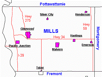
"Mills County, in the southwest corner of the state with an area of 441 square miles, is one of 99 counties in the "Hawkeye State."
Mills County Map
Topography
The western one-fourth of the county follows the irregular course of the Missouri River, and is at the level of the flood plain, about three to seven miles wide.
This belt of bottom land ends on the east in a range of bluffs with valleys and ravines. The uplands are high and rolling. Several streams course through the county:
West Nishnabotna, Silver Creek, Wahabonsie and Keg Creek.
The county is bisected from northeast to southwest by the West Nishnabotna River. It is fed by three smaller tributaries: Indian Creek, Silver Creek, Mud Creek and some
smaller streams.
The county is bounded by the Missouri River (Sarpy, Nebraska) to the west, Fremont County on the south; Pottawattamie county on the north and Montgomery county to the east.
Visit our Neighbors
Mills County Population
- 1860 - 4,481
- 1870 - 8,738
- 1880 -14,137
- 1890 -14,548
- 1900 -16,764
Source: Historical Trends of the Population in Iowa Counties 1850-1990, Sandra Charvat Burke & Willis Goudy-IA State University
~~~~~~~~~~~~~~~~~~
Mills County of Days Past
Note:
The history of Mills County includes the: organization of the county, early settlers, organization of townships and early transportation of the county.
Organization of Mills County
The Mormons who left Nauvoo, Illinois in 1846, established a settlement, Rushville, along Keg Creek southwest of present day Glenwood. Rushville died almost as soon as
it was born. When the Mormons moved westward, Rushville became known as Coonville, in honor of the first physician of the community, Dr. Liberius T. Coon, who settled there
in 1848 but later moved to Harrison County.
Mills County was named in honor of Lt. Frederick Mills, a young officer from Burlington, IA who was killed in the Mexican War. The county was originally
attached to Pottawattamie County, but the general election of 1851 started the process for forming the county. The first District Court was held Oct. 1851 in Coonville,
now Glenwood;
James Sloan, a Mormon from Pottawattamie County, presided. The county officers elected in the 1851 general election included William Smith, county judge; W.W. Noyes, clerk
of district court; and James Hardy, sheriff.
The name of the county seat was changed in 1853 from Coonville to Glenwood. The first courthouse was a small building originally in the center of the Public Square
in Glenwood, now the west side of the Glenwood Square. In 1857 a new courthouse was built. The old building was used as: a general store, a wagon makers and carpenters
shop, an opera house, a public hall, an ice cream parlor, a harness shop and finally a barber shop before being torn down in 1895 to make way for the new Burlington Bank
Building. The new courthouse was built in the center of the town square. This building served the county for over 100 years before the present courthouse was built in 1957.
Source: Andreas Atlas County History, p. 490-1; The History of Mills County, 1985 ~ See Organization of Townships
Earliest Settlers
The earliest settlers were probably the Earth Lodge Indians about. 900 A.D. The Pottawattamies were well established in Mills and Fremont Counties until the Federal
Government ordered them to move to Kansas in 1842. Chief Waubonsie refused to leave and remained on his land until his death.
Another man who became identified with the county's earlier history was a missionary to the Pawnees, Henry Allis/Alice. He was known to have been in Trader's Point in 1836.
Col. Peter A. Sarpy was the first who remained in the area for any length of time before 1846. In 1836 he was trading with the Indians on both the Iowa and Nebraska sides
of the river. He laid out the town of St. Mary on the Missouri bottom below the mouth of Mosquito Creek. His French Catholic heritage and that of his followers is reflected
in the name of the town. The original St. Mary was washed away by the currents of the Missouri River.
1846 Mormon Influx
The Mormon exodus from Nauvoo, Illinois, lead them across Mills County where they established a settlement, Rushville, along Keg Creek southwest of Glenwood.
They also stopped at Kanesville (now Council Bluffs), Silver Creek, and Traders Point.
The first child born in October 1846 was Andrew J. Stuart/Stewart, the son of A.J. and Eunice Stuart who moved on to Salt Lake City. The first death
in the area was also a Mormon. A limestone slab records "J. Eastman, died April 10, 1847, aged 60 years" near the ruins of Rushville.
William Britain/Brittain has been identified as the oldest and first settler in the county. Later in the same year others came to present day Lyons Township Joseph Harker
and George Gates built log cabins in the southwest part of the county, near where Egypt was, and these are supposed to be the oldest houses erected. Caroline L. Brittain,
born 12 January 1847, was the first child born in the county to parents who became permanent settlers.
Another party of Mormon travelers stopped at Silver Creek Grove in the Fall of 1847 and made a temporary settlement in Cutler's Camp between Malvern and Silver City where
Alpheus Cutler built a grist mill that supported the travelers.
Source: "Illustrated Historical Atlas of the State of Iowa, 1875"; "History of Mills County, 1895"; "The History of Mills County, 1985"
Organization of Townships
The first records indicate that by March 1853, five townships had been established: Council Bluffs, Plattville, Rawles, Silver Creek and West Liberty. A county court
order March 18,1853, established Montgomery Township, territory east of Nishnabotna River. On February 27 1855, Silver Creek was divided to create Ingraham Township,
but the order was rescinded March 14, 1855.
On January 21, 1856 White Cloud was created in township 72, range 41. Nishnabotna was established March 7, 1856 in township 73, range 40 plus three tiers of sections
from the east side of township 43, range 41. All townships were reorganized February 16, 1857.
Township and Location
-
Lyons -Twp 71, range 43
-
Plattville - Twp 72, range 43
-
St. Marys, in place of Council Bluff - Twp 73, range 44 & part of 43
-
Rawles - Twp 71, range 42
-
Glenwood, replacing West Liberty - Twp 72, range 42 -
(west half) plus Twp 72, range 43
-
Oak - Twp 43 & west half of 73, range 42
-
Silver Creek - Twp 72, range 41 (west half) plus Twp 72, range 42 (east half)
-
Ingraham - Twp 73, range 41 (east half) & Twp 73, range 42 (east half)
-
Indian Creek, replacing Montgomery - Twp 72, range 40 & Twp 72, range 41 -
(east half except sections 34-36)
-
Mud Creek, replacing Nishnabotna Twp 73, range 40 & Twp 73, range 41 -
(east half)
-
White Cloud - Twp 71, range 44 & 41 plus section
-
In January 1861 Mud Creek was changed to Union Twp. but amended to be Anderson Township.
-
Center Township, Twp 72, range 42, was created January 9, 1879.
-
The last change was made July 6, 1880 when Silver Creek was divided into Silver Creek and Malvern (city of Malvern).
Source: History of Mills County, 1895
Early Transportation
Stagecoach
The Indian trails gave way to paths for the Mormon travellers and land seekers. During the 1840's and 1850's, the trail through Coonville supported
the Western Stage Line from Kanesville, now Council Bluffs, to the Plumer Inn east of Silver City, on to the Hoyt House enroute to
St. Joseph, Missouri and points south. Later this would be a route that the railroads took to cross the plains into other territories.
During the Civil War the Underground Railway was active. Covered wagons with runaway slaves stopped at the Hoyt House, east of Hastings, to rest before proceeding
to the home of the Widow Shinn, east of Macedonia.
Ferries
One of the earliest ferries in Mills County was at White Cloud, across the Nishnabotna River, operated by a Mr. Hill.
In 1846, Col. Peter Sarpy established the first ferry over the Missouri River at Trader's Point which was used by the Mormon travelers.
In 1853 he ran the first steam ferry at Trader's Point. Samuel Martin operated a ferry in 1852 at Plattsville, near the mouth of the Platte River.
In 1854 Col. J.L. Sharpe established a ferry at Bethlehem, sometimes called East Plattsmouth. Modern bridges made ferries a thing of the past.
Some ferries depended on the river current and frequently landed downstream from the intended point. Passengers may have helped pole or push them across the river.
Other ferries used a long cable stretched across the river with pulleys attached to the flatboat.
Rates were set by the courts. Typical ferry rates were:
- wagon and two horses-$1.00;
- wagon and four horses-$1.50;
- footman-$0.10;
-
horseman-$0.50;
- sheep/head-$0.05;
- cattle/head-$.010.
Trains
The Chicago, Burlington and Quincy Railroad built lines across the county in 1867 running east and west. Branch lines for this railroad included the Tabor and
Northern,
the Sidney-Carson Branch with headquarters at Hastings , and the Wabash route to St. Louis. The Kansas City, St. Joseph & Council Bluffs Railroad ran north and south.
Gradually branch lines died out. Today the C.B. & Q. has become the Burlington Northern Line and the Tabor and Northern Railroad is called the Colorado and Eastern.
Source: The History of Mills County, 1895 and The Southern Iowa Research Directory, compiled by Kathy Parmenter for Rootbound Enterprises.