|
Madison County |
|
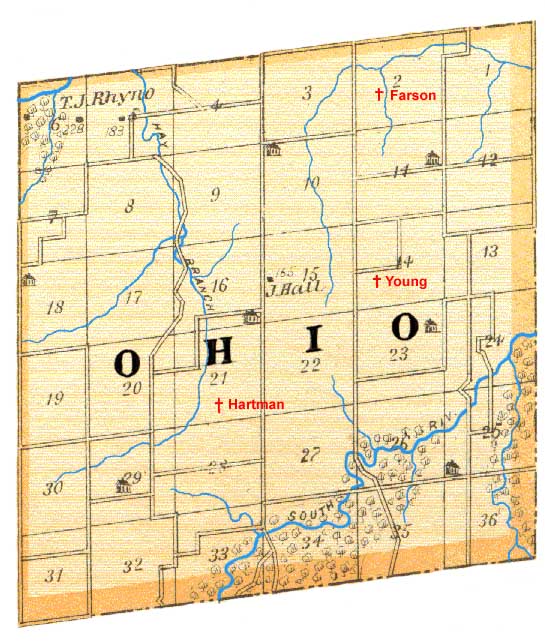
History This township is located in the southeastern corner of the county, and takes its name from the fact that many of its early settlers were from the State of Ohio, and named their township in honor of the Buckeye land. It is bounded on the east by Warren county, on the west by Walnut township, on the south by Clarke county, and on the north by South township. The surface is drained by South river and a number of small streams. The general character of the township is that of beautiful prairie land, perfectly fitted for farming purposes. Along the streams there is a good growth of timber. Back from the streams is high, rolling prairie of the richest soil. There is a plentiful supply of water, and some of the springs in this township never freeze in winter. This township was not settled until a comparatively late day. Andrew Hart and M. S. Douglas were its first settlers. They came in 1854. They were both rebels and when the war broke out, they sold out and moved South. Noah Bishop, John Cregor, Henry Cregor, Solomon Delong, A. G. Martin, William Farson, and J. D. Hartman, also settled here at an early day. Since then the township has settled up rapidly. Good schools and churches are found in this township, and the people generally are of the best class. The following are the township officers: Justices - A. J. Fansher, John Howe; Trustees - V. McPherson, Thomas Hartman, William Scott; Constable - Moffatt Cregor; Assessor - H. H. Hollinshead; Clerk - John W. Mann. The Oak Run Church of Friends was organized May 18, 1871, with the following original members: T. C. Moorman, R. A. Moorman, Mary Hiatt, E. Hiatt, David Ellis, M. E. Ellis, Calvin Ellis, E. Ellis, William Woodward, E. Woodward, J. Simmons, E. J. Simmons, W. H. Bishop, M. Bishop, Q. Pierce and Virginia Pierce. The pastors have been John Coffin and John Woods. The present building was formerly a school-house, but was purchased by the Friends for their own use. It was dedicated to religious uses in 1877. The first Friend Quakers to settle here were: T. C. Moorman, Dosha Moorman, W. N. Moorman, Jesse Painter, Susannah Painter, T. P. Moorman, Rhoda Moorman, David and Martha Ellis. Map Shown below is Ohio Township as it appeared in 1875. There were about 150 families living there at the time the map was made although only 2 are shown. The South River is the primary watershed in the south half of the township and the Hay Branch which joins Clanton Creek in the north half. Of the three cemeteries active in 1875, only the Young cemetery was shown by the map maker. The skew of the square forming Ohio Township is exaggerated by about double. |
|
|
|
Ohio Township - 1875 |
| Maintained by the County Coordinator |
|
This page was created on July 23, 2004. This page was last updated Monday, 07-Dec-2020 09:13:00 CST . |


