Early Settlements, Abandoned Towns, Villages and Communities of
Louisa County,
Iowa
(The information presented here is from a variety of sources including The Annals of Iowa, Louisa County Historical Society tour book, the 1981 Centennial Edition of the Wapello Republican, the Aug. 6, 1946 edition of the Burlington Hawk-Eye Gazette, and the 1980 Muscatine Journal special edition Louisa County: Its Towns and its People.) Compiled by Connie Street
Louisa County
|
|
|
|
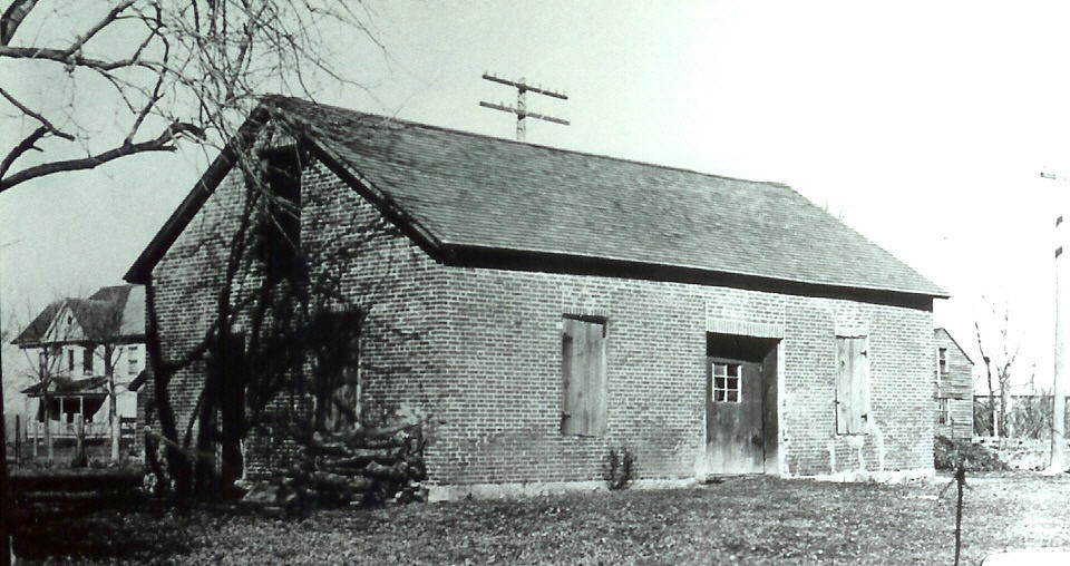
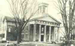
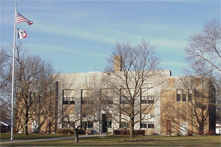
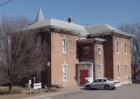
| 1840 Courthouse | 1854 Courthouse | 1929-present Courthouse |
Louisa County was created from a strip of land that was known as the Black Hawk Purchase. The earliest “white” settler arrived in present day Louisa County in 1834, when the Sac and Fox tribes were still in undisputed possession of the area. The Keokuk reserve was not ceded to the government until September 1836. Cristopher Shuck is recognized as the first white settler. He built a cabin at the mouth of the Iowa River in 1834 near today’s Toolesboro. In 1835 and 1836, a few men with their families moved into the county, among them Philip Harrison, John R. Snowden, Jeremiah Smith, William H. Creighton, Thomas Parsons, James Irwin, William Kennedy, David Morgan, H. Parsons, Robert Childers, Mr. Thompson, Mr. Milligan, Joseph Higbee, Abraham McCleary, Thomas Stoddard, Wright Williams, William S. Toole, G. Long, Levi Thornton, James H. Williams, G. R. Williams, G. H. Crow, Mr. Humphrey and Mr. Stevens. Louisa County was formed in the winter of 1836. From 1837 to 1838, Burlington, about 25 miles south of Wapello, briefly served as the Wisconsin territorial capital, and was Iowa’s territorial capital from 1838 to 1840.
The first courthouse, made of cottonwood logs, was in Lower Wapello, part of Wisconsin Territory at the time. The sheriff lived in one end of the building. It was located near the entrance to today's L.J. Thompson Park on River Road. The first court case was heard by Judge David Irvin on April 20, 1837. Early Louisa County pioneer Obediah Garrison, who died April 1906 at age 97, drove to this county in a sleigh, crossing the Mississippi River March 9, 1837. He landed on "Tater Island" (later known as Oakville) and arrived in Wapello a few days later. Mr. Garrison attended the first court session in Louisa County. He told that because there was no courtroom, one of the hollows along the Iowa river near Wapello was used. The jury room for the grand jury was in a cave on the Iowa River bank, while the petit jury met in a movable calf pen. (This might be what Mr. Garrison was remembering.) In January 1839, the Territorial Legislature of Iowa proposed that an election be held to name a county seat. Wapello was declared the county seat on March 4, 1839. One year later, in 1840, a one-story 40-feet by 20-feet brick courthouse was erected at a cost of $1,300. It was located where the Lutheran Church stands today. In 1854, a third courthouse was built on the public square facing Main Street. It measured 60 feet by 80 feet and was constructed at a cost of $9,577.69. Stone was used from a quarry located in the bluffs southwest of Wapello. Mr. Garrison helped build the 1854 courthouse. In 1927, the north wall settled, leaving a large opening on the second floor and the north wall. The building was declared unsafe. The present courthouse is located on the site of the previous courthouse. The two-story brick and stone building was completed in 1929 at a cost of $100,000. It is listed on the National Register of Historic Places. The black walnut doors to the courtroom are the same doors used in the 1854 courthouse. In 1980, an elevator was installed at a cost of $75,000. On the courthouse grounds is a 20-pound Civil War cannon made by G. E. Parrot of Notre Dame, Indiana in 1861 and other monuments to war dead from the county.
Wapello, Fredonia, Harrison and Columbus Junction had each sought the designation of county seat. Columbus Junction even constructed a courthouse building that was later used as a high school. After Wapello was chosen to be the seat of government, Columbus Junction became the home of the annual Louisa County Fair.
Settlements/Communities
At one time or another, Louisa County has had more than 50 established communities, most of which were located along the Iowa or Mississippi rivers, where river transportation was a way of life. The earliest known settler was Christopher Shuck who built a cabin in 1832 on the north side of the Iowa River upstream a ways from the Indian Village called Tecumseh. Louisa County, as a governmental entity, did not come into existence until an act of the Michigan state legislature in 1834. The census of 1836 listed 38 families in Louisa County. Townships were Wapello, Florence, Columbus City, Jefferson, Grandview and Fredonia. Later Concord and Oakland were added and Florence became Eliot.
Alimeda was laid out in July 1859 as a depot stop on the Missouri and Mississippi Railroad and is now the eastern part of Fredonia.
Altoona/Altona was the name of the post office at Hillsboro 1857-1859. A second reference gives the dates as1858-1861. (See Hillsboro and Toddtown.)
Bard was a station stop on the Cedar Rapids and Burlington Railway line in 1868, halfway between Wapello and Columbus City on the south side of the Iowa River. (See Long Creek Station.)
Big Springs, a post office 1863-1869 on the Iowa River in the northwest corner of Oakland Township.
Black Hawk was the first name for Toolesboro (see below). It may have been the site of Black Hawk's Indian village.The village was already established when the county was first platted in 1836-37. The post office existed 1837-1841. Government surveyors of 1838 said there were six or eight houses in the village. Located at T73N RO2W Sec 10 on Government Land Office maps.
Buffington Creek. The location is unknown. The creek by that name is located in northern Elm Grove Twp.
Burris City was a boom town on the Mississippi River north of its confluence with the mouth of the Iowa River. It was chartered in 1857.
Cairo had a post office established July1, 1856. The original town was laid out by James H. Marshall. It was registered June 15, 1865. There were three additions: one by J. S. Marshall in 1866 to the north, the 19-lot Van Horn and Kiner Addition to the south in 1866 and the 4-lot Van Horn Addition in 1875. A few houses still exist in this community. Although Cairo was a thriving community, it was never an incorporated town. Cairo is located in Twp74N Range4W. (See Hope Farm.)
Catteese was an early name for Port Allen. (See below.)
Cannonsburg was laid out in northern section 28, Elm Grove Twp. in 1856 by R. B. Cannon on the route of the Airline Railroad, but never grew to more than a hamlet.
Clifton was a railroad station for the Mississippi and Missouri Railroad about two miles west of today's Columbus Junction. The village was laid out in 1858 by Joseph Green and George Stone. In 1865, an addition was laid out by George Haywood. The village had 200 residents in 1870. There was a Methodist church and a Catholic church, two lumber yards, two hotels and several stores.
Columbus City was first located about one-quarter mile to the east of the current city. It was laid out by David Mortimore as proprietor. On the back of the plat, John Gilliland, surveyor/justice of the peace, certified that on June 18, 1840 Mortimore had acknowledged the map as the original plat and plan for Columbus City. The town was soon moved to the current location. Edward F. Wilson was the founder of the current placement of the city of Columbus City. The first lots went on sale July 4, 1841. The town became an overnight stop along an important early route between Burlington and (then capital) Iowa City. It was about teh half-way point between the two cities. Columbus City was incorporated in 1871, with the first elections held Saturday, May 27, 1871. Elected that day were Mayor, Abram Fulton; Recorder, Wesley W. Garner; Councilmen, H. P. May, G.L. Tomes, J. N. Smith, J. Myler and Daniel Morgan.
 |
 |
 |
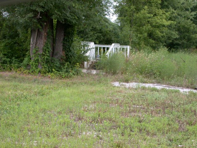
| Columbus Junction Library 2004 | Swinging Bridge 2004 | Courthouse Building |
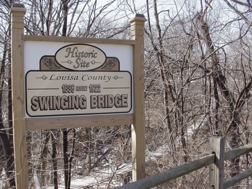
Columbus Junction is still in existence. The town was originally called Sand Bank. The first train of cars on the Chicago, Rock Island & Pacific arrived at Sand Bank on November 17, 1857. The site was the end of the road until September, 1858, when it was completed to Washington. On December 29, 1869, August Gilbert of Muscatine arrived at Sand Bank. Deciding to locate here, he returned to Muscatine, had a house framed, loaded it on the cars of the CRI&P Railroad, and shipped to Clifton station and from there had it transported to Sand Bank by horse and wagon then assembled. On February 7, 1870, the first train of cars on the Burlington, Cedar Rapids & Minnesota Railroad came to this point, and on that day the first ticket was sold to Col. W.W. Garner. On February 8, 1870, Gilbert opened a restaurant and boarding house in his new building. The town was laid out March 1, 1870 by J.W. Garner and the plat was recorded on March 12, 1870. The first lots were sold to George Jamison. A swinging bridge, first built in 1886 to cross a deep ravine between Third and Fourth streets, is the most notable and unusual attraction in Columbus Junction. Columbus Junction is also the home of one of the oldest county fairs in the state. Today the town has a large Hispanic population.
Concord, a post office 1851-1857 near the southeast corner of Concord Twp. on the Iowa River.
Cotter is still an incorporated town. It was first called New Clifton, then Cotterville.
Cotterville (See above.)
Cuba City was a prospective town of early territorial times thought to have been on the south shore of the mouth of the Iowa River. Cuba City was probably the place Lieutenant Albert Lea talked about in February 1836 when he described the only house at the mouth of the river as being "occupied by a drinking crowd of men and women" and wrote "after being refused shelter in the house at the mouth of the river, I was obliged to go up the narrow, crooked river on the ice, . . . four miles to a snug cabin on the north side." This home undoubtedly belonged to Christopher Shuck, who is regarded as the first permanent settler in the county.
East Morning Sun was established in 1870 by Josiah Nichol. It is now the eastern part of Morning Sun.
Echo has been attributed as the nickname for Oakville because of the sound of train whistles echoing off the nearby bluffs.
Elrick was laid out by Jacob W. Elrick Oct. 3, 1891 in the southwest quarter of section 28 and in Eliot Twp. It was on the east side of Smith Creek where the Iowa Central Railroad crossed. There was a post office 1883-1924. At one time the town had a population of eight to ten families. None of the early buildings remain. Today's Spring Street north of Louisa County Road H22 is where Elrick was.
Elrick Junction came into existence, like many other towns, when the railroad came through. It was laid out by H. O. Weaver in 1899 on the north side of the junction of the Iowa Central Railroad and the Muscatine North-South Railroad in Section 29 of Eliot Twp. It is located on today's F Avenue north of Louisa County Road H22. It had a general store, depot and a hotel. A few residences are still there.
Florence was a flourishing territorial town from about1838-1846 in the west section 20 of Eliot Twp. on the southwest side of the Iowa River. William Phinney opened a tavern there in 1838; Phillip B. Harrison was granted a ferry license in April 1837; John Diehl was appointed postmaster July 5, 1839. Diehl, Silas Foster and Calvin Donaldson ran stores. The town was on the site of Chief Keokuk's principal village and where the Indian warrior Black Hawk met with Keokuk shortly before the Black Hawk War began. The remains of the old Austin house still stands at the intersection of today's 40th Street and Avenue F.
Forest Hill a post office 1857-1864 in the northeastern part of Grand View Twp.
Fredonia is still an incorporated town. It was established as a ferry landing area in 1836. The village was laid out in 1836 by Alvin Clark on the east bank of the Iowa River directly below the junction of the Iowa and Cedar rivers. The first buildings were log cabins built along the river. This point on the river was a favorite trading place for the Indians of the area and in those early days hundreds at a time would gather there. 1841 the first steamer came up the Iowa River, passing the bustling trading and shipping port. In 1855, Marvil Wheelock built a grist and saw mill. The first hotel in the town was built about 1847was near the river and called the Ferry House. In 1856, the railroad reached Fredonia. By 1858, there were two hotels and Dr. Solomon Dill established his practice. Other early families included the Dillers, Careys, Curtisses, Maxsons, Wheelocks and Blivens. About 1880, the population began to shrink, but in the early 1900s there was still blacksmith shop and sorghum mill, grocery store and a two-room school. Many of Fredonia's early inhabitants are buried at the Fredonia Cemetery south of Iowa Highway 92. It remains in existence.
Garden City was established in 1916 as a vegetable market settlement northeast of Grandview on the Missouri and Mississippi Railroad.
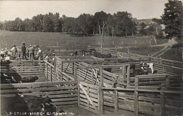
| Gladwin, established in 1903, was on the south side of the Chicago, Milwaukee and St. Paul Railroad. It was located where today's Louisa County roads X17 and G26 meet 215th Street, on the bank of Goose Creek. Its peak population was 45. The town was reportedly named for Win Blanchard who was glad to learn a town was to be built there. Jim and Lottie Jones owned one of the first stores in Gladwin. A few houses remain today. |
 |
 |
| Gladwin Stockyards |
Gladwin 2006 |
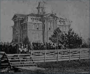
Grandview remains an incorporated town. It was the site of a post office as early as 1838. The town was laid out by Alvin Clark and Robert Childers and surveyed by John Gilliland in 1841. It was home to the Grandview Seminary of Learning, built in 1843. The name was changed to Grandview Normal Academy about 1856, then Eastern Iowa Normal School in 1875. The building was torn down in1922 and the city park, named Academy Park is located on the site. Many of the town's early settlers were German immigrants. A railroad from Muscatine to Elrick Junction was built in 1896 and passed through the eastern portion of Grandview. Mrs. Jim Buster, a young mother from Grandview, burned to death in a train wreck at Hahn's Crossing (Muscatine Island) on Dec. 4, 1919. Two Wapello passengers were badly burned, but survived. The Muscatine, Burlington and Southern Railroad became known as the Murder, Burn and Suffocate Railroad afterward. The town is still in existence.
Harrison, another river port, was laid out with
the intention of being the county seat. The
Louisa County Board of Supervisors met in the town in 1837, however, there is no
extant record of the original plan or plat of the town. It was populated by 1838 on the northeast
bank of the Iowa River and about a mile and half northeast of Wapello.
The town was laid out in 1841. It had a post office 1840-1857. The earliest record
is in an old plat book that says:
“This town re-surveyed and laid out by William Kennedy is situated on the east
side or left bank of the
Hillsboro was located about three-fourths of a mile north of the business section of Columbus Junction along the west bank of the Iowa River adjacent to a ferry landing. It was laid out in 1842 by William Todd. It was also called Toddtown and the post office, 1857-1859, was Altoona. (See Toddtown.)
Hope Farm, located in Marshall Twp., was a small hamlet with one store and a few dwellings. The Hope Farm school was built about 1837. Samuel Isett was the first postmaster, appointed February 22,1840. The Hope Farm post office was discontinued March 23, 1856. (See Cairo.)
Indian Village - the largest in the county - was occupied when the first plat books of the county were issued. It was located on land along Otter Creek in the north half of the northeast quarter of Section 1 of Township 73.
Iowa Town was one of the earliest trading posts in the county. It was probably located in Section 27, Twp.73N, Range 2W, just west of the Iowa Slough. At the first term of court in April 1837, Rufus P. Burlingame procured a license to run a ferry across the river at Iowa Town. He also operated the first store in the county. The first tavern license in the county was in Iowa Town and was granted July 11, 1837. About the same time, William DuPont was granted permission to build a bridge across the Iowa Slough on the road to New Boston. Iowa Town disappeared soon afterward.
Lafayette was laid out in May 1856 south of Hillsboro and on the north side of the Missouri and Mississippi Railroad. It is now a part of Columbus Junction.
Lettsville was established as a railroad town in 1855 by James A. Green on the Missouri and Mississippi Railroad. The depot east of the town was known as Ononwa. (See Ononwa.)
Letts evolved from Lettsville and still exists.
Linton was a farm south of Newport used as a post office in the mid-1800s.
Long Creek Station was located at or near Bard. (See Bard.)
Louisa Center was the location of a country school about one mile north and six miles west of Wapello. A Baptist Church was begun there in 1877, with services held in the school until a church building was constructed in 1904. The Woodruff and Morgan families were the nucleus of the community.
Marsh was located where today's S Avenue meets 30th Street. It was established in 1884 on the north side of the Iowa Central Railroad tracks about half way between Morning Sun and Winfield. A post office operated from about 1884 to 1925. There was a stockyard, depot, an elevator, vehicle-repair garage, church, scale house, small store and a general store where the post office was located. J.F. Leeper was one of the postmasters. Ronald Dold was one of the store keepers.
McKean's Landing was a ferry landing near today's Hoben Bridge is located in Oakland Twp.
Mid Prairie was a post office in the northwestern part of Morning Sun Twp. from 1863-1877.
| Morning Sun was laid out by Cicero Hamilton September 13, 1851. |
Mount Sterling. Same as Sterling. (See below.)
New Clifton, first name for Cotter. (See above.)
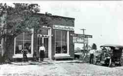
| Newport was laid out in 1885 by Harriet H. Briggs along the Iowa Central Railroad. It was located where today's U.S. Highway 61 (then called the Wapello Road) intersects with Louisa County Road H22. In this photo: storekeepers Ike Vaughn and Charles Humphrey and boys, Delbert Hamilton, Dwight Baird and Walter Dotson |
|
Newport |
Oakland was a settlement in Oakland Twp., established in 1854 on the west corner of Section lines 25 and 36. The post office was called Port Allen.
Oakville was laid out by Abe and Harry Parsons Dec. 11, 1891, south of where the Iowa Central Railroad and the Missouri St. Paul Railroad crossed.
Odessa was laid out in 1861 on the northwest edge of Lake Odessa, Sections 7 and18, Twp. 74 by M.P. Vanloon. The streets were Pork, Water, Second, Third and Fourth streets running north and south. East and west, the streets were alphabetical A to H streets, with Commercial Street in the center of the town. Big river boats once tied up when landing at Odessa in the 1860s at the foot of D Street, which ran along the lake.
Ononwa was a depot of the Missouri and Mississippi Railroad. The community around the depot became the town of Lettsville. It is incorporated into the eastern part of today's Letts.
Osceola Hill, is the name of the 100-foot high bluff overlooking the Iowa River north of today's Columbus Junction.Small bands of Sac and Fox Indians traded there as late as1870. This place where their ancestors were buried. It is west of Hillsboro and the Rock Island tracks. William Todd began a town called Toddtown in 1838. The Todd House Hotel stood there until the mid-1980s.
Palo Alto was a small town located one-quarter mile south of today's Oakville. It consisted of a post office, several houses, a church, and a school. Oakville was laid out December 11, 1891, where the Iowa Central Railroad and the Missouri St. Paul Railroad crossed. The Railroad was the demise of Palo Alto.
Pitchin was a community located three miles west and one-quarter mile north of Cairo in Section 23 of Elm Grove Twp. on today's 95th Street. The Spring Run Cemetery is located there. (See Spring Run.)
Pittsburg. Exact location unknown, but would have been somewhere between Harrison and Catteese.
Port Allen was laid out in 1841 on an island at the fork of the Cedar and Iowa rivers. It was also known as Port Island and the "garden of the West". A ferry operated there to cross the Cedar, and a second ferry crossed the Iowa.
Port Island. (See Port Allen.)
Port Louisa was south of the cutoff of Muscatine Slough in Section 5 of Port Louisa Twp., surveyed in 1854 by John R. Sisson. It was adjacent to West Port. Also known as Wallings Landing, it was an established shipping port on the Mississippi River prior to the advent of railroads. The streets were fifty-feet wide to accommodate heavy traffic. The east-west streets were named Washington, Main, Taylor, Jefferson, and Madison. The north-south streets were Water, Second, Third, Fourth and Fifth streets. The pumping station, at the north entrance to the Port Louisa National Refuge, sits today at what was once the corner of Washington and Water streets. There was a post office 1847-1875. In 1854 there was a steam saw mill and steam flouring mill and 75 building lots. (See Walling's Landing.)
Port Washington was laid out by William Hardin and William Johnson on the bank of the Mississippi River and surveyed by A.D. Hurley in 1848 in Section 8 of Port Louisa Twp. on the Mississippi River. An early plat of the town showed it consisted of 12 blocks. The location would be east and about a mile north of Grandview.
Salzertown. Unknown location.
Sand Bank was the original name of the site where Columbus Junction is located.
Sterling was platted on the west bank of the Iowa River by Franklin Bass and in 1856 was added to the the town of Toolesboro. It is sometimes referred to as Mount Sterling.
Spring Run was another name for Pitchin. The Spring Run church is located on today's Louisa County Road X17 about one mile north of County Road G62 in Elm Grove Twp. The Spring Run Cemetery is located where a community known as Pitchin was situated. There was a post office 1852-1865. (See Pitchin.)
Tecumseh might have been an early name for Toolesboro or located nearby. Exact location unknown.
Todd's Landing was the forerunner of Fredonia. It was a place where barges were built.
| Toddtown was north of Columbus Junction along the river. (See Hillsboro and Osceola Hill.) | 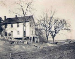 |
Toolesboro, located on today's County Road 99 north of Oakville, was first called Black Hawk and possibly Tecumseh. The town was later named for William L. Toole who was a member of the Territorial Legislature when the county was established. It was first spelled Toolesborough in 1837. The city was the first place settled in the county and for many years was the manufacturing and commercial center of the county. Toole was the postmaster in 1837, replaced by Elisha Hook in 1838. In 1839, the first school in the county was opened and the teacher was John. W. Ferguson. There remains a small community at the site. In 1844, the flourishing town boasted of two distilleries, three mills, stores, a warehouse, the first school in the county and the Toolesboro Manufacturing Co. John Dennison had a business manufacturing crocks there in 1846.
Twin Oak. A post office in the southwestern part of Section 20, Oakland Twp., 1873-1881.
Virginia Grove was first settled by Joseph and Rachael Higbee in the northern part of Morning Sun Twp. It became the official post office for Morning Sun and Virginia Grove 1813-1871. W.B. Brown was the post master in the 1830s. Twenty-seven voters took part in the 1839 township elections at the Guinn residence. The original community was located in Sections 9,10,11,14,15,16, 22, and 23, Township 73. When the railroad came through Morning Sun about three miles to the southeast, the Virginia Grove post office was moved there. A school building remains and is located in a county-owned recreation area located on today's 55th Street west of Q Avenue. There is also a Virginia Grove Cemetery nearby.
Walling's Landing was a pioneer settlement and river landing where Port Louisa was later established in 1854. It was a major shipping port with two mills prior to the advent of the railroad. (See Port Louisa.)
| Wapello, the county seat, had only five or six log cabins and a store in its earliest settlement. It was at first divided into three sections - Lower, Central and Upper Wapello. The Louisa County Agricultural Society held a fair, the first in the state, on the north edge of Wapello in October 1853. The town was incorporated and became a charter city in July 1856. The city is named for an Indian chief named Wapello who is believed to have had a camp along the river near the south end of the city. |
West Keithsburg. East of Oakville, near the
Mississippi River. (Map courtesy of Frank Mauer)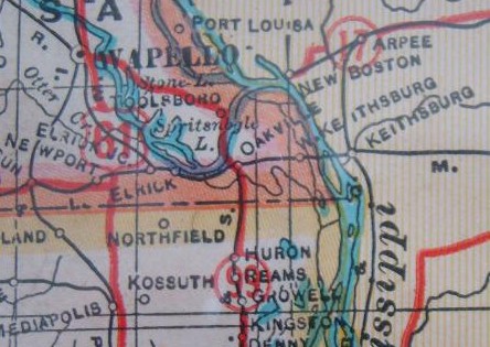 |
West Port Louisa was platted by Henry Rockafeller/Rockafellow in 1849 and was located in the northwest quarter of the northeast quarter of sections 6 and 7 in Port Louisa Twp.
Wyman was incorporated in 1879 as the only town in Elm Grove Twp. It was settled in 1839 and in 1881 had the only depot for the narrow gauge Burlington and Northwestern Railway in Louisa County.
Yankee Town. Location unknown.
Yellow Banks was probably situated on the north side of the Iowa River near where the Oakville bridge is today. Early settlers claimed there was a French trading post at that location long before the Black Hawk War.
Page updated April 20, 2014
Back to Our Towns and Communities Index