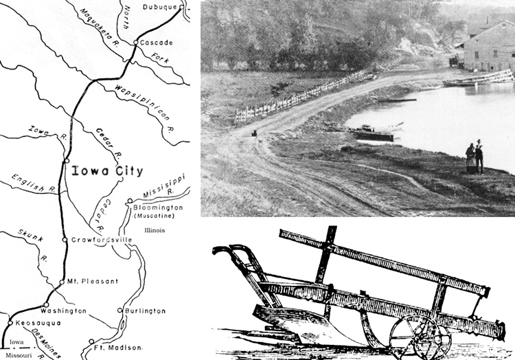
From
Dubuque through Iowa City to Keosauqua near the Missouri border, the first
federal aid highway in Iowa was marked
by plow in 1839 when no roads existed.
North Riverside Drive in Iowa City remained a treacherous mud trail into the
1920s.
|
By Bob Hibbs
A
$20,000 federal appropriation in March 1839 funded Military Road from
strategic Dubuque through Johnson County where site for a territorial capitol
would be designated two months later, then southwest to the Missouri border
near Keosauqua.
Congress
was encouraging construction of roads on the frontier, a characterization
which certainly fit the county where a site for Iowa City would be picked in
early May.
The
few dozen settlers already in the county were mainly along the Iowa River
south of what is now Iowa City, surrounding a pioneer trading post designated
Napoleon. That was where Dubuque legislator Chauncey Swan was to meet
legislative colleagues John Ronalds and Robert Ralston on May 1.
They
were to choose a site for Iowa City, which Swan and Ronalds accomplished on
May 4 to the subsequent acquiescence of Ralston. They marked the spot for a
capitol on what is now the University of Iowa’s Pentacrest Campus.
At
first called Military Road, it soon carried the moniker National Road. In Iowa
City, it ran along what now is Jefferson Street beside Pentacrest. Here Swan
and his wife, Dolly, would run what first was named National Hotel after the
roadway beside it, later called Swan’s Hotel.
It
occupied the northeast corner of the Jefferson-Capitol intersection, a site
now serving Gilmore Hall.
Soldiers
planned, surveyed and supervised construction of the route which entered Iowa
City along what now is Highway 1, except that it followed Old Dubuque Road and
crossed the countryside west of the current Interstate 80 overpass. It crossed
the Cedar River near Ivanhoe Bridge.
Generally,
it followed what now are Highway 1 to Anamosa and Highway 151 to Dubuque.
But, south of Iowa City it was located well east of present Highway 1
to Washington and Keosauqua.
The
entire length has been rebuilt, straightened and widened, leaving little of it
on the exact original alignment.
The
ink on the 1839 appropriation bill was hardly dry before the section between
Iowa City and Dubuque was being surveyed under direction of the U.S. Army.
When that was complete, a contractor named Lyman Dillon was hired to mark the
route to guide work crews.
Using
a sod breaking plow, he plowed a furrow 100 miles between the strategically
important lead mines at Dubuque and the new capitol of Iowa Territory. As the
first dirt was moved at Old Cap, dirt also was being moved for
Military/National Road.
As
Dillon finished, crews were cutting trees and brush in a 40-foot wide swath.
Tree stumps were grubbed out by oxen; ditches were dug to drain wetlands; even
some bridge abutments were built of stone.
Mostly,
though, creeks and rivers had to be forded during several subsequent decades;
but, the initial layout included marking the best sites for bridges and
ferries.
The
military actually made little use of the road, but give it its name.
It
became an important thoroughfare for pioneer families west bound from Chicago
to the frontier capitol in Iowa City. Many other families, of course, arrived
from Muscatine and Davenport, having taken a steamboat up the Mississippi from
St. Louis, or more distant points.
But,
arrive they did. From its beginnings in 1839, the permanent population of Iowa
City topped 5,000 in just 20 years.
An
“Old Military Road” marker at Dubuque notes it passed from that city
through Cascade, Monticello, Langworthy, Anamosa, Mt. Vernon, Ivanhoe, Solon,
Iowa City, Ainsworth, Crawfordsville, Mt. Pleasant, Hillsboro and Keosauqua.
Indeed,
as the state’s first federal aid highway, it opened the way in both
directions to Iowa City. Next
Saturday:
Flu kills 38 in Iowa City.
Bob
Hibbs collects local postcards and other historic ephemera and researches
history related to them. |