By
Bob Hibbs
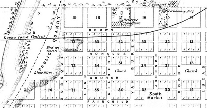
The
quarry feeding construction stone to Old Capitol, a phantom railroad and empty
church preserves along Church Street were dominant features of Iowa City’s
original north side.
It
also boasted a substantial early house called “Prospect Hill” at the north
end of Johnson Street, residence of Hugh Downey, pioneer attorney, real estate
agent and partner in the first local banking firm, called Cook, Sargent and
Downey which occupied what is now the Iowa State Bank corner downtown.
Downey,
for whom a Cedar County community is named, also helped found the first local
commercial club and the first literary guild. He also was active in an early
movement to build a public library, served as a territorial legislator and
later as an original trustee of the University of Iowa.
The
still-existing Prospect Hill house, built about 1844 and perhaps occupied as
early as 1842, also carries the unsubstantiated claim of being designed by
architect John Rague, who at least in part designed Old Capitol.
A
Lyons Iowa Central Railroad route through the north side was never completed,
although a roadbed was built from the Iowa River east some 70 miles into
Clinton County at the Mississippi River. Bankruptcy occurred before rails were
in place or an Iowa River bridge built, stranding dozens of unpaid worker
families in Iowa City.
Two
church preserves platted along Church Street by city founder Chauncey Swan in
1839 never served churches. However, the half-block-sized parcel at Dodge
Street was given to the Presbyterians by the state legislature meeting in Old
Capitol in 1855.
That
congregation had set a cornerstone for its Old Brick Church in 1856, but lack
of money prevented serious construction even though the Church Street plot was
sold to help pay for Old Brick, finally occupied in 1865. The sold-off site
eventually served Aldous Greenhouse, Eagles grocery, and currently Lenoch and
Cilek Ace Hardware.
North
Market was one of three such square blocks set aside in 1839 for local farm
commerce, now all in other uses. This northerly of them is the park adjacent
to Mann Elementary School.
The
“Public Quarry” and “Bird-eye Marble” labels on an old Millar
promotion map refer to historic use of stone for construction of basement
walls, including those for Old Capitol, and for local crafts produced by
entrepreneurial artisans.
Early
residents crafted paperweights, cane heads and novelties from local
coral-bearing limestone which “would take a fine polish,” according to an
1870 Geological Survey report. The stone was called bird-eye marble despite
being limestone, not marble.
The
fossilized corals occur in world-famous quantities in what geologists call the
Cedar Valley Formation, a 30 to 40-foot thick sedimentary rock layer of
350-million-year-old Devonian deposits underlying the local area.
When
the first dam of the Iowa River was built upstream from Iowa City, the tiny
village at the site took the coral name of the bedrock on which the dam was
built; thus, Coralville.
The
“Cedar Valley” strata name has on occasion resulted in the mistaken belief
that part of the stone for Old Capitol came from a Cedar Valley quarry. Even
the 1920 Old Settlers Association yearbook carries a tale of stone ostensively
for Old Capitol being ferried across the Cedar River near what is now the
Highway 1 crossing.
Rather,
that limestone may have been for the historic Stone Academy north of Solon
since stone for Old Cap came from the Cedar Valley Formation at two sites
along the Iowa River, one in Iowa City, the other from State Quarry located in
what is now the first cove downriver from the Mehaffey bridge between North
Liberty and Solon. Thus does a bit of history flow from tertiary review of a 150-year-old map of Iowa City’s north side. Next
Saturday:
Exploring old east Iowa City.
Bob
Hibbs collects local postcards and researches history related to them. |