Saturday
Postcard 218: Local Map Shows Minnehaha & Clarksville
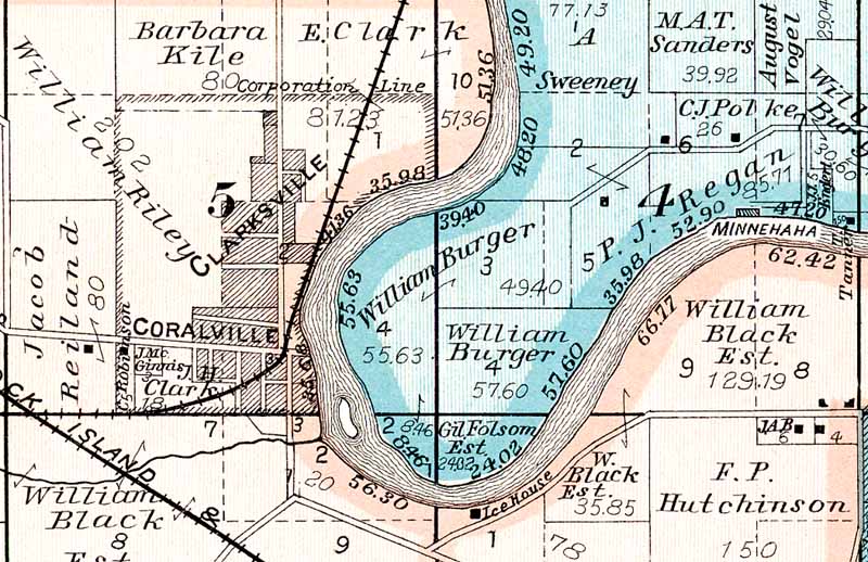
Coralville and northwest Iowa City highlight a section of a century-old township map which focuses on the Iowa River loop
located between today’s Rocky Shore Drive in Iowa City and First Avenue in Coralville. Note a “Minnehaha” label in the
river near the east (right) edge, and the “Clarksville” label above Coralville.
|
By
Bob Hibbs
Local
history lurks in the lines and labeling of a 1900 map showing Minnehaha along
the Iowa River across from today’s City Park and the existence of both
Clarksville and Coralville upstream.
The
map depicts a block-long island in the river opposite the mouth of Clear
Creek, but doesn’t display the historic 1843 Coralville dam then located
just a block upriver from the island. Other delightful discoveries follow as
one explores the historic treasure.
“Ice
House” labeling stands out along the river near the bottom center of the map
along a rural road now called Rocky Shore Drive connecting to what is now Park
Road. The ice house site is near what is now be the intersection of Rocky
Shore Drive with Highway 6 and Hawkins Drive.
Absent
from that is the Crandic Railway right-of-way which was purchased in 1903 for
construction of that venerable “Interurban” connection to Cedar Rapids via
Coralville, Oakdale, North Liberty and Swisher.
The
Rock Island route clips the map’s lower left corner, and its spur to the
north shows to the Coralville mills and beyond. Among others, the spur served
Jacob Hotz, a prominent contractor a century ago, who cut river ice at
Coralville and shipped it to Silvis, Ill., where it was used to pack
refrigerator cars on national routes.
Hotz
may have served residential customers from the “Ice House” showing on the
map; but, more probably it was an early location for the Englert Ice Company
which later operated its main storage facility at Brighton Beach across the
river from City Park.
The
map displays identically-sized labeling of both Coralville and Clarksville.
The latter was named for prominent Iowa City banker Ezekiel Clark,
brother-in-law to Samuel Kirkwood. Clark enticed Kirkwood to Iowa where
Kirkwood blossomed in politics as governor and U.S. senator.
Kirkwood,
an Illinois lawyer and friend of Abraham Lincoln, successfully managed the
Coralville flour mill which had been built by Iowa City founder Chauncey Swan
and others. It was closed as a failure before being acquired by Clark and
Kirkwood.
Another
Iowa town called Clarksville with a post office precluded the Clarksville near
Coralville from getting a postal facility, so it eventually was annexed into
Coralville and the name died locally. The first Coralville post office sat on
a site now in the First Avenue right-of-way near its intersection with Fifth
Street.
Coralville
became a municipal corporation in 1873 and included the Clarksville
subdivision within its boundaries, just as “East Iowa City” was absorbed
by Iowa City several decades later.
Like
Clarksville, the Minnehaha subdivision name died. It had been platted in the
19th century on the north bank of the Iowa River just upriver from what became
the northerly reaches of City Park. The surrounding farm was owned by P.J.
Regan, a prominent Iowa City nurseryman.
On
his farm Regan built the first local golf course – now part of the Elks Club
course – under an 1899 lease, which may make it the oldest American golf
course west of the Mississippi. For $500 Regan agreed to build and maintain a
nine-hole course for a newly-formed “Iowa City Golf Club” for use during
the 1900 season.
He
also agreed to move an existing farmhouse to the Minnehaha site for use as a
clubhouse with “lavatories and water supplied thereto.” The golf course
was purchased by the Elks in 1947 for $20,000.
The
Hutchinson farm at the southeast (lower right) corner of the map became part
of what today is the Manville Heights neighborhood in northwest Iowa City.
Bert Manville bought the Hutchinson farm and put it to use as site of the
first local Chautauqua in 1906. Residential development began in earnest the
following decade.
Scanning
an old map helps one pull together the flow of history spanning many decades. Next
Saturday:
Streetcars roam Iowa City. Bob Hibbs collects local postcards and researches history related to them.
|