Saturday
Postcard 217: Visiting a 1900 Iowa City Map
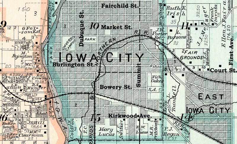
A
1900 map of Iowa City yields some interesting historic features,
including a community called “East Iowa City”
and a precise route of the old “Plug Line” railway. Historic names
abound on the section of map from a 1900
Johnson County atlas. The author added the several street names to
assist interpretation.
|
By
Bob Hibbs Exploring a 1900 Iowa City area map produces a
sense of walking in a history book as one ambles off on a journey of
discovery among its lines and lettering. One begins with orientation: There is the
“University Campus.” It certainly isn’t the dominating central feature
then that it now represents in central Iowa City. It’s just today’s
Pentacrest Campus labeled as the whole of the University of Iowa.
Enrollment in 1900 was only about 1,350. A block east (right) the eye lands on a
two-square-block area labeled “Park,” an obvious cartographer’s error
since old downtown city park occupied only one square block bounded by
Dubuque, Iowa Avenue, Linn and Jefferson streets – directly south of
today’s First Methodist and St. Mary’s Catholic churches. Iowa City gave the park to UI in 1890 to stave off
talk in the Iowa legislature of moving the university nearer the center
of the state. The other block served 1842 Mechanics Academy with
frontage along Linn Street between Iowa Avenue and Jefferson Street
that was a half-block deep originally plated in 1839. The east half of
that block, facing Gilbert Street, had been sold as lots, but by 1900
had been acquired by UI as hospital space. A block west (left) of “University Campus” features
a three-block area west of Madison Street labeled “P-A-R-K.” In 1839
founding father Chauncey Swan labeled it “Promenade,” a hoped-for
landing site for steamboats. A relatively few paddle-wheelers ever
plied the river upstream to Iowa City. The university put the area to use for baseball and
football games, developing it as “Athletic Park” where
standing-room-only crowds reached 25,000 before Kinnick Stadium was
opened in 1929 with 45,000 seats. The area between Burlington Street
and Iowa Avenue now serves the UI Water Plant and English-Philosophy
Building. As one scans farther from the central area, the eye
picks up “East Iowa City” in the southeast (lower right) corner of the
map. It was a large subdivision which in 1900 was unincorporated – like
River Heights north of Iowa City today – where the W.F. Main jewelry
manufacturing plant had been built, along with surrounding home lots. The existence of East Iowa City as a separate town,
although never incorporated, explains why First Avenue today is farther
from central Iowa City than Seventh Avenue, a seeming inversion of the
usual order of things. Developers expected East Iowa City to grow east,
making First Avenue its central thoroughfare. Instead, the subdivision
was annexed into Iowa City, and East Iowa City died. Just west (left) of East Iowa City one sees the
Rundell farm, developed beginning in 1910 as a subdivision flanking
Ralston Creek served by the first street cars from downtown, done to
promote subdivision lot sales. The dominating railroad loop from downtown into
East Iowa City is the “plug line” owned in 1900 by the Burlington Cedar
Rapids & Northern. Its depot was along the bank of Ralston
Creek in what is now a parking lot behind the Recreation Center
downtown. Along the plug railroad, the eye catches “Fair
Grounds” labeling just east (right) of the tracks in what today is the
Morningside Drive neighborhood below City High School. As City High was
developed during the 1930s, this site yielded to housing as the current
fairgrounds south of the airport came into being. As the eye runs along the bottom of the map, it
picks up “Mary Lucas” labeling of the Plum Grove property. She was
widow of the first governor of Iowa Territory, Robert Lucas; the site
now a state historic landmark. Such historic name as Coldren, Ryerson, Clearman,
Williams, Hill, Butterbaugh, Mahoney, Elliott, Crowley, Slavata,
Boarts, Oakes, Pritchard, Fairall, Kelly and Oakes surround Iowa City. It’s fun to explore 1900 Iowa City. Next Saturday: Another local map shows towns
of Minnehaha and Clarksville. Bob Hibbs collects local postcards and researches history related to them. |