|
Instructions to George B. Sargent
Surveyor General of Public lands in the State of Wisconsin and
Iowa &c. in reference to establishing, running and marking the
Northern boundary of the State of Iowa. (In copying, we have
followed the punctuation, capitalization, spelling, etc., of
the original documents.—Editor.)
By the act of 3rd March 1849 entitled
“An act to cause the Northern boundary of the State of Iowa to
be run and marked,” it is provided, “That the Surveyor General
of Wisconsin and Iowa, under the direction of the Commissioner
of the General Land Office, shall cause the northern boundary
of the State of Iowa to be run and marked, and suitable
monuments placed thereon; and the said Surveyor General shall
return one copy of said survey to the General Land Office and
another copy to the Executive of Iowa to be deposited in the
Archives of said State.”
The act of 4th August 1846 “to define
the boundaries of the State of Iowa,” &c. establishes the
northern boundary of that State on the parallel of forty three
degrees and thirty minutes (4~3° 30') north latitude,
extending from the middle of the main Channel of the Big Sioux
River, to the middle of the main channel of the Mississippi
River.
The many important considerations which
are wrought up with the critical ascertainment of such a
boundary-the evils political and Social naturally incident to
uncertainty as to County and electoral limits, —the liability
to double taxation of the citizens residing on the debatable
fields, —-the hostile feeling likely to be engendered and to
lie smouldering in the minds of the settlers within and near
to such contested grounds, and ever ready to break out into
some overt act destructive of the public peace, —all of which
evils we know, have occurred and therefore, from similar
causes, may be expected to occur again, —together form
so many admonishing reasons to the Department why a line which
is to satisfy hereafter two great States should now be
determined, under the law, by the most efficient astronomical
data, affording results, the evidence of which both in the
Field and on the Record, shall stand the test of all scrutiny,
and place the subject beyond cavil and doubt for all time.
Therefore it is the direction of the Department that the
parallel of latitude aforesaid be ascertained and established
on the ground by a series of celestial observations to be
taken under your direction, at intervals of not more than
thirty miles apart. At each point of observation some suitable
and distinctive memorial will be set up (to be cited in the
notes) and therefrom will the guide line be established in its
course from station to station, where such observations will
be taken-and the Deputy Surveyor to be appointed for that
service, shall be directed where to, and you will, run the
true line of the parallel, as your observations shall
determine; and such offsetted distances are to be most
accurately measured, and the measurements shall be set forth
in the notes of survey; and as the terminating points of such
offsets will indicate the position of the true line, some
distinctive monument is to be established at each.
The position of the line at its
connection with the Mississippi River has been ascertained by
astronomical observations, and will be maintained as
established by Capt. Lee. You will extend to the true line the
Range line from below which will intersect the same at the
point nearest to the River, and upon such Range line, so
continued, you will plant the usual mile and half mile corner
boundaries, and at such point of intersection, (which would
seem to be the North East corner of township 100 of Range IV.
West of the Fifth Principal Meridian, likely to be made a
fractional township by the true line) a corner boundary for
the township is to be set, which will be the starting point
for the measurements on the State line to the East and West
thereof. And having planted the necessary corners between such
intersection point, and the monument on the Mississippi River,
you will thence proceed Westward on the true line, from
station to station, as ascertained and determined by the
astronomical observations, measuring the necessary offsets and
measuring and marking the true line, and establishing thereon
the Township corner boundaries at intervals of six miles,
those for the sections at intervals of one mile, and those for
the quarter sections at intervals of a half mile. By these
operations the parallel aforesaid will become a correction
line, and eminently so, and whereon it is designed that the
surveys proceeding from the 3rd Correction line, already begun
below shall close by Course lines on the corners to be
pre-established on the parallel. Double corners on the
Parallel will thus be avoided, and in as much as the 3rd
Correction line is less than the length of two townships from
the Parallel, the meridional convergence is small, and there
is no conceivable reason why double corners should be made
thereon. That line will prove the best possible basis for all
the surveying operations hereafter to be undertaken on the
North of it, and the effect of so closing on it the surveys
from below, will be to make fractional all the series of
townships numbered 100 next below, and to start from it
hereafter a series of full townships to be numbered 101, in
continuation.
Looking into the future, and that not
very remote, when the Parallel of 43° 30' will have to be
continued and elongated as the great practical surveying Base
for the vast public domain North of it and far to the West of
its present terminus at the Big Sioux, the Department esteems
it a matter of no little public moment, that the most critical
methods of determining terrestrial positions from celestial
data should be adopted in prosecuting this work, and that the
means of arriving at the practical results should be spread
forth in a separate paper,—the results themselves being shown
on the Plat and Report as to the guide line, and which will
also shew the ofsets therefrom. They should be in duplicate
and should further shew the true line, the Township, mile and
half mile corners thereon, the crossings of streams, the
character of the soil, timber and general topography of the
country on the
line, and in its immediate
neighborhood.
The best modes of marking the line in
the plainest and most distinct manner, will have to be
determined in some measure by the character of the country
over which it passes. Where the country is densely timbered,
the trees immediately on line are to be uniformly marked by a
distinctive chop facing the line; and when the tree is cut by
the line a chop to be on the East and West sides of it; and
the trees within five feet of the line on each side are to be
blazed on the sides facing the line.
Where wood is used for the corner
boundaries the most durable kind of timber must be taken for
the purpose; and the posts for the township corners must
square six inches, and those for the section and half section
corners must square four inches, protruding from the surface
two feet, and extending beneath the surface two and a half
feet at least.
Where timber is not to be had mounds of
earth or stone must be constructed around posts denoting what
they stand for in the usual method. Mounds of earth are to be
conical, 3 feet high for township corners—and 2½ feet high for
all other corners. The mound to be surrounded by a
quadrangular trench of 6 feet side for township mounds, and 5
feet side for all others. The trench to face the cardinal
points, and a pit wherefrom the earth is taken to construct
the mound is to be dug on each side of the trench according to
the diagram furnished.
At the termination of the line on the
Big Sioux, it is desirable to have its position indicated, if
practicable, by an iron post similar to that on the
Mississippi, but if such
a monument cannot now be carried there, then by a Stone
Column, three feet high above ground, or one of hard and
durable wood of the same elevation sixteen inches square with
a pyramidal head, —the monument to be sunk four feet beneath
the surface.
| |
|
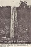 |
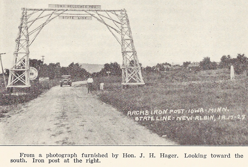
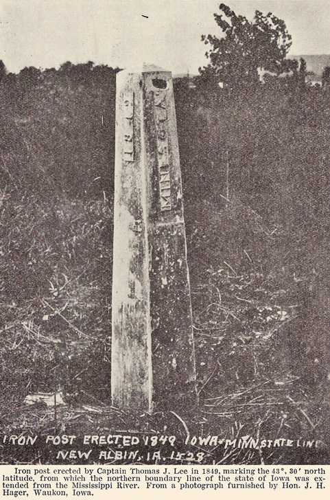
This iron post set by Captain Lee
marking the beginning of the northern boundary line of
our state stands near the north edge of the town of
New Albin, Allamakee County. From Senate Documents,
Thirty-third Cong., First Ses., 1853-54. Senate Doc.
10, p. 4, we quote: “In abstract of payments made by
Captain Thomas J. Lee, on account of expenses incurred
in establishing the initial point of the northern
boundary of the state of Iowa, and erecting a monument
thereat near the Mississippi River, we find that on
October 18, 1849, he paid A. Dowling $57.00 for cast
iron monument.”— Editor. |
| |
|
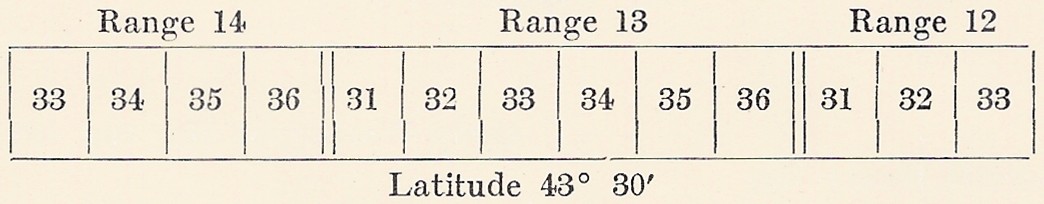
The Posts at the corner of every fourth
township or twenty fourth mile of the line from that township
corner whence the township lines will be started, will have to
be distinctive in their formation, and be set diagonally in
the ground, with two sides facing the State they indicate, the
word, “IOWA” to be deeply cut or branded on two sides, and the
word “MINNESOTA” on the other two, and “43° 30' north” below
each word, —and the same kind of marks will be made on the
monument to be planted on the Big Sioux.
The other Township Posts, (those
intermediate between the Posts at every twenty fourth mile)
and also the sectional Posts along the line are to be marked,
in addition to the ordinary descriptions, with the initials
I.B. cut or branded below the township or sectional
designation on the Iowa side, and on the other the initials
M.B.
At the intersection of the boundary
with the Big Sioux in order still more prominently to
designate the boundary point, four other posts distant
therefrom ten feet each way conforming with the Cardinal
points are to be set diagonally in the earth, making the
boundary point the centre; each of such posts to be eight
inches square, three feet above ground and three feet in the
ground, surrounded by a mound five feet in diameter, and two
and a half feet high, and outside of all is to be a
quadrangular trench a foot deep, with the earth piled up on
the inside so as to form a regular elevated margin, which
margin and the four mounds are all to be covered with sod.
Thus will the parallel of latitude
designated in the act referred to become distinguished by the
township, mile, and half mile corners, and be as effectually
defined as could be desired, by its identification with the
lines of public surveys.
A Copy of the Instructions furnished to
Captain Lee of the topographical Bureau for his direction in
establishing the initial point, together with the Report made
by that officer, will be furnished to you together with any
further instructions which shall be deemed necessary.
| |
|
General Land Office
February 2d, 1852
J. BUTTERFIELD
Commissioner
To George B. Sargent, Esq.,
Surveyor General
for Wisconsin & Iowa
Present
Surveyor Generals Office
Dubuque March 1852
To Captain Andrew Talcott
Sir.
Herewith you will receive for
your guidance in the survey of the Boundary between
the State of Iowa & Territory of Minnesota, the
following named documents, Viz:
Sketch, of the vicinity of the
intersection of the parallel of 43° 30' North Latitude
with the Mississippi River.
Copy, of the report of Capt.
Thos. J. Lee of the U. S. Topgl. Engineers, of the
computation of the observations made under direction
of Col. Abert to ascertain the intersection of the
parallel 43° 30’, North with the Mississippi river.
Copy, of the “Report of Capt.
Lee,” addressed to Col. Abert in reference to tracing
the said parallel, and to which your attention is
particularly directed.
Copy, of instructions to Capt.
Sitgreaves for running the boundary between the Creeks
& Cherokees, and three copies of the printed
instructions prepared for the use of Deputy Surveyors
in this district.
The Act of 4th of August 1846
“to define the boundaries of the State of Iowa &c”
establishes the Northern boundary of that state on the
parallel of 43° 30' north latitude extending on said
parallel from the middle of the main channel of the
Mississippi River.
To establish this line beyond
all cavil and doubt, it has been determined that the
parallel aforesaid shall be ascertained and
established by a series of Celestial observations to
be taken at intervals of not more than Forty eight
(48) miles apart.
At each point of observation
some suitable and distinctive memorial must be set up
which will be described in the notes and therefrom,
will the guide line be established in its course from
station to station, where such observations will be
taken—and you will run the true line of the parallel
as your observations shall determine; all offsetted
distances are to be accurately measured and the
measurements set forth in the notes of survey; and as
the terminating points of such offsets, will indicate
the position of the true line, distinctive monuments
are to be established at each, as hereinafter
directed.
The position of the line at its
connection with the Mississippi river has been
ascertained in a proper manner and will be maintained
as established by Capt’n Lee.
You are to extend to the true
line the Range line from below, which will intersect
the same at the point nearest the river (and which
will in all probability be the line dividing Ranges 3
& 4) upon this Range line so continued you are to
establish a quarter section corner at the end of the
first 40 chs. and a section corner at the end of the
first 80 chs. & observing the same order & intervals
of establishing quarter Section, and Section corners
to its intersection (which will be the North East
corner of Township 100, Range 4 West of the 5th.
Principal Meridian) you will set a township corner in
the manner hereinafter directed, which corner will be
the starting point for the measurement on the state
line to the East and West thereof.—Having established
the necessary corners between the intersection of the
Range with the state line & the monument on the
Mississippi river you will thence proceed westward on
the true line from Station to Station, as ascertained
and determined by your astronomical
observations—measuring the necessary offsets, and
measuring and marking the true line and establishing
thereon the township corner boundaries at intervals of
six miles, the section corners at intervals of one
mile, and quarter section corners at intervals of half
a mile.
As the Department justly
considered it a matter of great importance, that the
most critical method of determining terrestial
position, from celestial data, should be observed in
this work, you are hereby required to exhibit the
means by which you arrive at the results in a separate
paper—and the results themselves must be shown on the
plat and Report as to the Guide line and on which must
also be set forth the offsets therefrom.
These you are required to
return in duplicate and must further show the true
line, the township Section, and Quarter Section
corners thereon, the crossings of streams timber and
topography of the country generally on the line & its
immediate vicinity.
At the termination of the line
on the Big Sioux river it is desirable to have its
position indicated if practicable by an iron post
which will be furnished as your survey
progresses-Should it however be found impracticable to
carry it there a Stone Column, three feet high above
ground or one of hard and durable Wood of the same
elevation, sixteen inches square sunk 4 feet in the
ground and having a pyramidal head, may be
substituted.
The posts at the corner to
every fourth township or twenty fourth mile of the
line from the township corner already designated as
the starting point must be distinctive in their
formation and be set, diagonally in the ground with
the two sides facing the state they indicate deeply
branded thereon and the same kind of marks will be
made on the monument to be planted on the Big Sioux.
The other township posts
(intermediate the posts at every twenty fourth mile)
and also the sectional posts along the line are to be
marked in addition to the ordinary descriptions with
the initials I.B. cut or branded below the Township or
sectional designation on the Iowa side, and on the
other the initials M.B.
At the intersection of the
boundary with the Big Sioux River, in order still more
permanently to designate the boundary point, four
other posts distant therefrom ten feet each way
conforming with the cardinal points are to be set
diagonally in the earth making the boundary point the
center: each of these posts are to [be] eight inches
square, three feet above and three feet below the
ground surrounded by a mound five feet in diameter and
three feet high and outside of all is to be made a
quadrangular trench a foot deep with the earth piled
up on the inside so as to form a regular elevated
margin which margin and the four mounds are all to be
covered with sod.
For the method of marking the
line establishing and marking the proper corners
thereon which have not been described you are referred
to pages 4, 5, 6 and 7 of my printed instructions to
Deputy Surveyors.
Your attention is again
especially directed to the enclosed copy of “Report of
Capt. Lee” in reference to the survey of this
boundary. The directions there given for taking the
observations and for tracing the parallel are very
plain and it is expected that you will make them your
guide as far as applicable in the performance of this
work.
CHIEF ENGINEERS INSTRUCTIONS TO
DEPUTY SURVEYORS
I & M. Bdy Camp Washington 22nd
May/52
Di. B. Sears Esq Qr Master &
Commissary &c &c
Sir
You will forthwith make
suitable arrangements to insure the transportation of
rations for 40 men 60 days, equal to 2400 rations, and
for placing ½ of the quantity so far West as the river
Des Moines where crossed by the Bdy line in 30 days.
Also provide transportation for the personal baggage
of the same number of men and allow an average per man
of 50 lbs. for the camp equipage and for instruments
and books estimated at 1000 lbs. over the entire line
and back. If you should require grain for your teams,
extra harness, tools & for your department, additional
transportation must be provided for them.
It will be necessary for you to
visit Lansing. You will find there five cases of
instruments that are much wanted. Please forward them
to camp as early as practicable: A box containing
instruments and personal baggage marked “Harry Taylor”
if not at Lansing when you arrive may be very shortly
expected. It is necessary that you make arrangements
to have it forwarded to the Camp I may be at as soon
as it reaches Lansing. You will please purchase for
the Survey the following named articles:
1 pair White Blankets (best
quality)
1 dozen forks
1 box of lemons
1 tin wash basin large size
and such additional mess
furniture as may be required by four parties of about
10 persons in each—also such extra articles as will be
required by the teamsters, when moving detached from
the Surveying parties.
Very respy
Your obedient servant
ANDREW TALCOTT
Iowa & Minnesota Boundary
Survey Camp Washington
|
****
Capt J.M. Marsh
Deputy Surveyor
Sir
You have been detailed to survey with
Burt’s solar compass an exploring line from this Camp to the
Big Sioux River, the Western terminus of the Northern Boundary
of Iowa. The survey has two objects in view: The first is to
procure positive, early information of the nature of the
country to enable the Q.M. and Commissary to prepare for
transporting the Instruments, baggage and supplies necessary
for the party, as well as to enable me to be prepared for
running the line over any difficult parts that may require
special preparation for its accomplishment, such as
scaffolding, boats &c; the second object is one that the
Commission of the General Land Office deem of great importance
to the national Surveys, viz, to test the accuracy of a line
surveyed by a solar compass in the hands of a Surveyor expert
in the use of that instrument. The instrument you have is, I
understand, one of the best and contains the latest
improvements of the inventor and therefore is a proper
Instrument to be used in this survey and I am further advised
that you have a perfect knowledge of the most improved method
of adjusting and using the instrument.
The opportunity therefore presented at
this time is one of rare occurrence and should be improved.
The estimated distance is 230 miles: this will enable you to
prepare an estimate of the supplies and transportation you
will require for the service. The necessary assistance of
chainman axeman &c will be detached from the party employed by
the Surveyor General and they will be directed to report to
you for the duty as soon as they can be collected. Special
instructions for your guidance will be prepared for you.
I am Sir
Yours respectfully
ANDREW TALCOTT
Camp Washington May 25th 1852
****
Order No. 1
The following named persons are
detached for surveying an exploratory line from this camp to
the Big Sioux River:
J.M. Marsh, Deputy Surveyor
Spencer Fellows, Chairman
N. Henry Hutton, Chairman
Saml. P. Bonsall, Flagman
Wm A.B. Jones, Flagman
John Quigley, Instrument bearer
Edgar Sears, Axeman
Daniel Gordon, Axeman
Kellogg, Teamster
Willard Whitmore, Teamster
J.E. Woolon, Supernumerary
The persons above named will report to
Deputy Surveyor J.M. Marsh for duty and will be subject to his
orders until the completion of the Survey. Mr. Marsh will
return to Head quarters on the completion of the Work assigned
him.
ANDREW TALCOTT
****
Camp Washington May 24th 1852
Special instructions for Deputy
Surveyor Marsh who is charged with surveying an exploratory
line to the Big Sioux River, with Burt’s improved solar
compass and Equatorial.
Sir
You will commence your line at a point
to be designated and run on a due west course to be determined
by the solar instrument without any reference to the lines
that have been determined at this camp by the Astronomical
Instruments; and you will by the aid of the instrument alone
run as near as practicable a parallel of Latitude. When long
sights are taken with your instrument, the proper offsets
calculated for that distance should be made, otherwise the
line will slightly diverge from a parallel of Latitude towards
the South. You will be furnished the calculated offsets from
the prime vertical for cash [each] ½ mile for 20 miles to
enable you to make the connection.
The railroad transit made by Blunt will
be placed at your disposal, that you may use that during
cloudy weather if you should see fit to do so. Should you use
the Transit you will be particular to place a stake on your
line marked Transit work commences and on resuming the solar
instrument mark Transit work ends. The same notes should be
made in the field book.
The line must be carefully chained its
entire length, but no mark should be left on the line by which
the second chainmen may compare their distance with yours
without your notes, but durable marks and monuments should be
made on your line that a rigid comparison of the two chainings
may be made. Signals should be left on all the ridges where
they can be best seen from the East and the distances noted to
each as well as to any crossing of streams sloughs, swamps &c
&c.
Should your surveys develop any
impracticable points with the present means of the party,
tracing the guide line, that fact should be communicated, that
if necessary additional means of transportation may be
procured. In short you are to consider yours as an exploratory
party, any information you may obtain which in your opinion
may be essential to the progress of the main body of the work,
should be communicated even if by so doing the operation of
your own body should be retarded.
I shall endeavor to push on the
transportation so that some portion of the party may be as
near you as practicable, with the view of rendering you
assistance should any be needed, as well as to communicate
information derived from your surveys. Should any opportunity
present of reporting progress, you will of course avail
yourself of it, to send any information that will be
interesting if not essential to the progress of the work.
It is desirable that you keep
independent of your field notes, a diary of your operations
and topographical notes of the country you pass over.
Wishing you success in the experiment
and a speedy accomplishment of the work assigned you.
I am
Yours respectfully
ANDREW TALCOTT
****
May 28th 1852 Camp Washington
Harry Taylor Esq.
Deputy Surveyor
Sir
You are charged with tracing a line
from this point Westward with a Transit Instrument to serve as
a guide line in determining the parallel of latitude of 43°
30’, the Northern Boundary of Iowa. The line will be commenced
on the meridian of the Transit Instrument 12.87/100 feet north
of it and will form an angle of 89°, 39', 50" With it
measuring from the North meridian mark.
This line must be chained with great
exactness and monuments of a temporary character, placed at
every half mile, reckoning from the corner of Sections 35 & 36
Range 13 West of the 5th Principal Meridian, which is the
nearest monument East of the Camp.
The temporary mile monuments will be
marked to indicate the numbers of the Sections that will be
hereafter surveyed North of the Boundary line according to the
following diagram:
You will on the principal ridges survey
a Connection with the line, traced by Dept’y Surveyor Marsh
who precedes you using Burt’s solar compass and who has been
directed to leave perspicuous signals at such places. The
object of making these connections is to test the accuracy of
a line surveyed by a Solar Compass.
You will make notes of these
connections as well as of the guide line and to lessen the
inconvenience that would be experienced if your temporary
marks should be removed before the offsets for the parallel
are made, you will note the distances to crossings of streams
and to any other Well defined topographical features by which
the place of the missing monument can be ascertained.
The Transit by Draper is placed at your
disposal for making this survey and such other auxiliary
instruments, signals, chains &c as you may require that the
Camp contains.
The Quartermaster will be directed to
furnish such Camp equipage, transportation, provision and
stores as you may require and for which you will make a
requisition as soon as practicable so that they may be
separated from the general stock.
I leave to your discretion and judgment
the details of tracing this line, well knowing that your
experience in similar work will be sufficient guide to you,
and that you are well aware of the importance of the greatest
accuracy that can be attained.
You will soon be in a country
frequently traversed by Indians, from whom you need expect no
molestation except by stealing your horses and provisions.
Care should be taken to guard against that by keeping
everything as close as possible to or within your camp.
The following named persons will be
directed to report to you and will form your party for this
survey:
R.J. Cleveland, Topographer
Bartholomew Sheridan, Chainman
Lewis, Chainmen
W.C. Alexander, For’d Flagman
E.W. Crittenden, Back Flagman
William Stratton, Axeman
Jacob Myers, Axeman
John T. McDuffie, Instrument bearer
Samuel Jackson, Teamster
Donahoe Williams, Cook
As often as opportunity offers whilst
the Camp is in your rear you will send a report of progress.
Very respectfully, &c
A.T.
****
Camp Washington May 31st 1852
George R. Stunty Esq.
Sir
The Surveyor General having signified
that your services are required for the public surveys and
that your presence in Dubuque is necessary you are hereby
relieved from your duties in connection with the survey of the
Boundary.
All field notes of your work when duly
authenticated will be handed to the Secretary of the Company,
who will give you a receipt for the same.
Should you have any property, purchased
for the survey, not required for your personal use, returning
to the settlement, you will deliver it to the Quartermaster of
the company, and such as you may need on your journey can be
returned by the same conveyance which carried you down, should
it in the opinion of the Quartermaster be needed here. If
otherwise you will deliver to the Surveyor General.
I have to request that you will take
charge of such letters and documents as I may have to send to
the office of the Surveyor General.
Yours &c
A.T.
****
Camp Washington June 2nd 1852
Mr. John S. Shellar
Sir
The following named persons will form a
party for the survey of the boundary line and will operate
under your directions:
P. Moriarty, Chainman
W.P. Campbell, Chainman
Robert Cushow, Axeman
Charles M. Christie, Axeman
Wiliiam Todd, Teamster
Jacob Myers, Teamster
Your party for the present will operate
in conjunction with that on the guide line. The line will be
re-chained under your directions and the exact distance from
station to station, as placed by the guide line party will be
entered in your notes.
When long ranges can be obtained with
the Transit, some of the intermediate stations may be
established by the aid of the compass if the progress of the
work will be advanced thereby. Offsets to important points
with reference to the topography will be surveyed under your
direction.
In addition to the foregoing duties you
will have prepared and placed ready for erecting suitable
monuments to mark the corners on the boundary line for the
land surveys—also boundary monuments which will be placed at
all conspicuous and important points such as the summits of
ridges and the inner margin of the low grounds bordering
streams (where they will be safe from freshets) also on the
margin of lakes and ponds.
Any other services you can render by
your party to advance the survey of the Guide line and which
the Chief of that survey may require of you will of course be
promptly rendered. Should he require temporary aid by a detail
from your party to supply any deficiency in his own you will
supply him with the services required.
It is desirable however that the party
be maintained in their integrity and that they mess
separately, so that at any moment when your party shall be
required for other duty there need be no delay for separating
baggage, stores or equipage.
I remain yours &c
A. Talcott
****
June 3rd 1852
Mr. H. Taylor
In addition to the regular ½ mile
corners you will also place and designate by letters or a
different character number station where the line crosses the
principal ridges streams and ponds and record the distances in
your notes.
You have herewith a copy of my
instructions to Deputy Surveyor Shelier whose party will for
the present operate in conjunction with yours.
Very respectfully
A.T.
****
Camp Adams June 10th 1852
The services of John Rosseau, teamster,
are no longer required for the survey of the Northern Boundary
of Iowa. He is therefore discharged from the service of the
government from the date hereof.
All public property in his possession
will be delivered to the Quartermaster of the company whose
receipt for the same on the back of this discharge will be a
sufficient voucher.
The per diem allowance to Rosseau will
be continued for five days from the date hereof which is
deemed a reasonable allowance of time for him to return to
Dubuque, the place where he was engaged.
Andrew Talcott
****
Camp Jefferson June 24th ’52
H. Taylor
Deputy Surveyor
Sir
The 5th Guide line will commence at the
point occupied by your Signal which is 5170 links South and
309 links West of Station Jefferson. From that point you will
lay off an angle from the fourth Guide line of 179° 445' 35”
on the North: this angle will make the 5th Guide line
perpendicular to the Meridian at the point of beginning. This
line you will run First about 418 miles to a good point for
another astronomical station. Should you reach 48 miles before
the astronomical party and be ready to proceed on the Sixth
Guide line you will then lay off on the North an angle of 179°
and proceed with the sixth guide line on that course for a
second 48 miles, and for the seventh you will lay oif an angle
of 179° 20' and continue on that until you reach the Western
terminus of the boundary.
Yours Respectfully
A. Talcott
****
Lake Okemaupadur June 30th 1852
H. Taylor Esq.
Deputy Surveyor
Sir
After having prepared your instructions
for laying off the angle of the 5th guide line with the
meridian I found the point of intersection of the two lines
was further south than I had expected. The effect of this will
be to render the offsets inconveniently low if you continued
on your present course to the next station It is advisable
therefore at the first good opportunity to make a deflection
in your line to the North of 30 minutes of arc taking care to
measure the angle with the utmost accuracy by repeating the
measurement on different parts of the limb.
Yours respectfully
A.T.
****
Station Madison
H. Taylor Esq.
Sir
The sixth guide line will be laid off
from a point South of this Station 1553 links and will form
and angle with the meridian established by the transit of 89°
38' 40" This angle will bring you to the parallel about 26
miles West of this station and on a prime vertical at the same
distance, you will continue on the same line until you reach
some convenient point for another Astronomical Station about
half way to the Big Sioux River, say 410 miles west: at that
place your line if accurately traced from Station Jefferson
should be between 100 and 200 feet South of the Boundary. A
deflection then of about 30 minutes will give a very
convenient line for the remainder of the distance.
You will leave well defined marks at
that point so that the azimuth of the two guide lines at the
intersection can be measured after I reach the point.
It is supposed by Deputy Surveyor Marsh
who has just returned from surveying a line with the solar
compass, that the parallel continued will cross the Big Sioux
river three times, you will employ your party in extending the
line West of the first intersection to ascertain the fact—and
in meandering the river between the points of intersection
until my arrival and final determination of the true Boundary
from observation—after which further instructions will be
given you.
Yours respectfully
Andrew Talcott
****
Station Jackson July 22nd ’52
John S. Sheller Esq.
Deputy Surveyor
Sir
The parallel of 43° 30' N Lat is seven
hundred and seventy links South of the monument marking the
position of the Zenith Instrument. You will measure that
distance on the meridian of the Station South and erect
monuments to mark the intersection of the Boundary with the
river in accordance with the 'instructions received from the
Surveyor General. You will also make a profile of the line,
when it crosses the river on such a scale that the distance of
the middle of the main channel from the monument may be
ascertained and the configuration of the surface on both sides
exhibited.
I have directed Mr. Taylor to prepare a
topographical sketch of the adjacent country: any measurement
of distance that he may require for that object, you will have
made for him.
Yours respectfully
A.T.
****
Station Jackson July 23rd/52
John S. Sheller Esq.
Dep’y Surveyor
Sir
Preparatory to calculating the offset
from the guide line to the Parallel, it is indispensable that
I receive from you a report of the
number of the Guide line stations and
their distances from the commencement of each line as well as
the Range and section number corresponding thereto. You will
therefore supply this information as early as practicable. If
the distance between stations is in all cases forty chains, it
will suffice if you give the number of the first and last
station on each Guide line and the distances from the
beginning and end of the line—with the Township and section
numbers corresponding.
Yours &c
A.T.
****
Station Jackson July 23rd/52
J.W. Smith Esq.
Sir
You will furnish me with the position
of your stations No. 1 & 2 referring to the iron monument
erected by Capt Lee; stating the latitude and departure from
that as a zero point; also the latitude of your Guide lines
where they intersect the meridian of your stations.
Yours &c
A.T.
****
Station Jackson, July 26th/52
D.B. Sears Esq.
Commissary &c
Sir
You will receive with this 7 cases and
2 bundles containing Astronomical instruments to be
transported to Dubuque. You are aware that from their nature,
easy carriage is necessary and that they must be kept
perfectly dry.
The outer cases you are aware were left
on the line from the want of adequate means to transport them:
Should these boxes be found, it is advisable to place the
instruments in them and pack around them well dried grass to
save them from the jolting they would otherwise experience.
It was stipulated that a spring waggon,
capable of carrying the instruments should be furnished; the
one provided was found not to answer and the springs were
removed prior to my arrival; and as a consequence the
instruments have thus far been transported in wagons without
springs, most decidedly to their injury; and it is feared that
on the homeward journey they will become still more eccentric.
To save them as much as possible I would suggest that they be
placed on a thick layer of well dried grass and that it be
well stuffed between the cases and that in the event of its
getting wet it be removed and other grass dried to replace it.
Yours &e
A.T.
****
Station Munroe July 31st 1852
H. Taylor Esq.
Deputy Surveyor
Sir
As early as practicable you will
furnish section drawings of the guide lines with each Transit
station marked thereon and the distances between them. The
stations will be numbered from East to West on each section
and designated by the Roman Numerals.
These section drawings are required for
delineating the offsets caused by deflection as well as those
to mark the parallel; they should therefore be on a scale of
one inch to a mile, and so placed on the paper as to allow of
the largest practicable scale for the offsets which should not
be less than one inch to forty feet.
The astronomical stations and the
points of intersection of the Guide lines with the meridian
should be exhibited at each end on a suitable scale and all
the measured lines noted thereon, with the lat as determined
by observation.
Such data as the astronomical
observations afford are communicated herewith.
Yours respectfully
A.T.
****
Iowa and Minnesota Bdy
D.B Sears Esq.
Commissary &c
Sir
You will please proceed forthwith to
Fort Dodge and procure there such supplies as you think
necessary for the subsistence of the party on the line. You
will return with them as speedily as possible, taking if
practicable a route that will enable you to meet the party at
some point East of the Des Moines; unless you find on inquiry
that the nature of the country is such that you will gain time
by striking the line at this point, You will take with you
such means of transportation, camp equipage &c as you may
require on this service.
Yours respectfully
A.T.
****
Station Madison Aug 9th 1852
Order
From this date 1st assistant Surveyor
Isaac W. Smith will superintend the marking of the North
boundary of Iowa and all unfinished field work in connection
therewith.
Under the direction of Ass’t Smith
Deputy H. Taylor is charged with collecting such topographical
information and in making notes and sketches thereof as will
afford data for making a complete map of the country adjacent
the line. W. Alexander will aid Mr. Taylor in the foregoing
duty.
For the transportation of Messrs Taylor
and Alexander, the Bay mare purchased from Quigley this day
and the horse obtained in exchange for the chestnut mare are
hereby assigned.
Any offsets that Mr. Taylor may require
to have measured to noted points and which will serve for
remarking the line, Deputy Surveyor Sheller will have made and
duly recorded in his field notes with the point of
intersection of the same with the parallel or guide line.
Dr. Rukup having tendered his services
for this purpose is charged with making observations with the
Dip circle along the parallel as often as may be practicable
and also with taking notice of the state of the barometer and
thermometer. The Dip circle by Gambey and the Aneroid
Barometer are hereby assigned to Dr. Rukup to be used as
aforesaid. On reaching the Eastern terminus of the line they
will be delivered to the Quartermaster of the Expedition to be
transported to Dubuque.
Dep’y Surveyor Sheller will superintend
the erecting of the monuments on the boundary and at such
other points as are required by instructions from the Sur.
Gen’l and for this service all the persons and teams not
otherwise appropriated are placed under his orders.
Too much care cannot be bestowed on the
monuments to make them permanent. In every case where stone
can be procured, it should form a portion of the mound, 3 or 4
of good size placed round the post and covered with earth will
form a most enduring monument. Mounds will be erected on the
Meridian of the Astronomical Stations where the parallel of
43° 30' intersects them. These mounds will be circular and 14
links in diameter; they will be surrounded by a trench 20
links in diameter, on the inside and 3 or 4 links wide; these
mounds need not be over 5 links in height and should have a
post in the center and surrounded with a pyramid of stone
within the earth. The Inst stations that have not already been
marked with a stone monument should be so marked. At station
Washington the site of the Transit should be the Mont point.
It is required to extend the line East
to the Mississippi river and to mark the corners to that point
before the party is discharged.
Mr. Smith will give to each individual
a written certificate of discharge with the duration of his
service.
The record of the Barometric and
Magnetic observations will be handed to the Sur. Gen’l on the
return of the party at the completion of the work.
The undersigned takes this opportunity
of thanking the corps for the zeal with which they have
prosecuted the work of the surveying the Boundary and marking
it. The amt. of work already finished renders the completion
of the whole line this season almost certain; this will
entitle each member who faithfully serves until it is
completed to the extra per diem provided for in the contract
of services with the Government. It is believed that in no
similar operation under this government has so much work been
accomplished in the same period.
The corps individually have my best
wishes for their health and happiness.
A.T.
****
(On request of Dr. L.H. Pammel of Ames,
David B. Sears of Rock Island, Illinois, on October 31, 1927,
wrote for him the following graphic account of the survey of
the northern boundary line of our state in 1852, Mr. Sears as
a boy having accompanied the party. Dr. Pammel kindly allows
us to publish it.—Editor.)
In answer to Professor L.H. Pammel’s
request for a description of the survey of the boundary
between the territory of Minnesota and the state of Iowa, I
have written the following description. Of the company of men
who established the boundary line, I am, I believe, the sole
survivor. Daniel Gordon of Moline, also a member of the party,
died several years ago.
My father, David B. Sears, Sr., was
appointed quartermaster and Commissary of the expedition
establishing the line in 1852. The starting point was to be
about eight miles north of Lansing on the north bank of the
Upper Iowa River near its junction with the Mississippi River.
This part of the country was beautiful, rich, rolling prairie,
well watered and with fine soil. Father had organized the crew
in the latter part of the winter and the early spring,
outfitting the expedition in the town of Moline. The
equipment, which was of the most complete kind, was shipped by
steamboat to the town of Lansing, which was the nearest
steamboat landing.
The chief of the surveyors was a
Captain Talcott of Washington, D.C. The surveyor’s corps
included about fourteen men, besides chainmen, flagmen, and
monument builders. There was a doctor, a hunter, an
interpreter, and four cooks; the rest were teamsters, choppers
and general purpose men. In all there were about forty-three
men.
As for myself, I drove a team and wagon
carrying three surveyors, but part of the time I rode
horseback, carrying a chronometer or other delicate
instrument.
The organization had a slightly
political aspect, including as it did the son of a Kentucky
ex-governor and two young men who were the sons of
congressmen. Nobility was also represented in the person of a
literary Englishman by the name of Cooleridge. Some of these
young men, having gotten out of hand at home, had been
persuaded by their parents to join the expedition with the
hope that the strict discipline might be the means of
reforming them. Each man, upon joining the company, signed a
contract agreeing to obey strictly every order from the chief,
and also agreed not to possess, transport or drink any
intoxicating liquor. The organization was conducted along
lines of very strict and almost military discipline.
Two days’ travel from the starting
point we established our first base of supplies, at a grove of
linden trees, where we found wild honey very plentiful. I
remember we named the spot “Bee Tree Grove” on this account.
Here we killed our first elk while the head engineers were
taking observations. This observation work was done mostly at
night, as the line was run by the planets. From this place
they sent ahead an engineer, a Mr. Marsh, to run a preliminary
line. He took ten men with him, three teams with six oxen to
the team, and some saddle horses.
Being ordered to cache or bury half of
their heavy loads in order to conceal them from the Indians,
they made two caches along the route by digging a hole and
burying the supplies, then building a camp fire over the
smoothed earth in order to conceal evidences of the digging.
This however did not fool the Indians, who probed into the
earth of each camp fire with rifle ramrods, and uncovered and
carried away the provisions, much to the disgust of the rest
of the party when they came upon the spots where the supplies
were supposed to be buried. Accordingly Father hit upon
another plan to conceal the spots where he cached his supplies
by burying them along the creek bank, then covering the trail
with brush and driving the oxen and wagons across, as they
commonly did when traveling over low spots. This baffled the
Indians completely, who saw the brush only as a means of
improving the trail, and not as a concealment for provisions.
We found our supplies intact when we looked for them on our
return. On our way out we had made hay and stacked it, fearing
a shortage of feed for our stock on the return trip, and
though we had plowed fireguards around the stacks we found
that the Indians had fired most of them and burned them to the
ground.
Father was determined to finish the
line in a year’s time, though we were allowed two years to
complete it, but if it was finished in a year’s
time we were to have a reward of a dollar a day extra,
in addition to our regular pay.
The line from start to finish ran
through country peopled by Sioux Indians, and while they made
no open demonstration against us, they were unfriendly and
suspicious, and often questioned our interpreter as to the
purpose of the organization, and the object of running the
line. The only time we were fearful of a raid was when we were
at the Des Moines River. The river was at flood stage and we
were busy ferrying our provisions across, when a band of about
two hundred Sioux Indians, including squaws and pappooses,
were seen approaching. Because of the women and children we
knew they were not on the war path, but fearing they might
stampede our stock Father ran a picket line around them, to
keep them from getting inside our camp. The chief, however,
was admitted, and through the interpreter, held a council.
Father presented him with gifts and provisions, which seemed
to please the old chief greatly, and he gathered his band
together and peacefully departed.
The only long drive between water
prairie, near Blue Earth River, where where we shot our first
buffalo. We had brought along some beef animals, but did not
need them as we found game plentiful. The thirty odd miles
between fuel and water was a long, hard trip on our draft
oxen, as they
moved slowly, but were better adapted to crossing marshy
country than horses.
In running the line, a sod monument was
established every five miles. These were three feet square at
the base and about three feet high. Every fifty miles a
granite boulder was erected. Sometimes we were compelled to
drive a day or more to find a rock suitable for our purpose,
and as they often weighed as much as a ton we had special
vehicles for hauling them in by ox team. Before they were put
in place a glass bottle was buried on the spot, and this
bottle contained a piece of paper containing some mathematical
computations by the surveyor.
This was a well-watered country, the
streams and lakes being mostly bordered by timber. The
prettiest lake we came across was Lake Okoboji, or as the
Indians interpreted it, “Lake Surrounded by Oak Trees.”
Snakes, especially rattle snakes, were
very common along the first half of the route, but as we
proceeded farther we discovered that they became fewer and
fewer, and finally at the terminus disappeared altogether. At
the Sioux River which was the end of the line, Father offered
a reward to anyone who would bring in a dead snake.
This was a beautiful country, but
Captain Talcott remarked to Father that he would not give a
jackknife for a whole county of it, as the distance from
transportation rendered it almost worthless. I remember Father
replied, “Well, then, we will have to leave it to the Indians
and the buffalo.”
On arriving at the terminus and
establishing our last granite boulder the engineers took their
final observations, and three or four of the surveyors took
their departure on a raft or float that Father had made of dry
cedar logs. They intended going as far down as St. Louis,
making observations of the country as they traveled along, but
on the fourth day out they encountered rapids, and wrecked the
raft, losing part of their provisions, firearms and
instruments.
On our return to the Mississippi River,
which was rushed through, we settled our affairs at Lansing,
and released our crew save what was needed to manage the teams
and equipment as far as Dubuque, where it was sold at public
auction.
Respectfully yours,
DAVID SEARS
Source: Annals of Iowa, Third Series, Vol. XVI, No. 7 (Jan
1929), Pages 483-503.
|