CHAPTER I.
DICKINSON COUNTY—LOCATION AND PHYSICAL FEATURES—THE LAKES—INDIANS OF IOWA REPRESENT TWO DISTINCT RACES—ALGONQUINS AND DACOTAHS—ALGONQUIN TRIBES, SACS AND FOXES, POTTAWATTAMIES, ILLINOIS AND MUSCATINES—DACOTAH TRIBES, IOWAS, OMAHAS, WINNEBAGOS AND SIOUX—THE NEUTRAL LINE —THE NEUTRAL GROUND—TREATIES—THE TREATY FOR THE PURCHASE OF NORTHWESTERN IOWA.
DICKINSON COUNTY is the third county in the state from the west line and in the north tier of counties bordering on the Minnesota line. It is twenty-four miles in length east and west, and nearly seventeen miles in width north and south, and therefore embraces an area of about four hundred square miles, about eight per cent of which is covered with lakes.
It is the most elevated county in the state as it lies on the "height of land" or great water shed between the Mississippi and Missouri Rivers .and is drained by the upper branches of both the upper Des Moines and Little Sioux Rivers, which empty respectively into each of the before named streams. Its altitude is about seventeen hundred feet above tide water. The marked physical feature which distinguishes Dickinson from the other counties of northwestern Iowa is her numerous lakes. First and last, many descriptions of these lakes have been written up and published, but by far the most interesting and readable is that contained in Prof. T. H. MacBride's report on the geology of Dickinson and Osceola Counties. Writing on this subject he says:
"The lakes of our region lie almost all in Dickinson County. Not that Osceola is destitute of similar topographic features, but for some reason the peculiar conditions that resulted in lakes of size were developed farther east. * * * But in Dickinson County the lakes are the features of the topography, many of them deep enough to promise permanency, and several so large as to have long attracted popular attention by their beautiful blue waters and the charming outlines of their shores. Minne Waukon or Spirit Lake, is as we have seen, historic, nay, is it not prehistoric? Even for the red man these beautiful gems of the prairie had name and fame. He hung them around with legends of his own and named them in his own poetic, mystic fashion. Okoboji, place of rest; Minnetonka, great water; Minne Waukon, lake of demons, lac d'esprits, were every one apparently familiar to all the tribes and nations of the Sioux, and were doubtless known by name at least to all the eighteenth-century trappers and voyageurs. Okoboji, evidently distinguished by the red man, was by white explorers generally reckoned part of Spirit Lake, and is so entered on the earlier maps. The two bodies are in fact part of a remarkable system extending in chain-like fashion for twenty miles or more in Iowa and probably almost as far in Minnesota. Nevertheless, the greater lakes have now no natural connection with each other; they are in general quite unlike and have, in some details at least, a different geological history. In all cases the water level seems dependent entirely upon rainfall. The few springs discoverable are small and insignificant, while of affluent streams there are practically none; none at least that bring in perennial waters. The overflow of the Minnesota lakes, it is claimed, reaches our Spirit. Lake, and certain smaller lakes to the west and north are also on occasion tributary. But, all the lakes, whether in Iowa or Minnesota, are subject to similar fortune. In rainy seasons full, they send their waters to the common outlet; in drier years there is no surplus and the outlet fails. In fact the lakes are each and all simply great pools left on the surface by the retreating glacier, marking points where the ice was somewhat thicker or the amount of detritus carried somewhat less abundant. They owe not their existence to erosion; no recent change of level has formed an outlet for their waters; such as they are, such were they when the latest geologic epoch closed. The present form and condition of the outlet would not suggest that the principal lakes, at least, have ever been much deeper than at present. The outlet valley is largely constructional and while there has been erosion, considerable in the vicinity of Milford, still erosion has not in time past much affected the level of the lakes, does not at the present day seem to affect them at all. Those familiar with the situation for the last four or five decades assert that Spirit Lake had formerly a natural outlet southward. There is no sign of it at present. On the other hand the out-thrust of the ice from winter to winter has tended to form a species of dyke almost entirely around the lake, especially along its sandy beaches, and this alone would seem to have been sufficient to close up any connection, slight and shallow at best, between Spirit Lake and the waters south of it. At any rate there is along the south shore of Spirit Lake a pronounced terrace, which is natural and due to the causes mentioned. There are, however, evidences, chiefly afforded by terrace construction, that the water level in the lake has been higher in days gone by than now, perhaps ten feet higher. In such event there would be an overflow southward. Probably the level of the lake has oscillated through the centuries. With a succession of dry seasons the water would become so reduced that out-flow would cease entirely. The sand pushed up in winter by the ice would then form a dam higher and higher and which at length only a very considerable rise in the waters of the lake could surmount. Then probably some exceptionally rainy season world wash out the obstacle and again reduce the level of the lake, making possible again the construction of the dyke. In the maintenance of the barrier vegetation very much assisted. Today various aquatic plants hold the shallower parts of all the lakes in possession undisputed and greatly check the movements of their waters. In fact by reason of abundant vegetation many of the smaller lakes are now in danger of being completely filled. The plants, many of them rooted to the bottom, at once absolutely prevent erosion, and at the same time hold all solid matter coming in from whatever source from without. For this reason the general outlet of the system, the south end of the south Gar Lake, is not deepening, but seems to be actually rising year by year. But it is time we should describe the lakes more in detail.
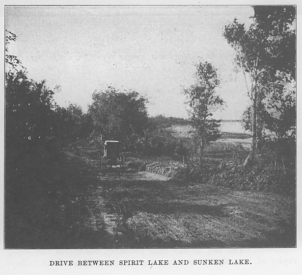
"Minne Waukon or Spirit Lake, the largest body of water in Iowa, occupies the greater part of the township of the same name. Its extreme length from north to south is a little more
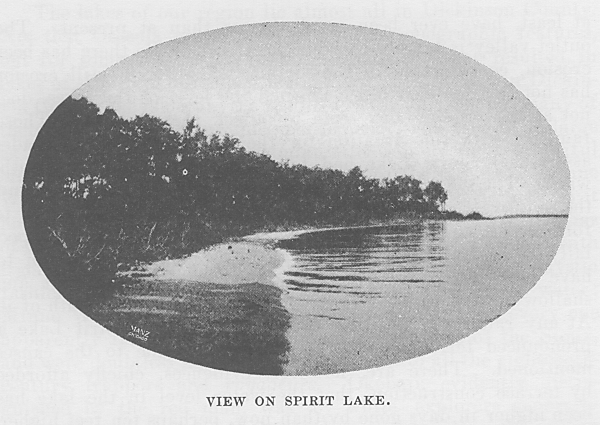
than four miles, in Iowa. The extreme width is about the same, but owing to irregularity of contour the area is not more than ten square miles, while the circumference is nearly sixteen. The depth of the lake is said to be thirty feet; the bottom, so far as can be learned, is almost even, so that from the deepest part to the shores the diminution in depth is remarkably gradual. The shores are for the most part comparatively low, the waterline sandy, affording unlimited beach. Hard by on the west lie Marble Lake, Hottes Lake, and Little Spirit Lake, separated by only the shortest distance from the main body of water, but draining one into the other and north—at length, however, tributary to Spirit Lake. Those interested have in recent years cut a channel to bring Little Spirit Lake and its congeners into more direct communication with the larger water, apparently with small success. In dry years no lake has anything to spare. Strangest of all, in the middle of the series, in the south half of section 17, lies Sunken Lake, distant from Spirit Lake only a few rods, and parted from it by a wall of drift some twenty or thirty feet high and at its summit scarcely a rod in width. So abrupt are the shores and so peculiar the situation that common rumor asserts the lake a matter of recent formation; some people even declare that so lately as twenty years ago trees stood where now the water is ten feet deep. The name Sunken Lake records the popular estimate and explanation of the remarkable phenomenon. It seems probable, however, that Sunken Lake is as old as any of the others, and while a most remarkable bit of topography, sufficiently wonderful to demand, even peremptorily demand, an explanation, yet is it quite in harmony with its entire surroundings, and not, without parallel in many only less conspicuous cases. For instance, on the east side of East Okoboji Lake, in the southwest quarter of Section 15, Center Grove township, there are two small lakes even nearer the principal lake than in the case we have just considered and similarly walled off from the greater body of water by a pile of drift. Similar situations on a small scale may be pointed out in every part of Dickinson County. The only explanation is the unevenness of the lower surface of the ice-sheet which rested here,, advanced no further, and as it melted retreating even farther and farther northward, left behind, perchance as blocks of ice, these pools of clear, fresh water. Sunken Lake may then
represent an ice bowlder ; this seems more probable since its walls are steep, unbroken on every side.
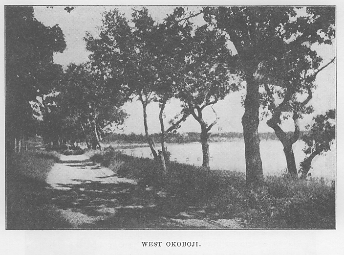
"South of Spirit Lake lies Okoboji, in its two sections stretching somewhat in the form of the letter U, open to the north, partly in Center Grove, partly in Lakeville township. West Okoboji, which represents the western side of the U, lies almost wholly in Lakeville. This is by many estimated the most beautiful water in the series. Its greater depth, more picturesque winding shores give it some advantage over Minne Waukon, although the latter shows the greater expanse of water. West Okoboji Lake, or simply Okoboji, as it is commonly called, extends nearly six miles in greatest length and almost three at the point of greatest breadth. The greater portion of the lake is, however, narrower, so that the total area does not exceed seven square miles, while its irregular contour measures nearly eighteen miles, as platted. The depth of the lake varies very much at different places and is variously reported. The bed of the lake probably resembles the topography of the adjacent country; it has its hills and its valleys. There seems no reason to doubt that there are many places where the depth is at least one hundred feet, but soundings of two or three times that depth are reported.* (*These particulars are from the reports of fishermen and boatmen about the lake.)
"The shores of Okoboji are for the most part high walls of bowlder-clay and drift; sandy beaches are less frequent. Everywhere the erosion of the waves has shaped the shores, undermining them and sorting their materials ; the fine clays have been carried `out to sea,' while the weighty bowlders are left behind every winter to be pushed up closer and closer by the ice, at length piled over one another in ramparts and walls, often riprapping the shore for long distances as if to simulate the work of civilized man. A beautiful illustration of this is seen along the southern shore of Lake East Okoboji, section 20. The less attentive observer would surely conclude that those stones were piled up by `art and man's device,' a seawall to prevent further encroachments of the tide. At the southern end of Okoboji, near Gilley's Beach, is another fine
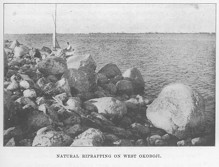
display of bowlders, notable not so much perhaps for their position as for their variety and beauty. Here arc bowlders of limestone, bowlders of granite of every sort, porphyry, syenite, trap, greenstone, quartzite, what you will, the debris of all northern ledges. Similar deposits are visible all around the lake, more especially on the eastern side, probably because the prevailing winds being westerly, the waves have exerted their more constant energy along the eastern bluffs."
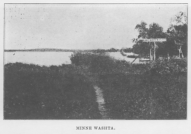
His descriptions of East Okoboji, Minnie Washta, Center Lake and Gar Lakes are equally fine, but must be excluded for lack of space. In conclusion he says: "These lakes taken altogether form one of the attractions of Iowa. Their preservation in their pristine beauty is a matter of more than local interest."
Originally what now comprises the state of Iowa was occupied by several different tribes of Indians. These several tribes were descended from one or the other of two parent races, viz.: the Algonquins and the Dacotahs. The Algonquins were the most numerous and powerful of the native races. They originally occupied the valley of the St. Lawrence River from whence their migrations were gradually westward to the Great Lakes, and eventually to the Mississippi and even beyond. They were divided into a large number of tribes having their saparate interests, but speaking a common language and owning a common ancestry.
The Algonquin tribe which figured the most prominently in the history of Iowa were the Sacs and Foxes. These were originally two different tribes, but Indian history informs us that they were united about the year 1712 and moved towards the Mississippi River. The names Sacs and Foxes were given them by the whites. The Indian name of the Sacs was the "Outagamies" and that of the Foxes was the "Musquawkies." Very little is known of then for the first hundred years after they moved to the Mississippi. When Lieutenant Pike, in 1805, made his first voyage of discovery up the river he saw a great deal of them and learned considerable about them. He estimated their number at that time to be not far from five thousand. Judge Fulton says that "According to a communication submitted to Congress by President Monroe, in relation to the Indians, in 1825, the Sacs and Foxes were estimated at six thousand four hundred, more than one-half of whom resided west of the Mississippi." They were the hereditary enemies of the Sioux, who were a native tribe which the Sacs and Foxes strove in vain to dispossess. They had previously conquered and driven out the Iowas and taken possession of their country. They had also been successful in their wars with other tribes, but they met more than their match in the fierce and terrible Sioux, and were in a fair way to be finally overcome by them when the United States authorities interfered and endeavored to put a stop to the hostilities, in which they were but partially successful. The most prominent chief of this tribe known to the whites was the renowned "Black Hawk." Other chiefs of prominence were Pashepaho, Keokuk, Appanoose, Poweshiek, Wapello, Kishkekosh and many others. Judge Fulton gives a list of one hundred and fifty-seven names of members of this tribe copied from the daybook of one of the old traders. In 1845 and 1846 they were removed to a reservation in Kansas. A short time later a "lingering remnant" of the tribe, becoming dissatisfied with their Kansas hone, wandered hack to their old haunts on the Iowa River, where they were allowed to gain a foothold and follow the free and easy life of their ancestors in the midst of a progressive and highly civilized community. They have readopted their ancient name and are now known to their white neighbors as "Musquawkies."
Another of the Algonquin tribes, which at one time had a home in Iowa, was the Pottawattamies. When they ceded their lands east of the Mississippi in 1833, they were placed on a reservation near Council Bluffs, where they remained until 1846, when another treaty was concluded with them by which they disposed of their land in Iowa and moved west of the Missouri. As with the Sacs and Foxes so with them after being on their reservation for a short time a few homesick stragglers under the lead of the well known Johnnie Green, wandered back to their old haunts in central Iowa, where they fished, hunted and strolled about, undisturbed by their white neighbors until they passed out by life limitation or were merged with the Musquawkies.
The Illini, or Illinois, as they afterward came to be called, were a powerful confederacy made up of five distinct tribes of Algonquins, and at the close of the Seventeenth Century inhabited central Illinois and southern Iowa. It was members of this tribe that Father Marquette came in contact with on his. memorable voyage down the Mississippi in 1673. Historical accounts relate that he made the entire trip from the Fox River in Wisconsin to the point where he discovered "the footprints in the sand" near the mouth of the Des Moines River in Iowa without encountering a single native. After landing he followed the trail inland to an Indian village, and found to his great delight that the savages there spoke the same language as those he had left on the shore of Green Bay. Later on this powerful confederacy became much reduced by a sanguinary war with the Iroquois, and by the time of the Louisiana Purchase in 1803 were either exterminated or had joined other tribes and so had passed out of existence as a distinct nation.
Another strong tribe of the same race inhabiting the state of Iowa at the time of the French explorations, but which became extinct before the time of the Louisiana Purchase, were the Muscatines, or Mascoutins, as they were then called. But little is known of this tribe, although there is abundant proof of their once having occupied both sides of the Mississippi near where the city of Muscatine now stands. Judge Fulton closes a chapter regarding them, as follows: "Having left the last traces of their existence on what is now Iowa soil we have perpetuated the memory of this vanished people by enrolling the appellation Muscatine in our Indian geographical nomenclature."
It would seem that a careful study of the history of the different tribes about this period would cause many people to revise their preconceived notions of the rights and wrongs of the American Indians. According to the most reliable estimates there were originally not far from half a million natives scattered through the territory of what is now the United States. The theory that this vast empire, capable of supporting its hundreds of millions of population, should have been preserved in its native wildness for the gratification of the savage instincts and propensities of these few thousand warriors is at least debatable if not wholly untenable. The main occupation of these tribes was war among themselves. Upon the least provocation and on the flimsiest pretext they rushed into the most deadly and destructive warfare with each other. They fought for the love of fighting. Entire tribes were exterminated and others greatly diminished. There is every reason to believe that the number of native inhabitants was largely diminished during the last half of the Seventeenth and the first half of the Eighteenth Centuries by reason of this bitter, unrelenting warfare. The number of Indians who have fallen first and last in the various actions with the whites is wholly insignificant when compared with the numbers slain in wars among themselves. Of course there have been many instances of dishonesty and bad faith in dealing with the Indians, but that doesn't change the main proposition that in the nature of things it was never intended that this vast continent should be shut off from civilization in order that a few tribes of bloodthirsty savages should be undisturbed in their favorite diversion of waging relentless warfare against each other.
The Dacotah tribes figuring in Iowa history are the Omahas, the Iowas, the Winnebagos and the Sioux. It is doubtful whether the Omahas ever had a permanent residence on Iowa soil, but they frequently visited the state and were closely connected with the Iowas, who were of the same race and spoke the same language. Judge. Fulton, in writing of the Iowas, uses the following language : "The Iowas were once a strong and powerful tribe and were able under their brave and warlike chiefs to maintain successful warfare against their enemies. Their later seat of empire was in the Des Moines Valley. Their principal village was situated on the Des Moines River near the northwest corner of Van Buren County, where the old trading post of Iowaville was subsequently located. That spot may be regarded as historic ground, for there transpired events in the annals of savage warfare which transferred the sovereignty of the Des Moines Valley from the Iowas to the Sacs and Foxes." The decisive battle in which the Iowas were so signally defeated by the Sacs and Foxes occurred some time between 1820 and 1825. During the latter year the government purchased their undivided interest in the country, whatever it might have been, and they were placed under government protection and settled on a reservation beyond the Missouri River. The only prominent chief of this tribe whose name has been perpetuated in Iowa is Mahaska.
Another Dacotah tribe at one time residing in Iowa were the Winnebagos. This tribe when first known were located west of Lake Michigan near Green Bay. Their history is a checkered one which cannot be repeated here. After the Black Hawk War they were removed from Wisconsin to the "Neutral Ground" in Iowa, where they remained until 1846 when they were again removed to a reservation in Minnesota near Mankato. They remained there until after the Sioux outbreak in 1862 when they were sent to a reservation on the Missouri in South Dakota. Of their chiefs those who have been remembered by the people of Iowa are Winneshiek, Waukon Decorah, and One Eyed Decorah. It was the latter who delivered Black Hawk a prisoner to the United States Indian Agent at Prairie du Chien at the close of the Black Hawk War.
The main branch of the Dacotah race are called Sioux. Many persons consider the terms Sioux and Dacotah as applying to the same people. This is not strictly true, since several of the Dacotah tribes, as the Iowas and Winnebagos, and some others, have never been called Sioux. Still no great confusion of ideas can arise from using the terms as interchangeable. While the term Dacotah is the more comprehensive of the two, the term Sioux is the best known and the one with which the people are most familiar. These Indians originally occupied the western part of Wisconsin, the northern part of Iowa, the greater part of Minnesota, the whole of North and South Dakota, and much of the country west to the Rocky Mountains. The first well authenticated meeting of the whites with the Dacotahs was in 1662, but for nearly fifty years previous to that time fabulous stories had reached the French on the St. Lawrence River of a wonderful people who dwelt far to the westward and who spoke a different language from any with which they were acquainted. These mysterious reports made such an impression on the mind of Champlain, the Governor of New France, that he determined to investigate. Accordingly in 1634 he induced Jean Nicollet to undertake a journey of exploration in the region beyond what had then been discovered. Nicollet's account of his journey reads like a fairy tale, but he did not succeed in reaching the Sioux on that trip. A very interesting paper by Hon. Irving B. Richman, entitled, "First Meeting with Dacotahs," says: "The first meeting of the Dacotah Indians by white men took place at a spot not so remote from the lake regions of Iowa. In 1662 the French travelers, Radison and Grosseliers, held a council with a large company of the Dacotahs near the Mille Lacs, in what is now the state of Minnesota. They were even then a famous and dreaded nation. Says Radison in his quaint and Gallic way: They were so much respected that nobody durst not offend them.' "
Eighteen years later or in 1680, the Mississippi River having been discovered in the meantime, Father Hennepin was sent out by La Salle to explore the upper regions of it. Judge Fulton, in his introduction to a chapter on the Sioux, uses this language: "It was in 1680 that Father Hennepin and his two companions, Michael Ako and Anthony Anguella, were sent from Fort Crevecour, near Lake Peoria, by the renowned La Salle on their mission of discovery to the upper Mississippi. The tribes they found inhabiting the country now embraced in northern Iowa and the state of Minnesota were those belonging to the great Dacotah group or nation. While encamped on the banks of the Mississippi they were taken prisoners by a band of Sioux warriors, and remained with them in their wanderings over the vast prairies and among the lakes of that region from April until September, having during that time been joined by that other intrepid French adventurer, Duluth. These were the first Europeans who met the people that occupied and roamed over the prairies of northern Iowa, or kindled their campfires about the headwaters of the Des Moines and on the borders of our beautiful lakes two hundred years ago."
The numerical strength of the Dacotahs was then estimated at about forty thousand and does not vary a great deal from that at the present time. The nation was divided into a large number of tribes and these tribes were again subdivided into numberless clans or bands, each under its petty chief or leader, who roamed over the prairies far and wide, living on game and fish and the spontaneous production of the soil. They lived mainly in rude tents called "tepees" and roamed about as inclination dictated. They had favorite haunts which they visited at, stated periods and which were regarded by them as headquarters, where different bands would rendezvous for a while and then scatter again over the prairies and their places be occupied by other bands. Judge Fulton, in his "Red Men of Iowa," says: "At the time of the celebrated voyage of exploration made by Lewis and Clarke in 1804 up the Missouri River, the band or tribe of the Great Sioux nation, known as Yanktons, lived on the upper Des Moines and Little Sioux Rivers and the region about Spirit Lake." But little reliable information can be obtained calculated to throw light upon the history of the different bands that occupied this country previous to its purchase and settlement by the whites. Authorities seem to agree, however, that a band of Yankton-Sioux, known as the Wahpekutahs, occupied the country of northern Iowa and southern Minnesota during the earlier part of the present century. North of these in Minnesota were three other tribes of Sioux for whom agencies were subsequently established on the Minnesota River, which will be noticed more in detail further on.
The Sioux were the deadly enemies of the Sacs and Foxes, the Wahpekutahs being the most active in their hostilities and the most implacable in their hatred of their southern neighbors. So sanguinary was the warfare waged by the contending tribes that the United States government, in 1825, decided to interfere and if possible put a stop to it. By a treaty, bearing date August 19, 1825, a boundary was established between the Sioux on the north and the Sacs and Foxes on the south, as follows : Commencing at the month of the upper Iowa River on the west bank of the Mississippi and ascending the said Iowa River to its west fork, thence up the fork to its source, thence crossing the fork of the Red Cedar River in a direct line to the Calumet or Big Sioux River, and down to its junction with the Missouri River.
This action of the government only made matters worse, each party claiming that the other had trespassed by crossing over the line, and hostilities waged hotter than ever until in 1830, when the government interfered a second time and finally succeeded in negotiating a second treaty, whereby the several tribes ceded to the United States a strip of land twenty miles wide on each side of the former line, thus throwing the combatants forty miles apart. This strip was known as the "Neutral Ground." Many persons at the present time use the term without knowing its meaning. This scheme mended matters some but did not wholly prevent hostilities, which were kept up to a greater or less extent until 1845, when the Sacs and Foxes were removed from the state.
The last hostile meeting between the Sioux and the Sacs and Foxes was in Kossuth County, in April, 1852, between two straggling bands, both of whom at that time were trespassers and had no legal right on Iowa soil. This action possesses a dramatic interest out of all proportion to its importance as a historical event, from the fact that it was here that the "lingering remnants of two great nations who had for more than two hundred years waged unrelenting warfare against each other had their last and final struggle." The number engaged was about seventy on a side, and the result was a complete victory for the Sacs and Foxes.
At the same time of the treaty respecting the Neutral Ground, July 15, 1830, another treaty was negotiated by which the Sacs and Foxes, Western Sioux, Omahas, Iowas and Missouris united in conveying to the United States the portion of the western slope of Iowa described as follows: Beginning at the upper fork of the Des Moines River and passing the sources of the Little Sioux and Floyd Rivers to the fork of the first creek that falls into the Big Sioux or Calumet River on the east side, thence down said creek and the Calumet to the Missouri River, thence down said Missouri River to the Missouri state line above the Kansas River, thence along said line to the highlands between the waters falling into the Missouri and the Des Moines, passing to said highlands along the dividing ridge between the forks of the Grand River, thence along said highlands or ridge separating the waters of the Missouri from the Des Moines to a point opposite the source of the Boyer River, thence in a direct line to the upper fork of the Des Moines, the place of beginning.
By the terms of this treaty the United States agreed to pay to the Sacs and Foxes three thousand dollars each; to the Sioux, two thousand dollars; to the Yankton and Santee bands of Sioux, three thousand dollars; to the Omahas, two thousand five hundred dollars; and to the Otoe and Missouris, two thousand five hundred dollars, to be paid annually for ten successive years. In addition to these annuities the United States agreed to provide other advantages for some of the tribes joining in the treaty. This treaty was made by William Clark, Superintendent of Indian Affairs; and Col. Willoughby Morgan, of the United States First Infantry. It went into effect by proclamation February 24, 1831. So much for the treaty by which the territory of western Iowa passed from the jurisdiction of the Indians to the government of the United States.