 |
Chickasaw County IAGenWeb Project |
[The following Historical Introduction by William J. Petersen appears in the 1970 State Historical Society of Iowa reprint of the 1875 A. T. Andreas’ Illustrated Historical Atlas of the State of Iowa]
Historical Introduction
ALFRED T. ANDREAS
Alfred T. Andreas, the compiler of this prodigious Atlas, was born on May 29, 1839, in Amity, Orange County, New York. His family moved to nearby Chester where young Alfred gained a good education at Chester Academy. While Alfred was still in the Academy, his father moved to New York City where he became a successful merchant, retiring a wealthy man in 1858. Meanwhile, Alfred struck out for the Mississippi in 1857, locating at Dubuque. He held clerical and teaching positions in Dubuque until 1860, when he moved to Sparta, Illinois, where he continued his work as a teacher.
In 1861 young Andreas enlisted as a private in Company G of the 12th Illinois Infantry, giving his residence as Pinckneyville, Illinois. His pleasing personality and genius for organizing led to rapid promotions. In 1864 he became Division Commissary on the staff of General Thomas W. Sweeny, and later Quartermaster with General John M. Corse, in the Atlanta Campaign. He served in this capacity with Sherman on his March to the Sea, and subsequently in that brilliant commander's campaigns through the Carolinas.
When Andreas was mustered out of the army on April 1, 1865, his residence was given as Davenport, Iowa, in the Report of the Adjutant General of the State of Illinois. It appears that Alfred T. Andreas had visited Davenport while on a furlough during the Civil War. He liked the town and he also liked a young lady whom he met there. Accordingly, after his discharge from the army, he returned to Davenport and married the girl—Sophia Lyter, daughter of Samuel Lyter and sister of John M. Lyter.
It took several months for young Andreas to find himself after the war. Having risen to the rank of a captain in the Quartermaster Corps during the Civil War, he bore this title with honor and distinction throughout his life. An imaginative and resourceful young man, the newly married Andreas determined to leave no stone unturned in his effort to win a competency.
Like many an entrepreneur, Andreas sometimes embarked on risky ventures. During the winter of 1865-1866, he conceived the idea of establishing a skating rink at the top of Brady Street hill in Davenport. The idea turned out to be an ill-advised undertaking. On December 19, 1865, the Davenport Daily Gazette recorded:
We regret the gloomy prospects of an early success of Capt. Andreas' Park in North Davenport. Much money has been expended in preparing it for use, and in making it a most delightful place of resort for those who want to skate in good style.—On account of the failure of his wells to supply the quantity of water necessary, Capt. Andreas undertook, on Friday, the seeming impracticable task of flooding the Park by hauling water from the river, —nearly a mile, in wagons and water-carts.—A great quantity of the water is immediately absorbed by the new made ground, and after three days hauling but very little impression had been made. The Captain has shown a Spartan energy in prosecuting his project, and seems undaunted yet. We most sincerely wish his energy may be rewarded with success; fearing, however, it will not be so this season, in time to return him much profit.
The foreboding of the Gazette appeared well-founded. On December 22, the same Davenport editor declared:
CAPT. ANDREAS has, for the present, abandoned the attempt to flood his Park on the bluff. He will resume operations as soon as success seems practicable.
Since skating rinks were not his specialty, Andreas turned his attention to a field that was destined to win him lasting fame, namely state and county atlases. Of this field Walter W. Ristow, associate chief of the geography and map division of the Library of Congress, has written:
THE PRODUCTION of state atlases is one of the underdeveloped branches of American cartography. Robert Mills's Atlas of the State of South Carolina, the first of an individual state, was published in 1825, nearly five decades after the Republic was established. Four years later the Atlas of the State of New York by David H. Burr was published. These two distinguished and handsome volumes were the only state atlases printed from engraved plates. A revised edition of Mills's work was published in 1838, and several revisions or re-printings of Burr's Atlas were issued between 1829 and 1841. No other state atlases were published until after the Civil War, but in the two decades after 1865 they were produced in great numbers. More than thirty volumes, covering some twenty-two states, were published between 1866 and 1887. New England, the Middle Atlantic region, and the Middle West were the principal centers of atlas activity.
In 1867 three former army associates—the Thompson brothers of Geneva and Louis H. Everts—persuaded Andreas to join their staff of canvassers in producing large maps of Illinois counties. It was not long before Andreas became one of Thompson's most successful salesmen. His personality, his industry, his general bearing and manner of speaking, stood Andreas in good stead in his work.
Andreas soon conceived the possibility of new sources for profit. He believed that if a huge county map was cut into townships and these bound into book format, an entirely new market would be opened to him. Such a publication could be sold in counties for which large maps had previously been published. This book could have an unlimited number of pages devoted to township maps; historical sketches of farms and business firms; biographical sketches of farmers and leading businessmen.
At specified rates per line of text or square inch of portrait space, the income from subscriptions, which usually averaged around $9 per atlas, would be greatly increased. It has been estimated that for an edition of 2,000 to 2,500 copies, the publisher might gross $35,000, almost one-half of which could be net profit.
The prospects of gaining untold wealth led Andreas to resign his position with Thompson and Everts and form a partnership with his father-in-law as Andreas, Lyter & Company. Under this and other imprints he published Fulton County and Knox County atlases in 1871, Adams, Morgan, Pike, and Schuyler counties in 1872, and Scott and Tazewell counties in 1873. These were all Illinois county atlases printed in Davenport and in the possession of the Library of Congress.
During 1873 Andreas moved to Chicago where he established himself in the Lakeside Building at the corner of Clark and Adams. This building had been created especially for the publishing business, according to Harrington's How 'Tis Done, and was particularly set up for the printing of atlases. Three Iowa county atlases—Des Moines in 1873, and Lee and Louisa in 1874, were produced by Andreas in Chicago.
It was in the Lakeside Building that Andreas published his first state atlas, that of Minnesota, in 1874, and it was in this building, too, that Alfred T. Andreas published his Illustrated Historical Atlas of the State of Iowa—1875.
It took an army of skilled personnel to solicit subscribers, compile the history, execute portraits, draw pictures of homes, farms, buildings, and cities, and record faithfully and reliably the maps and plats of counties and towns. The magnitude of this stupendous enterprise (it required the services of 300 men for an average of a year and a quarter) is attested by every page of A. T. Andreas' Illustrated Historical Atlas of Iowa. The success of the original solicitors, as well as the favorable impressions left by artists, historians, and cartographers can be further demonstrated by the fact that nearly 23,000 subscribers—the majority of whom were leaders in their communities and influential men of Iowa—became patrons, or subscribers, to the gigantic project.
Iowa editors appeared almost uniformly enthusiastic at the prospects of securing a detailed State atlas. The Davenport Gazette of August 22, 1874, expressed delight when it learned its former fellow-townsman would head up this monumental work:
Capt. A. T. Andreas, formerly of this city, and more particularly remembered by many of our citizens in connection with his skating park enterprise on the bluff in the winter of 1865-6, has put his indefatigable energy and industry to more practical purposes. He is now the head of an extensive map and atlas manufactory, with hundreds of skilful artisans in his employ, and a business amounting to this year of over a million dollars, according to the Chicago Times. He has now 108 men employed in Minnesota alone. surveying, drafting and soliciting, making maps of every county in the State, with handsome engravings of men and houses, and writers engaged to give biographies, histories of localities, etc. The Times, to give an idea of the magnitude of this work, says the paper employed weighs over seventy tons, while the cardboard for the cover alone exceeds seventeen tons, and when completed it will require the service of twelve ordinary freight cars to transport to Minnesota. This is drawing heavy on the imagination or on railroad transportation! Capt. A. is also engaged in mapping many counties in other States, each county making a large book of maps, engravings and reading. He has a contract, the same paper says, for publishing a map, etc., of Iowa, and in a few days will put a hundred and fifty men in the field to work up the details. The maps will be lined engravings, instead of the usual lithographs. So much for our Davenporter abroad.
Two months later, on October 15, 1874, the Anamosa Eureka carried the following advance publicity, issued by A. T. Andreas himself, on the proposed Illustrated Historical Atlas of the State of Iowa:
TO THE PUBLIC—I propose publishing an Atlas of the State of Iowa, containing a map of every County in the State, showing Sections, Timber, Prairie, Roads, Railroads, Streams, School Houses, Churches, etc., etc. Fine maps, 14x28 inches, of the State of Iowa, United States and Territories, and of both Hemispheres. Plans, with histories of the Cities, Towns, Villages, and Counties of the State. Biographies of a large number of early settlers and prominent men in the State. Also a condensed political history of the State, giving votes, etc. Six maps of Iowa, so colored as to show the Geological and Climatological condition of the State, with also the Congressional, Senatorial and Representative Districts. Sixteen maps of the United States, colored in five fine shades, to show the amount of Wheat, Corn, Hay, Cotton and Tobacco raised in proportion to acres cultivated. Also to show deaths by consumption and other diseases, in proportion to the deaths by all diseases, and to show density of population, and proportion of colored, and various foreign nationalities in the United States.
An immense amount of very useful statistical information, covering about 50 square feet of closely printed matter in every Atlas. To the patron of the work is published his name, residence, business, nativity, post-office address, and when he came to the State, besides locating name and residence on his land. The whole will be illustrated by fine lithographic views of hundreds of public buildings and private residences in both town and county, and portraits of prominent men.
A large force of experienced men will commence immediately an experimental canvass; and if sufficient encouragement is received, I hope to complete the work sometime during 1875. Yours truly,
A. T. ANDREAS, Publisher
Chicago, Ill.
Apparently the advance agent, or solicitor, in Jones County did very well, for on October 29, 1874, the Anamosa Eureka declared:
IOWA ATLAS—Mr. Boston, the atlas man, dropped in yesterday and showed us how he was succeeding in the canvass of this town. He has al-ready secured orders of a large number of our leading business men, and the canvass is not nearly completed. We are glad to learn that the work is meeting with so good success. and that the people of Iowa appreciate and encourage such an undertaking.
Since the success of the atlas depended on the number of subscribers, it was important to enlist the wholehearted support of the most influential citizens in each community. The following endorsement from the "First Citizen" of Iowa—Governor C. C. Carpenter—was printed in the Belle Plaine Union of November 19, 1874:
To Whom it may Concern:—I have examined the proof sheets of the Minnesota Illustrated Historical Atlas, by Capt. A. T. Andreas, of Chicago. and I regard it as a work of superior merit, and it seems to me any citizen of Minnesota could hardly do without it. I understand from E. T. Phelps that Capt. Andreas is now taking the preliminary steps preparatory to publishing a similar Atlas of Iowa, with such improvements as past experience in this business naturally suggests to his mind.
Having known Mr. Andreas intimately and well for many years, I have no hesitation in assuring all who may read this that he will do all he proposes, and that the public will find his work fully equal to the promises of his circular and advertisements.
C. C. CARPENTER
The above appeared in scores of Iowa newspapers.
At least one sour note, which smacked of partisan politics rather than a diatribe against the Andreas Atlas, was contained in the Burlington Daily Hawk-Eye of December 16, 1874:
We question if it isn't in rather bad taste for the Governor of the Commonwealth of Iowa [C. C. Carpenter] to go into the puffing business and sign his name, under the official date of the "State of Iowa, Executive Department," to the statement that "It seems to him that any citizen of Minnesota can hardly do without" a certain map of the State, recently published. This map is an excellent one. we believe, but it is, or should be considered, a little below the dignity of the Governor of a great and growing State to go into the puff business, especially at such an exaggerated rate as the sample given above indicates. There are plenty of very good and very intelligent citizens who get along very conveniently and happily without State maps, and Governor Carpenter knows it. But, whether he is inditing a message, a thanksgiving proclamation. or a puff for a map, it is our Governor's failing to use so many words that he almost invariably says more than he means.
To canvass the entire State with its more than a million inhabitants was no small feat in 1875. It would be natural to expect that the canvassing part of the work that was destined to be distributed in fourteen months, would certainly be completed long before July 1st. It was not until the spring of 1875, however, that the atlas salesmen got as far west as Adams County. On April 15, 1875, the Adams County Union (Corning) declared:
Mr. Stacey, representing Andreas' Historical Atlas of Iowa, has arrived in Corning, and will wait upon the citizens of this County for their subscriptions to this invaluable work. We hope Mr. Stacey will meet with the greatest success. The book he represents will be the greatest, grandest, best thing ever gotten out for our State. We have already stated a few of its merits in these columns, and Mr. Stacey has now with him a copy of the Historical Atlas of Minnesota, which will show the plan on which the Iowa Atlas is projected. It should be borne in mind, however, that the Iowa Atlas is expected to surpass the Minnesota Atlas in many important respects.
Mr. Andreas has an army of agents in the field in the state, and confidently expects to meet with sufficient encouragement to warrant him in sparing no pains or expense in making the Atlas valuable, not only as a historical, statistical, and geographical work, but as a work of art. Every citizen—especially every old settler—will be particularly interested in possessing a copy. The price is some-what higher than an ordinary book, but it should be remembered this is not an ordinary book. And when its many merits are considered the price is none too high. The subscription is not to be paid until the Atlas is delivered.
See Mr. Stacey and give him your name. Don't let Adams County be behind the other counties of the State in this matter.
Mindful of the loss he had sustained in producing his Minnesota Atlas, Andreas pushed his Iowa sales force until well into the summer. Thus, on June 30, 1875, the Marengo Republican noted:
Mr. J. H. Hackett is now engaged in canvassing Iowa County for subscriptions to this valuable work, which is expected to be completed and ready for delivery some time during the coming fall... . We advise all of our readers to give the work a careful examination when presented for their inspection, and also to subscribe for a copy if they desire to secure a perfect and reliable map of the State of Iowa.
The fact that solicitation was still going on for subscribers less than five months before delivery of the huge volume began in Iowa must amaze the average printer in 1970 who is faced with the problem of solicitation, compiling, typesetting, proofing, printing, folding, collating, and binding a volume. It also helps explain why there were gaps and errors in pagination as the Chicago printers completed various signatures that had been assigned a certain number of pages for Congressional Districts only to have them usually fall short, but sometimes run over.
As one phase (and a very important one) of Andreas' Illustrated Historical Atlas of the State of Iowa we must not overlook the artists who were enlisted to perform their work in the field, and at the home office in Chicago. Since 1875 was a year when the stagecoach and the livery stable still afforded an important means of access to many smaller Iowa communities, the artists who were assigned to the field doubtless outnumbered the steel engravers in Chicago who copied the original art work on steel plates. The Clayton County Journal (Elkader) of November 25, 1874, noted:
ANDREAS' ATLAS.—Mr. W. W. Elliott, artist of the grand State Atlas enterprise, is in town soliciting views for presentation in this work. We should be glad to see Elkader and vicinity go "into pictures" to a reasonable extent. Parties desiring to confer with Mr. Elliott will find his headquarters at the Boardman House.
Three weeks later, on December 16, 1874, the same editor noted:
Our "special artist on the spot," for Captain Andreas' great atlas is sketching the best looking things in and about Elkader. Of course our picture' is in.
Aside from being a plug for Andreas' Atlas the previous two quotes would indicate that a considerable length of time was spent by an artist in a relatively small community. Only one portrait of a Clayton County citizen appears in the book—that of Alexander McGregor. Four Clayton County town plats—Elkader, Guttenberg, McGregor, Strawberry Point—were included in the Atlas. In addition, eighteen Clayton County pictures graced the Congressional District section of the Atlas while nineteen were counted from adjoining Fayette County. And, if the "picture'" of the editor of the Clayton County Journal (Elkader) did not appear among the portraits, at least the picture of the newspaper office itself, with J. W. Shannon's name as editor, was recorded for posterity in a neat drawing.
The publication of A. T. Andreas' Illustrated Historical Atlas of the State of Iowa—1875 was the most monumental Iowa history up to that time. As a reference tool it far eclipses any and all other volumes. As a matter of fact, nothing that has been printed since 1875 would begin to include, as does Andreas, the varied aspects of the Iowa scene from the beginnings of white settlement down to 1875.
The ten pages, containing 220 steel engravings of Iowans, represent a portrait gallery of historic and contemporary citizens that cannot be duplicated elsewhere. The neatly executed county maps—83 full page county maps and three double page spreads to delineate the 16 relatively unsettled counties in Northwestern Iowa—make an unusual and unique contribution to Iowa history and cartography. The 44 pages devoted to 198 plats of Iowa cities and towns, some of the latter very small, provide another rich resource to Iowa land as it appeared almost a century ago. The 182 pages containing 587 handsome engravings of homes, farms, churches, schools, colleges, breweries, livery stables, industries, hotels, courthouses and public buildings, represent a pictorial art gallery that can-not be duplicated by any combination of publications up to that time, or indeed by anything else that has appeared in the century that has elapsed since the appearance of the Andreas Atlas in 1875. Over the years the Andreas volume has been consulted more frequently than any other book in the rich collection of almost 100,000 volumes in the State Historical Society of Iowa Library.
Thus far we have seen that approximately 361 of the 596 pages of this colossal undertaking are pictorial in character. The remaining 233 pages may be divided as follows:
Biographical Sketches 31
Iowa, Topography, Geology, Climate 4
State History 26
County Histories 84
Patrons of the Atlas 56
Business Directory of Patrons 18
The widespread coverage of Iowans who chose to have their portraits appear in Andreas' Historical Atlas is demonstrated by the 65 towns sprinkled throughout the nine Congressional Districts. It is also worth noting under "Most Pictures" that Davenport—the city where Andreas was best known and highly respected—led all other Iowa towns with 33 portraits.
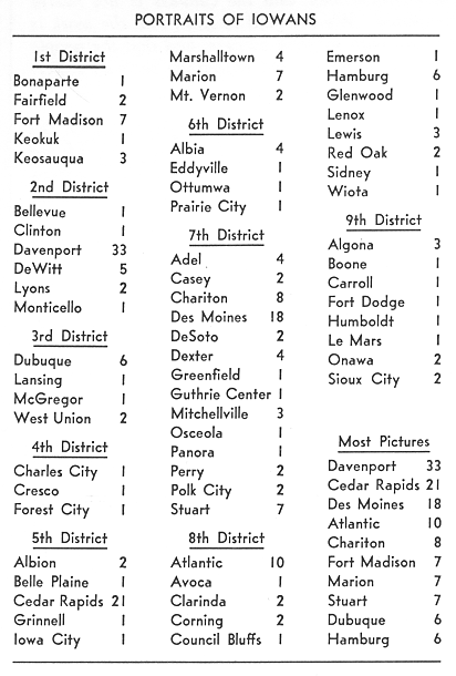
The nine Congressional Districts into which Iowa was divided in 1875 are a far cry from the seven (soon to become six) Congressional Districts in 1970. With the exception of the First District. the participation of the other eight Congressional Districts in the Andreas Atlas was uniformly good in 1875. It should be pointed out that the pages and pictures attributed to each of the Congressional Districts listed below appeared exclusively in the Atlas printed for that particular District.
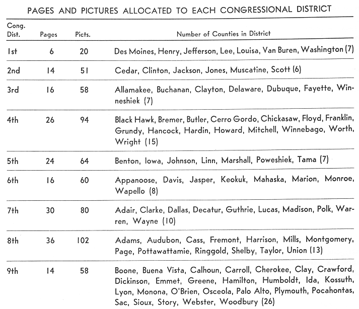
In discussing the pictorial section of the Illustrated Historical Atlas a bit further, one should point out an unusual feature of the present reprint that was not contained in the original Andreas. Apparently believing it would be more practical from the standpoint of both sales and costs, Andreas allocated a certain number of pages for pictorial views of each of the Districts, including only one Congressional District in each bound volume. Thus, by substituting the equivalent of say 16 to 32 pages, or one to two 16-page printer's signatures, the Congressional District picture section would be different in each volume for which it was designed.
But this was where Andreas ran into trouble with his pagination. He probably allocated 16 pages to serve as a pictorial supplement for each of the nine Districts and this worked out almost perfectly for the 2nd, 3rd, 6th and 9th Districts. Unfortunately the 1st District paid enough for a picture section of only 6 pages. Andreas accordingly had to drop the unused 10 pages from his Atlas containing the First Congressional District pictures. This adding or dropping of page numbers continued through the nine Districts. Thus, he was able to bring out his huge volume with each Congressional District having its own pictorial section added to the already large number of pictures permanently included on 39 pages of each Atlas.
We have pulled all these pages together for the nine Congressional Districts and run them consecutively so that they make up a total of 182 pages. These are followed by the regular 39 pages of pictures that pretty well cover the entire State. Iowans who happen to have an original copy of Andreas' Illustrated Historical Atlas can quickly determine which Congressional District is represented in their book by checking the specially inserted pictorial section falling usually between pages 32 and 72. In order to include all nine Congressional District pictures in this volume we have eliminated all United States Census records—population, post offices, etc. which formed part of the original 1875 Atlas. The material contained in this reprint has been restricted solely to Iowa.
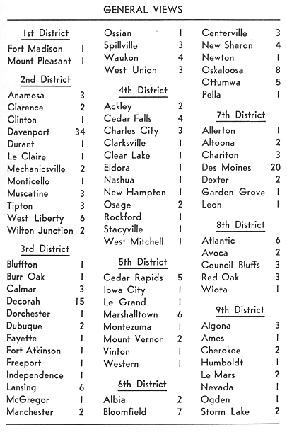
The 39 pages of pictures listed below appeared in all nine Congressional Districts. They were made up of a considerable number of relatively small pictures, although both full and half-page views were included. The fact that 79 towns are represented in this pictorial section attests to the widespread coverage of Iowa by the tireless Andreas salesmen. Again it should be noted that Davenport accounted for 34 pictures in this section, a fact that doubtless entitled the "Queen City of Iowa" to be honored with the frontispiece in all nine Congressional Districts of Andreas' Illustrated Historical Atlas of the State of Iowa—1875.
The reception of Andreas' Illustrated Atlas of the State of Iowa was uniformly enthusiastic. The Cedar Rapids Times of November 11, 1875, was lavish in its praise:
ANDREAS' Atlas of Iowa has been delivered to subscribers here, and we find it to be all the publishers promised—a complete and reliable representation of Iowa, its history, progress and present status. True, it is not free from errors, but we have, as yet, discovered no serious ones, such as will interfere with the value of the work. The pictures of persons and places are, in the main, correct and truthful, gotten up in excellent taste and style. The historical portion of the work is valuable, and taken as a whole, the citizens of Iowa can join the publishers in feeling a just pride in, and commending Andreas' Atlas of Iowa as the finest thing of the kind yet presented to the Iowa public.
The editor of the Daily Iowa State Register was equally warm in his praise. On December 14, 1875, when distribution of the Atlas began in Des Moines, he declared:
Andreas Atlas—Col. F. G. Batty yesterday commenced the work of delivering this work to subscribers in Des Moines. It is printed with great care and neatness, and is a volume that would be ornamental on any table and useful in any library. The Atlas contains 590 pages, 14x20 inches in size, properly indexed. Among the portraits are many of the distinguished men of Iowa; many that have been extinguished. The farm and city views are very handsome.
Two weeks later on December 28, 1875, the Des Moines editor reprinted the history of Des Moines in his columns, headlining the story as—"A Lively Sketch of Early Times—The First Churn The First Church—and The First Baby." Similar accounts appeared in other Iowa papers.
The wide disparity in pictures sold between the First and Fourth Congressional Districts, for example, explains how uniform pagination was impossible in putting together the various sections of the Illustrated Atlas of the State of Iowa.
It is interesting to speculate as to just what happened in the First Congressional District that it merited only six pages containing 20 pictures compared, for example, with 26 pages and 94 pictures in the Fourth Congressional District. What is all the more perplexing is the fact that Des Moines County (Burlington), Henry (Mt. Pleasant), Louisa (Wapello), and Jefferson (Fairfield) are not represented in the above 20 pictures while Washington County is represented by 12 of the 20 pictures. For Lee County, Keokuk has 1 picture, Fort Madison 2 pictures, but tiny Farmington has 4 pictures! The only other picture is one of Keosauqua in Van Buren County.
And, while all of the nine Congressional Districts contained the same permanent 39 pages upon which 239 pictures were shown, again we must note that only 2 of these 239 pictures were associated with the seven counties making up the First Congressional District. Clearly some unfortunate incident must have occurred, possibly in its relationship to the press, for the Andreas Atlas to have fared so poorly in a project that had gained state-wide acceptance. For Keokuk, Fort Madison, and Burlington are three of Iowa's most historic towns, and if anything, they should have led the rest of the state in the number of portraits and pictures used.
That the First District was quite aware of the prospective atlas is attested by the Fort Madison Plain Dealer of December 10, 1874, chronicling the arrival of E. F. Phelps, "Advertising Agent" for A. T. Andreas' Illustrated Historical Atlas of the State of Iowa. Phelps had a copy of the "elegant" Atlas of Minnesota with him for inspection and the Fort Madison editor declared a similar one for Iowa would be "a valuable addition to the Library.” The Plain Dealer carried a typical Andreas advertisement "To the Public" on the same page.
Twelve months later the Keokuk Daily Gate City of December 12, 1875, carried the following from its correspondent in Fort Madison:
There has been an agent here this week delivering the Illustrated Historical Atlas of Iowa to subscribers. This gentleman succeeded much better in delivering than he did in collecting pay for them. The precise amount that he took from here would be hard to tell, but we think about 1 out of every 3 were dissatisfied with the work, and refused to pay on it. A majority of those gentlemen who's faces adorn its pages from this city were so well pleased (?) with their pictures that while contemplating their extreme beauty (?) and correctness they let the agent leave town without paying for them. They are now wicked enough to charge that they were slandered, and if we were that agent or the author of that Atlas, we would take out a policy in some reliable Life Insurance Company before we could be induced to put in another appearance in Fort Madison within the life time of any of the gentle-men above mentioned. We are greatly mistaken if the lawyers don't get something to do before these maps are settled for.
Apparently no legal suits followed and doubtless the remaining third of the atlases were snatched up despite the fact that money was tight following the Panic of 1873. Reference to the Fort Madison portraits will quickly reveal that they were among the very smallest executed, and hence commanded the smallest price to include them it the Illustrated Atlas. When other pictures appeared that were larger the subscribers were deeply disappointed.
Although Andreas was a heavy loser in the Minnesota and Indiana atlases, he appears to have had an uncanny ability in recouping his fortune. Invariably, however, whenever he seemed to be on the verge of amassing a fortune some new venture lured him to financial disaster. Thus, he invested in hotels and dining places to take advantage of the Chicago World's Columbian Exposition, only to lose so heavily as to be forced into bankruptcy.
The only really consistent success Andreas had was in his city, county, and state atlases and histories, and even in these he frequently lost money. But whether he won or lost, posterity must be grateful to this man who through his imagination, enterprise, and courage, left an imperishable record in Iowa and Midwestern history. It would be difficult to produce his equal.
One should not overlook the universally high esteem in which Andreas was held by many professional historians. Dr. Paul M. Angle, long-time Director of the Chicago Historical Society and an outstanding Lincoln and Illinois history scholar, declared Andreas' 3-volume History of Chicago, was "the great mine of Chicago history" even though it now remains "forgotten by almost everyone except librarians." Librarian Walter W. Ristow concurred with Dr. Angle, declaring Andreas' History of Chicago "is still recognized as the best historical record of Chicago in the nineteenth century."
Andreas' Illustrated Historical Atlas of Iowa and his 3-volume History of Chicago have been described by such words as "monumental" or "prodigious." If these words are true, what can one say of his volumes on Kansas and Nebraska?
Far from being 600-page tomes, as was the Iowa Atlas, his History of Nebraska, published in Chicago in 1882, contained 1,506 pages while his History of Kansas, published in 1883, numbered 1,616 page Both books are extremely difficult to pick up. Wright Howes rating them at $25 to $100 on the Rare Americana market. The large number of biographies and portraits contained in the Kansas volume soon caused it to be called the "Herd Book." One authority declared the "completeness of the work is amazing." The price of the Kansas volume was $12 and the printing is said to have reached 15,000 copies.
What manner of man was this Andreas, that he should have displayed such unusual abilities. According to a contemporary description he was "of good personal appearance, above the medium height, and light complexioned. He was ... of slight frame, nervous and incessantly active; young in years, but of sufficient world experience to give him self-command. He had an open countenance, smiled easily and laughed readily. . . . His eyes were blue, frank in their gaze and sure to impress the beholder favorably. His language was good, his manner of speaking earnest, and his bearing, while in conversation, such as to enlist attention and inspire confidence. He was quick to form opinions, reach conclusions and prompt to act. . . . He had mixed with all classes of men, and had purposely studied human nature. His aim in life was to succeed."
And succeed he did! For, with his Illustrated Historical Atlas of the State of Minnesota Andreas introduced a "new format and pattern, as well as a new distribution policy for state atlases," which led him to become "one of the most prolific and successful atlas producers of the post-Civil War period" in the "new and rapidly growing states" of the Upper Mississippi Valley. His "aggressive operational and promotional techniques" differed greatly "from the practices of the established cartographic firms."
Between 1865 and 1885 he published, independently or with associates, approximately thirty county and state atlases. "At least one source," Walter W. Ristow declares, "gives Andreas credit for originating both the illustrated county atlas and the illustrated state atlas. Unquestionably, both types of cartographic publications reached their maximum development under his direction."
The Chicago, Kansas, and Nebraska volumes came out at the end of Andreas' publishing career. Although he continued to live in Chicago for thirteen years, Andreas appeared to gain only modest financial returns from his city directories. In 1897 he moved to Boston, and in 1899 to New Rochelle , New York, where he died on February 10, 1900.
The following notice of his passing appeared in the New Rochelle Pioneer of February 17, 1900:
Colonel A. T. Andreas died last Saturday morning at his home, No. 74 Elm Street, Residence Park, from the effects of paralysis believed to have been superinduced by bullet wounds which he received in the Civil War. Colonel Andreas was taken ill about three months ago while in Worcester, Massachusetts, on business and on his return to this city became bedfast. He suffered from paralysis of the right arm which spread to other parts of the body. The arm became so inflamed that he was removed to St. Luke's Hospital, New York, and the arm was amputated last week....
Colonel Andreas was born in Orange County, New York, and was in his sixty-second year....
He was a former officer of the Loyal Legion and was a Mason. A widow and two children—Mrs. C. M. Atherton and Miss E. Andreas—survive him. The burial was in the Post family plot in Orange County on Tuesday.
The magnitude of printing the original Andreas' Illustrated Historical Atlas of the State of Iowa can be gleaned from the author's Preface. In the present reprint, although the book has been reduced one-third in size to 9 by 12 inches, it still required a staggering amount of paper to print it. Thus, the paper used in the body of the Atlas totaled 71,520 pounds, or almost 36 tons. Measured in still another way, it required two railroad cars to bring the paper stock to Iowa City. The end sheets required an additional 1,440 pounds of paper. The cover stock weighed 13,250 pounds, or 6½ tons and the cartons in which the Atlas was shipped required another 5,600 pounds. Approximately 700 pounds of glue was needed to complete the sewing and binding of 12,000 volumes.
The paper, printing, binding, boxing, and mailing the Atlas was performed by the Economy Advertising Company of Iowa City and the negatives were made by Tru-Art Engravers of Cedar Rapids. The 10,000 members of the Society will be pleased to know that their annual dues, plus sales of publications, underwrote the entire cost of production, from printing to mailing. Not a single dollar came from State appropriated funds.
WILLIAM J. PETERSEN
Office of the Superintendent
State Historical Society of Iowa
Iowa City, Iowa