

Cerro Gordo County Iowa
Part of the IaGenWeb Project
|
The Globe Gazette
 The neighborhood known as the Highlands in northeast Mason City is the location of one of the highest points in Mason City - on the 14th hole of the Highland Park Golf Course. It was also probably the neighborhood where housing development really took off immediately following World War II, said Mason City historian Art FISCHBECK. "A lot of houses went up there by a lot of different contractors," he said. In addition to the public golf course, the Highlands and surrounding area were the site of several limestone quarries, a slough, a private dump, a dairy, a road house and three neighborhood grocery stores, none of which survives today. Many of the people who lived in the Highlands worked at Jacob E. DECKER meatpacking plant, the cement plants and the sugar beet plant, although the neighborhood represented a mix of blue- and white-collar jobs.
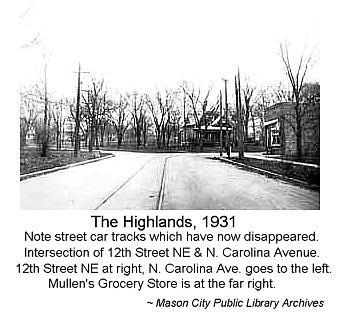
The addition extends north from 12th Street Northeast to 17th Street, west to North Hampshire and east to Kentucky Avenue. It was platted in 1916 by Grand View Development Co., owned by William E. BRICE, FISCHBECK said. A portion of land from just east of Rhode Island Avenue to west of Plymouth Road, commonly associated with the Highlands, was platted in 1904 as Phoebe J. BRENTNER'S Subdivision. Other areas adjacent to the Highlands, extending east to Plymouth Road and west to the Winnebago River, were platted in 1920 as Auditor's Plats. BRICE and his partner, Lewis G. "Lew" ONG, had established a streetcar line in town and Brice extended it into the Highlands, taking it east from the Milwaukee and St. Louis railroad tracks on Fourth Street Northeast, north on North Carolina Avenue, east on 12th Street and north on Rhode Island. He hoped, with the streetcar, to attract housing development in the area, FISCHBECK said. The streetcar made a loop on 15th Place but could also go up to what was then the Legion Golf Course (now Highland Park Golf Course) on 17th Street, residents said. Twelfth Street Northeast in the early days went no farther west than North Carolina. The 12th Street bridge was built in about 1940, Fischbeck said. An iron bridge on 14th Street Northeast crossed the river and came out near DECKERS meatpacking plant. Rhode Island was the only through-street going north in the early years. North Hampshire and North Virginia Avenues ended in a pasture. The area east of Harding Elementary School was wooded. It wasn't until the 1940s that housing development really took off in the Highlands, FISCHBECK said. Mason City attorney/CPA Frank J. ENBUSK formed Associated Builders Co. Inc. to acquire land and build houses in the Highlands, said his former partner, Lyle HILLMER, of Mason City. HILLMER, who came to Mason City in 1946, said by that time the Highlands was pretty much developed. "They'd buy a lot in the morning and sell it in the afternoon," HILLMER said. The houses were Pollman ranch-style houses and one- and-a-half-story homes. By July 1950, the company had built more than Pollman homes, according to Globe Gazette files.
Although today the Highlands is essentially a housing development, several businesses that were focal points of the area have included:
One of the older homes in the North Carolina Avenue area is at 1447 N. Carolina Ave. The two-story house was built in 1895 by Henry and Lydia KUPPINGER. Henry KUPPINGER, a grain miller, built the home across the Winnebago River from the family mill, J. KUPPINGER & Son. Originally located on the west side of North Carolina, the house was moved across the road when the land was quarried, said KUPPINGER'S grandson, Fran MEIER, now deceased, in a 1995 interview. The homestead functioned as a farm on which the KUPPINGERS raised chickens, horses, sheep and pigs. Back then, few houses were located in the area and 14th Street did not exist, MEIER said. Streetlights were not installed on North Carolina beyond 12th Street until after 1967, he said.
Once DECKERS was gone and cement plant emissions were controlled, this area of the city became a popular housing development for more upscale housing, as homeowners sought to take advantage of the natural wooded landscape and view of the Winnebago River. Such housing is being built north of 12th Street Northeast on North Carolina Avenue. New homes are also being built off Plymouth Road - the Mar-Oak Addition and Woodshire Lane - and east on 15th, 15th Place, 16th and 17th streets. Transcription by Sharon R. Becker, May of 2011
|
Return to Cerro Gordo History Index Page Return to Cerro Gordo Home Page