PREFACE.
———
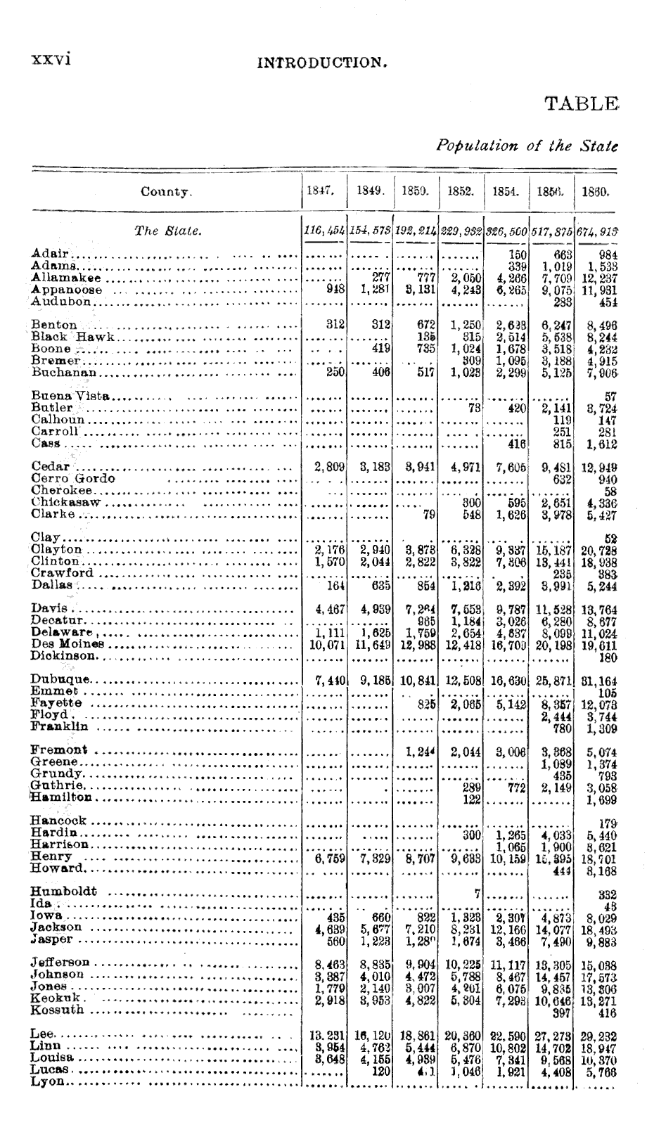
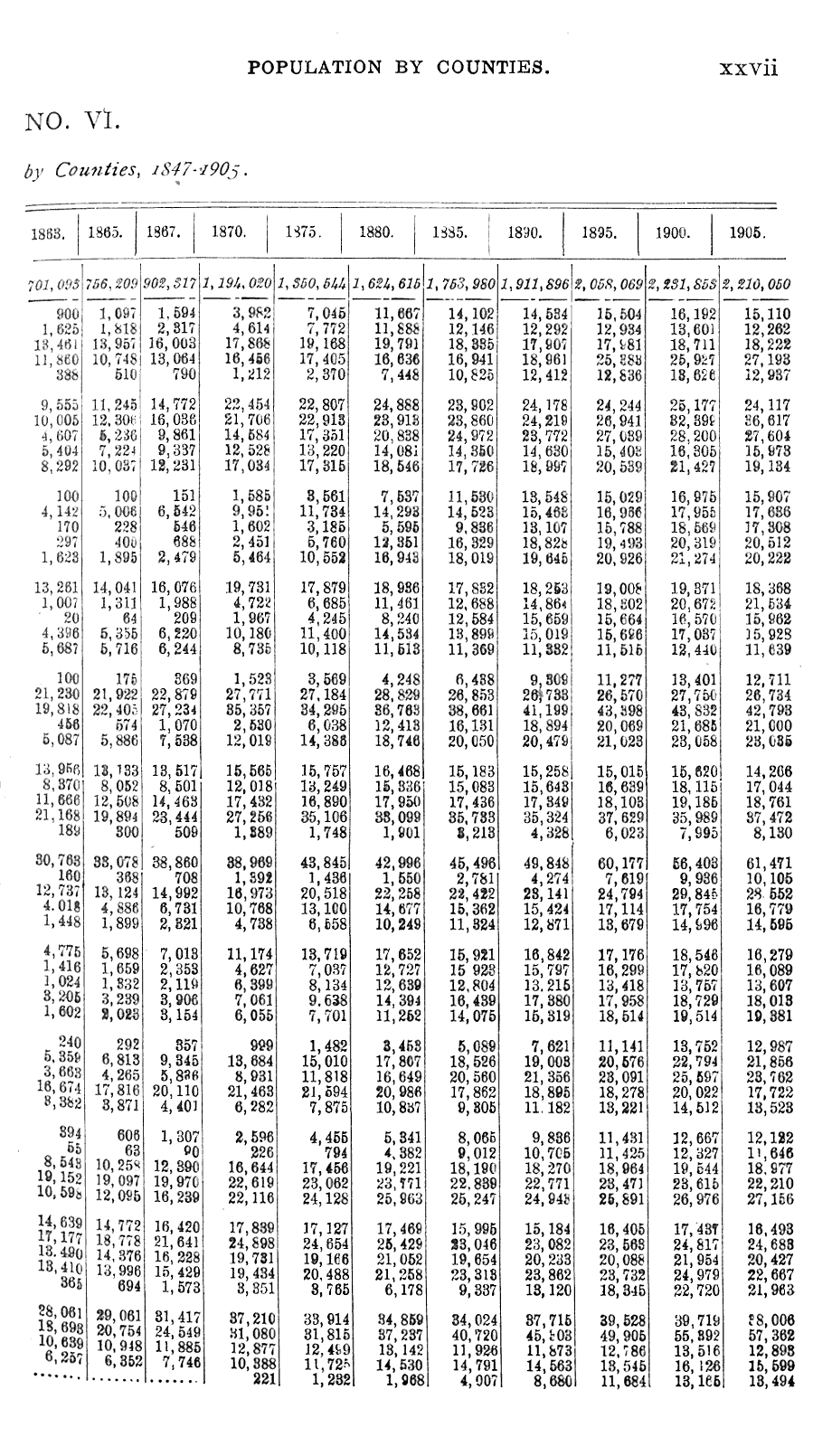
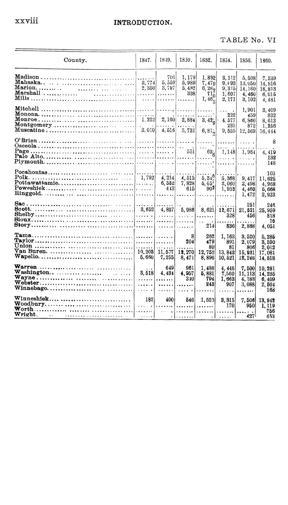
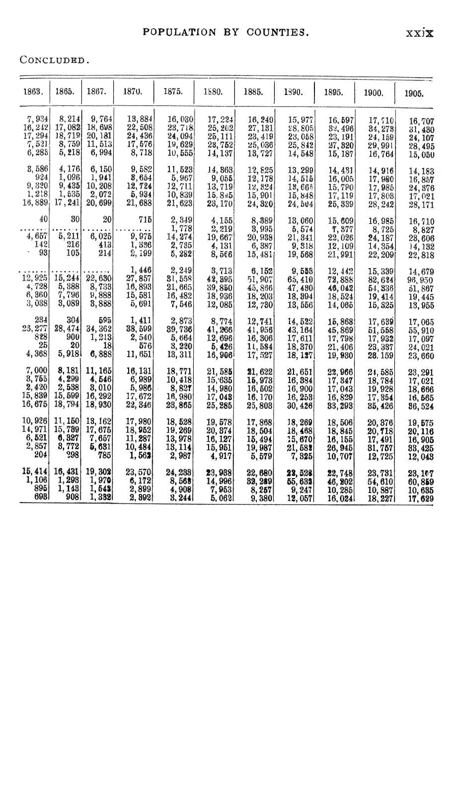
In accordance with the provisions of Chapter 8, Laws of the 30th General Assembly, the Executive Council has prepared the forms suitable for taking a census, and complied the returns made by the county auditors to the Secretary of State. In addition to such compilation, it has added such other statistics relating to matters of public interest as it has been able to procure from the heads of departments and other sources.
The tables which cover the returns as to population and agriculture will be found to embrace many interesting and important facts not hitherto embodied in any state census report. The introduction, which includes the statistics not gathered by the assessor and many comparative tables, is intended not only to show the present condition of the state, but its growth and development. This feature of the present report has never before been attempted in this state, and while it is limited in its scope on account of the appropriation at the disposal of the Council, it is believed that the people will find it very instructive and useful.
The introduction, with its history and comparative tables, was prepared by Prof. W. R. Patterson, who has done his work with signal ability. The returns of the county auditors and their compilation have been under the direction of A. H. Davison, Secretary of the Council. It is due to him to say that his duties have been performed with extraordinary economy and unusual accuracy.
The Council believes it to be its duty to make a statement with respect to the population of the city of Atlantic. The original return made by the assessor showed a population of 5,180. Certain residents of the city brought an action in the District Court of Iowa, for Cass county, against the assessor and members of the Council, alleging that the return was fraudulent in that the assessor had intentionally included many names in the enumeration which out not to have been included. The case was tried and the District Court decided that the assessor had wrongfully enumerated 292 persons, (of these five had not been reckoned in the 5,180,) leaving the population
i
of the city 4,893. The assessor appealed to the Supreme Court, where the suit is now pending. The Council has not appealed and will not appeal; and its members are of the opinion that the publication of the report should not be delayed until the Supreme Court decides the case. Therefore, the population of Atlantic is shown according to the return, as modified by the decree, viz 4,893.
- ALBERT B. CUMMINS,
- W. B. MARTIN,
- B. F. CARROLL,
- G. S. GILBERTSON,
- Executive Council.
Dated at Des Moines, Iowa, this 2d. day of January, 1906.
[balance of page blank]
INTRODUCTION
ACQUISITION OF IOWA LAND FROM THE
INDIANS.
The reverence of the Indian for the "Father of Waters,"and the natural boundary the Mississippi formed, served to check for a considerable period the flood of immigrants that followed the Ohio Valley, or reached the western prairies by way of Pittsburg. As early as 1804 the Sacs and Foxes ceded to the United States their land east of the Mississippi, but it was not until after the defeat of Black Hawk, in 1832, that the most desirable portion of Iowa, "the Beautiful Land," came into possession of the United States. In 1825 Governor Clarke, in council with some three thousand chiefs and warriors at Prairie du Chien, assured them that the "Great Father" wanted "not the smallest piece" of their land; that the only object of their meeting was to bring about peace between the hostile tribes. To this end, it was agreed that the Sioux should remain north and the Sacs and Foxes south of a given line dividing the state from east to west. This line began at the mouth of the upper Iowa river, ascending the river to its left fork which it followed to its source, thence in a direct line to the upper fork of the Des Moines river in Humboldt county, and thence direct to the lower fork of the Calumet river, now known as the Big Sioux, which branch, according to earlier surveys, was north of the Rock river.
This imaginary line, however, failed to restrain the hostile tendency of the warring tribes, and in 1830 several bands of the Sioux ceded a strip of land twenty miles in width from the Mississippi to the Des Moines river situated north and adjoining the line of the treaty of 1825. At the same time the confederated tribes of the Sacs and Foxes made a like cession south of the treaty line, the two acquisitions constituting the so-called "Neutral Strip."
In the same treaty the tribes of the Sacs and Foxes gave the United States that portion of the territory lying west of the watershed dividing the Missouri and Des Moines rivers, east ward to the "Neutral Strip," northward to the present state of Minnesota and westward to the Missouri river, with the exception of a portion of Lyon county which remained in possession of the Sioux.
iii
ivINTRODUCTION.
This vast tract of land was granted with the understanding that it should be used for Indian purposes. The "Neutral Strip" might be hunted upon by either of the tribal parties to the treaty, and the United States was at liberty to settle upon any of the lands, acquired at this date, such other tribes as the President might see fit. In accordance with this agreement, the Winnebagos, after selling their land east of the Mississippi, were settled upon that portion of the "Neutral Strip" to the east of the Cedar river in its course through Butler and Floyd counties, and the Pottawattamies were given 5,000,000 acres in the southwestern part of the present state of Iowa.
The noted warrior, Black Hawk, had vigorously refused to recognize the treaty of 1804 and, although in 1816 he "touched the goose quill," as he expressed it, to the instrument affirming the treaty, his reluctance to give up the land in question led to the conflict of 1832. He was defeated and compelled to sell the land now known as the "Black Hawk Purchase." This gave to the United States a tract about fifty miles in width extending along the Mississippi river from the "Neutral Strip" to the Missouri line, with the exception of the Keokuk Reserve of four hundred square miles along the Iowa river in Louisa county. By this means the eastern portion of the state was secured with the exception of a small tract of land lying between the Des Moines and Mississippi rivers and south of a line drawn west from Ft. Madison, reserved under the treaty made in 1825 for the Half Breeds of the Sacs and Foxes of Missouri, and known as the "Half Breed Tract."
Immigration rapidly spread over the territory thus acquired, and in 1836 the Keokuk Reserve was given over to the United States. A year later, the need of more land being imperative, a tract of 1,250,000 acres lying immediately west of the Black Hawk Purchase was obtained, making what is known as the "Second Purchase."
The treaty of 1830 recognized the claim of the Yankton band of the Sioux to the land ceded at that time, and in 1837 the government purchased their interest, thereby securing undisputed title to the northern portion of the Neutral Strip. At the same time the Missouri Sacs and Foxes, as distinguished from the confederated tribes of Iowa, ceded their interest in the land south of the treaty line of 1825 and between the Mississippi and Missouri rivers. The Iowa bands, who had long been recognized as part owners of the same territory, gave over their interest in
vACQUISITION OF LAND.
1838, but it was not until 1842 that the confederated tribes of the Sacs and Foxes, wavering before the tide of immigration, ceded to the United States all other land east of the Missouri. They agreed to vacate at once that portion of the territory to the east of the line running due north and south from the Painted Rocks on the White Breast fork of the Des Moines river, and within three years from the ratification of the treaty to move west of the Missouri.
The remaining rights of the Indians to the state were procured when the Winnebagos, in 1846, ceded their interest in the Neutral Strip and the Sioux, in 1861, gave title to the northern portion of the present state.
PURCHASE PRICE OF IOWA LANDS.
The exact amount paid the Indians for the lands of Iowa can not be determined. The treaties state the purchase price in terms of money, annuities and merchandise, which latter item it is impossible to fix a value upon at the present time. Another element of uncertainty lies in the overlapping areas of some of the cessions and the extension of several tracts beyond the present confines of the state.
The Neutral Strip and Cession of 1830 was ceded to the United States by certain tribes of the Sioux and the confederated tribes of the Sac and Fox Indians for a sum total of $284,132. The remaining tribes having rights in the territory gave them over in 1837. In the case of the Missouri Sacs and Foxes, however, the cession included not only the above-mentioned tract but all the land between the Mississippi and Missouri rivers, as far north as the treaty line of 1825. The exact extent of the territory claimed by this tribe cannot be determined, but it is probable not over one-fourth of the grant was in the Cession of 1830. The same area was included in the treaty with the lowas in 1838, for which they received practically the same amount of money as the former tribe. Assuming this proportion to be correct, the total cost of the 20,000 square miles of land is $370,007, or about three cents per acre.
The Black Hawk Purchase adjoining the Neutral Strip upon the south, although taken as a result of the Black Hawk War, was made of a strip of land about fifty miles in width, extending along the Mississippi to the southern border of the state and comprising some 7,500 square miles. for this, the government
viINTRODUCTION.
agreed to pay the sum of $665,000, besides giving annually, for thirty years, forty kegs of tobacco and forty pounds of salt.
At the time of making the treaty the tribe was given, for the benefit more particularly of the women who had lost their husbands in the war, a present of thirty-five beef cattle, twelve bushels of salt, thirty barrels of pork, sixty barrels of flour and six thousand bushels of Indian corn. Without estimating the value of these latter products, the cost of the tract to the United States was about fourteen cents per acre.
The Keokuk Reserve was secured for $198,599.87½, giving the United States four hundred square miles of the Iowa Valley at a little less than eight cents per acre. The land immediately west of this tract was more expensive. This purchase included 1,250,000 acres of land, and was secured for $377,000, or a little over thirty cents per acre. Of this sum $200,000 was to be held in trust, the government agreeing to pay at least 5 per cent interest per annum upon the same. The remainder not required for debts or presents was to be expended to procure laborers to help in agricultural pursuits, break up and fence the land still in their possession to the westward, erect two grist mills and purchase a large amount of goods desired by the Indians.
What appears upon the map as the Cession of 1842 was secured by the treaty with the lowas in 1838, and from the Missouri Sacs and Foxes in 1837, under the conditions previously mentioned. The confederated Sacs and Foxes, however, had the greatest interest in this land, and in 1842 sold the same to the United States for $1,058,566.00, which sum, added to the amounts previously mentioned, made the total cost of the tract $1,137,941.00, or ten cents per acre. Of this sum, $878,725 was held in trust by the United States, upon which the usual charge of 5 per cent interest was to be paid.
The remaining strip of land now within the boundaries of the state was along the northern border and legally the property of the Sioux Indians, although at this period they had moved to the northward and occupied what is now southern Minnesota. By 1851 they were convinced of their inability to hold the lands against the advancing whites, and sold what is now a large portion of the state of Minnesota, together with their remaining land in Iowa, for a sum total of $1,390,000. The greater portion of this was to be held in trust under the usual conditions. It appears that about one-tenth of this cession was in the state of Iowa, and therefore the sum of $139,000 may be said to have been paid for this northernmost tract.