IOWA STORIES
Volume 1

By
CLARENCE RAY AURNER

Fourth Edition Printed by the Clio Press Iowa City, Iowa 1920
Copyright 1917 by Clarence Ray Aurner

Transcribed by Sharon Elijah, April 2013


pg 23
OTHER EARLY ROADS pgs 22-33

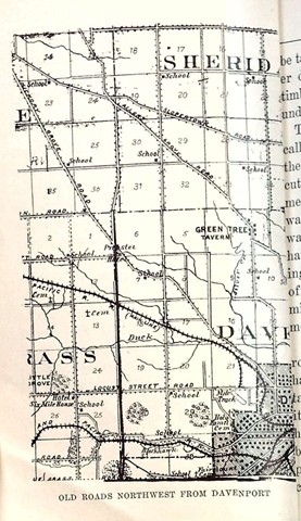
Along the eastern border of the State were the first towns: Dubuque, and Davenport, and Muscatine, and Burlington, and Fort Madison, and Keokuk. By and by others were built inland, among them being Iowa City, which became the capital of the Territory about 1839. Roads to connect these early towns would, of course, be needed as soon as any were located far back from the Mississippi.

In those early days the longest roads were called Territorial roads, because they were laid out across the country to connect these towns in Territorial days. Since there were no railroads then, stage coaches, about which more will be said, ran in all directions over these main routes of travel. Because the capital was at Iowa City many wanted to go in that direction; and one would expect, therefore, to find main roads leading toward that city.

The names of cities like Dubuque and the others just mentioned were applied to these long roads. From Iowa City then there were the Dubuque Road, the Davenport road, the Muscatine road, the Burlington Road, the Prairie du Chien road, the Rochester road, and a good many more.

All of these may have lost now their first names in some parts of the State through which they pass; but such names can be found in any county through which they were laid out, if any one is interested enough to look for them in the books where they are described. Sometimes people have changed the old name, and no one now can tell whether he lives on one of these first roads or on one laid out long afterward.

Not all of these roads needed to be marked with a furrow like the one to Dubuque. Usually they were distinctly laid out by men appointed for that purpose. And since travel increased very rapidly it was not long until such roads were well established. They have been so long used now that one does not stop to think of their beginning.

After these main lines of travel were well known it was not long until people wanted to go across the country in directions between them. For that reason shorter roads had to be laid out to connect the long ones. As these were needed for the settlers who were coming into the State during these early days they were made in directions which men wanted most to go.

When crops had been grown they had to be taken to market or to mill. Now one of the first needs of the new settler was to find a way to get to market or to mill; in fact, roads to such places were necessary at the very beginning of settlement.


pg 26

If farmers wanted a new road, they asked to have it marked out by men named for that purpose. To do this a long chain used in measuring distances, or in laying off land was carried; and a great many stakes had to be taken along to mark off the miles or shorter distances. If the road ran through the timber, axes had to be used to cut away the underbrush.

Those who helped with the chain were called chain carriers; those who drove down the stakes were called “markers”; those who cut away the brush or trees were called axe-men; and the man who had charge of the work was called the surveyor. Beside these there was probably a driver of the wagon which hauled the material used by all of the surveying party. Places on these new roads were often known by the mile stake, as “the nine-mile stake,” or any other mile that might be mentioned to describe a place.

There are a great many of these shorter roads in the earliest counties, and they often have names of men given to them. If a certain man had asked for such a road, or if it ran to his farm, it was probably called by his name. Sometimes the name was given because it ran to a certain place. For example, in one county, at least, there was a road called the “county boundary road”, because it ran to the county line. If a road was called the “Snooks’ Grove Road” or Allen’s Grove Road it must have been named from some person who had given his name to the grove in the beginning.

In northeast Iowa among the hills of Dubuque and the adjoining counties the road had to be made along the valleys. The high bluffs in many places prevented any choice in direction. That part of Iowa is a most delightful place to ride over the country roads. A good many men would be glad to see all that part of northeast Iowa along the Mississippi River kept for a great park. The high bluffs on the river and the beautiful scenery through which the country roads run along the smaller streams are just as interesting as some portions of foreign lands.

There is another kind of scenery in northwest Iowa, where the wide prairies are crossed in straight lines east and west and north and south by roads at each mile.

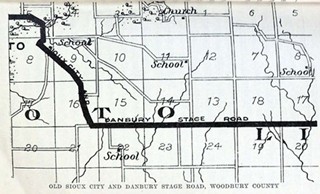
Sometimes there is an exception like the old Sioux City and Danbury stage road crossing Woodbury County diagonally from northwest to southeast. One may imagine a ride on that when the smooth open prairie was all there was to be seen. In very many counties there are few roads which are not rectangular. In Webster County a road runs along the Des Moines River south from Fort Dodge and it probably marks the route of early travel; perhaps it is the very trail over which the first soldiers marched to fight the Sioux and other Indians.


pg 29

Roads leading out from Council Bluffs through the hills and rough lands follow closely along the streams. Indeed they are much like those near the older towns in eastern Iowa. But the early settlement at Council Bluffs would have caused roads to be made in much the same way as they were in other places before the region around was settled or surveyed. In such counties as Osceola or Pocahontas one would search a long time to find a road which did not run like the line dividing the squares on a checker board. In such sections of the State directions are easily kept; and guide boards at the forks in a road would never be found because there would be no forks. Of course, square corners are numerous enough, but those are not so confusing as a dividing place or fork in a main road.

One road which could never have been named in pioneer days is now called in some counties through which it passes the “telegraph road”. Many roads have telephone lines along them, but only one main road across Iowa has a telegraph line along its entire length. Perhaps some who will read this live on the road along which the Transcontinental Telegraph Line is constructed.

It does not seem right to change the old names of the roads or streets to something fanciful, just to suit people who have no interest in preserving the early history. Neither men and women nor boys and girls should wish to destroy that which connects the present with the past of our State. Sometime people may be willing to give attention to these interesting places and will take time to mark them. It is such roads as these Territorial or connection roads that run through farms at an angle, and along which one does not often come to square corners. After the farm houses were built on these, people objected to change, so that now the general direction remains as at the beginning.

The United States Government sometimes wanted a road over which soldiers could travel in the Indian country; or in the new settled parts where there might be danger to white men. Or, perhaps, soldiers were needed to protect the Indian lands before the white men were allowed to come upon them. Very often the white men were driven out by the soldiers from the places they had settled because the land still belonged to the Indians.

The roads built especially for troops to pass over were called military roads. One of these was laid out about 1839 in Iowa, from Dubuque through the counties of Jones, Linn, Johnson, Washington, Henry and Van Buren to the Missouri line. Bridges were built at some places on the road by soldiers and, of course, it became a very important road for all persons. Someone has said that this road formed the main street of Monticello, in Jones County. It crossed the Cedar River at a place called Ivanhoe below Cedar Rapids, and the Iowa River just below Iowa City. Such large streams were crossed at fords or ferries.

Over this route in 1850, the daily stage came from Dubuque. At Monticello there was a station to change horses and drivers; and not far south of that place one might have stopped at the Buckhorn Tavern, which would have been easily known by the deer horns on the archway over the gate. But almost any house on a main traveled road was a tavern to travelers, for no hungry or weary person was turned away, whether or not he had money. On the map of Dubuque County the one road leading from the city directly toward the southwest is called the Dubuque and Cascade military road. This is probably the original route of the United States government road. There were other military roads, but his was the longest one in the Territory of Iowa.

Page created May 6, 2013 by Lynn McCleary

Return to Iowa Stories Volume 1 Contents

Return to Cedar Co. IAGenWeb Home Page