|
Carroll County IAGenWeb |
A Record of Settlement, Organization, Progress and Achievement
VOLUME I ILLUSTRATED
CHICAGO THE S. J. CLARKE PUBLISHING COMPANY 1912
Transcribed and donated by Marilyn Setzler.
CHAPTER III.
|
|
Carroll County IAGenWeb |
Transcribed and donated by Marilyn Setzler.
CHAPTER III.
THE PARTICULAR IN WHICH CARROLL COUNTY EXCELS IS IN THE ABSENCE OF UNARABLE LANDS—TOPOGRAPHY AND NATURAL FEATURES—LOCATION ON MISSISSIPPI-MISSOURI DIVIDE, WHICH TRAVERSES COUNTY—THE VARIOUS ALTITUDES—RIVERS AND STREAMS AND THEIR PECULIARITIES—NATURAL DRAINAGE AND PRESENT RECLAMATION PLANS—SPRING MOUNDS OF THE MIDDLE RACCOON—THEIR GEOLOGICAL SIGNIFICANCE—NATURE OF THE GENERAL SOIL AND ITS GREAT FERTILITY—CARROLL COUNTY DRIFT—POSSIBLE COAL FIELD BUT NO DEVELOPMENT—MANNER IN WHICH LAND TITLES WERE FIRST ACQUIRED—BIG RAILROAD GRANT—PAID FOR WITH CASH OR SOLDIERS' WARRANTS—WHEAT THE IMPORTANT CROP AT FIRST—PRESENT CROPS—FIGURES INDICATING THE PRESENT WEALTH OF THE COUNTY—THE MODIFICATION OF THE CLIMATE.
Of the ninety-nine counties of Iowa, Carroll county is more than typical in its richness in the several attributes which inspired the descriptive mind of Hon. Sidney A. Foster when he first gave utterance to the now well-worn aphorism, "In all that is good, Iowa affords the best." A given area of prime agricultural land in any portion of the state will be found to differ but little from the same amount of land of the same description in any other part of Iowa; there is no profound difference in soil, climate, rainfall or adaptability to cultivable uses. The same crops are grown in all sections practically, and the same labor and intelligence which produces good returns in one locality will, accidental considerations aside, produce as good returns in another or in all. But Carroll county considerably differs from the average Iowa county whose industries are agricultural in the high amount of its arability compared to the whole number of its acres. Its contour is generally that of a rolling prairie. There are no large streams and consequently none of the rough or hilly land which is generally found adjacent to them. Where large streams cut up the country there is waste from the timber tracts abounding and from swamps and the low or broken character of the contiguous territory. These must be subtracted from the total inventory, and what is left after due allowance has been made forms the basis of comparison between the counties, rather than any claimed advantages of soil or climate or other consideration due to natural causes.
Reckoned upon this scale Carroll is equalled [sic] by not more than two or three other counties, for here there may be said to be no waste land at all; meaning, of course, and speaking comparatively, no land that may not year after year be regarded as a potent agricultural asset. The reason for this is that Carroll county lies along the spine of the Mississippi-Missouri divide, so that its lands are among the highest in the state and with as perfect an opportunity for drainage as natural advantages can provide. The summit of this divide is distinctly marked along its entire course through the county, which it enters about the center of Wheatland township and follows a line running through Arcadia and thence southeast to Templeton and beyond. The average altitude of this summit is about 1,425 feet above sea level. The exact elevation of Arcadia is 1,429 feet, of Templeton, 1,452 feet, and it will be noticed that the elevation of the latter is but six feet below that of Spirit Lake (1,458), which is the highest point in Iowa. East of the divide the drainage of the county has its outlet mainly by way of the Middle Coon near Coon Rapids, where the elevation is 1,174 feet, with 278 feet of a fall between the highest point and lowest point of the county, or nearly one-third of the fall in the distance between Templeton and Coon Rapids that these same waters find on their way to Keokuk, where the waters of the Raccoon are poured into the Mississippi through the Des Moines. Here the altitude is 494 feet. Along this ridge or spine is the origin of many small streams running both east and west. So nearly do the heads of these contrary water courses meet that one may stand at the source of one running east and throw a stone into a little channel whose waters have started for the Missouri. The ascent of the decline on the Missouri side is even more marked than it is east of the divide. The natural drainage of Carroll county is, therefore, very exceptional; and as no stream can travel very far from its source and remain in the county there are no large streams and no depredations from water beyond a very small minimum. Neither is there any waste land such as borders large rivers, and which in some counties absorb large areas of their surface. At the same time the county is well watered and is the source of several considerable streams. The headwaters of the Nishnabotna, the principal river in southwestern Iowa, are found in Carroll county, near Manning. The Boyer has its source not far from Arcadia.
The only stream in Carroll county that is sometimes troublesome and destructive is Storm Creek, which has its source in Kniest township, a short distance north of Mt. Carmel, and follows a course slightly east of south to a junction with the Middle Coon, which originates in Carroll county a short distance south of Breda. At various times plans have been discussed to bring Storm Creek under better control. The county authorities have recently shown a marked interest in the project and such steps have been taken by the Board of Supervisors as will within another year or two force Storm Creek to cease its eccentricities and change its nature from a menace to a blessing. It is the largest drainage project ever undertaken by the county and the cost of the improvement will be approximately $215,000: The drainage district comprises 30,000 acres.
Pursuant to a policy inaugurated several years ago the Board of Supervisors has prosecuted the subject of drainage and reclamation with commendable intelligence and industry. With the completion of the Storm creek enterprise at some early day there will remain practically no waste land the redemption of which can be brought about by public agency. While the area to which it applies is nominally 30,000 acres only a very small proportion of it may be properly classed as useless. In the estimates 2,500 acres are given as waste land, (wholly useless at the present time), while in addition only 8,000 acres come under the description of wet land, or land that can be used only a part of the time either on account of its swampy nature or its peculiar liability to overflow. The Storm Creek drainage canal will, it is proposed, carry off the waters of Goose lake and lay bare a tract of two square miles which is now either inundated or covered with a morass which makes it of little value. The rest of the area is distributed into low lands and high lands, which the enterprise will benefit only in degree, and which will contribute to the cost under a graduated scale by which the tax will fall heaviest on the tracts most benefitted and eased as the degree of benefit is removed. This will be the only open ditch in the Carroll county drainage system save one near Coon Rapids, in the building and maintenance of which there is a joint partnership between Carroll and Greene counties. Storm Creek has taken its troublesome qualities from the fact that it threads its way in a most irregular and tortuous channel between low banks through a wide and level bottom, the gradient of the stream at certain intervals being almost imperceptible. The proposed channel will simply straighten the stream, which, relieved of its circuitous detours and thus given a greater fall will discharge itself through this rich and beautiful section without harm. The completion of the Storm Creek system will close the reclamation projects in the county. It is not possible to ascertain the number of acres "brought in" by the various drainage enterprises; but it will be possible to say very shortly that there is in Carroll county no waste land, and that the reclaimed lands are the best that the county affords.
The North Racoon [sic] is the largest river in the county, cutting through Jasper and a corner of Glidden townships, while the next two in importance are the Middle Raccoon and the Bushy [sic corr =Brushy] Fork, which also take their rise in the county on the east slope of the divide and flow nearly parallel from four to six miles apart in a southeasterly direction to their exits in the southeast part of the county. The North Raccoon has cut a deep channel in the drift deposits, and its valley is bordered by steep declivities from seventy to one hundred feet in extent. The Middle Raccoon is bordered on the west by high, bluff-capped slopes and on the east by drift hills which gain the exterior heights by gradual ascents. Bushy [sic corr =Brushy] Fork possesses a beautiful valley, with gentle slopes on either side, which is also the character of the Nishnabotna and Boyer valleys. The upper courses of all these streams are little more than diminutive prairie brooks, running with clear, rapid currents through shallow channels in the black soil. Springs issue along these courses, furnishing them with an abundant supply of pure, limpid water at all seasons of the year. East of the Middle Coon wells are easily obtained, but on the uplands west of that stream wells to furnish a never failing supply must be sunk from 120 to 200 feet. There are many surface wells in this region which supply water abundantly much of the time, but in seasons of extreme drouth [sic] they are not to be depended on. In Greene county, adjoining Carroll on the east, there is a number of flowing wells, but here an artesian water supply has never been known.
In a shallow depression below Carrollton, on the east side of the Middle Raccoon, several interesting spring mounds occur. They have excited attention among geologists, one of whom, Dr. White, describes them as follows: "The plain is thirty or forty feet above the present level of the river, from which it is separated by a well defined drift ridge which, in places, rises into considerable knob-like eminences from one hundred to two hundred and fifty feet above the stream. The plain, however, communicates with the valley both above and below and was probably once the channel of the river. The spring mounds are found along an irregular line more or less in the middle of the depression; they are from four to six feet in height and as many yards in diameter, and are apparently entirely composed of vegetable matter, forming a peaty deposit which is largely mixed with the exuviae of shells and other animal remains. The crests of the mounds are covered with a tall, rank flag or marsh grass, but upon the sides there are usually two well marked bands of short herbage and moss separated by a narrow belt of tall grass. The deposit of the vegetation upon these places is exceedingly interesting, though the mounds themselves, doubtless, owe their origin to the existence of pools of water indicating more or less accurately the course of a former water channel, and which, being fed from higher sources, the tendency is what we observe—the gradual building up of a peaty formation. The surface of the plain beyond the limits of the mounds is perfectly level, and the deposit consists of decayed vegetable matter mixed with sand, forming a sandy muck."
The soil of Carroll county presents two well marked varieties. That on the east of the Middle Raccoon is of the Wisconsin drift formation, and is a gravelly loam. To the west the uplands are deeply enveloped in the bluff deposit found in its purity in the bluffs of the Missouri river. Both soils are deep and rich and will produce a great diversity of crops. Soil analysis gives to Carroll county, beyond the general distinction above mentioned, a singular variety of composition. In fact the county has given its name to a peculiar drift indicating the presence there at one time of a glacial formation the deposit of which is different from the other native drifts, and which is not found elsewhere in western Iowa or in fact in the state. The science of the adaptation of crops to soils is understood by many of the farmers of Carroll county, and the vicinity of the state college at Ames gives them a convenience along the lines of scientific soil study that they are not neglecting.
No beds of coal have yet been discovered in the county though the southern part is on a line with the territory in Greene county in which valuable mines are now in operation. Geologists surmise that this coal measure underlies a portion of the county, but no systematic prospecting has been done and the only specimens yet discovered have been found in digging wells and making other excavations. Some of the specimens thus secured have been analyzed, and while considerable traces of bituminous matter have been found the preponderance of ash and waste is such that they are pronounced no more valuable than bituminous shale, which is of no value at all. However, the time may come when serious efforts will be made to investigate the question of whether coal is or is not to be found in practicable quantities in the fields near Coon Rapids, where the experts declare the surface and other signs point to its presence. This is the only way in which the riddle can be solved. Persons in digging wells have also struck gas as well as coal and this when ignited has burned freely for a time, indicating the presence of natural gas. The informed call this combustible stuff a marsh gas, similar to fire damp, and give its occasional discovery no importance save as it may indicate the vicinity of coal. Peat is also found in several places, but no examination has ever been made of the beds with any practical object in view. Good building stone does not exist in the county, the native sandstone, found at some outcroppings along the Middle Coon, being too friable to serve for building purposes. Brick clay, however, is found in abundance all over the county and local manufacture has been to some extent developed for the making of both brick and drain tile.
The original title to the lands of Carroll county was either acquired through direct purchase from the Iowa Land company, a subsidiary organization of the Cedar Rapids and Missouri River Railroad company (now the Chicago and Northwestern), or patented from the government by means of what were known as soldiers' warrants. On the 15th of May, 1856, congress granted to the state of Iowa certain lands for the purpose of aiding in the construction of railroads from Burlington, on the Mississippi river, to a point on the Missouri river near the mouth of the Platte river; from the city of Davenport, Iowa, by way of Iowa City and Fort Des Moines, to Council Bluffs; from the city of Lyons northwesterly to a point of intersection with the main line of the Iowa Central Air Line railroad near Maquoketa, thence on said line running as near as practicable to the forty-second parallel across the state, and from the city of Dubuque to the Missouri river near Sioux City." The grant comprised the alternate sections designated by odd numbers and lying within six miles from each of the proposed roads. Provision was also made for indemnity for all lands covered by the grant which were already sold or otherwise disposed of.
At this time the Chicago and Northwestern had not yet completed its line to the Mississippi river at Clinton, and the "Iowa Central Air Line Railroad" was a mere figment of the imagination, from which condition it never emerged. The story of the acquirement of the land grant of the "Iowa Air Line" by the Cedar Rapids and Missouri river railroad covers several years both of congress and the legislature, but in 1859 the title was perfected, the first grant having been revoked and a new grant made to the Cedar Rapids and Missouri River company. This company (later the Chicago and Northwestern) thus acquired the land found in alternate sections for six miles on each side of its right of way, and as it was several years before its tracks were completed to the Missouri river, upon its arrival it found some of these lands already sold or otherwise disposed of by the settlement that came in advance of the iron. To compensate the company for this loss congress at a later time extended the limits of the grant to include alternate sections in a territory of twenty miles on each side of the line. Thus a half of the entire area of Carroll county was included in the grant, as the twenty mile limit extended both north and south of the lines of the county, the other half so far as not already occupied of course being open to purchase at the rate of $1.25 per acre outside of the six-mile zone and $2.50 per acre for the lands inside of that limit.� Congress took advantage of the grant to the extent of doubling the price of the reserved lands which it was considered the railroad would benefit and thus in a sense was not a financial loser to this extent in the transaction which alienated so liberal and empire.� The reserved lands were generally disposed of by sale and were paid for in soldiers' warrants, a species of script issued to the soldiers after the Civil war to be received in exchange for land.� Many used their warrants and by this means came into possession of a valuable property, but much of the script was picked up by speculators who bought it at such discounts that the land for which they exchanged it cost them little or nothing.� A few pieces of land on the North Coon river were entered under the homestead laws.� The greater part of the lands of Carroll county were taken at the time they were enacted, however, and the homesteader passed by, moving to regions further west.�
The soil of Carroll county is hospitable to all of the crops which grow out of the ground in the temperate zone, but it is especially adapted to cereal products of all kinds and to grasses, root vegetables and fruits.� Corn and grasses are, however, the crops which stand above and beyond all others, having grown to this commanding position because of the facility with which they are converted into beef and pork and from this form into the coin of the realm.� This has been the result of a development.� The early Carroll county farmers were disposed to diversify their crops if not their methods.� In the early seventies wheat was an important crop, as were also barley and rye.� A considerable quantity of flax was produced at this time.� In the year 1874 413 cars of grain were shipped from Carroll, 278 from Glidden and 210 from Arcadia, making a total of 901 cars, the same towns shipping during the same period 70, 54, and 8 cars respectively of live stock, or a total of 142.� Grain was at this time the preponderant source of wealth to the county, and although the exact proportions can not be ascertained wheat was a more important element in this traffic than corn, if not in bushels or car loads at least in value.� This movement of grain has almost entirely ceased, while the shipping of live stock has multiplied beyond measure.� At so early a period as this satisfactory farm statistics are not available, but in 1885 wheat was still an important crop and 55,454 acres of Carroll county land were devoted to its cultivation, yielding a harvest of 117,254 bushels.� In the year 1909 this acreage of wheat had diminished to 6,253, returning 74,488 bushels.� At the same time the corn area increased from 92,000 acres to 103,000 acres, a large part of the wheat and other grain lands having been converted into pasture to accommodate an increase of nearly a hundred per cent (25,900 against 47,590) in cattle, a large increase in hogs, milk cows, poultry and poultry and dairy products—all the result of an evolution along the lines of least resistance; or, in other words, the concentration of production to the forms commensurate with the largest and most satisfactory returns both to the soil and the pocket.� To what extent habit may have followed in the course of the natural tendency is another question.� The grain crops of the past year, limited as has been their acreage, have been a source of surprise to many who have taken it for granted that the elements which are necessary for small grains, and especially for wheat, were exhausted from the soil by the efforts of the pioneer farmers to grow bread instead of beef.
However, the policy which has been followed has witnessed the increase in farm lands in price from $25 to $40 per acre to the stage where $100 land is a rare bargain for that which is poorest in quality, least improved or most remote from trading points, while far the larger part of the farms offered for sale command prices ranging from $150 to $200 per acre. The farms have grown in size since 1885, when the average was 141 acres. In 1909 the average farm consisted of 171 acres, and this with a loss of rural population of 225 in addition to a further loss in proportion to the growth of the towns. Carroll county is not alone in this loss of population, which is a state wide condition; in fact the loss here is not so great by considerable as that found in adjoining counties; but the increase of holdings and the decrease of population do not stand for a situation wholly desirable. The advance of land would seem to call for more diversified and more intensive methods of farming, demanding an increase of labor and therefore of hands to perform the labor. Rents have not increased in keeping with the advance of land, the prevailing price at this time being from four to five dollars an acre or a crop rent of three-fifths and two-fifths. These matters are stated as rather curious facts of the present time and are passed on to the future for such explanation as it may resolve upon.
The national census of 1910 is still in course of preparation and information from that source is not to be obtained at this time. However, a very close and intelligent compilation was made of the farm statistics of the county from the returns of the assessors of 1909. There were under cultivation in that year 323,482 acres, divided among 1,892 occupants—not distinguished in the return as between owners and tenants—who farmed an average of 171 acres. Of this acreage 102,201 acres were planted to corn and produced a yield of 3,696,820 bushels. Eden township had the largest corn fields, consisting of 8,167 acres and a production of 300,773 bushels, an average of thirty-eight bushels per acre. Glidden followed with nearly as large an acreage but a smaller average yield. Wheatland, with a much smaller acreage, produced an average of forty-one bushels to the acre.
There were 6,253 acres of spring wheat, producing 11.9 bushels per acre or a total of 74,488 bushels. There were seeded to barley, 7,208 acres, with an average yield of 14.7 bushels. To hay raising were devoted 39,729 acres, with a general yield of one and one-half tons per acre. In this crop Union township stood at first place, with an acreage of 22,753, making an average of two tons. The number of acres planted to potatoes was 21,245, and the yield, 228,266, an average of 107 bushels.
During the year Carroll county laid 194,982 rods of drain tiling, Richland township leading with 44,534 rods, followed closely by Glidden, Jasper, Pleasant Valley, Union and Grant. Practically no tiling was done in the west side of the county.
A count of the domestic animals gives the following result: Horses, 13,531; mules, 425; hogs, 70,108; cattle, 47,590. Of cattle sold for slaughter there were 7,404 head. The above figure includes 11,585 milk cows which produced 544,566 pounds of butter, 363,565 of which was sold for profit. Roselle was the banner butter township, with 910 cows, from which were sold 22,189 pounds of butter. In dairy importance Pleasant Valley ranked second and Glidden last, with 482 cows and 12,153 pounds of butter for market.
In this census 284,919 chickens were counted, of which 80,470 went to market and the remainder furnished to the world 721,000 dozens of eggs. Sheridan township takes first place in egg production, with 72,650 dozen, followed by Warren and Wheatland, with 63,000 dozen each.
A considerable change has taken place in the climate of Carroll county since its early settlement, when storms of so severe a character as to be traditional were occasional incidents of both the summer and winter seasons. The pioneers relate accounts of snows so deep that a sleigh could be driven on its frozen surface above the tops of the stakes of the stake and rider fences, with 30 to 40 degrees of cold over long periods of the winter. In these old times violent storms were frequent during the summer, and one or two destructive tornadoes were among the expected annual visitors. One of the first records made by the Iowa so-called cyclone was found in the destruction of the town of Camanche, north of Clinton, on the Mississippi river, in the year 1860. This storm was so notable in character and disastrous in results that an attempt was made to follow it back to its origin, and its traces were found as far west as Calhoun county, where the search was abandoned. A report of the incident says that the course of the tornado in Calhoun county shows that it invaded that section from the southwest and that it must have "originated in Carroll county or the Missouri bottoms across the divide." In the '70s storms of this character, though of course not so severe, were not infrequent. For the past twenty years, however, they have been little known, and while the summers have been free from any alarming disturbances of this kind, the winters also have moderated distinctly both in snowfall and in point of temperature. Indeed, as the face of the prairie has gradually grown from a naked plain to a surface of farms upon each of which groves have been grown and buildings erected to interrupt the free play of the elements, the excesses of the climate have been brought under control, and the seasons come and go without exciting more apprehension than is found in the tolerable certainty that December and January will bring a moderate amount of inclemency, and that in August a term may be expected for which no word is found in the new version to furnish a suitable description.
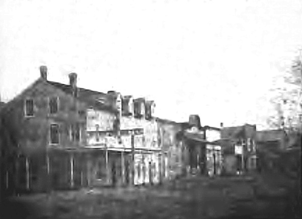
Main St., Carroll, looking North, 1878
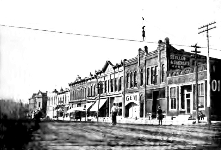
Main Street